Chunping Qiu
CEIDM: A Controlled Entity and Interaction Diffusion Model for Enhanced Text-to-Image Generation
Aug 25, 2025Abstract:In Text-to-Image (T2I) generation, the complexity of entities and their intricate interactions pose a significant challenge for T2I method based on diffusion model: how to effectively control entity and their interactions to produce high-quality images. To address this, we propose CEIDM, a image generation method based on diffusion model with dual controls for entity and interaction. First, we propose an entity interactive relationships mining approach based on Large Language Models (LLMs), extracting reasonable and rich implicit interactive relationships through chain of thought to guide diffusion models to generate high-quality images that are closer to realistic logic and have more reasonable interactive relationships. Furthermore, We propose an interactive action clustering and offset method to cluster and offset the interactive action features contained in each text prompts. By constructing global and local bidirectional offsets, we enhance semantic understanding and detail supplementation of original actions, making the model's understanding of the concept of interactive "actions" more accurate and generating images with more accurate interactive actions. Finally, we design an entity control network which generates masks with entity semantic guidance, then leveraging multi-scale convolutional network to enhance entity feature and dynamic network to fuse feature. It effectively controls entities and significantly improves image quality. Experiments show that the proposed CEIDM method is better than the most representative existing methods in both entity control and their interaction control.
Dynamic Embedding of Hierarchical Visual Features for Efficient Vision-Language Fine-Tuning
Aug 25, 2025Abstract:Large Vision-Language Models (LVLMs) commonly follow a paradigm that projects visual features and then concatenates them with text tokens to form a unified sequence input for Large Language Models (LLMs). However, this paradigm leads to a significant increase in the length of the input sequence, resulting in substantial computational overhead. Existing methods attempt to fuse visual information into the intermediate layers of LLMs, which alleviate the sequence length issue but often neglect the hierarchical semantic representations within the model and the fine-grained visual information available in the shallower visual encoding layers. To address this limitation, we propose DEHVF, an efficient vision-language fine-tuning method based on dynamic embedding and fusion of hierarchical visual features. Its core lies in leveraging the inherent hierarchical representation characteristics of visual encoders and language models. Through a lightweight hierarchical visual fuser, it dynamically selects and fuses hierarchical features corresponding to semantic granularity based on the internal representations of each layer in LLMs. The fused layer-related visual features are then projected and aligned before being directly embedded into the Feed-Forward Network (FFN) of the corresponding layer in LLMs. This approach not only avoids sequence expansion but also dynamically fuses multi-layer visual information. By fine-tuning only a small number of parameters, DEHVF achieves precise alignment and complementarity of cross-modal information at the same semantic granularity. We conducted experiments across various VL benchmarks, including visual question answering on ScienceQA and image captioning on COCO Captions. The results demonstrate that DEHVF achieves higher accuracy than existing parameter-efficient fine-tuning (PEFT) baselines while maintaining efficient training and inference.
Separation and Collaboration: Two-Level Routing Grouped Mixture-of-Experts for Multi-Domain Continual Learning
Aug 11, 2025Abstract:Multi-Domain Continual Learning (MDCL) acquires knowledge from sequential tasks with shifting class sets and distribution. Despite the Parameter-Efficient Fine-Tuning (PEFT) methods can adapt for this dual heterogeneity, they still suffer from catastrophic forgetting and forward forgetting. To address these challenges, we propose a Two-Level Routing Grouped Mixture-of-Experts (TRGE) method. Firstly, TRGE dynamically expands the pre-trained CLIP model, assigning specific expert group for each task to mitigate catastrophic forgetting. With the number of experts continually grows in this process, TRGE maintains the static experts count within the group and introduces the intra-group router to alleviate routing overfitting caused by the increasing routing complexity. Meanwhile, we design an inter-group routing policy based on task identifiers and task prototype distance, which dynamically selects relevant expert groups and combines their outputs to enhance inter-task collaboration. Secondly, to get the correct task identifiers, we leverage Multimodal Large Language Models (MLLMs) which own powerful multimodal comprehension capabilities to generate semantic task descriptions and recognize the correct task identifier. Finally, to mitigate forward forgetting, we dynamically fuse outputs for unseen samples from the frozen CLIP model and TRGE adapter based on training progress, leveraging both pre-trained and learned knowledge. Through extensive experiments across various settings, our method outperforms other advanced methods with fewer trainable parameters.
D3HRL: A Distributed Hierarchical Reinforcement Learning Approach Based on Causal Discovery and Spurious Correlation Detection
May 04, 2025


Abstract:Current Hierarchical Reinforcement Learning (HRL) algorithms excel in long-horizon sequential decision-making tasks but still face two challenges: delay effects and spurious correlations. To address them, we propose a causal HRL approach called D3HRL. First, D3HRL models delayed effects as causal relationships across different time spans and employs distributed causal discovery to learn these relationships. Second, it employs conditional independence testing to eliminate spurious correlations. Finally, D3HRL constructs and trains hierarchical policies based on the identified true causal relationships. These three steps are iteratively executed, gradually exploring the complete causal chain of the task. Experiments conducted in 2D-MineCraft and MiniGrid show that D3HRL demonstrates superior sensitivity to delay effects and accurately identifies causal relationships, leading to reliable decision-making in complex environments.
Pairwise Similarity Regularization for Semi-supervised Graph Medical Image Segmentation
Mar 17, 2025


Abstract:With fully leveraging the value of unlabeled data, semi-supervised medical image segmentation algorithms significantly reduces the limitation of limited labeled data, achieving a significant improvement in accuracy. However, the distributional shift between labeled and unlabeled data weakens the utilization of information from the labeled data. To alleviate the problem, we propose a graph network feature alignment method based on pairwise similarity regularization (PaSR) for semi-supervised medical image segmentation. PaSR aligns the graph structure of images in different domains by maintaining consistency in the pairwise structural similarity of feature graphs between the target domain and the source domain, reducing distribution shift issues in medical images. Meanwhile, further improving the accuracy of pseudo-labels in the teacher network by aligning graph clustering information to enhance the semi-supervised efficiency of the model. The experimental part was verified on three medical image segmentation benchmark datasets, with results showing improvements over advanced methods in various metrics. On the ACDC dataset, it achieved an average improvement of more than 10.66%.
MVP: Meta Visual Prompt Tuning for Few-Shot Remote Sensing Image Scene Classification
Sep 17, 2023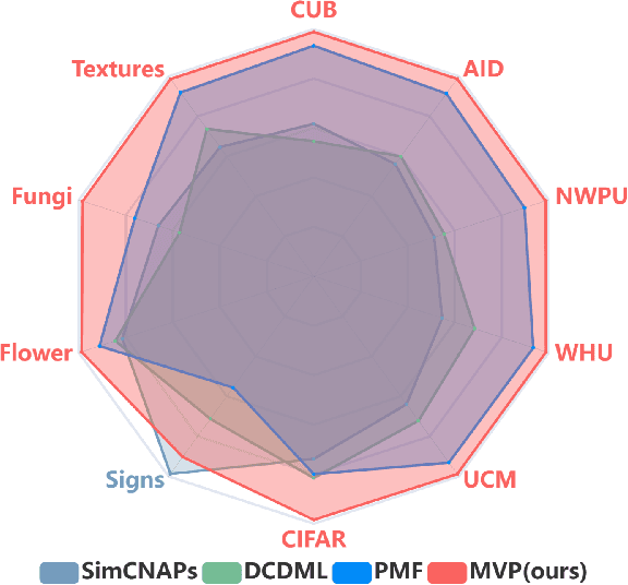
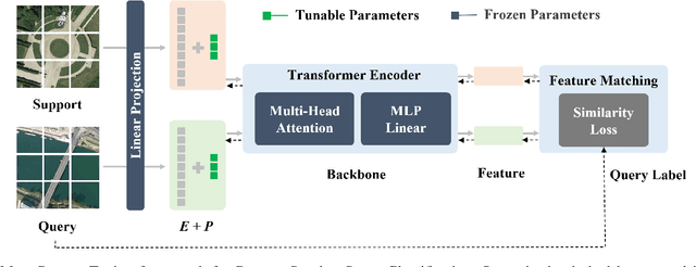
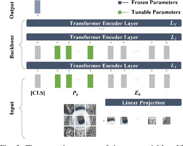
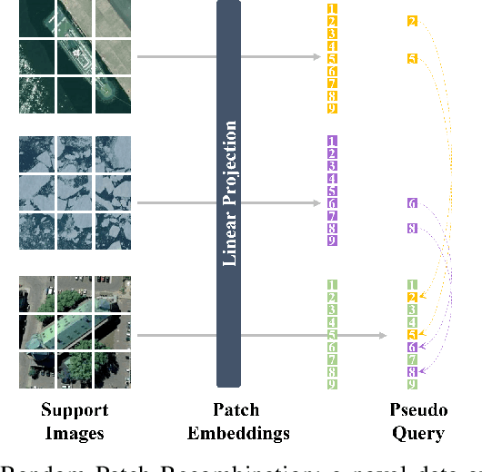
Abstract:Vision Transformer (ViT) models have recently emerged as powerful and versatile models for various visual tasks. Recently, a work called PMF has achieved promising results in few-shot image classification by utilizing pre-trained vision transformer models. However, PMF employs full fine-tuning for learning the downstream tasks, leading to significant overfitting and storage issues, especially in the remote sensing domain. In order to tackle these issues, we turn to the recently proposed parameter-efficient tuning methods, such as VPT, which updates only the newly added prompt parameters while keeping the pre-trained backbone frozen. Inspired by VPT, we propose the Meta Visual Prompt Tuning (MVP) method. Specifically, we integrate the VPT method into the meta-learning framework and tailor it to the remote sensing domain, resulting in an efficient framework for Few-Shot Remote Sensing Scene Classification (FS-RSSC). Furthermore, we introduce a novel data augmentation strategy based on patch embedding recombination to enhance the representation and diversity of scenes for classification purposes. Experiment results on the FS-RSSC benchmark demonstrate the superior performance of the proposed MVP over existing methods in various settings, such as various-way-various-shot, various-way-one-shot, and cross-domain adaptation.
Sea Ice Extraction via Remote Sensed Imagery: Algorithms, Datasets, Applications and Challenges
Jun 01, 2023Abstract:The deep learning, which is a dominating technique in artificial intelligence, has completely changed the image understanding over the past decade. As a consequence, the sea ice extraction (SIE) problem has reached a new era. We present a comprehensive review of four important aspects of SIE, including algorithms, datasets, applications, and the future trends. Our review focuses on researches published from 2016 to the present, with a specific focus on deep learning-based approaches in the last five years. We divided all relegated algorithms into 3 categories, including classical image segmentation approach, machine learning-based approach and deep learning-based methods. We reviewed the accessible ice datasets including SAR-based datasets, the optical-based datasets and others. The applications are presented in 4 aspects including climate research, navigation, geographic information systems (GIS) production and others. It also provides insightful observations and inspiring future research directions.
Multi-task Learning for Human Settlement Extent Regression and Local Climate Zone Classification
Nov 23, 2020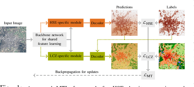
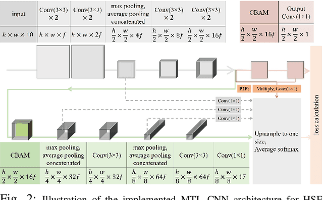


Abstract:Human Settlement Extent (HSE) and Local Climate Zone (LCZ) maps are both essential sources, e.g., for sustainable urban development and Urban Heat Island (UHI) studies. Remote sensing (RS)- and deep learning (DL)-based classification approaches play a significant role by providing the potential for global mapping. However, most of the efforts only focus on one of the two schemes, usually on a specific scale. This leads to unnecessary redundancies, since the learned features could be leveraged for both of these related tasks. In this letter, the concept of multi-task learning (MTL) is introduced to HSE regression and LCZ classification for the first time. We propose a MTL framework and develop an end-to-end Convolutional Neural Network (CNN), which consists of a backbone network for shared feature learning, attention modules for task-specific feature learning, and a weighting strategy for balancing the two tasks. We additionally propose to exploit HSE predictions as a prior for LCZ classification to enhance the accuracy. The MTL approach was extensively tested with Sentinel-2 data of 13 cities across the world. The results demonstrate that the framework is able to provide a competitive solution for both tasks.
Multi-level Feature Fusion-based CNN for Local Climate Zone Classification from Sentinel-2 Images: Benchmark Results on the So2Sat LCZ42 Dataset
May 16, 2020


Abstract:As a unique classification scheme for urban forms and functions, the local climate zone (LCZ) system provides essential general information for any studies related to urban environments, especially on a large scale. Remote sensing data-based classification approaches are the key to large-scale mapping and monitoring of LCZs. The potential of deep learning-based approaches is not yet fully explored, even though advanced convolutional neural networks (CNNs) continue to push the frontiers for various computer vision tasks. One reason is that published studies are based on different datasets, usually at a regional scale, which makes it impossible to fairly and consistently compare the potential of different CNNs for real-world scenarios. This study is based on the big So2Sat LCZ42 benchmark dataset dedicated to LCZ classification. Using this dataset, we studied a range of CNNs of varying sizes. In addition, we proposed a CNN to classify LCZs from Sentinel-2 images, Sen2LCZ-Net. Using this base network, we propose fusing multi-level features using the extended Sen2LCZ-Net-MF. With this proposed simple network architecture and the highly competitive benchmark dataset, we obtain results that are better than those obtained by the state-of-the-art CNNs, while requiring less computation with fewer layers and parameters. Large-scale LCZ classification examples of completely unseen areas are presented, demonstrating the potential of our proposed Sen2LCZ-Net-MF as well as the So2Sat LCZ42 dataset. We also intensively investigated the influence of network depth and width and the effectiveness of the design choices made for Sen2LCZ-Net-MF. Our work will provide important baselines for future CNN-based algorithm developments for both LCZ classification and other urban land cover land use classification.
So2Sat LCZ42: A Benchmark Dataset for Global Local Climate Zones Classification
Dec 19, 2019


Abstract:Access to labeled reference data is one of the grand challenges in supervised machine learning endeavors. This is especially true for an automated analysis of remote sensing images on a global scale, which enables us to address global challenges such as urbanization and climate change using state-of-the-art machine learning techniques. To meet these pressing needs, especially in urban research, we provide open access to a valuable benchmark dataset named "So2Sat LCZ42," which consists of local climate zone (LCZ) labels of about half a million Sentinel-1 and Sentinel-2 image patches in 42 urban agglomerations (plus 10 additional smaller areas) across the globe. This dataset was labeled by 15 domain experts following a carefully designed labeling work flow and evaluation process over a period of six months. As rarely done in other labeled remote sensing dataset, we conducted rigorous quality assessment by domain experts. The dataset achieved an overall confidence of 85%. We believe this LCZ dataset is a first step towards an unbiased globallydistributed dataset for urban growth monitoring using machine learning methods, because LCZ provide a rather objective measure other than many other semantic land use and land cover classifications. It provides measures of the morphology, compactness, and height of urban areas, which are less dependent on human and culture. This dataset can be accessed from http://doi.org/10.14459/2018mp1483140.
 Add to Chrome
 Add to Firefox
 Add to Edge