Lloyd H. Hughes
Multi-task Learning for Human Settlement Extent Regression and Local Climate Zone Classification
Nov 23, 2020


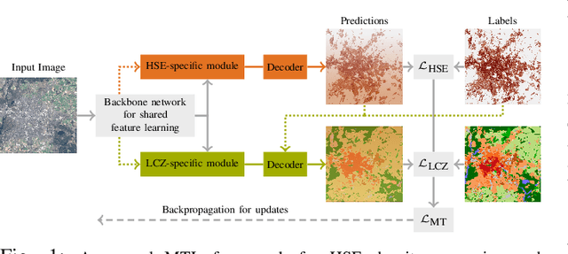
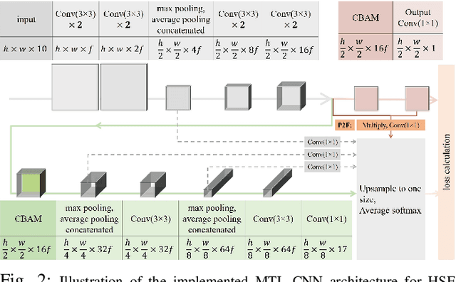
Abstract:Human Settlement Extent (HSE) and Local Climate Zone (LCZ) maps are both essential sources, e.g., for sustainable urban development and Urban Heat Island (UHI) studies. Remote sensing (RS)- and deep learning (DL)-based classification approaches play a significant role by providing the potential for global mapping. However, most of the efforts only focus on one of the two schemes, usually on a specific scale. This leads to unnecessary redundancies, since the learned features could be leveraged for both of these related tasks. In this letter, the concept of multi-task learning (MTL) is introduced to HSE regression and LCZ classification for the first time. We propose a MTL framework and develop an end-to-end Convolutional Neural Network (CNN), which consists of a backbone network for shared feature learning, attention modules for task-specific feature learning, and a weighting strategy for balancing the two tasks. We additionally propose to exploit HSE predictions as a prior for LCZ classification to enhance the accuracy. The MTL approach was extensively tested with Sentinel-2 data of 13 cities across the world. The results demonstrate that the framework is able to provide a competitive solution for both tasks.
Identifying Corresponding Patches in SAR and Optical Images with a Pseudo-Siamese CNN
Jan 25, 2018


Abstract:In this letter, we propose a pseudo-siamese convolutional neural network (CNN) architecture that enables to solve the task of identifying corresponding patches in very-high-resolution (VHR) optical and synthetic aperture radar (SAR) remote sensing imagery. Using eight convolutional layers each in two parallel network streams, a fully connected layer for the fusion of the features learned in each stream, and a loss function based on binary cross-entropy, we achieve a one-hot indication if two patches correspond or not. The network is trained and tested on an automatically generated dataset that is based on a deterministic alignment of SAR and optical imagery via previously reconstructed and subsequently co-registered 3D point clouds. The satellite images, from which the patches comprising our dataset are extracted, show a complex urban scene containing many elevated objects (i.e. buildings), thus providing one of the most difficult experimental environments. The achieved results show that the network is able to predict corresponding patches with high accuracy, thus indicating great potential for further development towards a generalized multi-sensor key-point matching procedure. Index Terms-synthetic aperture radar (SAR), optical imagery, data fusion, deep learning, convolutional neural networks (CNN), image matching, deep matching
 Add to Chrome
 Add to Firefox
 Add to Edge