Stefan Hinz
Novel View Synthesis with Neural Radiance Fields for Industrial Robot Applications
May 07, 2024Abstract:Neural Radiance Fields (NeRFs) have become a rapidly growing research field with the potential to revolutionize typical photogrammetric workflows, such as those used for 3D scene reconstruction. As input, NeRFs require multi-view images with corresponding camera poses as well as the interior orientation. In the typical NeRF workflow, the camera poses and the interior orientation are estimated in advance with Structure from Motion (SfM). But the quality of the resulting novel views, which depends on different parameters such as the number and distribution of available images, as well as the accuracy of the related camera poses and interior orientation, is difficult to predict. In addition, SfM is a time-consuming pre-processing step, and its quality strongly depends on the image content. Furthermore, the undefined scaling factor of SfM hinders subsequent steps in which metric information is required. In this paper, we evaluate the potential of NeRFs for industrial robot applications. We propose an alternative to SfM pre-processing: we capture the input images with a calibrated camera that is attached to the end effector of an industrial robot and determine accurate camera poses with metric scale based on the robot kinematics. We then investigate the quality of the novel views by comparing them to ground truth, and by computing an internal quality measure based on ensemble methods. For evaluation purposes, we acquire multiple datasets that pose challenges for reconstruction typical of industrial applications, like reflective objects, poor texture, and fine structures. We show that the robot-based pose determination reaches similar accuracy as SfM in non-demanding cases, while having clear advantages in more challenging scenarios. Finally, we present first results of applying the ensemble method to estimate the quality of the synthetic novel view in the absence of a ground truth.
FaSS-MVS -- Fast Multi-View Stereo with Surface-Aware Semi-Global Matching from UAV-borne Monocular Imagery
Dec 01, 2021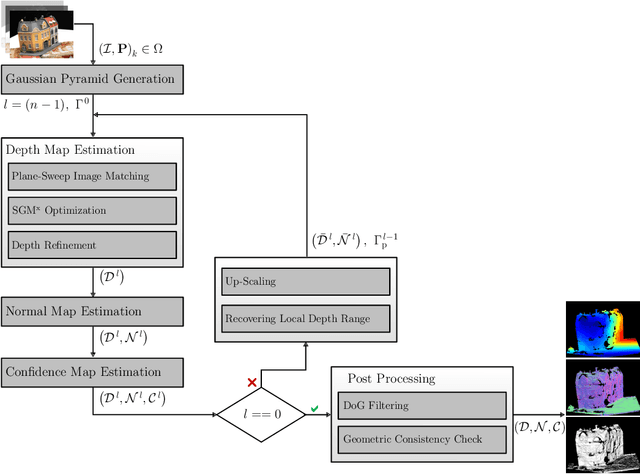


Abstract:With FaSS-MVS, we present an approach for fast multi-view stereo with surface-aware Semi-Global Matching that allows for rapid depth and normal map estimation from monocular aerial video data captured by UAVs. The data estimated by FaSS-MVS, in turn, facilitates online 3D mapping, meaning that a 3D map of the scene is immediately and incrementally generated while the image data is acquired or being received. FaSS-MVS is comprised of a hierarchical processing scheme in which depth and normal data, as well as corresponding confidence scores, are estimated in a coarse-to-fine manner, allowing to efficiently process large scene depths which are inherent to oblique imagery captured by low-flying UAVs. The actual depth estimation employs a plane-sweep algorithm for dense multi-image matching to produce depth hypotheses from which the actual depth map is extracted by means of a surface-aware semi-global optimization, reducing the fronto-parallel bias of SGM. Given the estimated depth map, the pixel-wise surface normal information is then computed by reprojecting the depth map into a point cloud and calculating the normal vectors within a confined local neighborhood. In a thorough quantitative and ablative study we show that the accuracies of the 3D information calculated by FaSS-MVS is close to that of state-of-the-art approaches for offline multi-view stereo, with the error not even being one magnitude higher than that of COLMAP. At the same time, however, the average run-time of FaSS-MVS to estimate a single depth and normal map is less than 14 % of that of COLMAP, allowing to perform an online and incremental processing of Full-HD imagery at 1-2 Hz.
Pose Normalization of Indoor Mapping Datasets Partially Compliant to the Manhattan World Assumption
Jul 16, 2021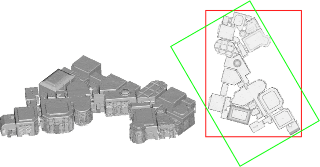
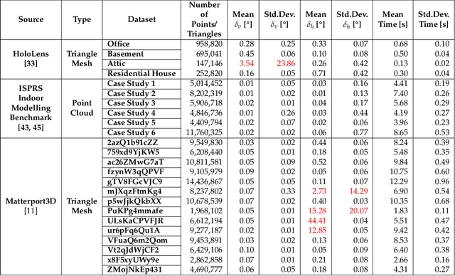
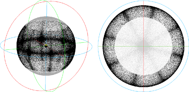
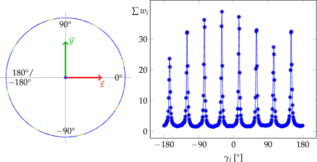
Abstract:In this paper, we present a novel pose normalization method for indoor mapping point clouds and triangle meshes that is robust against large fractions of the indoor mapping geometries deviating from an ideal Manhattan World structure. In the case of building structures that contain multiple Manhattan World systems, the dominant Manhattan World structure supported by the largest fraction of geometries is determined and used for alignment. In a first step, a vertical alignment orienting a chosen axis to be orthogonal to horizontal floor and ceiling surfaces is conducted. Subsequently, a rotation around the resulting vertical axis is determined that aligns the dataset horizontally with the coordinate axes. The proposed method is evaluated quantitatively against several publicly available indoor mapping datasets. Our implementation of the proposed procedure along with code for reproducing the evaluation will be made available to the public upon acceptance for publication.
ReS2tAC -- UAV-Borne Real-Time SGM Stereo Optimized for Embedded ARM and CUDA Devices
Jun 15, 2021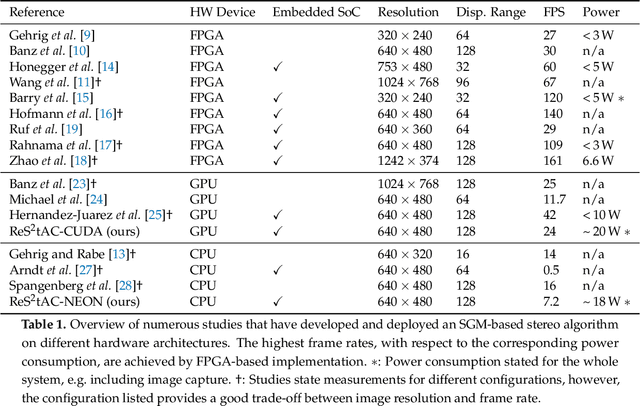


Abstract:With the emergence of low-cost robotic systems, such as unmanned aerial vehicle, the importance of embedded high-performance image processing has increased. For a long time, FPGAs were the only processing hardware that were capable of high-performance computing, while at the same time preserving a low power consumption, essential for embedded systems. However, the recently increasing availability of embedded GPU-based systems, such as the NVIDIA Jetson series, comprised of an ARM CPU and a NVIDIA Tegra GPU, allows for massively parallel embedded computing on graphics hardware. With this in mind, we propose an approach for real-time embedded stereo processing on ARM and CUDA-enabled devices, which is based on the popular and widely used Semi-Global Matching algorithm. In this, we propose an optimization of the algorithm for embedded CUDA GPUs, by using massively parallel computing, as well as using the NEON intrinsics to optimize the algorithm for vectorized SIMD processing on embedded ARM CPUs. We have evaluated our approach with different configurations on two public stereo benchmark datasets to demonstrate that they can reach an error rate as low as 3.3%. Furthermore, our experiments show that the fastest configuration of our approach reaches up to 46 FPS on VGA image resolution. Finally, in a use-case specific qualitative evaluation, we have evaluated the power consumption of our approach and deployed it on the DJI Manifold 2-G attached to a DJI Matrix 210v2 RTK unmanned aerial vehicle (UAV), demonstrating its suitability for real-time stereo processing onboard a UAV.
FAIR1M: A Benchmark Dataset for Fine-grained Object Recognition in High-Resolution Remote Sensing Imagery
Mar 24, 2021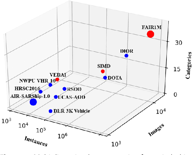
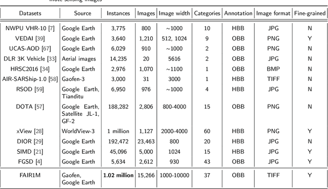
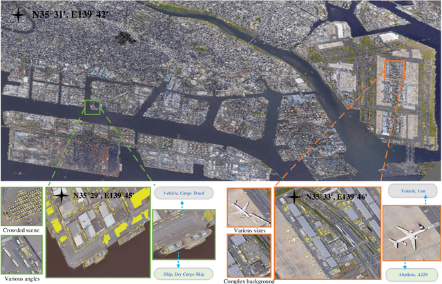
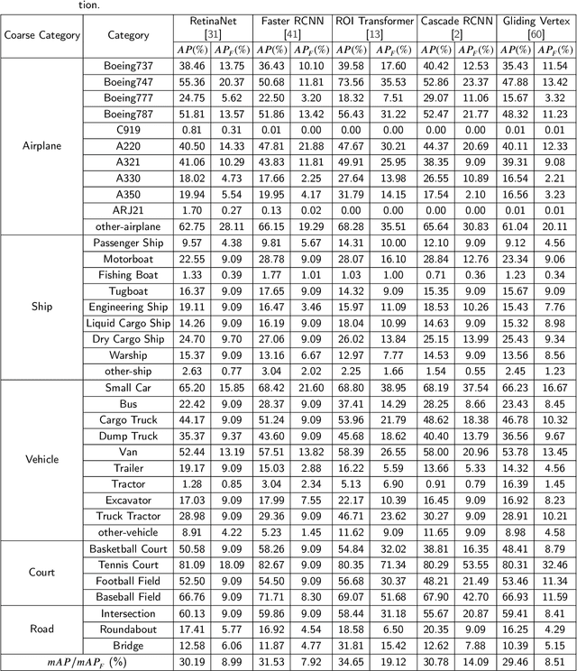
Abstract:With the rapid development of deep learning, many deep learning-based approaches have made great achievements in object detection task. It is generally known that deep learning is a data-driven method. Data directly impact the performance of object detectors to some extent. Although existing datasets have included common objects in remote sensing images, they still have some limitations in terms of scale, categories, and images. Therefore, there is a strong requirement for establishing a large-scale benchmark on object detection in high-resolution remote sensing images. In this paper, we propose a novel benchmark dataset with more than 1 million instances and more than 15,000 images for Fine-grAined object recognItion in high-Resolution remote sensing imagery which is named as FAIR1M. All objects in the FAIR1M dataset are annotated with respect to 5 categories and 37 sub-categories by oriented bounding boxes. Compared with existing detection datasets dedicated to object detection, the FAIR1M dataset has 4 particular characteristics: (1) it is much larger than other existing object detection datasets both in terms of the quantity of instances and the quantity of images, (2) it provides more rich fine-grained category information for objects in remote sensing images, (3) it contains geographic information such as latitude, longitude and resolution, (4) it provides better image quality owing to a careful data cleaning procedure. To establish a baseline for fine-grained object recognition, we propose a novel evaluation method and benchmark fine-grained object detection tasks and a visual classification task using several State-Of-The-Art (SOTA) deep learning-based models on our FAIR1M dataset. Experimental results strongly indicate that the FAIR1M dataset is closer to practical application and it is considerably more challenging than existing datasets.
Self-Supervised Learning for Monocular Depth Estimation from Aerial Imagery
Aug 17, 2020
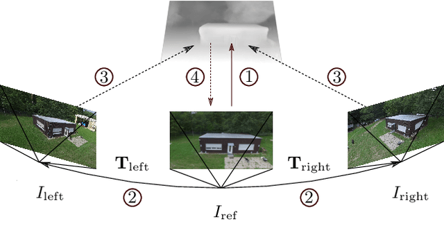

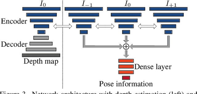
Abstract:Supervised learning based methods for monocular depth estimation usually require large amounts of extensively annotated training data. In the case of aerial imagery, this ground truth is particularly difficult to acquire. Therefore, in this paper, we present a method for self-supervised learning for monocular depth estimation from aerial imagery that does not require annotated training data. For this, we only use an image sequence from a single moving camera and learn to simultaneously estimate depth and pose information. By sharing the weights between pose and depth estimation, we achieve a relatively small model, which favors real-time application. We evaluate our approach on three diverse datasets and compare the results to conventional methods that estimate depth maps based on multi-view geometry. We achieve an accuracy {\delta}1.25 of up to 93.5 %. In addition, we have paid particular attention to the generalization of a trained model to unknown data and the self-improving capabilities of our approach. We conclude that, even though the results of monocular depth estimation are inferior to those achieved by conventional methods, they are well suited to provide a good initialization for methods that rely on image matching or to provide estimates in regions where image matching fails, e.g. occluded or texture-less regions.
Developing a machine learning framework for estimating soil moisture with VNIR hyperspectral data
Jul 12, 2018
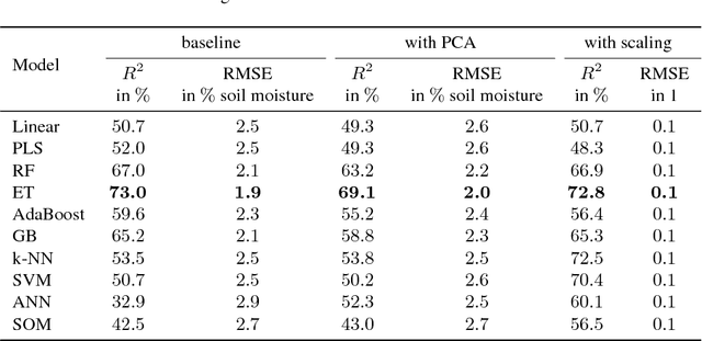
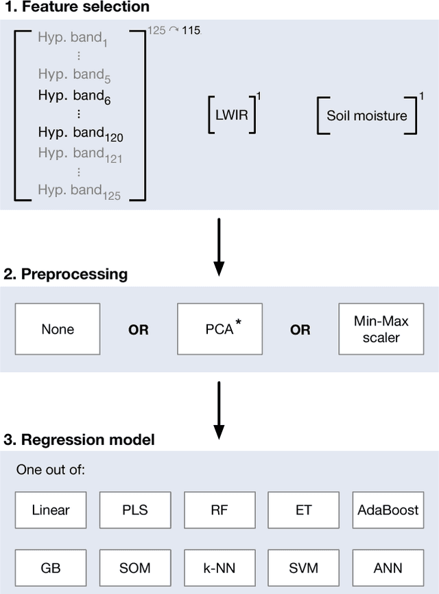
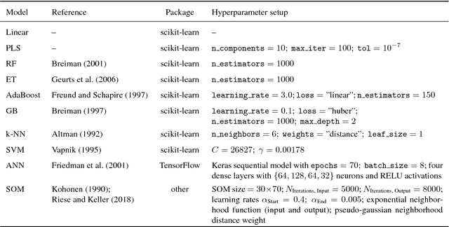
Abstract:In this paper, we investigate the potential of estimating the soil-moisture content based on VNIR hyperspectral data combined with LWIR data. Measurements from a multi-sensor field campaign represent the benchmark dataset which contains measured hyperspectral, LWIR, and soil-moisture data conducted on grassland site. We introduce a regression framework with three steps consisting of feature selection, preprocessing, and well-chosen regression models. The latter are mainly supervised machine learning models. An exception are the self-organizing maps which combine unsupervised and supervised learning. We analyze the impact of the distinct preprocessing methods on the regression results. Of all regression models, the extremely randomized trees model without preprocessing provides the best estimation performance. Our results reveal the potential of the respective regression framework combined with the VNIR hyperspectral data to estimate soil moisture measured under real-world conditions. In conclusion, the results of this paper provide a basis for further improvements in different research directions.
* Accepted at ISPRS TC I Midterm Symposium Karlsruhe (October 2018)
mdBrief - A Fast Online Adaptable, Distorted Binary Descriptor for Real-Time Applications Using Calibrated Wide-Angle Or Fisheye Cameras
Oct 25, 2016
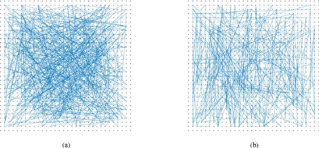

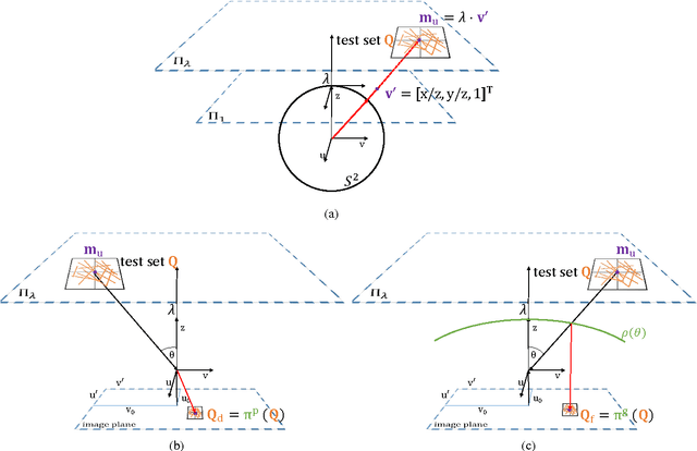
Abstract:Fast binary descriptors build the core for many vision based applications with real-time demands like object detection, Visual Odometry or SLAM. Commonly it is assumed, that the acquired images and thus the patches extracted around keypoints originate from a perspective projection ignoring image distortion or completely different types of projections such as omnidirectional or fisheye. Usually the deviations from a perfect perspective projection are corrected by undistortion. Latter, however, introduces severe artifacts if the cameras field-of-view gets larger. In this paper, we propose a distorted and masked version of the BRIEF descriptor for calibrated cameras. Instead of correcting the distortion holistically, we distort the binary tests and thus adapt the descriptor to different image regions.
MultiCol-SLAM - A Modular Real-Time Multi-Camera SLAM System
Oct 24, 2016

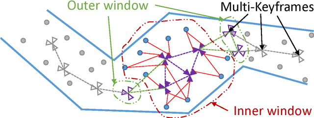
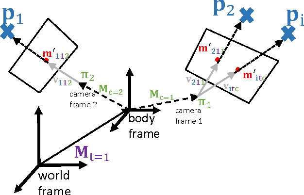
Abstract:The basis for most vision based applications like robotics, self-driving cars and potentially augmented and virtual reality is a robust, continuous estimation of the position and orientation of a camera system w.r.t the observed environment (scene). In recent years many vision based systems that perform simultaneous localization and mapping (SLAM) have been presented and released as open source. In this paper, we extend and improve upon a state-of-the-art SLAM to make it applicable to arbitrary, rigidly coupled multi-camera systems (MCS) using the MultiCol model. In addition, we include a performance evaluation on accurate ground truth and compare the robustness of the proposed method to a single camera version of the SLAM system. An open source implementation of the proposed multi-fisheye camera SLAM system can be found on-line https://github.com/urbste/MultiCol-SLAM.
MLPnP - A Real-Time Maximum Likelihood Solution to the Perspective-n-Point Problem
Jul 27, 2016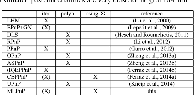
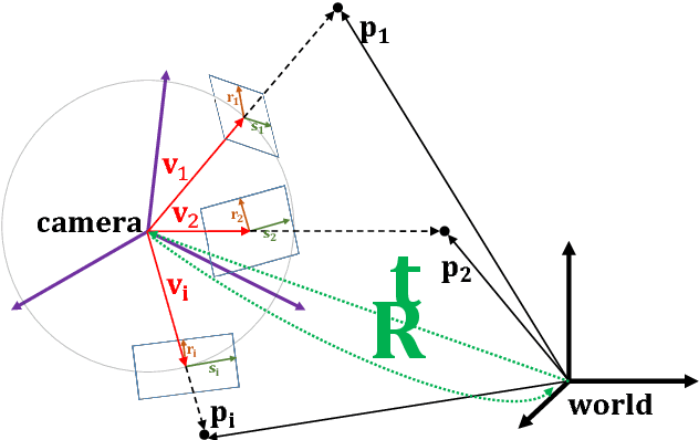


Abstract:In this paper, a statistically optimal solution to the Perspective-n-Point (PnP) problem is presented. Many solutions to the PnP problem are geometrically optimal, but do not consider the uncertainties of the observations. In addition, it would be desirable to have an internal estimation of the accuracy of the estimated rotation and translation parameters of the camera pose. Thus, we propose a novel maximum likelihood solution to the PnP problem, that incorporates image observation uncertainties and remains real-time capable at the same time. Further, the presented method is general, as is works with 3D direction vectors instead of 2D image points and is thus able to cope with arbitrary central camera models. This is achieved by projecting (and thus reducing) the covariance matrices of the observations to the corresponding vector tangent space.
 Add to Chrome
 Add to Firefox
 Add to Edge