Sachith Seneviratne
Flood-LDM: Generalizable Latent Diffusion Models for rapid and accurate zero-shot High-Resolution Flood Mapping
Nov 18, 2025


Abstract:Flood prediction is critical for emergency planning and response to mitigate human and economic losses. Traditional physics-based hydrodynamic models generate high-resolution flood maps using numerical methods requiring fine-grid discretization; which are computationally intensive and impractical for real-time large-scale applications. While recent studies have applied convolutional neural networks for flood map super-resolution with good accuracy and speed, they suffer from limited generalizability to unseen areas. In this paper, we propose a novel approach that leverages latent diffusion models to perform super-resolution on coarse-grid flood maps, with the objective of achieving the accuracy of fine-grid flood maps while significantly reducing inference time. Experimental results demonstrate that latent diffusion models substantially decrease the computational time required to produce high-fidelity flood maps without compromising on accuracy, enabling their use in real-time flood risk management. Moreover, diffusion models exhibit superior generalizability across different physical locations, with transfer learning further accelerating adaptation to new geographic regions. Our approach also incorporates physics-informed inputs, addressing the common limitation of black-box behavior in machine learning, thereby enhancing interpretability. Code is available at https://github.com/neosunhan/flood-diff.
Arch-LLM: Taming LLMs for Neural Architecture Generation via Unsupervised Discrete Representation Learning
Mar 28, 2025Abstract:Unsupervised representation learning has been widely explored across various modalities, including neural architectures, where it plays a key role in downstream applications like Neural Architecture Search (NAS). These methods typically learn an unsupervised representation space before generating/ sampling architectures for the downstream search. A common approach involves the use of Variational Autoencoders (VAEs) to map discrete architectures onto a continuous representation space, however, sampling from these spaces often leads to a high percentage of invalid or duplicate neural architectures. This could be due to the unnatural mapping of inherently discrete architectural space onto a continuous space, which emphasizes the need for a robust discrete representation of these architectures. To address this, we introduce a Vector Quantized Variational Autoencoder (VQ-VAE) to learn a discrete latent space more naturally aligned with the discrete neural architectures. In contrast to VAEs, VQ-VAEs (i) map each architecture into a discrete code sequence and (ii) allow the prior to be learned by any generative model rather than assuming a normal distribution. We then represent these architecture latent codes as numerical sequences and train a text-to-text model leveraging a Large Language Model to learn and generate sequences representing architectures. We experiment our method with Inception/ ResNet-like cell-based search spaces, namely NAS-Bench-101 and NAS-Bench-201. Compared to VAE-based methods, our approach improves the generation of valid and unique architectures by over 80% on NASBench-101 and over 8% on NASBench-201. Finally, we demonstrate the applicability of our method in NAS employing a sequence-modeling-based NAS algorithm.
Unmasking the Unknown: Facial Deepfake Detection in the Open-Set Paradigm
Mar 11, 2025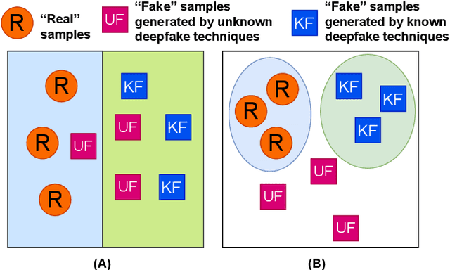
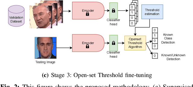
Abstract:Facial forgery methods such as deepfakes can be misused for identity manipulation and spreading misinformation. They have evolved alongside advancements in generative AI, leading to new and more sophisticated forgery techniques that diverge from existing 'known' methods. Conventional deepfake detection methods use the closedset paradigm, thus limiting their applicability to detecting forgeries created using methods that are not part of the training dataset. In this paper, we propose a shift from the closed-set paradigm for deepfake detection. In the open-set paradigm, models are designed not only to identify images created by known facial forgery methods but also to identify and flag those produced by previously unknown methods as 'unknown' and not as unforged/real/unmanipulated. In this paper, we propose an open-set deepfake classification algorithm based on supervised contrastive learning. The open-set paradigm used in our model allows it to function as a more robust tool capable of handling emerging and unseen deepfake techniques, enhancing reliability and confidence, and complementing forensic analysis. In open-set paradigm, we identify three groups including the "unknown group that is neither considered known deepfake nor real. We investigate deepfake open-set classification across three scenarios, classifying deepfakes from unknown methods not as real, distinguishing real images from deepfakes, and classifying deepfakes from known methods, using the FaceForensics++ dataset as a benchmark. Our method achieves state of the art results in the first two tasks and competitive results in the third task.
SphOR: A Representation Learning Perspective on Open-set Recognition for Identifying Unknown Classes in Deep Learning Models
Mar 11, 2025Abstract:The widespread use of deep learning classifiers necessitates Open-set recognition (OSR), which enables the identification of input data not only from classes known during training but also from unknown classes that might be present in test data. Many existing OSR methods are computationally expensive due to the reliance on complex generative models or suffer from high training costs. We investigate OSR from a representation-learning perspective, specifically through spherical embeddings. We introduce SphOR, a computationally efficient representation learning method that models the feature space as a mixture of von Mises-Fisher distributions. This approach enables the use of semantically ambiguous samples during training, to improve the detection of samples from unknown classes. We further explore the relationship between OSR performance and key representation learning properties which influence how well features are structured in high-dimensional space. Extensive experiments on multiple OSR benchmarks demonstrate the effectiveness of our method, producing state-of-the-art results, with improvements up-to 6% that validate its performance.
TT-MPD: Test Time Model Pruning and Distillation
Dec 10, 2024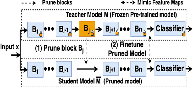


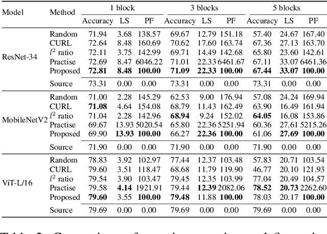
Abstract:Pruning can be an effective method of compressing large pre-trained models for inference speed acceleration. Previous pruning approaches rely on access to the original training dataset for both pruning and subsequent fine-tuning. However, access to the training data can be limited due to concerns such as data privacy and commercial confidentiality. Furthermore, with covariate shift (disparities between test and training data distributions), pruning and finetuning with training datasets can hinder the generalization of the pruned model to test data. To address these issues, pruning and finetuning the model with test time samples becomes essential. However, test-time model pruning and fine-tuning incur additional computation costs and slow down the model's prediction speed, thus posing efficiency issues. Existing pruning methods are not efficient enough for test time model pruning setting, since finetuning the pruned model is needed to evaluate the importance of removable components. To address this, we propose two variables to approximate the fine-tuned accuracy. We then introduce an efficient pruning method that considers the approximated finetuned accuracy and potential inference latency saving. To enhance fine-tuning efficiency, we propose an efficient knowledge distillation method that only needs to generate pseudo labels for a small set of finetuning samples one time, thereby reducing the expensive pseudo-label generation cost. Experimental results demonstrate that our method achieves a comparable or superior tradeoff between test accuracy and inference latency, with a 32% relative reduction in pruning and finetuning time compared to the best existing method.
Rethinking Time Series Forecasting with LLMs via Nearest Neighbor Contrastive Learning
Dec 06, 2024


Abstract:Adapting Large Language Models (LLMs) that are extensively trained on abundant text data, and customizing the input prompt to enable time series forecasting has received considerable attention. While recent work has shown great potential for adapting the learned prior of LLMs, the formulation of the prompt to finetune LLMs remains challenging as prompt should be aligned with time series data. Additionally, current approaches do not effectively leverage word token embeddings which embody the rich representation space learned by LLMs. This emphasizes the need for a robust approach to formulate the prompt which utilizes the word token embeddings while effectively representing the characteristics of the time series. To address these challenges, we propose NNCL-TLLM: Nearest Neighbor Contrastive Learning for Time series forecasting via LLMs. First, we generate time series compatible text prototypes such that each text prototype represents both word token embeddings in its neighborhood and time series characteristics via end-to-end finetuning. Next, we draw inspiration from Nearest Neighbor Contrastive Learning to formulate the prompt while obtaining the top-$k$ nearest neighbor time series compatible text prototypes. We then fine-tune the layer normalization and positional embeddings of the LLM, keeping the other layers intact, reducing the trainable parameters and decreasing the computational cost. Our comprehensive experiments demonstrate that NNCL-TLLM outperforms in few-shot forecasting while achieving competitive or superior performance over the state-of-the-art methods in long-term and short-term forecasting tasks.
GINN-KAN: Interpretability pipelining with applications in Physics Informed Neural Networks
Aug 27, 2024Abstract:Neural networks are powerful function approximators, yet their ``black-box" nature often renders them opaque and difficult to interpret. While many post-hoc explanation methods exist, they typically fail to capture the underlying reasoning processes of the networks. A truly interpretable neural network would be trained similarly to conventional models using techniques such as backpropagation, but additionally provide insights into the learned input-output relationships. In this work, we introduce the concept of interpretability pipelineing, to incorporate multiple interpretability techniques to outperform each individual technique. To this end, we first evaluate several architectures that promise such interpretability, with a particular focus on two recent models selected for their potential to incorporate interpretability into standard neural network architectures while still leveraging backpropagation: the Growing Interpretable Neural Network (GINN) and Kolmogorov Arnold Networks (KAN). We analyze the limitations and strengths of each and introduce a novel interpretable neural network GINN-KAN that synthesizes the advantages of both models. When tested on the Feynman symbolic regression benchmark datasets, GINN-KAN outperforms both GINN and KAN. To highlight the capabilities and the generalizability of this approach, we position GINN-KAN as an alternative to conventional black-box networks in Physics-Informed Neural Networks (PINNs). We expect this to have far-reaching implications in the application of deep learning pipelines in the natural sciences. Our experiments with this interpretable PINN on 15 different partial differential equations demonstrate that GINN-KAN augmented PINNs outperform PINNs with black-box networks in solving differential equations and surpass the capabilities of both GINN and KAN.
General algorithm of assigning raster features to vector maps at any resolution or scale
Jul 15, 2024


Abstract:The fusion of multi-source data is essential for a comprehensive analysis of geographic applications. Due to distinct data structures, the fusion process tends to encounter technical difficulties in terms of preservation of the intactness of each source data. Furthermore, a lack of generalized methods is a problem when the method is expected to be applicable in multiple resolutions, sizes, or scales of raster and vector data, to what is being processed. In this study, we propose a general algorithm of assigning features from raster data (concentrations of air pollutants) to vector components (roads represented by edges) in city maps through the iterative construction of virtual layers to expand geolocation from a city centre to boundaries in a 2D projected map. The construction follows the rule of perfect squares with a slight difference depending on the oddness or evenness of the ratio of city size to raster resolution. We demonstrate the algorithm by applying it to assign accurate PM$_{2.5}$ and NO$_{2}$ concentrations to roads in 1692 cities globally for a potential graph-based pollution analysis. This method could pave the way for agile studies on urgent climate issues by providing a generic and efficient method to accurately fuse multiple datasets of varying scales and compositions.
AniFaceDiff: High-Fidelity Face Reenactment via Facial Parametric Conditioned Diffusion Models
Jun 19, 2024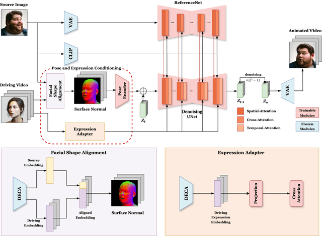
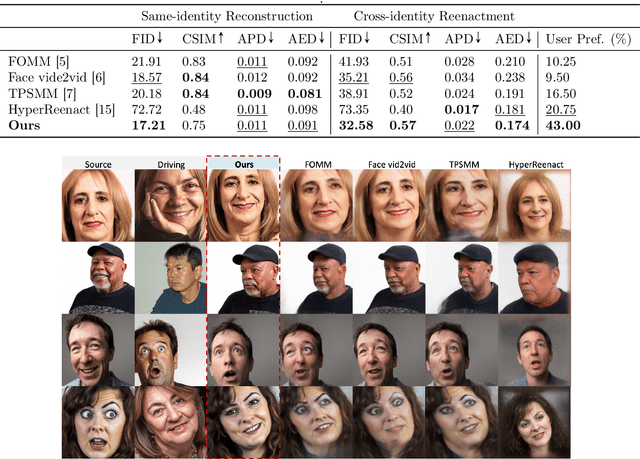
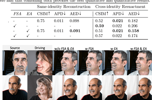
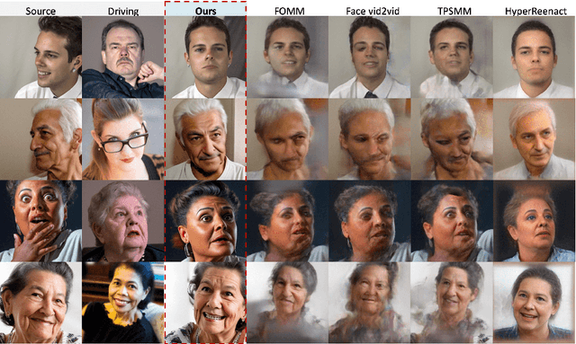
Abstract:Face reenactment refers to the process of transferring the pose and facial expressions from a reference (driving) video onto a static facial (source) image while maintaining the original identity of the source image. Previous research in this domain has made significant progress by training controllable deep generative models to generate faces based on specific identity, pose and expression conditions. However, the mechanisms used in these methods to control pose and expression often inadvertently introduce identity information from the driving video, while also causing a loss of expression-related details. This paper proposes a new method based on Stable Diffusion, called AniFaceDiff, incorporating a new conditioning module for high-fidelity face reenactment. First, we propose an enhanced 2D facial snapshot conditioning approach by facial shape alignment to prevent the inclusion of identity information from the driving video. Then, we introduce an expression adapter conditioning mechanism to address the potential loss of expression-related information. Our approach effectively preserves pose and expression fidelity from the driving video while retaining the identity and fine details of the source image. Through experiments on the VoxCeleb dataset, we demonstrate that our method achieves state-of-the-art results in face reenactment, showcasing superior image quality, identity preservation, and expression accuracy, especially for cross-identity scenarios. Considering the ethical concerns surrounding potential misuse, we analyze the implications of our method, evaluate current state-of-the-art deepfake detectors, and identify their shortcomings to guide future research.
GINN-LP: A Growing Interpretable Neural Network for Discovering Multivariate Laurent Polynomial Equations
Dec 18, 2023
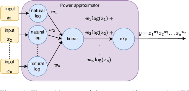


Abstract:Traditional machine learning is generally treated as a black-box optimization problem and does not typically produce interpretable functions that connect inputs and outputs. However, the ability to discover such interpretable functions is desirable. In this work, we propose GINN-LP, an interpretable neural network to discover the form and coefficients of the underlying equation of a dataset, when the equation is assumed to take the form of a multivariate Laurent Polynomial. This is facilitated by a new type of interpretable neural network block, named the "power-term approximator block", consisting of logarithmic and exponential activation functions. GINN-LP is end-to-end differentiable, making it possible to use backpropagation for training. We propose a neural network growth strategy that will enable finding the suitable number of terms in the Laurent polynomial that represents the data, along with sparsity regularization to promote the discovery of concise equations. To the best of our knowledge, this is the first model that can discover arbitrary multivariate Laurent polynomial terms without any prior information on the order. Our approach is first evaluated on a subset of data used in SRBench, a benchmark for symbolic regression. We first show that GINN-LP outperforms the state-of-the-art symbolic regression methods on datasets generated using 48 real-world equations in the form of multivariate Laurent polynomials. Next, we propose an ensemble method that combines our method with a high-performing symbolic regression method, enabling us to discover non-Laurent polynomial equations. We achieve state-of-the-art results in equation discovery, showing an absolute improvement of 7.1% over the best contender, by applying this ensemble method to 113 datasets within SRBench with known ground-truth equations.
 Add to Chrome
 Add to Firefox
 Add to Edge