Marcus White
Leveraging Artificial Intelligence Technology for Mapping Research to Sustainable Development Goals: A Case Study
Nov 09, 2023


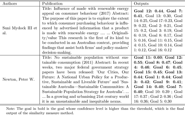
Abstract:The number of publications related to the Sustainable Development Goals (SDGs) continues to grow. These publications cover a diverse spectrum of research, from humanities and social sciences to engineering and health. Given the imperative of funding bodies to monitor outcomes and impacts, linking publications to relevant SDGs is critical but remains time-consuming and difficult given the breadth and complexity of the SDGs. A publication may relate to several goals (interconnection feature of goals), and therefore require multidisciplinary knowledge to tag accurately. Machine learning approaches are promising and have proven particularly valuable for tasks such as manual data labeling and text classification. In this study, we employed over 82,000 publications from an Australian university as a case study. We utilized a similarity measure to map these publications onto Sustainable Development Goals (SDGs). Additionally, we leveraged the OpenAI GPT model to conduct the same task, facilitating a comparative analysis between the two approaches. Experimental results show that about 82.89% of the results obtained by the similarity measure overlap (at least one tag) with the outputs of the GPT model. The adopted model (similarity measure) can complement GPT model for SDG classification. Furthermore, deep learning methods, which include the similarity measure used here, are more accessible and trusted for dealing with sensitive data without the use of commercial AI services or the deployment of expensive computing resources to operate large language models. Our study demonstrates how a crafted combination of the two methods can achieve reliable results for mapping research to the SDGs.
Scalable Label-efficient Footpath Network Generation Using Remote Sensing Data and Self-supervised Learning
Sep 18, 2023


Abstract:Footpath mapping, modeling, and analysis can provide important geospatial insights to many fields of study, including transport, health, environment and urban planning. The availability of robust Geographic Information System (GIS) layers can benefit the management of infrastructure inventories, especially at local government level with urban planners responsible for the deployment and maintenance of such infrastructure. However, many cities still lack real-time information on the location, connectivity, and width of footpaths, and/or employ costly and manual survey means to gather this information. This work designs and implements an automatic pipeline for generating footpath networks based on remote sensing images using machine learning models. The annotation of segmentation tasks, especially labeling remote sensing images with specialized requirements, is very expensive, so we aim to introduce a pipeline requiring less labeled data. Considering supervised methods require large amounts of training data, we use a self-supervised method for feature representation learning to reduce annotation requirements. Then the pre-trained model is used as the encoder of the U-Net for footpath segmentation. Based on the generated masks, the footpath polygons are extracted and converted to footpath networks which can be loaded and visualized by geographic information systems conveniently. Validation results indicate considerable consistency when compared to manually collected GIS layers. The footpath network generation pipeline proposed in this work is low-cost and extensible, and it can be applied where remote sensing images are available. Github: https://github.com/WennyXY/FootpathSeg.
 Add to Chrome
 Add to Firefox
 Add to Edge