Anqi Joyce Yang
Towards Unsupervised Object Detection From LiDAR Point Clouds
Nov 03, 2023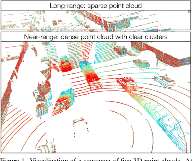

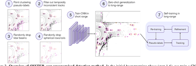

Abstract:In this paper, we study the problem of unsupervised object detection from 3D point clouds in self-driving scenes. We present a simple yet effective method that exploits (i) point clustering in near-range areas where the point clouds are dense, (ii) temporal consistency to filter out noisy unsupervised detections, (iii) translation equivariance of CNNs to extend the auto-labels to long range, and (iv) self-supervision for improving on its own. Our approach, OYSTER (Object Discovery via Spatio-Temporal Refinement), does not impose constraints on data collection (such as repeated traversals of the same location), is able to detect objects in a zero-shot manner without supervised finetuning (even in sparse, distant regions), and continues to self-improve given more rounds of iterative self-training. To better measure model performance in self-driving scenarios, we propose a new planning-centric perception metric based on distance-to-collision. We demonstrate that our unsupervised object detector significantly outperforms unsupervised baselines on PandaSet and Argoverse 2 Sensor dataset, showing promise that self-supervision combined with object priors can enable object discovery in the wild. For more information, visit the project website: https://waabi.ai/research/oyster
CADSim: Robust and Scalable in-the-wild 3D Reconstruction for Controllable Sensor Simulation
Nov 02, 2023Abstract:Realistic simulation is key to enabling safe and scalable development of % self-driving vehicles. A core component is simulating the sensors so that the entire autonomy system can be tested in simulation. Sensor simulation involves modeling traffic participants, such as vehicles, with high quality appearance and articulated geometry, and rendering them in real time. The self-driving industry has typically employed artists to build these assets. However, this is expensive, slow, and may not reflect reality. Instead, reconstructing assets automatically from sensor data collected in the wild would provide a better path to generating a diverse and large set with good real-world coverage. Nevertheless, current reconstruction approaches struggle on in-the-wild sensor data, due to its sparsity and noise. To tackle these issues, we present CADSim, which combines part-aware object-class priors via a small set of CAD models with differentiable rendering to automatically reconstruct vehicle geometry, including articulated wheels, with high-quality appearance. Our experiments show our method recovers more accurate shapes from sparse data compared to existing approaches. Importantly, it also trains and renders efficiently. We demonstrate our reconstructed vehicles in several applications, including accurate testing of autonomy perception systems.
LabelFormer: Object Trajectory Refinement for Offboard Perception from LiDAR Point Clouds
Nov 02, 2023


Abstract:A major bottleneck to scaling-up training of self-driving perception systems are the human annotations required for supervision. A promising alternative is to leverage "auto-labelling" offboard perception models that are trained to automatically generate annotations from raw LiDAR point clouds at a fraction of the cost. Auto-labels are most commonly generated via a two-stage approach -- first objects are detected and tracked over time, and then each object trajectory is passed to a learned refinement model to improve accuracy. Since existing refinement models are overly complex and lack advanced temporal reasoning capabilities, in this work we propose LabelFormer, a simple, efficient, and effective trajectory-level refinement approach. Our approach first encodes each frame's observations separately, then exploits self-attention to reason about the trajectory with full temporal context, and finally decodes the refined object size and per-frame poses. Evaluation on both urban and highway datasets demonstrates that LabelFormer outperforms existing works by a large margin. Finally, we show that training on a dataset augmented with auto-labels generated by our method leads to improved downstream detection performance compared to existing methods. Please visit the project website for details https://waabi.ai/labelformer
* 20 pages, 8 figures, 7 tables
UniSim: A Neural Closed-Loop Sensor Simulator
Aug 03, 2023


Abstract:Rigorously testing autonomy systems is essential for making safe self-driving vehicles (SDV) a reality. It requires one to generate safety critical scenarios beyond what can be collected safely in the world, as many scenarios happen rarely on public roads. To accurately evaluate performance, we need to test the SDV on these scenarios in closed-loop, where the SDV and other actors interact with each other at each timestep. Previously recorded driving logs provide a rich resource to build these new scenarios from, but for closed loop evaluation, we need to modify the sensor data based on the new scene configuration and the SDV's decisions, as actors might be added or removed and the trajectories of existing actors and the SDV will differ from the original log. In this paper, we present UniSim, a neural sensor simulator that takes a single recorded log captured by a sensor-equipped vehicle and converts it into a realistic closed-loop multi-sensor simulation. UniSim builds neural feature grids to reconstruct both the static background and dynamic actors in the scene, and composites them together to simulate LiDAR and camera data at new viewpoints, with actors added or removed and at new placements. To better handle extrapolated views, we incorporate learnable priors for dynamic objects, and leverage a convolutional network to complete unseen regions. Our experiments show UniSim can simulate realistic sensor data with small domain gap on downstream tasks. With UniSim, we demonstrate closed-loop evaluation of an autonomy system on safety-critical scenarios as if it were in the real world.
Virtual Correspondence: Humans as a Cue for Extreme-View Geometry
Jun 16, 2022
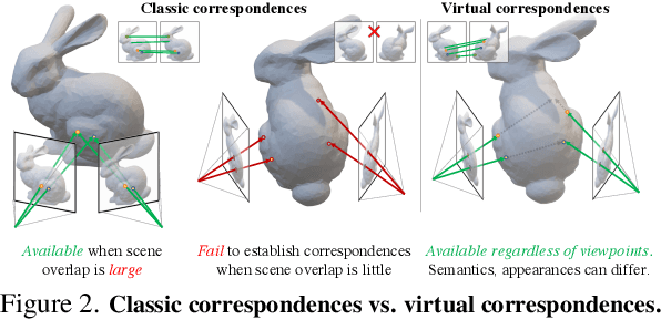


Abstract:Recovering the spatial layout of the cameras and the geometry of the scene from extreme-view images is a longstanding challenge in computer vision. Prevailing 3D reconstruction algorithms often adopt the image matching paradigm and presume that a portion of the scene is co-visible across images, yielding poor performance when there is little overlap among inputs. In contrast, humans can associate visible parts in one image to the corresponding invisible components in another image via prior knowledge of the shapes. Inspired by this fact, we present a novel concept called virtual correspondences (VCs). VCs are a pair of pixels from two images whose camera rays intersect in 3D. Similar to classic correspondences, VCs conform with epipolar geometry; unlike classic correspondences, VCs do not need to be co-visible across views. Therefore VCs can be established and exploited even if images do not overlap. We introduce a method to find virtual correspondences based on humans in the scene. We showcase how VCs can be seamlessly integrated with classic bundle adjustment to recover camera poses across extreme views. Experiments show that our method significantly outperforms state-of-the-art camera pose estimation methods in challenging scenarios and is comparable in the traditional densely captured setup. Our approach also unleashes the potential of multiple downstream tasks such as scene reconstruction from multi-view stereo and novel view synthesis in extreme-view scenarios.
Asynchronous Multi-View SLAM
Jan 17, 2021
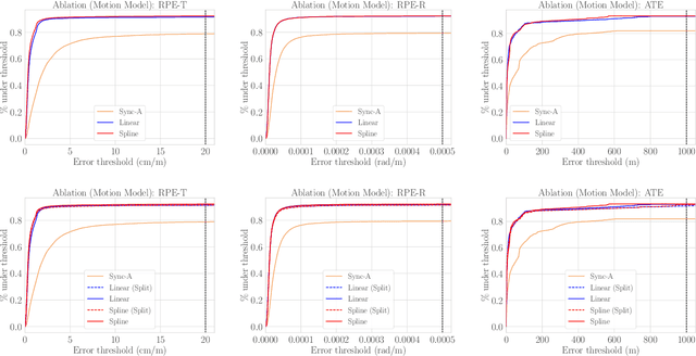
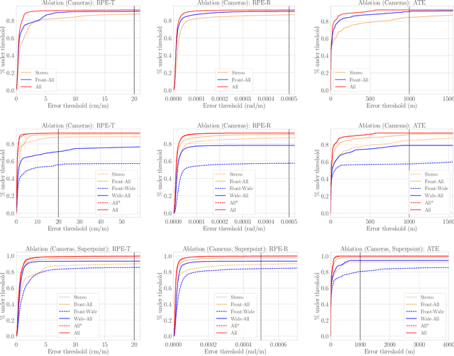
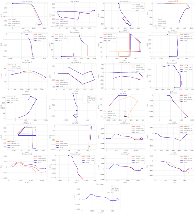
Abstract:Existing multi-camera SLAM systems assume synchronized shutters for all cameras, which is often not the case in practice. In this work, we propose a generalized multi-camera SLAM formulation which accounts for asynchronous sensor observations. Our framework integrates a continuous-time motion model to relate information across asynchronous multi-frames during tracking, local mapping, and loop closing. For evaluation, we collected AMV-Bench, a challenging new SLAM dataset covering 482 km of driving recorded using our asynchronous multi-camera robotic platform. AMV-Bench is over an order of magnitude larger than previous multi-view HD outdoor SLAM datasets, and covers diverse and challenging motions and environments. Our experiments emphasize the necessity of asynchronous sensor modeling, and show that the use of multiple cameras is critical towards robust and accurate SLAM in challenging outdoor scenes.
 Add to Chrome
 Add to Firefox
 Add to Edge