Levente Klein
Fine-tuning of Geospatial Foundation Models for Aboveground Biomass Estimation
Jun 28, 2024


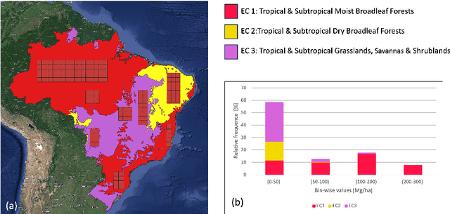
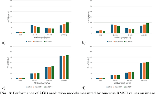
Abstract:Global vegetation structure mapping is critical for understanding the global carbon cycle and maximizing the efficacy of nature-based carbon sequestration initiatives. Moreover, vegetation structure mapping can help reduce the impacts of climate change by, for example, guiding actions to improve water security, increase biodiversity and reduce flood risk. Global satellite measurements provide an important set of observations for monitoring and managing deforestation and degradation of existing forests, natural forest regeneration, reforestation, biodiversity restoration, and the implementation of sustainable agricultural practices. In this paper, we explore the effectiveness of fine-tuning of a geospatial foundation model to estimate above-ground biomass (AGB) using space-borne data collected across different eco-regions in Brazil. The fine-tuned model architecture consisted of a Swin-B transformer as the encoder (i.e., backbone) and a single convolutional layer for the decoder head. All results were compared to a U-Net which was trained as the baseline model Experimental results of this sparse-label prediction task demonstrate that the fine-tuned geospatial foundation model with a frozen encoder has comparable performance to a U-Net trained from scratch. This is despite the fine-tuned model having 13 times less parameters requiring optimization, which saves both time and compute resources. Further, we explore the transfer-learning capabilities of the geospatial foundation models by fine-tuning on satellite imagery with sparse labels from different eco-regions in Brazil.
A 3D super-resolution of wind fields via physics-informed pixel-wise self-attention generative adversarial network
Dec 20, 2023Abstract:To mitigate global warming, greenhouse gas sources need to be resolved at a high spatial resolution and monitored in time to ensure the reduction and ultimately elimination of the pollution source. However, the complexity of computation in resolving high-resolution wind fields left the simulations impractical to test different time lengths and model configurations. This study presents a preliminary development of a physics-informed super-resolution (SR) generative adversarial network (GAN) that super-resolves the three-dimensional (3D) low-resolution wind fields by upscaling x9 times. We develop a pixel-wise self-attention (PWA) module that learns 3D weather dynamics via a self-attention computation followed by a 2D convolution. We also employ a loss term that regularizes the self-attention map during pretraining, capturing the vertical convection process from input wind data. The new PWA SR-GAN shows the high-fidelity super-resolved 3D wind data, learns a wind structure at the high-frequency domain, and reduces the computational cost of a high-resolution wind simulation by x89.7 times.
Image-Based Soil Organic Carbon Remote Sensing from Satellite Images with Fourier Neural Operator and Structural Similarity
Nov 21, 2023

Abstract:Soil organic carbon (SOC) sequestration is the transfer and storage of atmospheric carbon dioxide in soils, which plays an important role in climate change mitigation. SOC concentration can be improved by proper land use, thus it is beneficial if SOC can be estimated at a regional or global scale. As multispectral satellite data can provide SOC-related information such as vegetation and soil properties at a global scale, estimation of SOC through satellite data has been explored as an alternative to manual soil sampling. Although existing studies show promising results, they are mainly based on pixel-based approaches with traditional machine learning methods, and convolutional neural networks (CNNs) are uncommon. To study the use of CNNs on SOC remote sensing, here we propose the FNO-DenseNet based on the Fourier neural operator (FNO). By combining the advantages of the FNO and DenseNet, the FNO-DenseNet outperformed the FNO in our experiments with hundreds of times fewer parameters. The FNO-DenseNet also outperformed a pixel-based random forest by 18% in the mean absolute percentage error.
Multi-task Learning for Source Attribution and Field Reconstruction for Methane Monitoring
Nov 02, 2022Abstract:Inferring the source information of greenhouse gases, such as methane, from spatially sparse sensor observations is an essential element in mitigating climate change. While it is well understood that the complex behavior of the atmospheric dispersion of such pollutants is governed by the Advection-Diffusion equation, it is difficult to directly apply the governing equations to identify the source location and magnitude (inverse problem) because of the spatially sparse and noisy observations, i.e., the pollution concentration is known only at the sensor locations and sensors sensitivity is limited. Here, we develop a multi-task learning framework that can provide high-fidelity reconstruction of the concentration field and identify emission characteristics of the pollution sources such as their location, emission strength, etc. from sparse sensor observations. We demonstrate that our proposed framework is able to achieve accurate reconstruction of the methane concentrations from sparse sensor measurements as well as precisely pin-point the location and emission strength of these pollution sources.
Monitoring Urban Forests from Auto-Generated Segmentation Maps
Jun 14, 2022


Abstract:We present and evaluate a weakly-supervised methodology to quantify the spatio-temporal distribution of urban forests based on remotely sensed data with close-to-zero human interaction. Successfully training machine learning models for semantic segmentation typically depends on the availability of high-quality labels. We evaluate the benefit of high-resolution, three-dimensional point cloud data (LiDAR) as source of noisy labels in order to train models for the localization of trees in orthophotos. As proof of concept we sense Hurricane Sandy's impact on urban forests in Coney Island, New York City (NYC) and reference it to less impacted urban space in Brooklyn, NYC.
Quantification of Carbon Sequestration in Urban Forests
Jun 01, 2021


Abstract:Vegetation, trees in particular, sequester carbon by absorbing carbon dioxide from the atmosphere, however, the lack of efficient quantification methods of carbon stored in trees renders it difficult to track the process. Here we present an approach to estimate the carbon storage in trees based on fusing multispectral aerial imagery and LiDAR data to identify tree coverage, geometric shape, and tree species, which are crucial attributes in carbon storage quantification. We demonstrate that tree species information and their three-dimensional geometric shapes can be estimated from remote imagery in order to calculate the tree's biomass. Specifically, for Manhattan, New York City, we estimate a total of $52,000$ tons of carbon sequestered in trees.
Monitoring the Impact of Wildfires on Tree Species with Deep Learning
Nov 12, 2020


Abstract:One of the impacts of climate change is the difficulty of tree regrowth after wildfires over areas that traditionally were covered by certain tree species. Here a deep learning model is customized to classify land covers from four-band aerial imagery before and after wildfires to study the prolonged consequences of wildfires on tree species. The tree species labels are generated from manually delineated maps for five land cover classes: Conifer, Hardwood, Shrub, ReforestedTree and Barren land. With an accuracy of $92\%$ on the test split, the model is applied to three wildfires on data from 2009 to 2018. The model accurately delineates areas damaged by wildfires, changes in tree species and rebound of burned areas. The result shows clear evidence of wildfires impacting the local ecosystem and the outlined approach can help monitor reforested areas, observe changes in forest composition and track wildfire impact on tree species.
Physics-Informed Neural Network Super Resolution for Advection-Diffusion Models
Nov 04, 2020


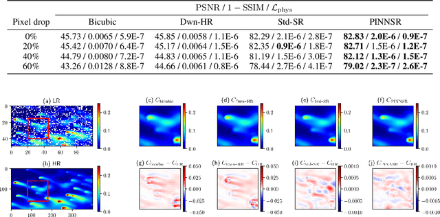
Abstract:Physics-informed neural networks (NN) are an emerging technique to improve spatial resolution and enforce physical consistency of data from physics models or satellite observations. A super-resolution (SR) technique is explored to reconstruct high-resolution images ($4\times$) from lower resolution images in an advection-diffusion model of atmospheric pollution plumes. SR performance is generally increased when the advection-diffusion equation constrains the NN in addition to conventional pixel-based constraints. The ability of SR techniques to also reconstruct missing data is investigated by randomly removing image pixels from the simulations and allowing the system to learn the content of missing data. Improvements in S/N of $11\%$ are demonstrated when physics equations are included in SR with $40\%$ pixel loss. Physics-informed NNs accurately reconstruct corrupted images and generate better results compared to the standard SR approaches.
 Add to Chrome
 Add to Firefox
 Add to Edge