Carlos Gomes
Steve
TerraTorch: The Geospatial Foundation Models Toolkit
Mar 26, 2025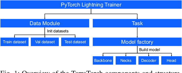
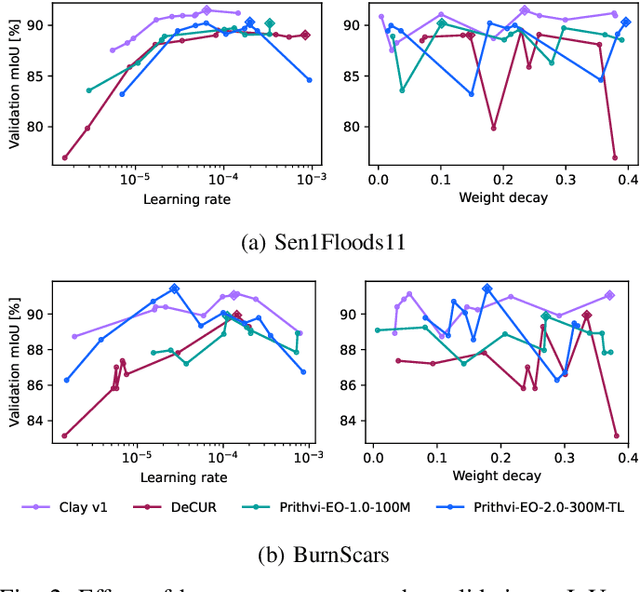


Abstract:TerraTorch is a fine-tuning and benchmarking toolkit for Geospatial Foundation Models built on PyTorch Lightning and tailored for satellite, weather, and climate data. It integrates domain-specific data modules, pre-defined tasks, and a modular model factory that pairs any backbone with diverse decoder heads. These components allow researchers and practitioners to fine-tune supported models in a no-code fashion by simply editing a training configuration. By consolidating best practices for model development and incorporating the automated hyperparameter optimization extension Iterate, TerraTorch reduces the expertise and time required to fine-tune or benchmark models on new Earth Observation use cases. Furthermore, TerraTorch directly integrates with GEO-Bench, allowing for systematic and reproducible benchmarking of Geospatial Foundation Models. TerraTorch is open sourced under Apache 2.0, available at https://github.com/IBM/terratorch, and can be installed via pip install terratorch.
Lossy Neural Compression for Geospatial Analytics: A Review
Mar 03, 2025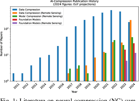
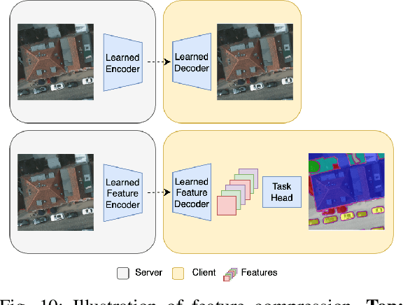

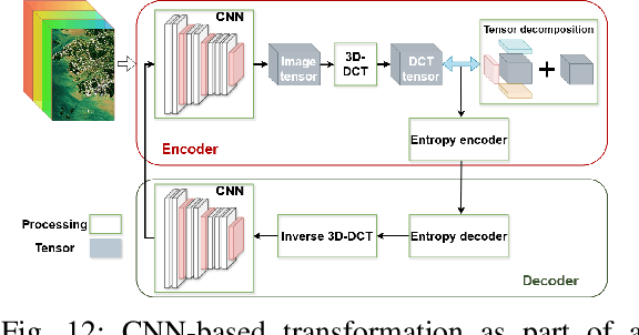
Abstract:Over the past decades, there has been an explosion in the amount of available Earth Observation (EO) data. The unprecedented coverage of the Earth's surface and atmosphere by satellite imagery has resulted in large volumes of data that must be transmitted to ground stations, stored in data centers, and distributed to end users. Modern Earth System Models (ESMs) face similar challenges, operating at high spatial and temporal resolutions, producing petabytes of data per simulated day. Data compression has gained relevance over the past decade, with neural compression (NC) emerging from deep learning and information theory, making EO data and ESM outputs ideal candidates due to their abundance of unlabeled data. In this review, we outline recent developments in NC applied to geospatial data. We introduce the fundamental concepts of NC including seminal works in its traditional applications to image and video compression domains with focus on lossy compression. We discuss the unique characteristics of EO and ESM data, contrasting them with "natural images", and explain the additional challenges and opportunities they present. Moreover, we review current applications of NC across various EO modalities and explore the limited efforts in ESM compression to date. The advent of self-supervised learning (SSL) and foundation models (FM) has advanced methods to efficiently distill representations from vast unlabeled data. We connect these developments to NC for EO, highlighting the similarities between the two fields and elaborate on the potential of transferring compressed feature representations for machine--to--machine communication. Based on insights drawn from this review, we devise future directions relevant to applications in EO and ESM.
Fine-tuning of Geospatial Foundation Models for Aboveground Biomass Estimation
Jun 28, 2024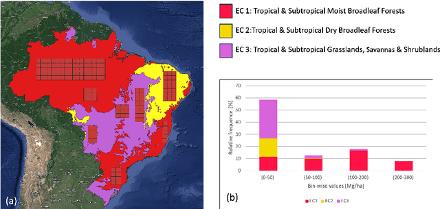

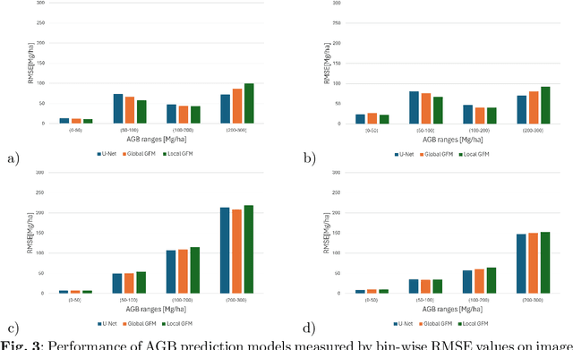
Abstract:Global vegetation structure mapping is critical for understanding the global carbon cycle and maximizing the efficacy of nature-based carbon sequestration initiatives. Moreover, vegetation structure mapping can help reduce the impacts of climate change by, for example, guiding actions to improve water security, increase biodiversity and reduce flood risk. Global satellite measurements provide an important set of observations for monitoring and managing deforestation and degradation of existing forests, natural forest regeneration, reforestation, biodiversity restoration, and the implementation of sustainable agricultural practices. In this paper, we explore the effectiveness of fine-tuning of a geospatial foundation model to estimate above-ground biomass (AGB) using space-borne data collected across different eco-regions in Brazil. The fine-tuned model architecture consisted of a Swin-B transformer as the encoder (i.e., backbone) and a single convolutional layer for the decoder head. All results were compared to a U-Net which was trained as the baseline model Experimental results of this sparse-label prediction task demonstrate that the fine-tuned geospatial foundation model with a frozen encoder has comparable performance to a U-Net trained from scratch. This is despite the fine-tuned model having 13 times less parameters requiring optimization, which saves both time and compute resources. Further, we explore the transfer-learning capabilities of the geospatial foundation models by fine-tuning on satellite imagery with sparse labels from different eco-regions in Brazil.
Neural Embedding Compression For Efficient Multi-Task Earth Observation Modelling
Apr 08, 2024


Abstract:As repositories of large scale data in earth observation (EO) have grown, so have transfer and storage costs for model training and inference, expending significant resources. We introduce Neural Embedding Compression (NEC), based on the transfer of compressed embeddings to data consumers instead of raw data. We adapt foundation models (FM) through learned neural compression to generate multi-task embeddings while navigating the tradeoff between compression rate and embedding utility. We update only a small fraction of the FM parameters (10%) for a short training period (1% of the iterations of pre-training). We evaluate NEC on two EO tasks: scene classification and semantic segmentation. Compared with applying traditional compression to the raw data, NEC achieves similar accuracy with a 75% to 90% reduction in data. Even at 99.7% compression, performance drops by only 5% on the scene classification task. Overall, NEC is a data-efficient yet performant approach for multi-task EO modelling.
Foundation Models for Generalist Geospatial Artificial Intelligence
Nov 08, 2023Abstract:Significant progress in the development of highly adaptable and reusable Artificial Intelligence (AI) models is expected to have a significant impact on Earth science and remote sensing. Foundation models are pre-trained on large unlabeled datasets through self-supervision, and then fine-tuned for various downstream tasks with small labeled datasets. This paper introduces a first-of-a-kind framework for the efficient pre-training and fine-tuning of foundational models on extensive geospatial data. We have utilized this framework to create Prithvi, a transformer-based geospatial foundational model pre-trained on more than 1TB of multispectral satellite imagery from the Harmonized Landsat-Sentinel 2 (HLS) dataset. Our study demonstrates the efficacy of our framework in successfully fine-tuning Prithvi to a range of Earth observation tasks that have not been tackled by previous work on foundation models involving multi-temporal cloud gap imputation, flood mapping, wildfire scar segmentation, and multi-temporal crop segmentation. Our experiments show that the pre-trained model accelerates the fine-tuning process compared to leveraging randomly initialized weights. In addition, pre-trained Prithvi compares well against the state-of-the-art, e.g., outperforming a conditional GAN model in multi-temporal cloud imputation by up to 5pp (or 5.7%) in the structural similarity index. Finally, due to the limited availability of labeled data in the field of Earth observation, we gradually reduce the quantity of available labeled data for refining the model to evaluate data efficiency and demonstrate that data can be decreased significantly without affecting the model's accuracy. The pre-trained 100 million parameter model and corresponding fine-tuning workflows have been released publicly as open source contributions to the global Earth sciences community through Hugging Face.
Measuring the False Sense of Security
Apr 10, 2022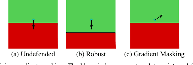

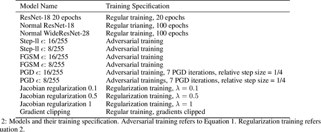

Abstract:Recently, several papers have demonstrated how widespread gradient masking is amongst proposed adversarial defenses. Defenses that rely on this phenomenon are considered failed, and can easily be broken. Despite this, there has been little investigation into ways of measuring the phenomenon of gradient masking and enabling comparisons of its extent amongst different networks. In this work, we investigate gradient masking under the lens of its mensurability, departing from the idea that it is a binary phenomenon. We propose and motivate several metrics for it, performing extensive empirical tests on defenses suspected of exhibiting different degrees of gradient masking. These are computationally cheaper than strong attacks, enable comparisons between models, and do not require the large time investment of tailor-made attacks for specific models. Our results reveal metrics that are successful in measuring the extent of gradient masking across different networks
 Add to Chrome
 Add to Firefox
 Add to Edge