Bianca Zadrozny
Steve
TerraTorch: The Geospatial Foundation Models Toolkit
Mar 26, 2025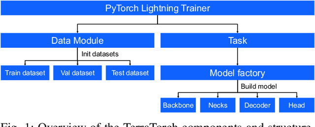


Abstract:TerraTorch is a fine-tuning and benchmarking toolkit for Geospatial Foundation Models built on PyTorch Lightning and tailored for satellite, weather, and climate data. It integrates domain-specific data modules, pre-defined tasks, and a modular model factory that pairs any backbone with diverse decoder heads. These components allow researchers and practitioners to fine-tune supported models in a no-code fashion by simply editing a training configuration. By consolidating best practices for model development and incorporating the automated hyperparameter optimization extension Iterate, TerraTorch reduces the expertise and time required to fine-tune or benchmark models on new Earth Observation use cases. Furthermore, TerraTorch directly integrates with GEO-Bench, allowing for systematic and reproducible benchmarking of Geospatial Foundation Models. TerraTorch is open sourced under Apache 2.0, available at https://github.com/IBM/terratorch, and can be installed via pip install terratorch.
Prithvi-EO-2.0: A Versatile Multi-Temporal Foundation Model for Earth Observation Applications
Dec 03, 2024

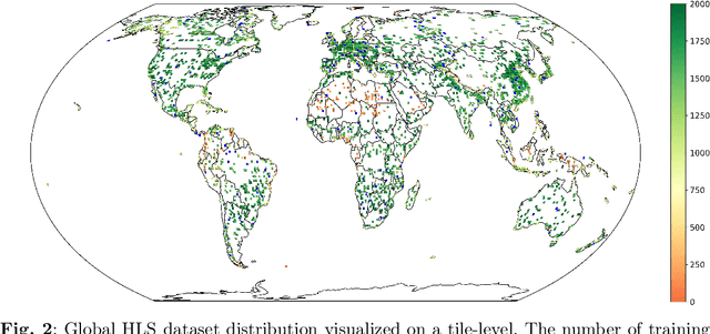
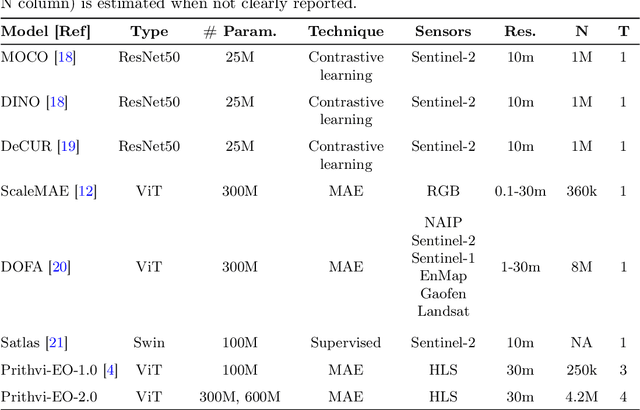
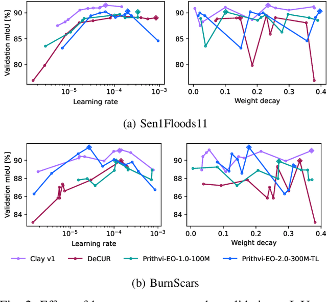
Abstract:This technical report presents Prithvi-EO-2.0, a new geospatial foundation model that offers significant improvements over its predecessor, Prithvi-EO-1.0. Trained on 4.2M global time series samples from NASA's Harmonized Landsat and Sentinel-2 data archive at 30m resolution, the new 300M and 600M parameter models incorporate temporal and location embeddings for enhanced performance across various geospatial tasks. Through extensive benchmarking with GEO-Bench, the 600M version outperforms the previous Prithvi-EO model by 8\% across a range of tasks. It also outperforms six other geospatial foundation models when benchmarked on remote sensing tasks from different domains and resolutions (i.e. from 0.1m to 15m). The results demonstrate the versatility of the model in both classical earth observation and high-resolution applications. Early involvement of end-users and subject matter experts (SMEs) are among the key factors that contributed to the project's success. In particular, SME involvement allowed for constant feedback on model and dataset design, as well as successful customization for diverse SME-led applications in disaster response, land use and crop mapping, and ecosystem dynamics monitoring. Prithvi-EO-2.0 is available on Hugging Face and IBM terratorch, with additional resources on GitHub. The project exemplifies the Trusted Open Science approach embraced by all involved organizations.
Foundation Models for Generalist Geospatial Artificial Intelligence
Nov 08, 2023Abstract:Significant progress in the development of highly adaptable and reusable Artificial Intelligence (AI) models is expected to have a significant impact on Earth science and remote sensing. Foundation models are pre-trained on large unlabeled datasets through self-supervision, and then fine-tuned for various downstream tasks with small labeled datasets. This paper introduces a first-of-a-kind framework for the efficient pre-training and fine-tuning of foundational models on extensive geospatial data. We have utilized this framework to create Prithvi, a transformer-based geospatial foundational model pre-trained on more than 1TB of multispectral satellite imagery from the Harmonized Landsat-Sentinel 2 (HLS) dataset. Our study demonstrates the efficacy of our framework in successfully fine-tuning Prithvi to a range of Earth observation tasks that have not been tackled by previous work on foundation models involving multi-temporal cloud gap imputation, flood mapping, wildfire scar segmentation, and multi-temporal crop segmentation. Our experiments show that the pre-trained model accelerates the fine-tuning process compared to leveraging randomly initialized weights. In addition, pre-trained Prithvi compares well against the state-of-the-art, e.g., outperforming a conditional GAN model in multi-temporal cloud imputation by up to 5pp (or 5.7%) in the structural similarity index. Finally, due to the limited availability of labeled data in the field of Earth observation, we gradually reduce the quantity of available labeled data for refining the model to evaluate data efficiency and demonstrate that data can be decreased significantly without affecting the model's accuracy. The pre-trained 100 million parameter model and corresponding fine-tuning workflows have been released publicly as open source contributions to the global Earth sciences community through Hugging Face.
Wildfire risk forecast: An optimizable fire danger index
Mar 28, 2022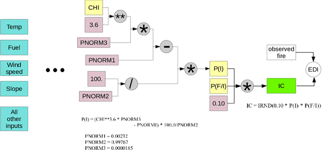
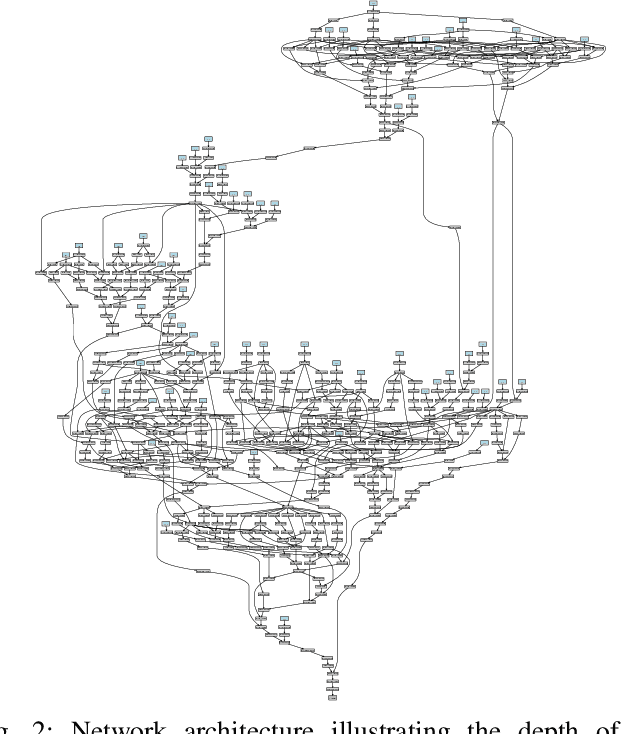
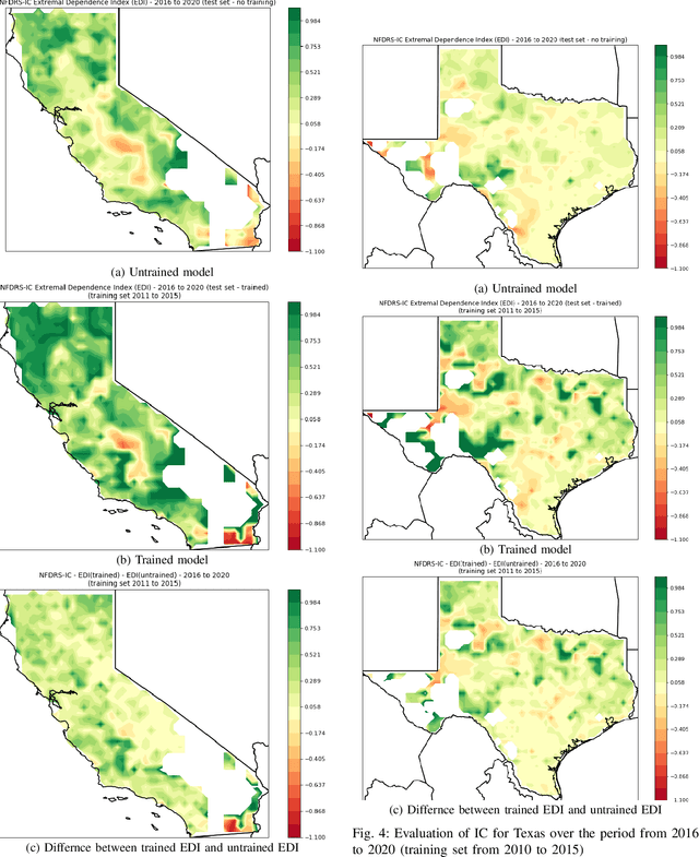
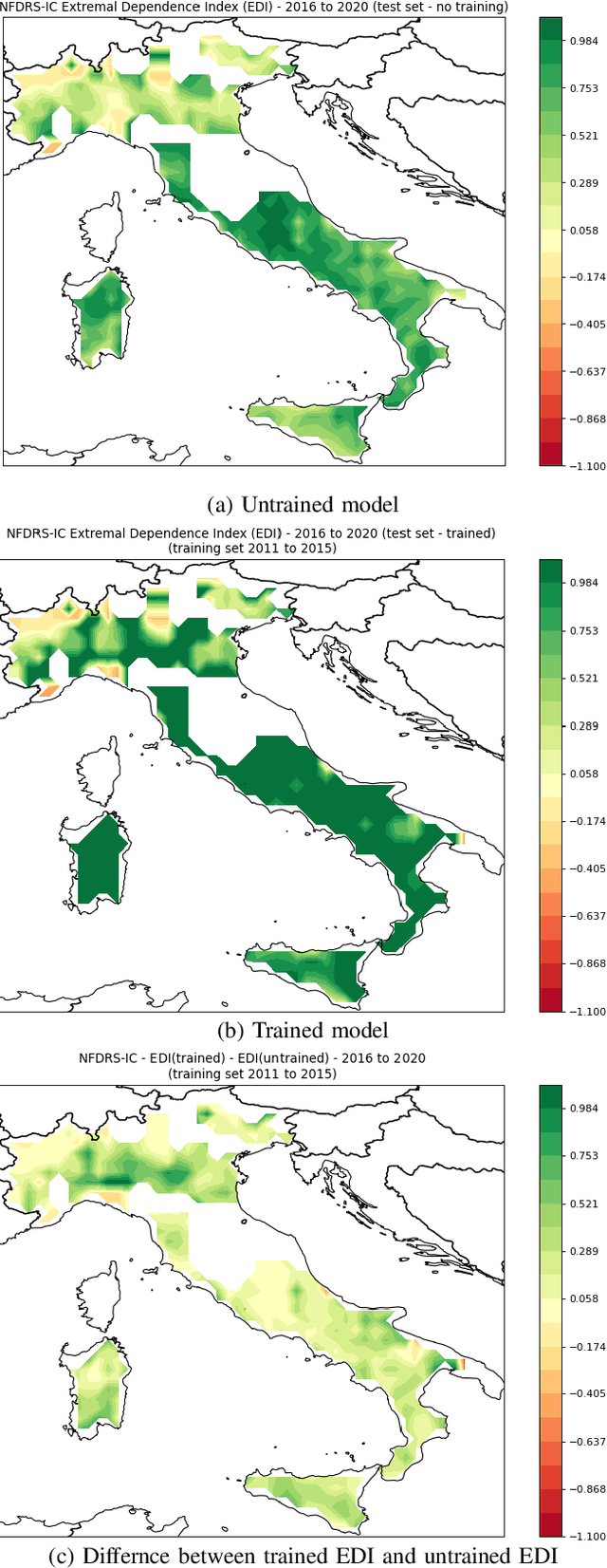
Abstract:Wildfire events have caused severe losses in many places around the world and are expected to increase with climate change. Throughout the years many technologies have been developed to identify fire events early on and to simulate fire behavior once they have started. Another particularly helpful technology is fire risk indices, which use weather forcing to make advanced predictions of the risk of fire. Predictions of fire risk indices can be used, for instance, to allocate resources in places with high risk. These indices have been developed over the years as empirical models with parameters that were estimated in lab experiments and field tests. These parameters, however, may not fit well all places where these models are used. In this paper we propose a novel implementation of one index (NFDRS IC) as a differentiable function in which one can optimize its internal parameters via gradient descent. We leverage existing machine learning frameworks (PyTorch) to construct our model. This approach has two benefits: (1) the NFDRS IC parameters can be improved for each region using actual observed fire events, and (2) the internal variables remain intact for interpretations by specialists instead of meaningless hidden layers as in traditional neural networks. In this paper we evaluate our strategy with actual fire events for locations in the USA and Europe.
Addressing Deep Learning Model Uncertainty in Long-Range Climate Forecasting with Late Fusion
Dec 10, 2021
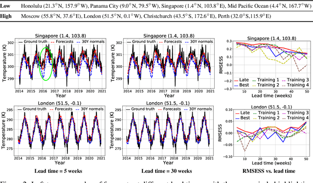


Abstract:Global warming leads to the increase in frequency and intensity of climate extremes that cause tremendous loss of lives and property. Accurate long-range climate prediction allows more time for preparation and disaster risk management for such extreme events. Although machine learning approaches have shown promising results in long-range climate forecasting, the associated model uncertainties may reduce their reliability. To address this issue, we propose a late fusion approach that systematically combines the predictions from multiple models to reduce the expected errors of the fused results. We also propose a network architecture with the novel denormalization layer to gain the benefits of data normalization without actually normalizing the data. The experimental results on long-range 2m temperature forecasting show that the framework outperforms the 30-year climate normals, and the accuracy can be improved by increasing the number of models.
Controlling Weather Field Synthesis Using Variational Autoencoders
Jul 30, 2021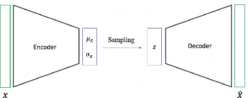
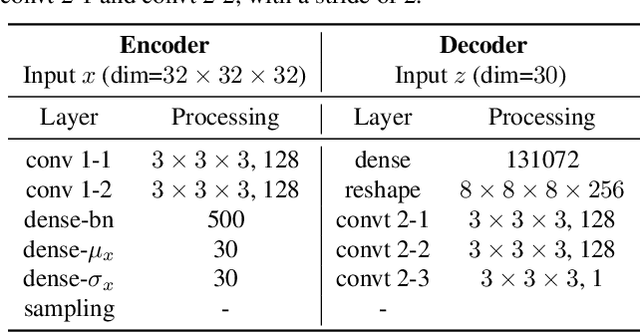
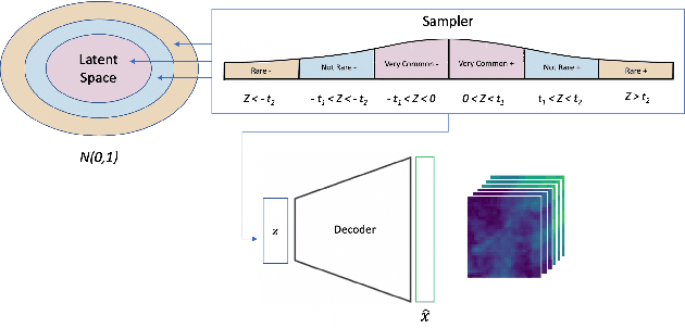
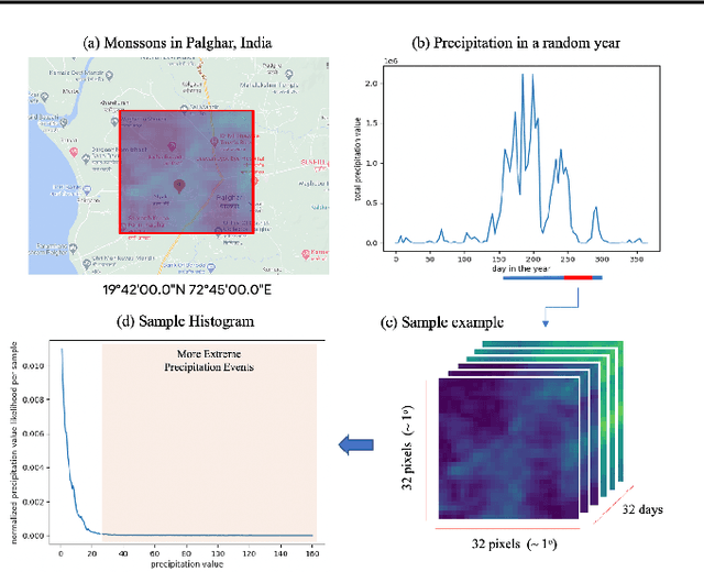
Abstract:One of the consequences of climate change is anobserved increase in the frequency of extreme cli-mate events. That poses a challenge for weatherforecast and generation algorithms, which learnfrom historical data but should embed an often un-certain bias to create correct scenarios. This paperinvestigates how mapping climate data to a knowndistribution using variational autoencoders mighthelp explore such biases and control the synthesisof weather fields towards more extreme climatescenarios. We experimented using a monsoon-affected precipitation dataset from southwest In-dia, which should give a roughly stable pattern ofrainy days and ease our investigation. We reportcompelling results showing that mapping complexweather data to a known distribution implementsan efficient control for weather field synthesis to-wards more (or less) extreme scenarios.
A comparative study of stochastic and deep generative models for multisite precipitation synthesis
Jul 16, 2021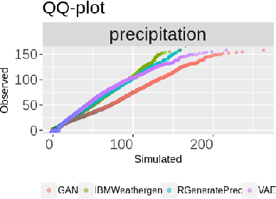


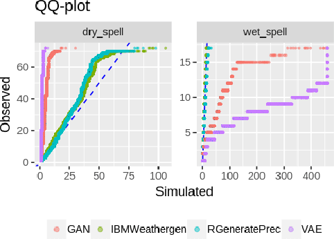
Abstract:Future climate change scenarios are usually hypothesized using simulations from weather generators. However, there only a few works comparing and evaluating promising deep learning models for weather generation against classical approaches. This study shows preliminary results making such evaluations for the multisite precipitation synthesis task. We compared two open-source weather generators: IBMWeathergen (an extension of the Weathergen library) and RGeneratePrec, and two deep generative models: GAN and VAE, on a variety of metrics. Our preliminary results can serve as a guide for improving the design of deep learning architectures and algorithms for the multisite precipitation synthesis task.
Extreme Precipitation Seasonal Forecast Using a Transformer Neural Network
Jul 14, 2021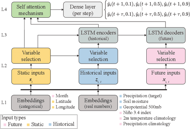
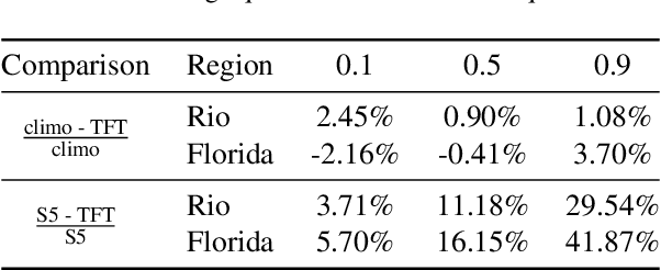
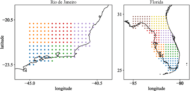
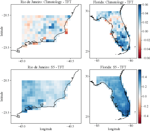
Abstract:An impact of climate change is the increase in frequency and intensity of extreme precipitation events. However, confidently predicting the likelihood of extreme precipitation at seasonal scales remains an outstanding challenge. Here, we present an approach to forecasting the quantiles of the maximum daily precipitation in each week up to six months ahead using the temporal fusion transformer (TFT) model. Through experiments in two regions, we compare TFT predictions with those of two baselines: climatology and a calibrated ECMWF SEAS5 ensemble forecast (S5). Our results show that, in terms of quantile risk at six month lead time, the TFT predictions significantly outperform those from S5 and show an overall small improvement compared to climatology. The TFT also responds positively to departures from normal that climatology cannot.
Decadal Forecasts with ResDMD: a Residual DMD Neural Network
Jun 21, 2021

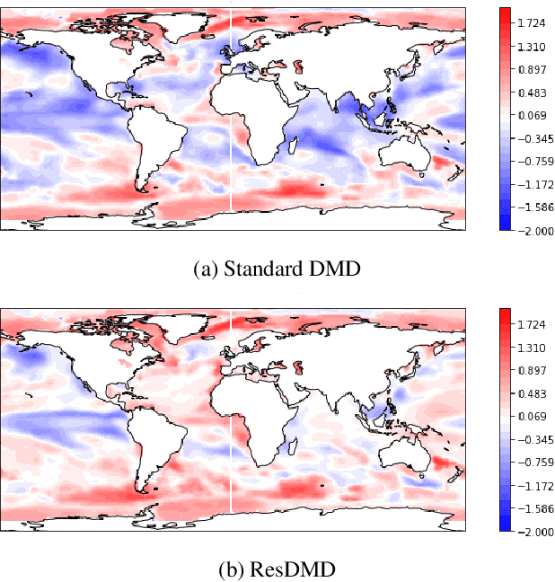

Abstract:Operational forecasting centers are investing in decadal (1-10 year) forecast systems to support long-term decision making for a more climate-resilient society. One method that has previously been employed is the Dynamic Mode Decomposition (DMD) algorithm - also known as the Linear Inverse Model - which fits linear dynamical models to data. While the DMD usually approximates non-linear terms in the true dynamics as a linear system with random noise, we investigate an extension to the DMD that explicitly represents the non-linear terms as a neural network. Our weight initialization allows the network to produce sensible results before training and then improve the prediction after training as data becomes available. In this short paper, we evaluate the proposed architecture for simulating global sea surface temperatures and compare the results with the standard DMD and seasonal forecasts produced by the state-of-the-art dynamical model, CFSv2.
Geostatistical Learning: Challenges and Opportunities
Feb 17, 2021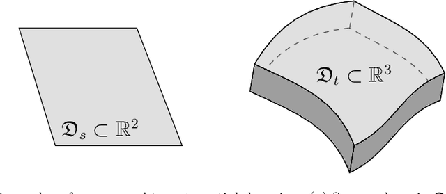

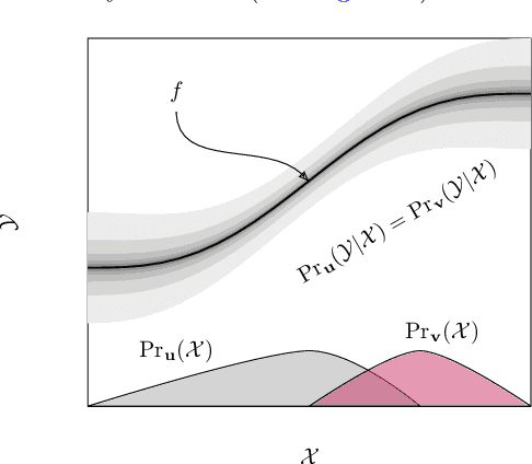

Abstract:Statistical learning theory provides the foundation to applied machine learning, and its various successful applications in computer vision, natural language processing and other scientific domains. The theory, however, does not take into account the unique challenges of performing statistical learning in geospatial settings. For instance, it is well known that model errors cannot be assumed to be independent and identically distributed in geospatial (a.k.a. regionalized) variables due to spatial correlation; and trends caused by geophysical processes lead to covariate shifts between the domain where the model was trained and the domain where it will be applied, which in turn harm the use of classical learning methodologies that rely on random samples of the data. In this work, we introduce the geostatistical (transfer) learning problem, and illustrate the challenges of learning from geospatial data by assessing widely-used methods for estimating generalization error of learning models, under covariate shift and spatial correlation. Experiments with synthetic Gaussian process data as well as with real data from geophysical surveys in New Zealand indicate that none of the methods are adequate for model selection in a geospatial context. We provide general guidelines regarding the choice of these methods in practice while new methods are being actively researched.
 Add to Chrome
 Add to Firefox
 Add to Edge