Denys Godwin
Steve
Prithvi-EO-2.0: A Versatile Multi-Temporal Foundation Model for Earth Observation Applications
Dec 03, 2024


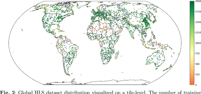
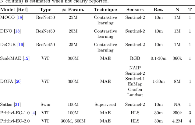
Abstract:This technical report presents Prithvi-EO-2.0, a new geospatial foundation model that offers significant improvements over its predecessor, Prithvi-EO-1.0. Trained on 4.2M global time series samples from NASA's Harmonized Landsat and Sentinel-2 data archive at 30m resolution, the new 300M and 600M parameter models incorporate temporal and location embeddings for enhanced performance across various geospatial tasks. Through extensive benchmarking with GEO-Bench, the 600M version outperforms the previous Prithvi-EO model by 8\% across a range of tasks. It also outperforms six other geospatial foundation models when benchmarked on remote sensing tasks from different domains and resolutions (i.e. from 0.1m to 15m). The results demonstrate the versatility of the model in both classical earth observation and high-resolution applications. Early involvement of end-users and subject matter experts (SMEs) are among the key factors that contributed to the project's success. In particular, SME involvement allowed for constant feedback on model and dataset design, as well as successful customization for diverse SME-led applications in disaster response, land use and crop mapping, and ecosystem dynamics monitoring. Prithvi-EO-2.0 is available on Hugging Face and IBM terratorch, with additional resources on GitHub. The project exemplifies the Trusted Open Science approach embraced by all involved organizations.
Seeing Through the Clouds: Cloud Gap Imputation with Prithvi Foundation Model
Apr 30, 2024


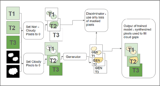
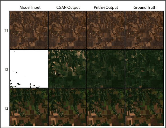
Abstract:Filling cloudy pixels in multispectral satellite imagery is essential for accurate data analysis and downstream applications, especially for tasks which require time series data. To address this issue, we compare the performance of a foundational Vision Transformer (ViT) model with a baseline Conditional Generative Adversarial Network (CGAN) model for missing value imputation in time series of multispectral satellite imagery. We randomly mask time series of satellite images using real-world cloud masks and train each model to reconstruct the missing pixels. The ViT model is fine-tuned from a pretrained model, while the CGAN is trained from scratch. Using quantitative evaluation metrics such as structural similarity index and mean absolute error as well as qualitative visual analysis, we assess imputation accuracy and contextual preservation.
Foundation Models for Generalist Geospatial Artificial Intelligence
Nov 08, 2023Abstract:Significant progress in the development of highly adaptable and reusable Artificial Intelligence (AI) models is expected to have a significant impact on Earth science and remote sensing. Foundation models are pre-trained on large unlabeled datasets through self-supervision, and then fine-tuned for various downstream tasks with small labeled datasets. This paper introduces a first-of-a-kind framework for the efficient pre-training and fine-tuning of foundational models on extensive geospatial data. We have utilized this framework to create Prithvi, a transformer-based geospatial foundational model pre-trained on more than 1TB of multispectral satellite imagery from the Harmonized Landsat-Sentinel 2 (HLS) dataset. Our study demonstrates the efficacy of our framework in successfully fine-tuning Prithvi to a range of Earth observation tasks that have not been tackled by previous work on foundation models involving multi-temporal cloud gap imputation, flood mapping, wildfire scar segmentation, and multi-temporal crop segmentation. Our experiments show that the pre-trained model accelerates the fine-tuning process compared to leveraging randomly initialized weights. In addition, pre-trained Prithvi compares well against the state-of-the-art, e.g., outperforming a conditional GAN model in multi-temporal cloud imputation by up to 5pp (or 5.7%) in the structural similarity index. Finally, due to the limited availability of labeled data in the field of Earth observation, we gradually reduce the quantity of available labeled data for refining the model to evaluate data efficiency and demonstrate that data can be decreased significantly without affecting the model's accuracy. The pre-trained 100 million parameter model and corresponding fine-tuning workflows have been released publicly as open source contributions to the global Earth sciences community through Hugging Face.
 Add to Chrome
 Add to Firefox
 Add to Edge