 Add to Chrome
 Add to Firefox
 Add to Edge
TerraTorch: The Geospatial Foundation Models Toolkit
Mar 26, 2025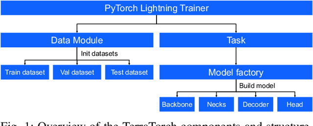

TerraTorch is a fine-tuning and benchmarking toolkit for Geospatial Foundation Models built on PyTorch Lightning and tailored for satellite, weather, and climate data. It integrates domain-specific data modules, pre-defined tasks, and a modular model factory that pairs any backbone with diverse decoder heads. These components allow researchers and practitioners to fine-tune supported models in a no-code fashion by simply editing a training configuration. By consolidating best practices for model development and incorporating the automated hyperparameter optimization extension Iterate, TerraTorch reduces the expertise and time required to fine-tune or benchmark models on new Earth Observation use cases. Furthermore, TerraTorch directly integrates with GEO-Bench, allowing for systematic and reproducible benchmarking of Geospatial Foundation Models. TerraTorch is open sourced under Apache 2.0, available at https://github.com/IBM/terratorch, and can be installed via pip install terratorch.
Multispectral to Hyperspectral using Pretrained Foundational model
Feb 26, 2025
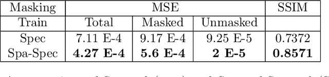
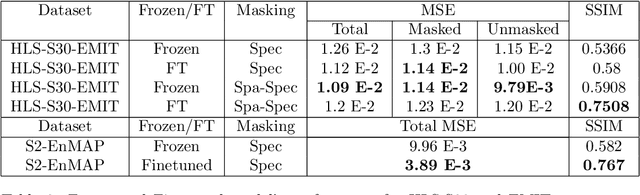
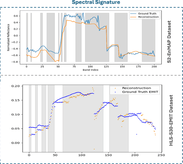
Hyperspectral imaging provides detailed spectral information, offering significant potential for monitoring greenhouse gases like CH4 and NO2. However, its application is constrained by limited spatial coverage and infrequent revisit times. In contrast, multispectral imaging delivers broader spatial and temporal coverage but lacks the spectral granularity required for precise GHG detection. To address these challenges, this study proposes Spectral and Spatial-Spectral transformer models that reconstruct hyperspectral data from multispectral inputs. The models in this paper are pretrained on EnMAP and EMIT datasets and fine-tuned on spatio-temporally aligned (Sentinel-2, EnMAP) and (HLS-S30, EMIT) image pairs respectively. Our model has the potential to enhance atmospheric monitoring by combining the strengths of hyperspectral and multispectral imaging systems.
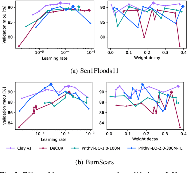
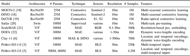
Prithvi-EO-2.0: A Versatile Multi-Temporal Foundation Model for Earth Observation Applications
Dec 03, 2024
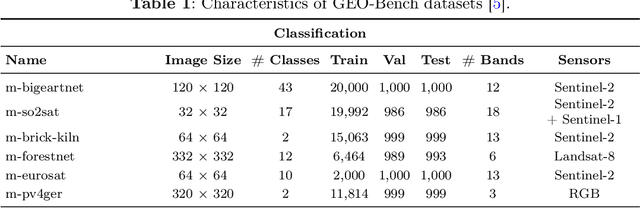
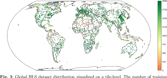
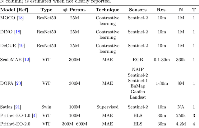
This technical report presents Prithvi-EO-2.0, a new geospatial foundation model that offers significant improvements over its predecessor, Prithvi-EO-1.0. Trained on 4.2M global time series samples from NASA's Harmonized Landsat and Sentinel-2 data archive at 30m resolution, the new 300M and 600M parameter models incorporate temporal and location embeddings for enhanced performance across various geospatial tasks. Through extensive benchmarking with GEO-Bench, the 600M version outperforms the previous Prithvi-EO model by 8\% across a range of tasks. It also outperforms six other geospatial foundation models when benchmarked on remote sensing tasks from different domains and resolutions (i.e. from 0.1m to 15m). The results demonstrate the versatility of the model in both classical earth observation and high-resolution applications. Early involvement of end-users and subject matter experts (SMEs) are among the key factors that contributed to the project's success. In particular, SME involvement allowed for constant feedback on model and dataset design, as well as successful customization for diverse SME-led applications in disaster response, land use and crop mapping, and ecosystem dynamics monitoring. Prithvi-EO-2.0 is available on Hugging Face and IBM terratorch, with additional resources on GitHub. The project exemplifies the Trusted Open Science approach embraced by all involved organizations.