 Add to Chrome
 Add to Firefox
 Add to Edge
TerraMesh: A Planetary Mosaic of Multimodal Earth Observation Data
Apr 15, 2025Large-scale foundation models in Earth Observation can learn versatile, label-efficient representations by leveraging massive amounts of unlabeled data. However, existing public datasets are often limited in scale, geographic coverage, or sensor variety. We introduce TerraMesh, a new globally diverse, multimodal dataset combining optical, synthetic aperture radar, elevation, and land-cover modalities in an Analysis-Ready Data format. TerraMesh includes over 9 million samples with eight spatiotemporal aligned modalities, enabling large-scale pre-training and fostering robust cross-modal correlation learning. We provide detailed data processing steps, comprehensive statistics, and empirical evidence demonstrating improved model performance when pre-trained on TerraMesh. The dataset will be made publicly available with a permissive license.
TerraMind: Large-Scale Generative Multimodality for Earth Observation
Apr 15, 2025


We present TerraMind, the first any-to-any generative, multimodal foundation model for Earth observation (EO). Unlike other multimodal models, TerraMind is pretrained on dual-scale representations combining both token-level and pixel-level data across modalities. On a token level, TerraMind encodes high-level contextual information to learn cross-modal relationships, while on a pixel level, TerraMind leverages fine-grained representations to capture critical spatial nuances. We pretrained TerraMind on nine geospatial modalities of a global, large-scale dataset. In this paper, we demonstrate that (i) TerraMind's dual-scale early fusion approach unlocks a range of zero-shot and few-shot applications for Earth observation, (ii) TerraMind introduces "Thinking-in-Modalities" (TiM) -- the capability of generating additional artificial data during finetuning and inference to improve the model output -- and (iii) TerraMind achieves beyond state-of-the-art performance in community-standard benchmarks for EO like PANGAEA. The pretraining dataset, the model weights, and our code is open-sourced under a permissive license.
Lossy Neural Compression for Geospatial Analytics: A Review
Mar 03, 2025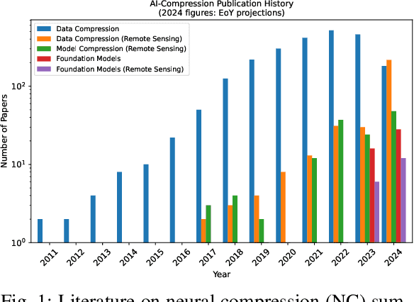
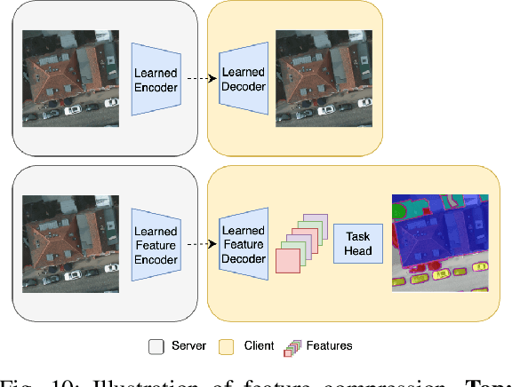
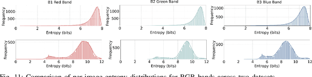
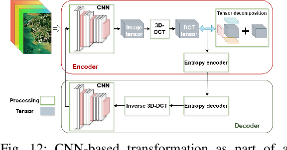
Over the past decades, there has been an explosion in the amount of available Earth Observation (EO) data. The unprecedented coverage of the Earth's surface and atmosphere by satellite imagery has resulted in large volumes of data that must be transmitted to ground stations, stored in data centers, and distributed to end users. Modern Earth System Models (ESMs) face similar challenges, operating at high spatial and temporal resolutions, producing petabytes of data per simulated day. Data compression has gained relevance over the past decade, with neural compression (NC) emerging from deep learning and information theory, making EO data and ESM outputs ideal candidates due to their abundance of unlabeled data. In this review, we outline recent developments in NC applied to geospatial data. We introduce the fundamental concepts of NC including seminal works in its traditional applications to image and video compression domains with focus on lossy compression. We discuss the unique characteristics of EO and ESM data, contrasting them with "natural images", and explain the additional challenges and opportunities they present. Moreover, we review current applications of NC across various EO modalities and explore the limited efforts in ESM compression to date. The advent of self-supervised learning (SSL) and foundation models (FM) has advanced methods to efficiently distill representations from vast unlabeled data. We connect these developments to NC for EO, highlighting the similarities between the two fields and elaborate on the potential of transferring compressed feature representations for machine--to--machine communication. Based on insights drawn from this review, we devise future directions relevant to applications in EO and ESM.
Prithvi-EO-2.0: A Versatile Multi-Temporal Foundation Model for Earth Observation Applications
Dec 03, 2024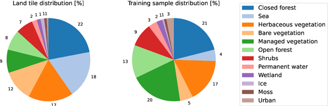
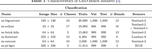
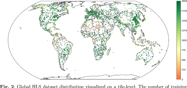
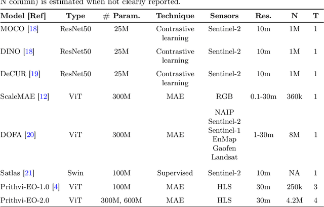
This technical report presents Prithvi-EO-2.0, a new geospatial foundation model that offers significant improvements over its predecessor, Prithvi-EO-1.0. Trained on 4.2M global time series samples from NASA's Harmonized Landsat and Sentinel-2 data archive at 30m resolution, the new 300M and 600M parameter models incorporate temporal and location embeddings for enhanced performance across various geospatial tasks. Through extensive benchmarking with GEO-Bench, the 600M version outperforms the previous Prithvi-EO model by 8\% across a range of tasks. It also outperforms six other geospatial foundation models when benchmarked on remote sensing tasks from different domains and resolutions (i.e. from 0.1m to 15m). The results demonstrate the versatility of the model in both classical earth observation and high-resolution applications. Early involvement of end-users and subject matter experts (SMEs) are among the key factors that contributed to the project's success. In particular, SME involvement allowed for constant feedback on model and dataset design, as well as successful customization for diverse SME-led applications in disaster response, land use and crop mapping, and ecosystem dynamics monitoring. Prithvi-EO-2.0 is available on Hugging Face and IBM terratorch, with additional resources on GitHub. The project exemplifies the Trusted Open Science approach embraced by all involved organizations.