Campbell D. Watson
Fourier Neural Operators for Arbitrary Resolution Climate Data Downscaling
May 23, 2023


Abstract:Climate simulations are essential in guiding our understanding of climate change and responding to its effects. However, it is computationally expensive to resolve complex climate processes at high spatial resolution. As one way to speed up climate simulations, neural networks have been used to downscale climate variables from fast-running low-resolution simulations, but high-resolution training data are often unobtainable or scarce, greatly limiting accuracy. In this work, we propose a downscaling method based on the Fourier neural operator. It trains with data of a small upsampling factor and then can zero-shot downscale its input to arbitrary unseen high resolution. Evaluated both on ERA5 climate model data and on the Navier-Stokes equation solution data, our downscaling model significantly outperforms state-of-the-art convolutional and generative adversarial downscaling models, both in standard single-resolution downscaling and in zero-shot generalization to higher upsampling factors. Furthermore, we show that our method also outperforms state-of-the-art data-driven partial differential equation solvers on Navier-Stokes equations. Overall, our work bridges the gap between simulation of a physical process and interpolation of low-resolution output, showing that it is possible to combine both approaches and significantly improve upon each other.
Aboveground carbon biomass estimate with Physics-informed deep network
Oct 25, 2022Abstract:The global carbon cycle is a key process to understand how our climate is changing. However, monitoring the dynamics is difficult because a high-resolution robust measurement of key state parameters including the aboveground carbon biomass (AGB) is required. Here, we use deep neural network to generate a wall-to-wall map of AGB within the Continental USA (CONUS) with 30-meter spatial resolution for the year 2021. We combine radar and optical hyperspectral imagery, with a physical climate parameter of SIF-based GPP. Validation results show that a masked variation of UNet has the lowest validation RMSE of 37.93 $\pm$ 1.36 Mg C/ha, as compared to 52.30 $\pm$ 0.03 Mg C/ha for random forest algorithm. Furthermore, models that learn from SIF-based GPP in addition to radar and optical imagery reduce validation RMSE by almost 10% and the standard deviation by 40%. Finally, we apply our model to measure losses in AGB from the recent 2021 Caldor wildfire in California, and validate our analysis with Sentinel-based burn index.
Addressing Deep Learning Model Uncertainty in Long-Range Climate Forecasting with Late Fusion
Dec 10, 2021


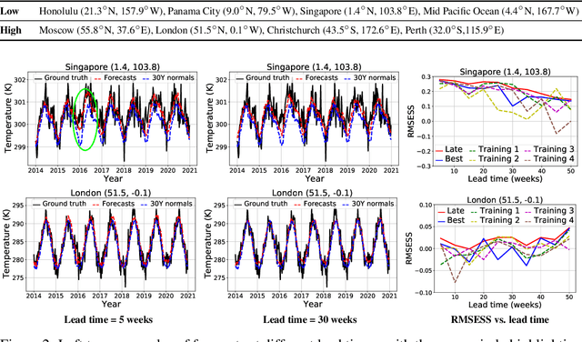
Abstract:Global warming leads to the increase in frequency and intensity of climate extremes that cause tremendous loss of lives and property. Accurate long-range climate prediction allows more time for preparation and disaster risk management for such extreme events. Although machine learning approaches have shown promising results in long-range climate forecasting, the associated model uncertainties may reduce their reliability. To address this issue, we propose a late fusion approach that systematically combines the predictions from multiple models to reduce the expected errors of the fused results. We also propose a network architecture with the novel denormalization layer to gain the benefits of data normalization without actually normalizing the data. The experimental results on long-range 2m temperature forecasting show that the framework outperforms the 30-year climate normals, and the accuracy can be improved by increasing the number of models.
A modular framework for extreme weather generation
Feb 05, 2021

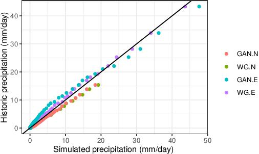
Abstract:Extreme weather events have an enormous impact on society and are expected to become more frequent and severe with climate change. In this context, resilience planning becomes crucial for risk mitigation and coping with these extreme events. Machine learning techniques can play a critical role in resilience planning through the generation of realistic extreme weather event scenarios that can be used to evaluate possible mitigation actions. This paper proposes a modular framework that relies on interchangeable components to produce extreme weather event scenarios. We discuss possible alternatives for each of the components and show initial results comparing two approaches on the task of generating precipitation scenarios.
 Add to Chrome
 Add to Firefox
 Add to Edge