Chanyeol Yoo
Decentralised Active Perception in Continuous Action Spaces for the Coordinated Escort Problem
May 03, 2023


Abstract:We consider the coordinated escort problem, where a decentralised team of supporting robots implicitly assist the mission of higher-value principal robots. The defining challenge is how to evaluate the effect of supporting robots' actions on the principal robots' mission. To capture this effect, we define two novel auxiliary reward functions for supporting robots called satisfaction improvement and satisfaction entropy, which computes the improvement in probability of mission success, or the uncertainty thereof. Given these reward functions, we coordinate the entire team of principal and supporting robots using decentralised cross entropy method (Dec-CEM), a new extension of CEM to multi-agent systems based on the product distribution approximation. In a simulated object avoidance scenario, our planning framework demonstrates up to two-fold improvement in task satisfaction against conventional decoupled information gathering.The significance of our results is to introduce a new family of algorithmic problems that will enable important new practical applications of heterogeneous multi-robot systems.
Continuous Planning for Inertial-Aided Systems
Sep 12, 2022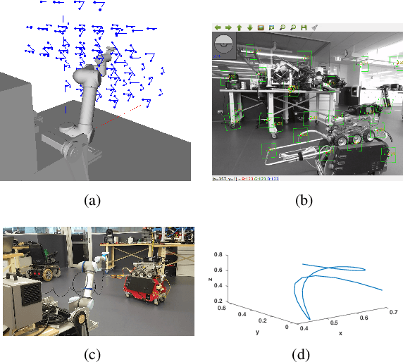

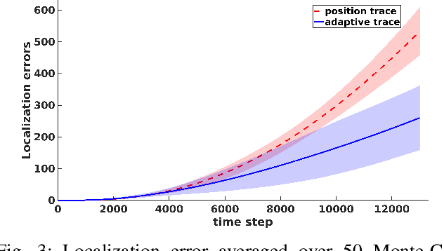
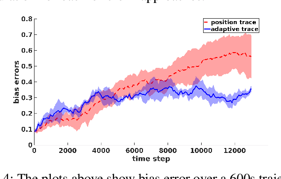
Abstract:Inertial-aided systems require continuous motion excitation among other reasons to characterize the measurement biases that will enable accurate integration required for localization frameworks. This paper proposes the use of informative path planning to find the best trajectory for minimizing the uncertainty of IMU biases and an adaptive traces method to guide the planner towards trajectories which aid convergence. The key contribution is a novel regression method based on Gaussian Process (GP) to enforce continuity and differentiability between waypoints from a variant of the RRT* planning algorithm. We employ linear operators applied to the GP kernel function to infer not only continuous position trajectories, but also velocities and accelerations. The use of linear functionals enable velocity and acceleration constraints given by the IMU measurements to be imposed on the position GP model. The results from both simulation and real world experiments show that planning for IMU bias convergence helps minimize localization errors in state estimation frameworks.
Informative Planning for Worst-Case Error Minimisation in Sparse Gaussian Process Regression
Mar 08, 2022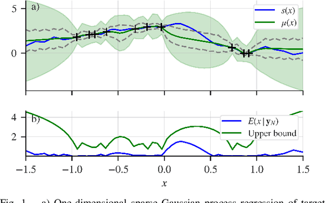
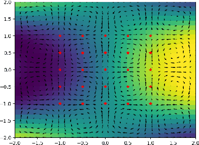
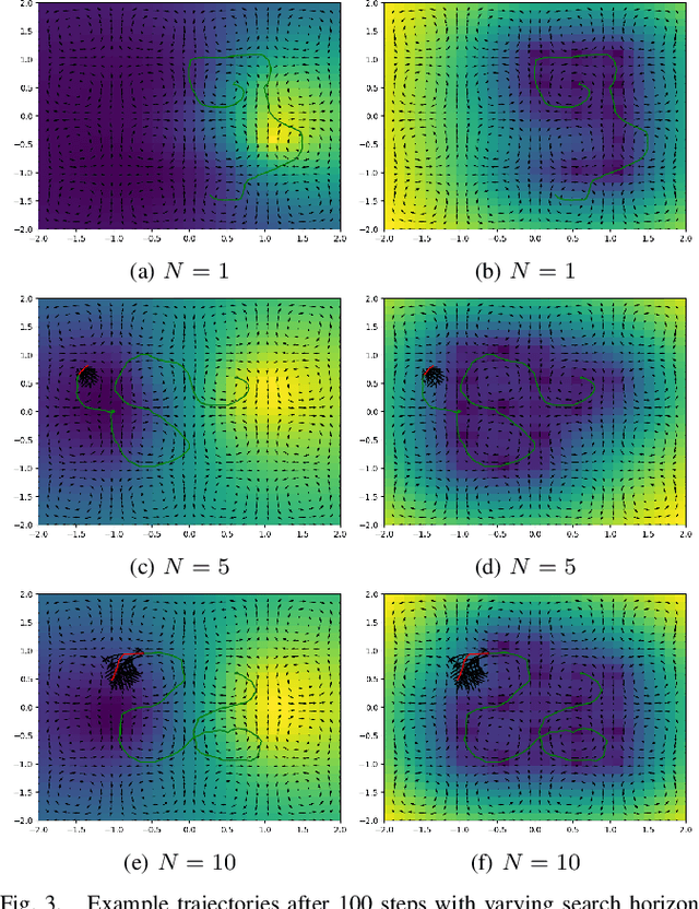
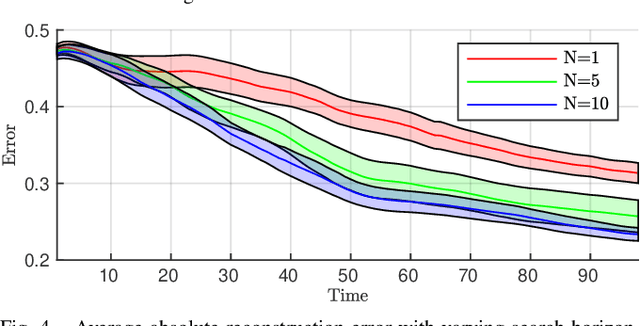
Abstract:We present a planning framework for minimising the deterministic worst-case error in sparse Gaussian process (GP) regression. We first derive a universal worst-case error bound for sparse GP regression with bounded noise using interpolation theory on reproducing kernel Hilbert spaces (RKHSs). By exploiting the conditional independence (CI) assumption central to sparse GP regression, we show that the worst-case error minimisation can be achieved by solving a posterior entropy minimisation problem. In turn, the posterior entropy minimisation problem is solved using a Gaussian belief space planning algorithm. We corroborate the proposed worst-case error bound in a simple 1D example, and test the planning framework in simulation for a 2D vehicle in a complex flow field. Our results demonstrate that the proposed posterior entropy minimisation approach is effective in minimising deterministic error, and outperforms the conventional measurement entropy maximisation formulation when the inducing points are fixed.
Field trial on Ocean Estimation for Multi-Vessel Multi-Float-based Active perception
Jun 17, 2021
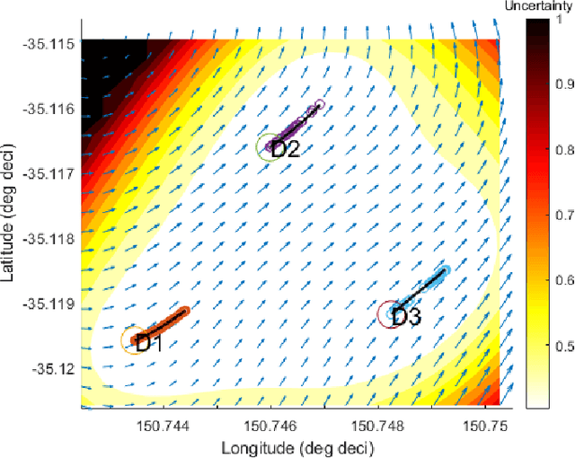


Abstract:Marine vehicles have been used for various scientific missions where information over features of interest is collected. In order to maximise efficiency in collecting information over a large search space, we should be able to deploy a large number of autonomous vehicles that make a decision based on the latest understanding of the target feature in the environment. In our previous work, we have presented a hierarchical framework for the multi-vessel multi-float (MVMF) problem where surface vessels drop and pick up underactuated floats in a time-minimal way. In this paper, we present the field trial results using the framework with a number of drifters and floats. We discovered a number of important aspects that need to be considered in the proposed framework, and present the potential approaches to address the challenges.
Decentralised Intelligence, Surveillance, and Reconnaissance in Unknown Environments with Heterogeneous Multi-Robot Systems
Jun 17, 2021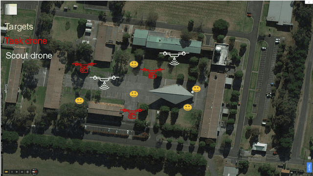
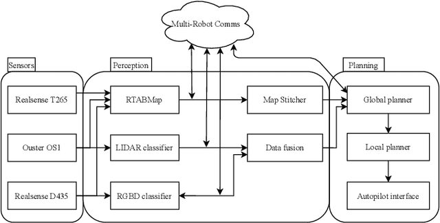
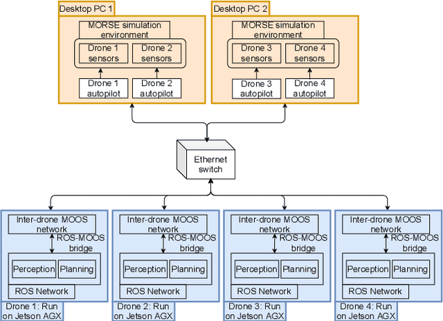
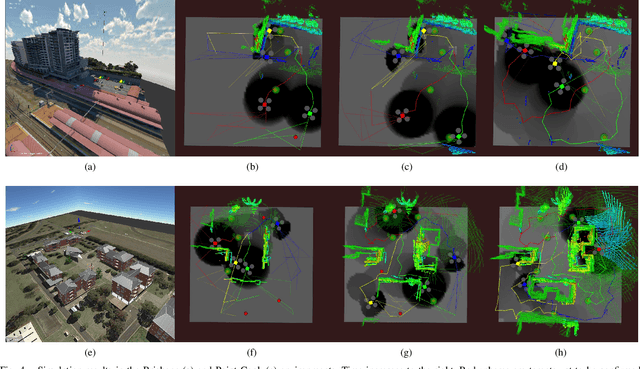
Abstract:We present the design and implementation of a decentralised, heterogeneous multi-robot system for performing intelligence, surveillance and reconnaissance (ISR) in an unknown environment. The team consists of functionally specialised robots that gather information and others that perform a mission-specific task, and is coordinated to achieve simultaneous exploration and exploitation in the unknown environment. We present a practical implementation of such a system, including decentralised inter-robot localisation, mapping, data fusion and coordination. The system is demonstrated in an efficient distributed simulation. We also describe an UAS platform for hardware experiments, and the ongoing progress.
Signal Temporal Logic Synthesis as Probabilistic Inference
May 13, 2021


Abstract:We reformulate the signal temporal logic (STL) synthesis problem as a maximum a-posteriori (MAP) inference problem. To this end, we introduce the notion of random STL~(RSTL), which extends deterministic STL with random predicates. This new probabilistic extension naturally leads to a synthesis-as-inference approach. The proposed method allows for differentiable, gradient-based synthesis while extending the class of possible uncertain semantics. We demonstrate that the proposed framework scales well with GPU-acceleration, and present realistic applications of uncertain semantics in robotics that involve target tracking and the use of occupancy grids.
An Upper Confidence Bound for Simultaneous Exploration and Exploitation in Heterogeneous Multi-Robot Systems
May 13, 2021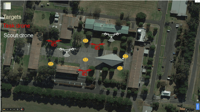
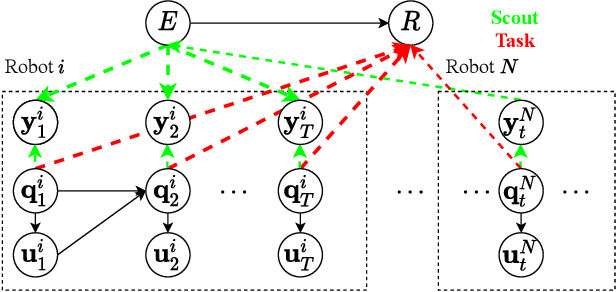
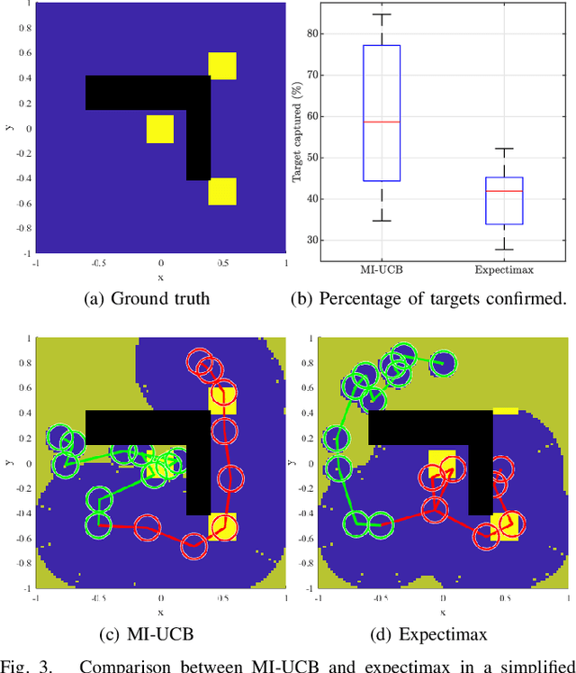
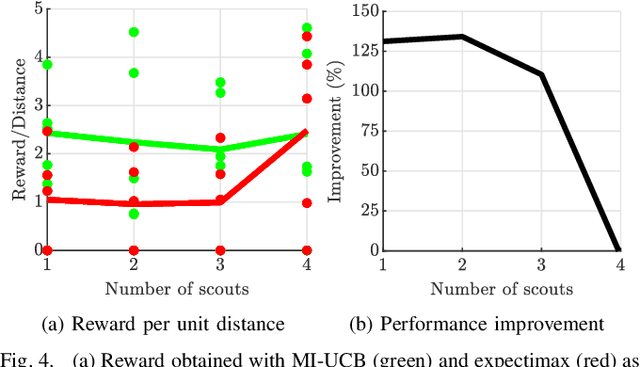
Abstract:Heterogeneous multi-robot systems are advantageous for operations in unknown environments because functionally specialised robots can gather environmental information, while others perform tasks. We define this decomposition as the scout-task robot architecture and show how it avoids the need to explicitly balance exploration and exploitation~by permitting the system to do both simultaneously. The challenge is to guide exploration in a way that improves overall performance for time-limited tasks. We derive a novel upper confidence bound for simultaneous exploration and exploitation based on mutual information and present a general solution for scout-task coordination using decentralised Monte Carlo tree search. We evaluate the performance of our algorithms in a multi-drone surveillance scenario in which scout robots are equipped with low-resolution, long-range sensors and task robots capture detailed information using short-range sensors. The results address a new class of coordination problem for heterogeneous teams that has many practical applications.
Estimation of Spatially-Correlated Ocean Currents from Ensemble Forecasts and Online Measurements
Mar 23, 2021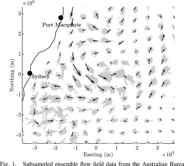
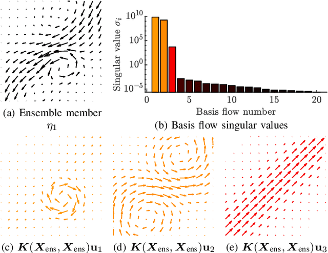


Abstract:We present a method to estimate two-dimensional, time-invariant oceanic flow fields based on data from both ensemble forecasts and online measurements. Our method produces a realistic estimate in a computationally efficient manner suitable for use in marine robotics for path planning and related applications. We use kernel methods and singular value decomposition to find a compact model of the ensemble data that is represented as a linear combination of basis flow fields and that preserves the spatial correlations present in the data. Online measurements of ocean current, taken for example by marine robots, can then be incorporated using recursive Bayesian estimation. We provide computational analysis, performance comparisons with related methods, and demonstration with real-world ensemble data to show the computational efficiency and validity of our method. Possible applications in addition to path planning include active perception for model improvement through deliberate choice of measurement locations.
Distance and Steering Heuristics for Streamline-Based Flow Field Planning
May 14, 2020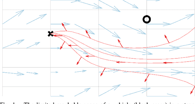
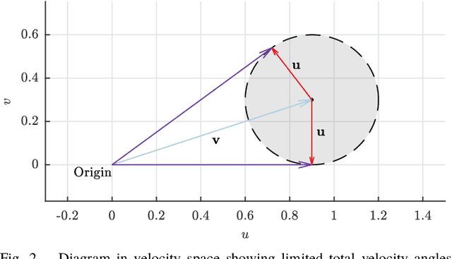
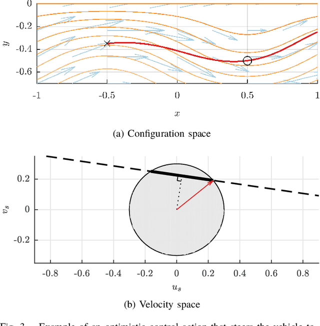

Abstract:Motion planning for vehicles under the influence of flow fields can benefit from the idea of streamline-based planning, which exploits ideas from fluid dynamics to achieve computational efficiency. Important to such planners is an efficient means of computing the travel distance and direction between two points in free space, but this is difficult to achieve in strong incompressible flows such as ocean currents. We propose two useful distance functions in analytical form that combine Euclidean distance with values of the stream function associated with a flow field, and with an estimation of the strength of the opposing flow between two points. Further, we propose steering heuristics that are useful for steering towards a sampled point. We evaluate these ideas by integrating them with RRT* and comparing the algorithm's performance with state-of-the-art methods in an artificial flow field and in actual ocean prediction data in the region of the dominant East Australian Current between Sydney and Brisbane. Results demonstrate the method's computational efficiency and ability to find high-quality paths outperforming state-of-the-art methods, and show promise for practical use with autonomous marine robots.
Minimally Invasive Social Navigation
May 08, 2020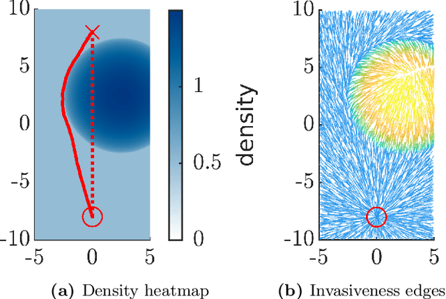

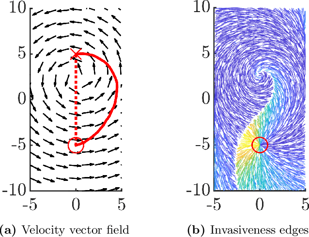
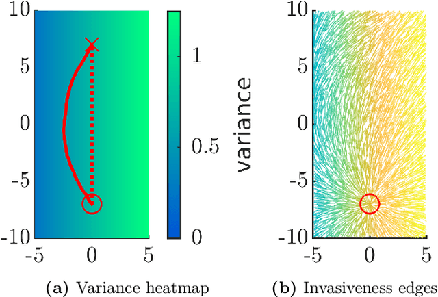
Abstract:Integrating mobile robots into human society involves the fundamental problem of navigation in crowds. This problem has been studied by considering the behaviour of humans at the level of individuals, but this representation limits the computational efficiency of motion planning algorithms. We explore the idea of representing a crowd as a flow field, and propose a formal definition of path quality based on the concept of invasiveness; a robot should attempt to navigate in a way that is minimally invasive to humans in its environment. We develop an algorithmic framework for path planning based on this definition and present experimental results that indicate its effectiveness. These results open new algorithmic questions motivated by the flow field representation of crowds and are a necessary step on the path to end-to-end implementations.
 Add to Chrome
 Add to Firefox
 Add to Edge