Yiqing Guo
Hyperspectral in situ remote sensing of water surface nitrate in the Fitzroy River estuary, Queensland, Australia, using deep learning
May 23, 2025Abstract:Nitrate ($\text{NO}_3^-$) is a form of dissolved inorganic nitrogen derived primarily from anthropogenic sources. The recent increase in river-discharged nitrate poses a major risk for coral bleaching in the Great Barrier Reef (GBR) lagoon. Although nitrate is an optically inactive (i.e., colourless) constituent, previous studies have demonstrated there is an indirect, non-causal relationship between water surface nitrate and water-leaving reflectance that is mediated through optically active water quality parameters such as total suspended solids and coloured dissolved organic matter. This work aims to advance our understanding of this relationship with an effort to measure time-series nitrate and simultaneous hyperspectral reflectance at the Fitzroy River estuary, Queensland, Australia. Time-series observations revealed periodic cycles in nitrate loads due to the tidal influence in the estuarine study site. The water surface nitrate loads were predicted from hyperspectral reflectance and water salinity measurements, with hyperspectral reflectance indicating the concentrations of optically active variables and salinity indicating the mixing of river water and seawater proportions. The accuracy assessment of model-predicted nitrate against in-situ measured nitrate values showed that the predicted nitrate values correlated well with the ground-truth data, with an $R^2$ score of 0.86, and an RMSE of 0.03 mg/L. This work demonstrates the feasibility of predicting water surface nitrate from hyperspectral reflectance and salinity measurements.
Decadal analysis of sea surface temperature patterns, climatology, and anomalies in temperate coastal waters with Landsat-8 TIRS observations
Mar 07, 2025Abstract:Sea surface temperature (SST) is a fundamental physical parameter characterising the thermal state of sea surface. The Thermal Infrared Sensor (TIRS) onboard Landsat-8, with its 100-meter spatial resolution, offers a unique opportunity to uncover fine-scale coastal SST patterns that would otherwise be overlooked by coarser-resolution thermal sensors. In this study, we first develop an operational approach for SST retrieval from the TIRS sensor, and subsequently propose a novel algorithm for establishing daily SST climatology which serves as the baseline to detect anomalous SST events. We applied the proposed methods to temperate coastal waters in South Australia for the ten-year period from 2014 to 2023. For ground validation purposes, a buoy was deployed off the coast of Port Lincoln, South Australia, to record in-situ time-series SST. The spatiotemporal patterns of SST in the study area were analysed based on the ten years of satellite-derived SST imagery. The daily baseline climatology of SST with 100 m resolution was constructed, which allowed for the detection and analysis of anomalous SST events during the study period of 2014-2023. Our results suggest the following: (1) the satellite-derived SST data, generated with the proposed algorithm, aligned well with the in-situ measured SST values; (2) the semi-enclosed, shallow regions of Upper Spencer Gulf and Upper St Vincent Gulf showed higher temperatures during summer and cooler temperatures during winter than waters closer to the open ocean, resulting in a higher seasonal variation in SST; (3) the near-shore shallow areas in Spencer Gulf and St Vincent Gulf, and regions surrounding Kangaroo Island, were identified to have a higher probability of SST anomalies compared to the rest of the study area; and (4) anomalous SST events were more likely to happen during the warm months than the cool months.
Sharper Error Bounds in Late Fusion Multi-view Clustering Using Eigenvalue Proportion
Dec 24, 2024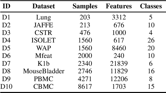

Abstract:Multi-view clustering (MVC) aims to integrate complementary information from multiple views to enhance clustering performance. Late Fusion Multi-View Clustering (LFMVC) has shown promise by synthesizing diverse clustering results into a unified consensus. However, current LFMVC methods struggle with noisy and redundant partitions and often fail to capture high-order correlations across views. To address these limitations, we present a novel theoretical framework for analyzing the generalization error bounds of multiple kernel $k$-means, leveraging local Rademacher complexity and principal eigenvalue proportions. Our analysis establishes a convergence rate of $\mathcal{O}(1/n)$, significantly improving upon the existing rate in the order of $\mathcal{O}(\sqrt{k/n})$. Building on this insight, we propose a low-pass graph filtering strategy within a multiple linear $k$-means framework to mitigate noise and redundancy, further refining the principal eigenvalue proportion and enhancing clustering accuracy. Experimental results on benchmark datasets confirm that our approach outperforms state-of-the-art methods in clustering performance and robustness. The related codes is available at https://github.com/csliangdu/GMLKM .
Spatioformer: A Geo-encoded Transformer for Large-Scale Plant Species Richness Prediction
Oct 25, 2024Abstract:Earth observation data have shown promise in predicting species richness of vascular plants ($\alpha$-diversity), but extending this approach to large spatial scales is challenging because geographically distant regions may exhibit different compositions of plant species ($\beta$-diversity), resulting in a location-dependent relationship between richness and spectral measurements. In order to handle such geolocation dependency, we propose Spatioformer, where a novel geolocation encoder is coupled with the transformer model to encode geolocation context into remote sensing imagery. The Spatioformer model compares favourably to state-of-the-art models in richness predictions on a large-scale ground-truth richness dataset (HAVPlot) that consists of 68,170 in-situ richness samples covering diverse landscapes across Australia. The results demonstrate that geolocational information is advantageous in predicting species richness from satellite observations over large spatial scales. With Spatioformer, plant species richness maps over Australia are compiled from Landsat archive for the years from 2015 to 2023. The richness maps produced in this study reveal the spatiotemporal dynamics of plant species richness in Australia, providing supporting evidence to inform effective planning and policy development for plant diversity conservation. Regions of high richness prediction uncertainties are identified, highlighting the need for future in-situ surveys to be conducted in these areas to enhance the prediction accuracy.
Harmonic enhancement using learnable comb filter for light-weight full-band speech enhancement model
Jun 01, 2023


Abstract:With fewer feature dimensions, filter banks are often used in light-weight full-band speech enhancement models. In order to further enhance the coarse speech in the sub-band domain, it is necessary to apply a post-filtering for harmonic retrieval. The signal processing-based comb filters used in RNNoise and PercepNet have limited performance and may cause speech quality degradation due to inaccurate fundamental frequency estimation. To tackle this problem, we propose a learnable comb filter to enhance harmonics. Based on the sub-band model, we design a DNN-based fundamental frequency estimator to estimate the discrete fundamental frequencies and a comb filter for harmonic enhancement, which are trained via an end-to-end pattern. The experiments show the advantages of our proposed method over PecepNet and DeepFilterNet.
Personalized speech enhancement combining band-split RNN and speaker attentive module
Feb 20, 2023
Abstract:Target speaker information can be utilized in speech enhancement (SE) models to more effectively extract the desired speech. Previous works introduce the speaker embedding into speech enhancement models by means of concatenation or affine transformation. In this paper, we propose a speaker attentive module to calculate the attention scores between the speaker embedding and the intermediate features, which are used to rescale the features. By merging this module in the state-of-the-art SE model, we construct the personalized SE model for ICASSP Signal Processing Grand Challenge: DNS Challenge 5 (2023). Our system achieves a final score of 0.529 on the blind test set of track1 and 0.549 on track2.
Plant species richness prediction from DESIS hyperspectral data: A comparison study on feature extraction procedures and regression models
Jan 05, 2023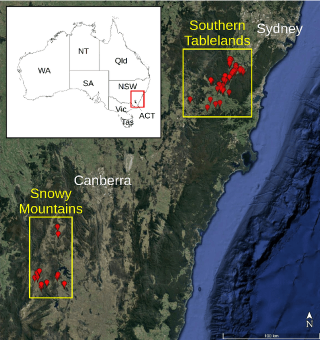
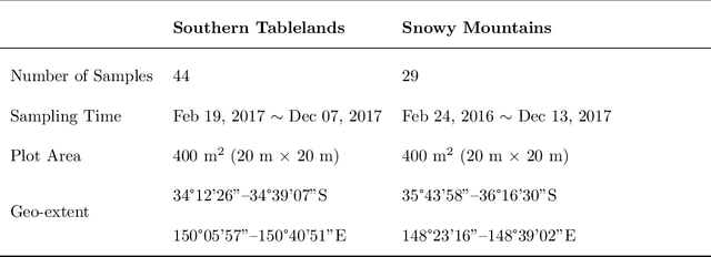
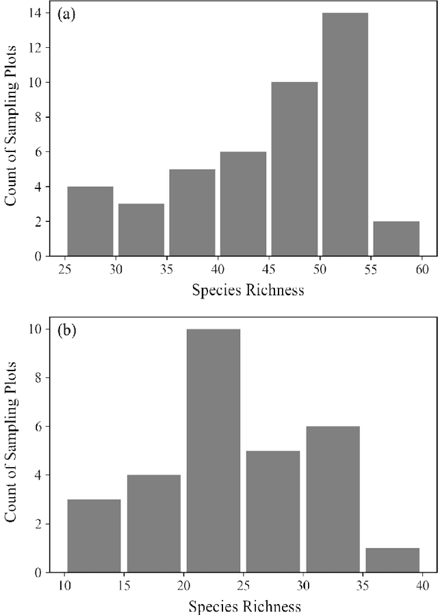
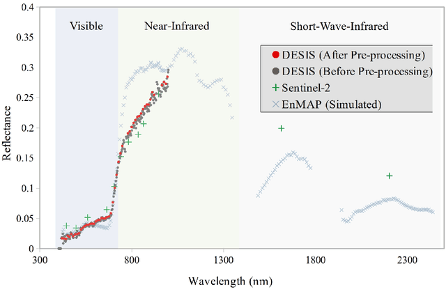
Abstract:The diversity of terrestrial vascular plants plays a key role in maintaining the stability and productivity of ecosystems. Monitoring species compositional diversity across large spatial scales is challenging and time consuming. The advanced spectral and spatial specification of the recently launched DESIS (the DLR Earth Sensing Imaging Spectrometer) instrument provides a unique opportunity to test the potential for monitoring plant species diversity with spaceborne hyperspectral data. This study provides a quantitative assessment on the ability of DESIS hyperspectral data for predicting plant species richness in two different habitat types in southeast Australia. Spectral features were first extracted from the DESIS spectra, then regressed against on-ground estimates of plant species richness, with a two-fold cross validation scheme to assess the predictive performance. We tested and compared the effectiveness of Principal Component Analysis (PCA), Canonical Correlation Analysis (CCA), and Partial Least Squares analysis (PLS) for feature extraction, and Kernel Ridge Regression (KRR), Gaussian Process Regression (GPR), Random Forest Regression (RFR) for species richness prediction. The best prediction results were r=0.76 and RMSE=5.89 for the Southern Tablelands region, and r=0.68 and RMSE=5.95 for the Snowy Mountains region. Relative importance analysis for the DESIS spectral bands showed that the red-edge, red, and blue spectral regions were more important for predicting plant species richness than the green bands and the near-infrared bands beyond red-edge. We also found that the DESIS hyperspectral data performed better than Sentinel-2 multispectral data in the prediction of plant species richness. Our results provide a quantitative reference for future studies exploring the potential of spaceborne hyperspectral data for plant biodiversity mapping.
Quantitative Assessment of DESIS Hyperspectral Data for Plant Biodiversity Estimation in Australia
Jul 06, 2022


Abstract:Diversity of terrestrial plants plays a key role in maintaining a stable, healthy, and productive ecosystem. Though remote sensing has been seen as a promising and cost-effective proxy for estimating plant diversity, there is a lack of quantitative studies on how confidently plant diversity can be inferred from spaceborne hyperspectral data. In this study, we assessed the ability of hyperspectral data captured by the DLR Earth Sensing Imaging Spectrometer (DESIS) for estimating plant species richness in the Southern Tablelands and Snowy Mountains regions in southeast Australia. Spectral features were firstly extracted from DESIS spectra with principal component analysis, canonical correlation analysis, and partial least squares analysis. Then regression was conducted between the extracted features and plant species richness with ordinary least squares regression, kernel ridge regression, and Gaussian process regression. Results were assessed with the coefficient of correlation ($r$) and Root-Mean-Square Error (RMSE), based on a two-fold cross validation scheme. With the best performing model, $r$ is 0.71 and RMSE is 5.99 for the Southern Tablelands region, while $r$ is 0.62 and RMSE is 6.20 for the Snowy Mountains region. The assessment results reported in this study provide supports for future studies on understanding the relationship between spaceborne hyperspectral measurements and terrestrial plant biodiversity.
Effective Sequential Classifier Training for SVM-based Multitemporal Remote Sensing Image Classification
Jan 17, 2018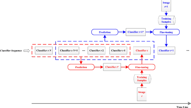
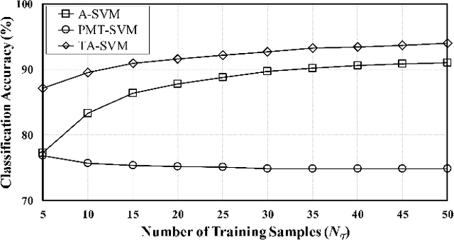
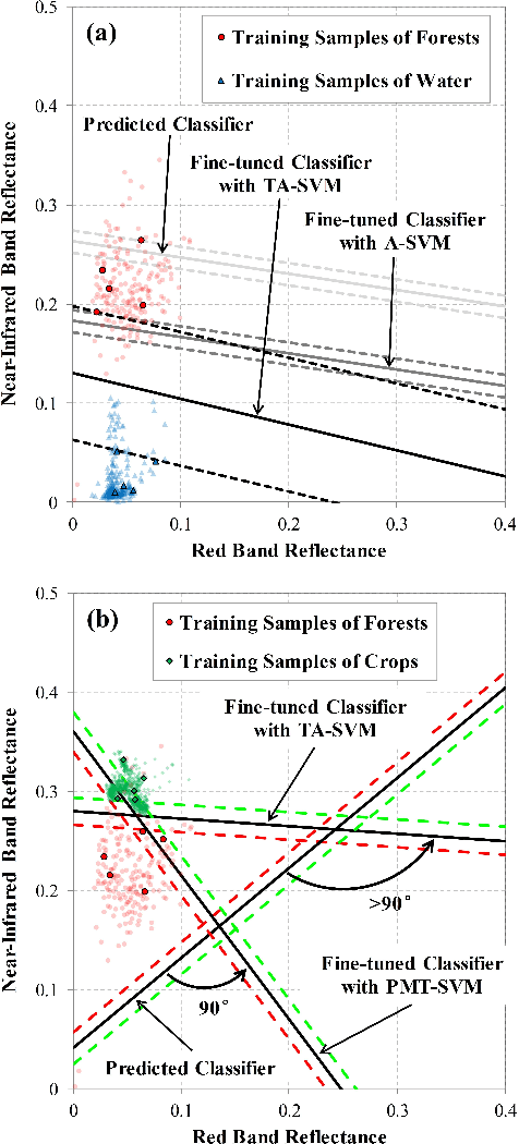
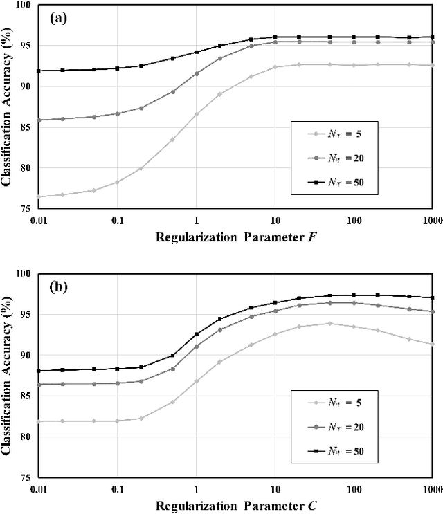
Abstract:The explosive availability of remote sensing images has challenged supervised classification algorithms such as Support Vector Machines (SVM), as training samples tend to be highly limited due to the expensive and laborious task of ground truthing. The temporal correlation and spectral similarity between multitemporal images have opened up an opportunity to alleviate this problem. In this study, a SVM-based Sequential Classifier Training (SCT-SVM) approach is proposed for multitemporal remote sensing image classification. The approach leverages the classifiers of previous images to reduce the required number of training samples for the classifier training of an incoming image. For each incoming image, a rough classifier is firstly predicted based on the temporal trend of a set of previous classifiers. The predicted classifier is then fine-tuned into a more accurate position with current training samples. This approach can be applied progressively to sequential image data, with only a small number of training samples being required from each image. Experiments were conducted with Sentinel-2A multitemporal data over an agricultural area in Australia. Results showed that the proposed SCT-SVM achieved better classification accuracies compared with two state-of-the-art model transfer algorithms. When training data are insufficient, the overall classification accuracy of the incoming image was improved from 76.18% to 94.02% with the proposed SCT-SVM, compared with those obtained without the assistance from previous images. These results demonstrate that the leverage of a priori information from previous images can provide advantageous assistance for later images in multitemporal image classification.
 Add to Chrome
 Add to Firefox
 Add to Edge