Wenyuan Li
EmbodiedBrain: Expanding Performance Boundaries of Task Planning for Embodied Intelligence
Oct 23, 2025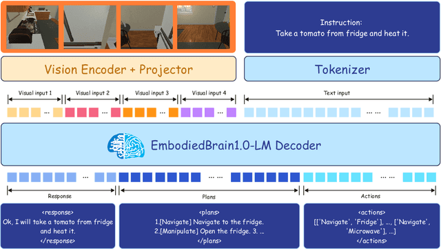

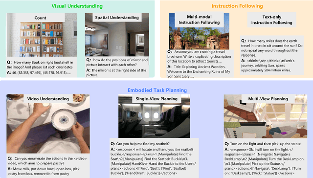
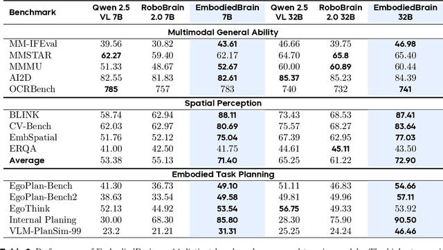
Abstract:The realization of Artificial General Intelligence (AGI) necessitates Embodied AI agents capable of robust spatial perception, effective task planning, and adaptive execution in physical environments. However, current large language models (LLMs) and multimodal LLMs (MLLMs) for embodied tasks suffer from key limitations, including a significant gap between model design and agent requirements, an unavoidable trade-off between real-time latency and performance, and the use of unauthentic, offline evaluation metrics. To address these challenges, we propose EmbodiedBrain, a novel vision-language foundation model available in both 7B and 32B parameter sizes. Our framework features an agent-aligned data structure and employs a powerful training methodology that integrates large-scale Supervised Fine-Tuning (SFT) with Step-Augumented Group Relative Policy Optimization (Step-GRPO), which boosts long-horizon task success by integrating preceding steps as Guided Precursors. Furthermore, we incorporate a comprehensive reward system, including a Generative Reward Model (GRM) accelerated at the infrastructure level, to improve training efficiency. For enable thorough validation, we establish a three-part evaluation system encompassing General, Planning, and End-to-End Simulation Benchmarks, highlighted by the proposal and open-sourcing of a novel, challenging simulation environment. Experimental results demonstrate that EmbodiedBrain achieves superior performance across all metrics, establishing a new state-of-the-art for embodied foundation models. Towards paving the way for the next generation of generalist embodied agents, we open-source all of our data, model weight, and evaluating methods, which are available at https://zterobot.github.io/EmbodiedBrain.github.io.
Periodic evaluation of defined-contribution pension fund: A dynamic risk measure approach
Aug 07, 2025Abstract:This paper introduces an innovative framework for the periodic evaluation of defined-contribution pension funds. The performance of the pension fund is evaluated not only at retirement, but also within the interim periods. In contrast to the traditional literature, we set the dynamic risk measure as the criterion and manage the tail risk of the pension fund dynamically. To effectively interact with the stochastic environment, a model-free reinforcement learning algorithm is proposed to search for optimal investment and insurance strategies. Using U.S. data, we calibrate pension members' mortality rates and enhance mortality projections through a Lee-Carter model. Our numerical results indicate that periodic evaluations lead to more risk-averse strategies, while mortality improvements encourage more risk-seeking behaviors.
Fine-grained Hierarchical Crop Type Classification from Integrated Hyperspectral EnMAP Data and Multispectral Sentinel-2 Time Series: A Large-scale Dataset and Dual-stream Transformer Method
Jun 09, 2025Abstract:Fine-grained crop type classification serves as the fundamental basis for large-scale crop mapping and plays a vital role in ensuring food security. It requires simultaneous capture of both phenological dynamics (obtained from multi-temporal satellite data like Sentinel-2) and subtle spectral variations (demanding nanometer-scale spectral resolution from hyperspectral imagery). Research combining these two modalities remains scarce currently due to challenges in hyperspectral data acquisition and crop types annotation costs. To address these issues, we construct a hierarchical hyperspectral crop dataset (H2Crop) by integrating 30m-resolution EnMAP hyperspectral data with Sentinel-2 time series. With over one million annotated field parcels organized in a four-tier crop taxonomy, H2Crop establishes a vital benchmark for fine-grained agricultural crop classification and hyperspectral image processing. We propose a dual-stream Transformer architecture that synergistically processes these modalities. It coordinates two specialized pathways: a spectral-spatial Transformer extracts fine-grained signatures from hyperspectral EnMAP data, while a temporal Swin Transformer extracts crop growth patterns from Sentinel-2 time series. The designed hierarchical classification head with hierarchical fusion then simultaneously delivers multi-level crop type classification across all taxonomic tiers. Experiments demonstrate that adding hyperspectral EnMAP data to Sentinel-2 time series yields a 4.2% average F1-scores improvement (peaking at 6.3%). Extensive comparisons also confirm our method's higher accuracy over existing deep learning approaches for crop type classification and the consistent benefits of hyperspectral data across varying temporal windows and crop change scenarios. Codes and dataset are available at https://github.com/flyakon/H2Crop.
A Novel Large-scale Crop Dataset and Dual-stream Transformer Method for Fine-grained Hierarchical Crop Classification from Integrated Hyperspectral EnMAP Data and Multispectral Sentinel-2 Time Series
Jun 06, 2025Abstract:Fine-grained crop classification is crucial for precision agriculture and food security monitoring. It requires simultaneous capture of both phenological dynamics (obtained from multi-temporal satellite data like Sentinel-2) and subtle spectral variations (demanding nanometer-scale spectral resolution from hyperspectral imagery). Research combining these two modalities remains scarce currently due to challenges in hyperspectral data acquisition and crop types annotation costs. To address these issues, we construct a hierarchical hyperspectral crop dataset (H2Crop) by integrating 30m-resolution EnMAP hyperspectral data with Sentinel-2 time series. With over one million annotated field parcels organized in a four-tier crop taxonomy, H2Crop establishes a vital benchmark for fine-grained agricultural crop classification and hyperspectral image processing. We propose a dual-stream Transformer architecture that synergistically processes these modalities. It coordinates two specialized pathways: a spectral-spatial Transformer extracts fine-grained signatures from hyperspectral EnMAP data, while a temporal Swin Transformer extracts crop growth patterns from Sentinel-2 time series. The designed hierarchy classification heads with hierarchical fusion then simultaneously delivers multi-level classification across all taxonomic tiers. Experiments demonstrate that adding hyperspectral EnMAP data to Sentinel-2 time series yields a 4.2% average F1-scores improvement (peaking at 6.3%). Extensive comparisons also confirming our method's higher accuracy over existing deep learning approaches for crop type classification and the consistent benefits of hyperspectral data across varying temporal windows and crop change scenarios. Codes and dataset will be available at https://github.com/flyakon/H2Crop and www.glass.hku.hk Keywords: Crop type classification, precision agriculture, remote sensing, deep learning, hyperspectral data, Sentinel-2 time series, fine-grained crops
Hyperbolic Dataset Distillation
May 30, 2025Abstract:To address the computational and storage challenges posed by large-scale datasets in deep learning, dataset distillation has been proposed to synthesize a compact dataset that replaces the original while maintaining comparable model performance. Unlike optimization-based approaches that require costly bi-level optimization, distribution matching (DM) methods improve efficiency by aligning the distributions of synthetic and original data, thereby eliminating nested optimization. DM achieves high computational efficiency and has emerged as a promising solution. However, existing DM methods, constrained to Euclidean space, treat data as independent and identically distributed points, overlooking complex geometric and hierarchical relationships. To overcome this limitation, we propose a novel hyperbolic dataset distillation method, termed HDD. Hyperbolic space, characterized by negative curvature and exponential volume growth with distance, naturally models hierarchical and tree-like structures. HDD embeds features extracted by a shallow network into the Lorentz hyperbolic space, where the discrepancy between synthetic and original data is measured by the hyperbolic (geodesic) distance between their centroids. By optimizing this distance, the hierarchical structure is explicitly integrated into the distillation process, guiding synthetic samples to gravitate towards the root-centric regions of the original data distribution while preserving their underlying geometric characteristics. Furthermore, we find that pruning in hyperbolic space requires only 20% of the distilled core set to retain model performance, while significantly improving training stability. Notably, HDD is seamlessly compatible with most existing DM methods, and extensive experiments on different datasets validate its effectiveness.
AgriFM: A Multi-source Temporal Remote Sensing Foundation Model for Crop Mapping
May 28, 2025Abstract:Accurate crop mapping fundamentally relies on modeling multi-scale spatiotemporal patterns, where spatial scales range from individual field textures to landscape-level context, and temporal scales capture both short-term phenological transitions and full growing-season dynamics. Transformer-based remote sensing foundation models (RSFMs) offer promising potential for crop mapping due to their innate ability for unified spatiotemporal processing. However, current RSFMs remain suboptimal for crop mapping: they either employ fixed spatiotemporal windows that ignore the multi-scale nature of crop systems or completely disregard temporal information by focusing solely on spatial patterns. To bridge these gaps, we present AgriFM, a multi-source remote sensing foundation model specifically designed for agricultural crop mapping. Our approach begins by establishing the necessity of simultaneous hierarchical spatiotemporal feature extraction, leading to the development of a modified Video Swin Transformer architecture where temporal down-sampling is synchronized with spatial scaling operations. This modified backbone enables efficient unified processing of long time-series satellite inputs. AgriFM leverages temporally rich data streams from three satellite sources including MODIS, Landsat-8/9 and Sentinel-2, and is pre-trained on a global representative dataset comprising over 25 million image samples supervised by land cover products. The resulting framework incorporates a versatile decoder architecture that dynamically fuses these learned spatiotemporal representations, supporting diverse downstream tasks. Comprehensive evaluations demonstrate AgriFM's superior performance over conventional deep learning approaches and state-of-the-art general-purpose RSFMs across all downstream tasks. Codes will be available at https://github.com/flyakon/AgriFM.
DynamicVis: An Efficient and General Visual Foundation Model for Remote Sensing Image Understanding
Mar 20, 2025Abstract:The advancement of remote sensing technology has improved the spatial resolution of satellite imagery, facilitating more detailed visual representations for diverse interpretations. However, existing methods exhibit limited generalization capabilities across varied applications. While some contemporary foundation models demonstrate potential, they are hindered by insufficient cross-task adaptability and primarily process low-resolution imagery of restricted sizes, thus failing to fully exploit high-resolution data or leverage comprehensive large-scene semantics. Crucially, remote sensing imagery differs fundamentally from natural images, as key foreground targets (eg., maritime objects, artificial structures) often occupy minimal spatial proportions (~1%) and exhibit sparse distributions. Efficiently modeling cross-task generalizable knowledge from lengthy 2D tokens (~100,000) poses a significant challenge yet remains critical for remote sensing image understanding. Motivated by the selective attention mechanisms inherent to the human visual system, we propose DynamicVis, a dynamic visual perception foundation model for remote sensing imagery. The framework integrates a novel dynamic region perception backbone based on the selective state space model, which strategically balances localized detail extraction with global contextual integration, enabling computationally efficient encoding of large-scale data while maintaining architectural scalability. To enhance cross-task knowledge transferring, we introduce a multi-instance learning paradigm utilizing meta-embedding representations, trained on million-scale region-level annotations. Evaluations across nine downstream tasks demonstrate the model's versatility. DynamicVis achieves multi-level feature modeling with exceptional efficiency, processing (2048x2048) pixels with 97 ms latency (6% of ViT's) and 833 MB GPU memory (3% of ViT's).
Kolmogorov Arnold Neural Interpolator for Downscaling and Correcting Meteorological Fields from In-Situ Observations
Jan 24, 2025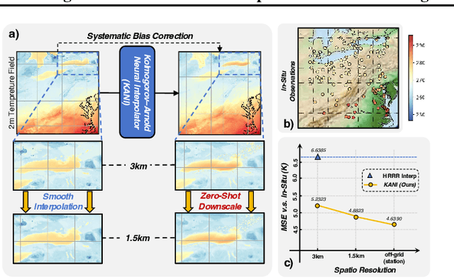

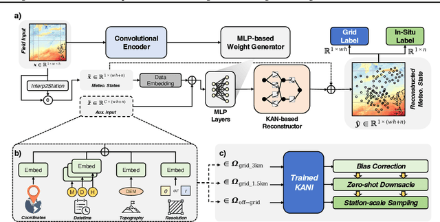
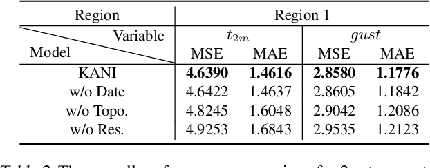
Abstract:Obtaining accurate weather forecasts at station locations is a critical challenge due to systematic biases arising from the mismatch between multi-scale, continuous atmospheric characteristic and their discrete, gridded representations. Previous works have primarily focused on modeling gridded meteorological data, inherently neglecting the off-grid, continuous nature of atmospheric states and leaving such biases unresolved. To address this, we propose the Kolmogorov Arnold Neural Interpolator (KANI), a novel framework that redefines meteorological field representation as continuous neural functions derived from discretized grids. Grounded in the Kolmogorov Arnold theorem, KANI captures the inherent continuity of atmospheric states and leverages sparse in-situ observations to correct these biases systematically. Furthermore, KANI introduces an innovative zero-shot downscaling capability, guided by high-resolution topographic textures without requiring high-resolution meteorological fields for supervision. Experimental results across three sub-regions of the continental United States indicate that KANI achieves an accuracy improvement of 40.28% for temperature and 67.41% for wind speed, highlighting its significant improvement over traditional interpolation methods. This enables continuous neural representation of meteorological variables through neural networks, transcending the limitations of conventional grid-based representations.
Cerberus: Efficient Inference with Adaptive Parallel Decoding and Sequential Knowledge Enhancement
Oct 17, 2024


Abstract:Large language models (LLMs) often face a bottleneck in inference speed due to their reliance on auto-regressive decoding. Recently, parallel decoding has shown significant promise in enhancing inference efficiency. However, we have identified two key issues with existing parallel decoding frameworks: (1) decoding heads fail to balance prediction accuracy and the parallelism of execution, and (2) parallel decoding is not a universal solution, as it can bring unnecessary overheads at some challenging decoding steps. To address these issues, we propose Cerberus, an adaptive parallel decoding framework introduces the gating mechanism to enable the LLMs to adaptively choose appropriate decoding approaches at each decoding step, along with introducing a new paradigm of decoding heads that introduce the sequential knowledge while maintaining execution parallelism. The experiment results demonstrate that the Cerberus can achieve up to 2.12x speed up compared to auto-regressive decoding, and outperforms one of the leading parallel decoding frameworks, Medusa, with a 10% - 30% increase in acceleration and superior generation quality.
MambaDS: Near-Surface Meteorological Field Downscaling with Topography Constrained Selective State Space Modeling
Aug 20, 2024


Abstract:In an era of frequent extreme weather and global warming, obtaining precise, fine-grained near-surface weather forecasts is increasingly essential for human activities. Downscaling (DS), a crucial task in meteorological forecasting, enables the reconstruction of high-resolution meteorological states for target regions from global-scale forecast results. Previous downscaling methods, inspired by CNN and Transformer-based super-resolution models, lacked tailored designs for meteorology and encountered structural limitations. Notably, they failed to efficiently integrate topography, a crucial prior in the downscaling process. In this paper, we address these limitations by pioneering the selective state space model into the meteorological field downscaling and propose a novel model called MambaDS. This model enhances the utilization of multivariable correlations and topography information, unique challenges in the downscaling process while retaining the advantages of Mamba in long-range dependency modeling and linear computational complexity. Through extensive experiments in both China mainland and the continental United States (CONUS), we validated that our proposed MambaDS achieves state-of-the-art results in three different types of meteorological field downscaling settings. We will release the code subsequently.
 Add to Chrome
 Add to Firefox
 Add to Edge