Karthik Dantu
Learning When to Jump for Off-road Navigation
Jan 31, 2026Abstract:Low speed does not always guarantee safety in off-road driving. For instance, crossing a ditch may be risky at a low speed due to the risk of getting stuck, yet safe at a higher speed with a controlled, accelerated jump. Achieving such behavior requires path planning that explicitly models complex motion dynamics, whereas existing methods often neglect this aspect and plan solely based on positions or a fixed velocity. To address this gap, we introduce Motion-aware Traversability (MAT) representation to explicitly model terrain cost conditioned on actual robot motion. Instead of assigning a single scalar score for traversability, MAT models each terrain region as a Gaussian function of velocity. During online planning, we decompose the terrain cost computation into two stages: (1) predict terrain-dependent Gaussian parameters from perception in a single forward pass, (2) efficiently update terrain costs for new velocities inferred from current dynamics by evaluating these functions without repeated inference. We develop a system that integrates MAT to enable agile off-road navigation and evaluate it in both simulated and real-world environments with various obstacles. Results show that MAT achieves real-time efficiency and enhances the performance of off-road navigation, reducing path detours by 75% while maintaining safety across challenging terrains.
CLEAR: A Semantic-Geometric Terrain Abstraction for Large-Scale Unstructured Environments
Jan 19, 2026Abstract:Long-horizon navigation in unstructured environments demands terrain abstractions that scale to tens of km$^2$ while preserving semantic and geometric structure, a combination existing methods fail to achieve. Grids scale poorly; quadtrees misalign with terrain boundaries; neither encodes landcover semantics essential for traversability-aware planning. This yields infeasible or unreliable paths for autonomous ground vehicles operating over 10+ km$^2$ under real-time constraints. CLEAR (Connected Landcover Elevation Abstract Representation) couples boundary-aware spatial decomposition with recursive plane fitting to produce convex, semantically aligned regions encoded as a terrain-aware graph. Evaluated on maps spanning 9-100~km$^2$ using a physics-based simulator, CLEAR achieves up to 10x faster planning than raw grids with only 6.7% cost overhead and delivers 6-9% shorter, more reliable paths than other abstraction baselines. These results highlight CLEAR's scalability and utility for long-range navigation in applications such as disaster response, defense, and planetary exploration.
Graphite: A GPU-Accelerated Mixed-Precision Graph Optimization Framework
Sep 30, 2025Abstract:We present Graphite, a GPU-accelerated nonlinear graph optimization framework. It provides a CUDA C++ interface to enable the sharing of code between a realtime application, such as a SLAM system, and its optimization tasks. The framework supports techniques to reduce memory usage, including in-place optimization, support for multiple floating point types and mixed-precision modes, and dynamically computed Jacobians. We evaluate Graphite on well-known bundle adjustment problems and find that it achieves similar performance to MegBA, a solver specialized for bundle adjustment, while maintaining generality and using less memory. We also apply Graphite to global visual-inertial bundle adjustment on maps generated from stereo-inertial SLAM datasets, and observe speed ups of up to 59x compared to a CPU baseline. Our results indicate that our solver enables faster large-scale optimization on both desktop and resource-constrained devices.
Active Illumination Control in Low-Light Environments using NightHawk
Jun 05, 2025Abstract:Subterranean environments such as culverts present significant challenges to robot vision due to dim lighting and lack of distinctive features. Although onboard illumination can help, it introduces issues such as specular reflections, overexposure, and increased power consumption. We propose NightHawk, a framework that combines active illumination with exposure control to optimize image quality in these settings. NightHawk formulates an online Bayesian optimization problem to determine the best light intensity and exposure-time for a given scene. We propose a novel feature detector-based metric to quantify image utility and use it as the cost function for the optimizer. We built NightHawk as an event-triggered recursive optimization pipeline and deployed it on a legged robot navigating a culvert beneath the Erie Canal. Results from field experiments demonstrate improvements in feature detection and matching by 47-197% enabling more reliable visual estimation in challenging lighting conditions.
Detailed Evaluation of Modern Machine Learning Approaches for Optic Plastics Sorting
May 22, 2025Abstract:According to the EPA, only 25% of waste is recycled, and just 60% of U.S. municipalities offer curbside recycling. Plastics fare worse, with a recycling rate of only 8%; an additional 16% is incinerated, while the remaining 76% ends up in landfills. The low plastic recycling rate stems from contamination, poor economic incentives, and technical difficulties, making efficient recycling a challenge. To improve recovery, automated sorting plays a critical role. Companies like AMP Robotics and Greyparrot utilize optical systems for sorting, while Materials Recovery Facilities (MRFs) employ Near-Infrared (NIR) sensors to detect plastic types. Modern optical sorting uses advances in computer vision such as object recognition and instance segmentation, powered by machine learning. Two-stage detectors like Mask R-CNN use region proposals and classification with deep backbones like ResNet. Single-stage detectors like YOLO handle detection in one pass, trading some accuracy for speed. While such methods excel under ideal conditions with a large volume of labeled training data, challenges arise in realistic scenarios, emphasizing the need to further examine the efficacy of optic detection for automated sorting. In this study, we compiled novel datasets totaling 20,000+ images from varied sources. Using both public and custom machine learning pipelines, we assessed the capabilities and limitations of optical recognition for sorting. Grad-CAM, saliency maps, and confusion matrices were employed to interpret model behavior. We perform this analysis on our custom trained models from the compiled datasets. To conclude, our findings are that optic recognition methods have limited success in accurate sorting of real-world plastics at MRFs, primarily because they rely on physical properties such as color and shape.
You Only Crash Once v2: Perceptually Consistent Strong Features for One-Stage Domain Adaptive Detection of Space Terrain
Jan 23, 2025


Abstract:The in-situ detection of planetary, lunar, and small-body surface terrain is crucial for autonomous spacecraft applications, where learning-based computer vision methods are increasingly employed to enable intelligence without prior information or human intervention. However, many of these methods remain computationally expensive for spacecraft processors and prevent real-time operation. Training of such algorithms is additionally complex due to the scarcity of labeled data and reliance on supervised learning approaches. Unsupervised Domain Adaptation (UDA) offers a promising solution by facilitating model training with disparate data sources such as simulations or synthetic scenes, although UDA is difficult to apply to celestial environments where challenging feature spaces are paramount. To alleviate such issues, You Only Crash Once (YOCOv1) has studied the integration of Visual Similarity-based Alignment (VSA) into lightweight one-stage object detection architectures to improve space terrain UDA. Although proven effective, the approach faces notable limitations, including performance degradations in multi-class and high-altitude scenarios. Building upon the foundation of YOCOv1, we propose novel additions to the VSA scheme that enhance terrain detection capabilities under UDA, and our approach is evaluated across both simulated and real-world data. Our second YOCO rendition, YOCOv2, is capable of achieving state-of-the-art UDA performance on surface terrain detection, where we showcase improvements upwards of 31% compared with YOCOv1 and terrestrial state-of-the-art. We demonstrate the practical utility of YOCOv2 with spacecraft flight hardware performance benchmarking and qualitative evaluation of NASA mission data.
MARs: Multi-view Attention Regularizations for Patch-based Feature Recognition of Space Terrain
Oct 07, 2024Abstract:The visual detection and tracking of surface terrain is required for spacecraft to safely land on or navigate within close proximity to celestial objects. Current approaches rely on template matching with pre-gathered patch-based features, which are expensive to obtain and a limiting factor in perceptual capability. While recent literature has focused on in-situ detection methods to enhance navigation and operational autonomy, robust description is still needed. In this work, we explore metric learning as the lightweight feature description mechanism and find that current solutions fail to address inter-class similarity and multi-view observational geometry. We attribute this to the view-unaware attention mechanism and introduce Multi-view Attention Regularizations (MARs) to constrain the channel and spatial attention across multiple feature views, regularizing the what and where of attention focus. We thoroughly analyze many modern metric learning losses with and without MARs and demonstrate improved terrain-feature recognition performance by upwards of 85%. We additionally introduce the Luna-1 dataset, consisting of Moon crater landmarks and reference navigation frames from NASA mission data to support future research in this difficult task. Luna-1 and source code are publicly available at https://droneslab.github.io/mars/.
PANOS: Payload-Aware Navigation in Offroad Scenarios
Sep 25, 2024


Abstract:Nature has evolved humans to walk on different terrains by developing a detailed understanding of their physical characteristics. Similarly, legged robots need to develop their capability to walk on complex terrains with a variety of task-dependent payloads to achieve their goals. However, conventional terrain adaptation methods are susceptible to failure with varying payloads. In this work, we introduce PANOS, a weakly supervised approach that integrates proprioception and exteroception from onboard sensing to achieve a stable gait while walking by a legged robot over various terrains. Our work also provides evidence of its adaptability over varying payloads. We evaluate our method on multiple terrains and payloads using a legged robot. PANOS improves the stability up to 44% without any payload and 53% with 15 lbs payload. We also notice a reduction in the vibration cost of 20% with the payload for various terrain types when compared to state-of-the-art methods.
l-dyno: framework to learn consistent visual features using robot's motion
Oct 10, 2023


Abstract:Historically, feature-based approaches have been used extensively for camera-based robot perception tasks such as localization, mapping, tracking, and others. Several of these approaches also combine other sensors (inertial sensing, for example) to perform combined state estimation. Our work rethinks this approach; we present a representation learning mechanism that identifies visual features that best correspond to robot motion as estimated by an external signal. Specifically, we utilize the robot's transformations through an external signal (inertial sensing, for example) and give attention to image space that is most consistent with the external signal. We use a pairwise consistency metric as a representation to keep the visual features consistent through a sequence with the robot's relative pose transformations. This approach enables us to incorporate information from the robot's perspective instead of solely relying on the image attributes. We evaluate our approach on real-world datasets such as KITTI & EuRoC and compare the refined features with existing feature descriptors. We also evaluate our method using our real robot experiment. We notice an average of 49% reduction in the image search space without compromising the trajectory estimation accuracy. Our method reduces the execution time of visual odometry by 4.3% and also reduces reprojection errors. We demonstrate the need to select only the most important features and show the competitiveness using various feature detection baselines.
PyPose v0.6: The Imperative Programming Interface for Robotics
Sep 22, 2023


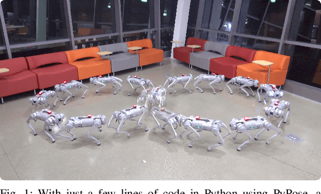
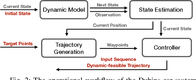
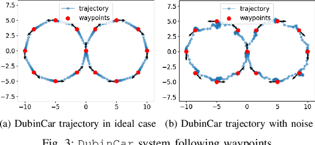
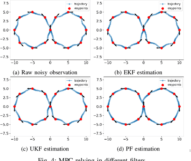
Abstract:PyPose is an open-source library for robot learning. It combines a learning-based approach with physics-based optimization, which enables seamless end-to-end robot learning. It has been used in many tasks due to its meticulously designed application programming interface (API) and efficient implementation. From its initial launch in early 2022, PyPose has experienced significant enhancements, incorporating a wide variety of new features into its platform. To satisfy the growing demand for understanding and utilizing the library and reduce the learning curve of new users, we present the fundamental design principle of the imperative programming interface, and showcase the flexible usage of diverse functionalities and modules using an extremely simple Dubins car example. We also demonstrate that the PyPose can be easily used to navigate a real quadruped robot with a few lines of code.
 Add to Chrome
 Add to Firefox
 Add to Edge