Cunjia Liu
Mr.MSTE: Multi-robot Multi-Source Term Estimation with Wind-Aware Coverage Control
Dec 18, 2025


Abstract:This paper presents a Multi-Robot Multi-Source Term Estimation (MRMSTE) framework that enables teams of mobile robots to collaboratively sample gas concentrations and infer the parameters of an unknown number of airborne releases. The framework is built on a hybrid Bayesian inference scheme that represents the joint multi-source probability density and incorporates physics-informed state transitions, including source birth, removal, and merging induced by atmospheric dispersion. A superposition-based measurement model is naturally accommodated, allowing sparse concentration measurements to be exploited efficiently. To guide robot deployment, we introduce a wind-aware coverage control (WCC) strategy that integrates the evolving multi-source belief with local wind information to prioritize regions of high detection likelihood. Unlike conventional coverage control or information-theoretic planners, WCC explicitly accounts for anisotropic plume transport when modelling sensor performance, leading to more effective sensor placement for multi-source estimation. Monte Carlo studies demonstrate faster convergence and improved separation of individual source beliefs compared to traditional coverage-based strategies and small-scale static sensor networks. Real-world experiments with CO2 releases using TurtleBot platforms further validate the proposed approach, demonstrating its practicality for scalable multi-robot gas-sensing applications.
Beyond Prior Limits: Addressing Distribution Misalignment in Particle Filtering
Jan 30, 2025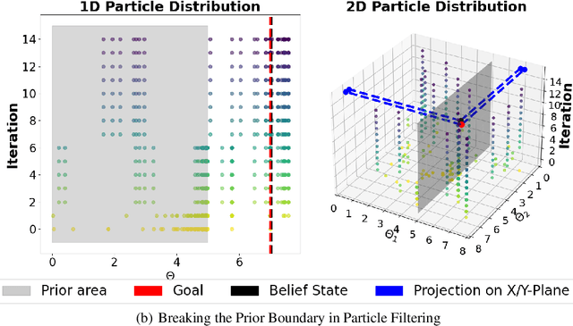
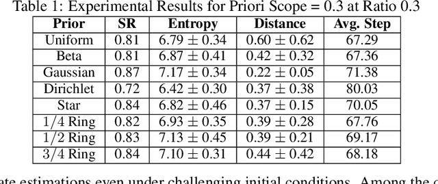
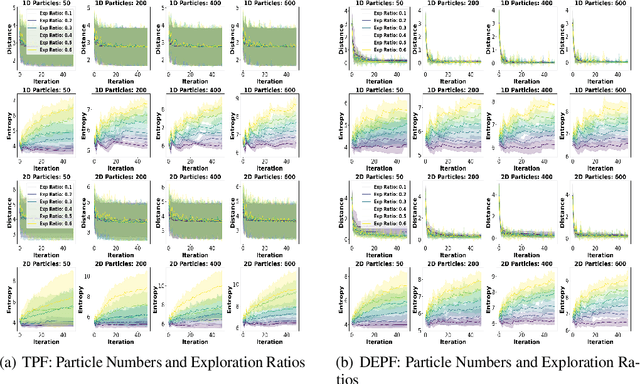
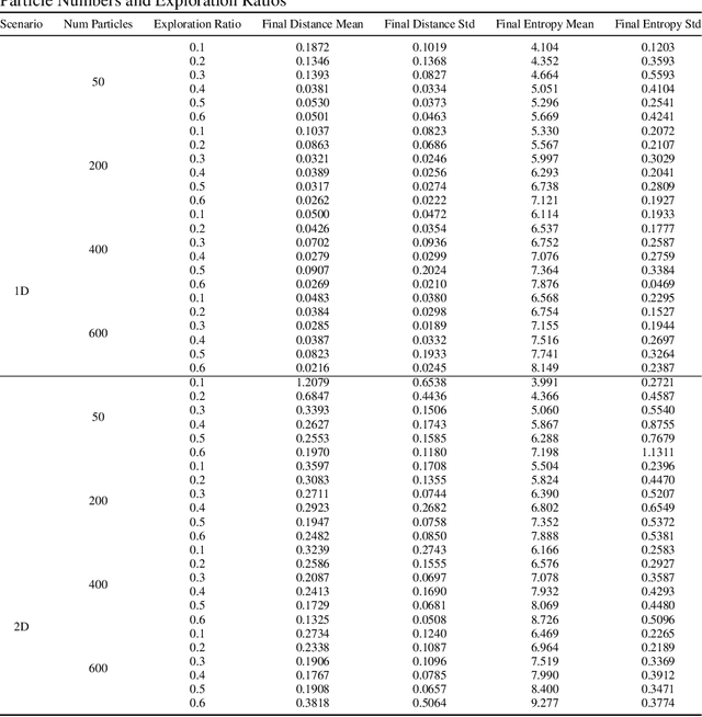
Abstract:Particle filtering is a Bayesian inference method and a fundamental tool in state estimation for dynamic systems, but its effectiveness is often limited by the constraints of the initial prior distribution, a phenomenon we define as the Prior Boundary Phenomenon. This challenge arises when target states lie outside the prior's support, rendering traditional particle filtering methods inadequate for accurate estimation. Although techniques like unbounded priors and larger particle sets have been proposed, they remain computationally prohibitive and lack adaptability in dynamic scenarios. To systematically overcome these limitations, we propose the Diffusion-Enhanced Particle Filtering Framework, which introduces three key innovations: adaptive diffusion through exploratory particles, entropy-driven regularisation to prevent weight collapse, and kernel-based perturbations for dynamic support expansion. These mechanisms collectively enable particle filtering to explore beyond prior boundaries, ensuring robust state estimation for out-of-boundary targets. Theoretical analysis and extensive experiments validate framework's effectiveness, indicating significant improvements in success rates and estimation accuracy across high-dimensional and non-convex scenarios.
Redundant Observer-Based Tracking Control for Object Extraction Using a Cable Connected UAV
Oct 31, 2024


Abstract:A new disturbance observer based control scheme is developed for a quadrotor under the concurrent disturbances from a lightweight elastic tether cable and a lumped vertical disturbance. This elastic tether is unusual as it creates a disturbance proportional to the multicopter's translational movement. This paper takes an observer-based approach to estimate the stiffness coefficient of the cable and uses the system model to update the estimates of the external forces, which are then compensated in the control action. Given that the tethered cable force affects both horizontal channels of the quadrotor and is also coupled with the vertical channel, the proposed disturbance observer is constructed to exploit the redundant measurements across all three channels to jointly estimate the cable stiffness and the vertical disturbance. A pseudo-inverse method is used to determine the observer gain functions, such that the estimation of the two quantities is decoupled and stable. Compared to standard disturbance observers which assume nearly constant disturbances, the proposed approach can quickly adjust its total force estimate as the tethered quadrotor changes its position or tautness of the tether. This is applied to two experiments - a tracking performance test where the multicopter moves under a constant tether strain, and an object extraction test. In the second test, the multicopter manipulates a nonlinear mechanism mimicking the extraction of a wedged object. In both cases, the proposed approach shows significant improvement over standard Disturbance Observer and Extended State Observer approaches. A video summary of the experiments can be found at https://youtu.be/9gKr13WTj-k.
Autonomous Goal Detection and Cessation in Reinforcement Learning: A Case Study on Source Term Estimation
Sep 14, 2024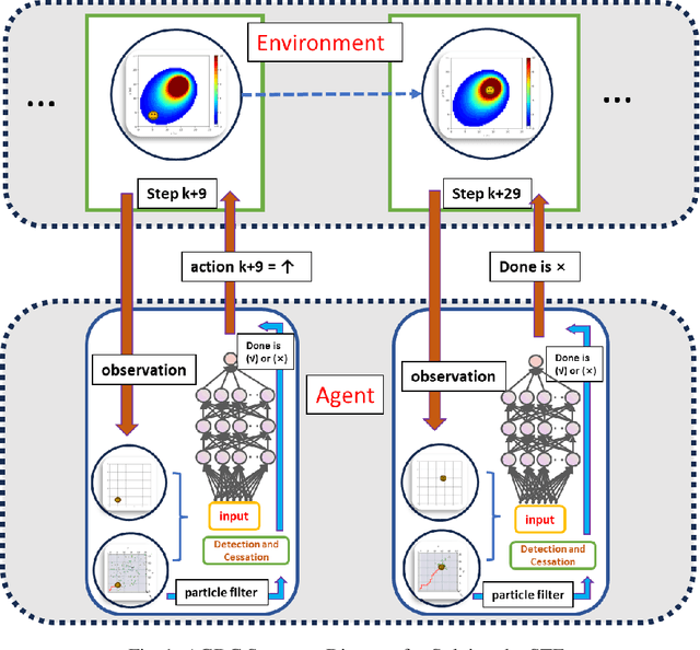
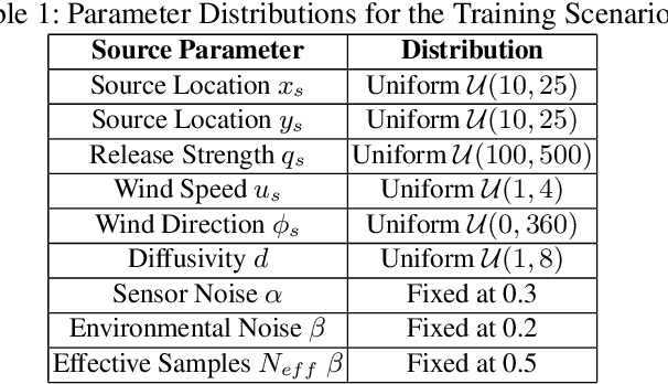
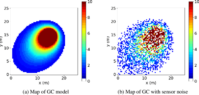
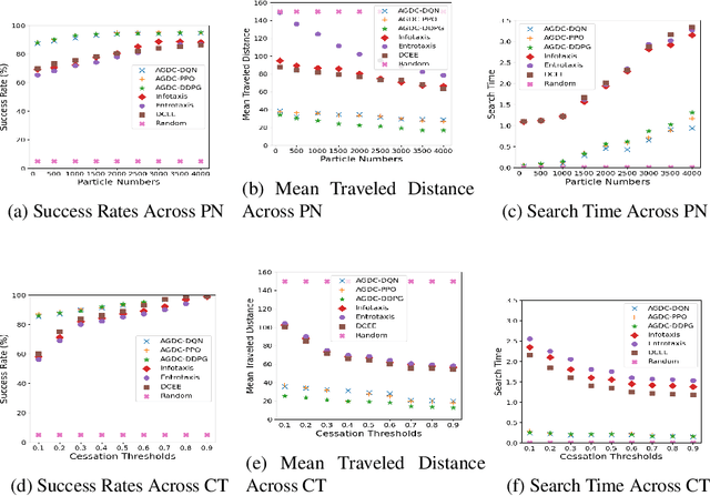
Abstract:Reinforcement Learning has revolutionized decision-making processes in dynamic environments, yet it often struggles with autonomously detecting and achieving goals without clear feedback signals. For example, in a Source Term Estimation problem, the lack of precise environmental information makes it challenging to provide clear feedback signals and to define and evaluate how the source's location is determined. To address this challenge, the Autonomous Goal Detection and Cessation (AGDC) module was developed, enhancing various RL algorithms by incorporating a self-feedback mechanism for autonomous goal detection and cessation upon task completion. Our method effectively identifies and ceases undefined goals by approximating the agent's belief, significantly enhancing the capabilities of RL algorithms in environments with limited feedback. To validate effectiveness of our approach, we integrated AGDC with deep Q-Network, proximal policy optimization, and deep deterministic policy gradient algorithms, and evaluated its performance on the Source Term Estimation problem. The experimental results showed that AGDC-enhanced RL algorithms significantly outperformed traditional statistical methods such as infotaxis, entrotaxis, and dual control for exploitation and exploration, as well as a non-statistical random action selection method. These improvements were evident in terms of success rate, mean traveled distance, and search time, highlighting AGDC's effectiveness and efficiency in complex, real-world scenarios.
Bayesian estimation and reconstruction of marine surface contaminant dispersion
Sep 04, 2023Abstract:Discharge of hazardous substances into the marine environment poses a substantial risk to both public health and the ecosystem. In such incidents, it is imperative to accurately estimate the release strength of the source and reconstruct the spatio-temporal dispersion of the substances based on the collected measurements. In this study, we propose an integrated estimation framework to tackle this challenge, which can be used in conjunction with a sensor network or a mobile sensor for environment monitoring. We employ the fundamental convection-diffusion partial differential equation (PDE) to represent the general dispersion of a physical quantity in a non-uniform flow field. The PDE model is spatially discretised into a linear state-space model using the dynamic transient finite-element method (FEM) so that the characterisation of time-varying dispersion can be cast into the problem of inferring the model states from sensor measurements. We also consider imperfect sensing phenomena, including miss-detection and signal quantisation, which are frequently encountered when using a sensor network. This complicated sensor process introduces nonlinearity into the Bayesian estimation process. A Rao-Blackwellised particle filter (RBPF) is designed to provide an effective solution by exploiting the linear structure of the state-space model, whereas the nonlinearity of the measurement model can be handled by Monte Carlo approximation with particles. The proposed framework is validated using a simulated oil spill incident in the Baltic sea with real ocean flow data. The results show the efficacy of the developed spatio-temporal dispersion model and estimation schemes in the presence of imperfect measurements. Moreover, the parameter selection process is discussed, along with some comparison studies to illustrate the advantages of the proposed algorithm over existing methods.
Motion Planning for Aerial Pick-and-Place based on Geometric Feasibility Constraints
Jun 08, 2023Abstract:This paper studies the motion planning problem of the pick-and-place of an aerial manipulator that consists of a quadcopter flying base and a Delta arm. We propose a novel partially decoupled motion planning framework to solve this problem. Compared to the state-of-the-art approaches, the proposed one has two novel features. First, it does not suffer from increased computation in high-dimensional configuration spaces. That is because it calculates the trajectories of the quadcopter base and the end-effector separately in the Cartesian space based on proposed geometric feasibility constraints. The geometric feasibility constraints can ensure the resulting trajectories satisfy the aerial manipulator's geometry. Second, collision avoidance for the Delta arm is achieved through an iterative approach based on a pinhole mapping method, so that the feasible trajectory can be found in an efficient manner. The proposed approach is verified by three experiments on a real aerial manipulation platform. The experimental results show the effectiveness of the proposed method for the aerial pick-and-place task.
Structurally aware 3D gas distribution mapping using belief propagation: a real-time algorithm for robotic deployment
Dec 14, 2022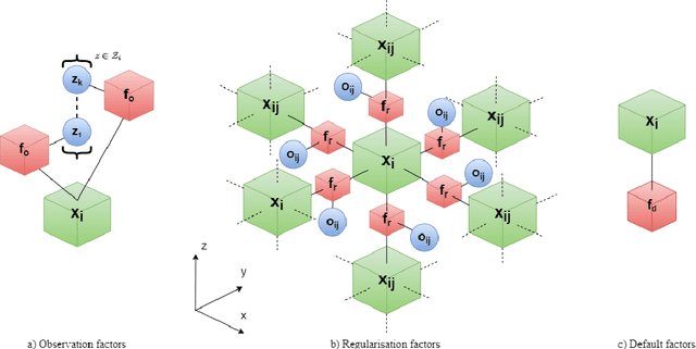
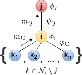
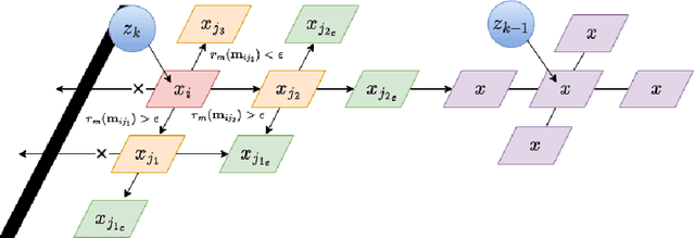
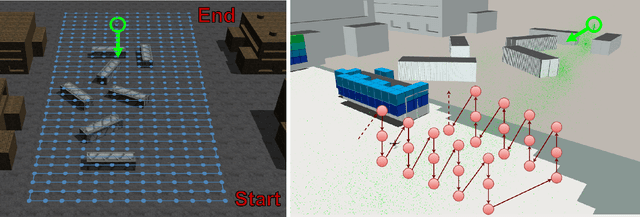
Abstract:This paper proposes a new 3D gas distribution mapping technique based on the local message passing of Gaussian belief propagation that is capable of resolving in real time, concentration estimates in 3D space whilst accounting for the obstacle information within the scenario, the first of its kind in the literature. The gas mapping problem is formulated as a 3D factor graph of Gaussian potentials, the connections of which are conditioned on local occupancy values. The Gaussian belief propagation framework is introduced as the solver and a new hybrid message scheduler is introduced to increase the rate of convergence. The factor graph problem is then redesigned as a dynamically expanding inference task, coupling the information of consecutive gas measurements with local spatial structure obtained by the robot. The proposed algorithm is compared to the state of the art methods in 2D and 3D simulations and is found to resolve distribution maps orders of magnitude quicker than typical direct solvers. The proposed framework is then deployed for the first time onboard a ground robot in a 3D mapping and exploration task. The system is shown to be able to resolve multiple sensor inputs and output high resolution 3D gas distribution maps in a GPS denied cluttered scenario in real time. This online inference of complicated plume structures provides a new layer of contextual information over its 2D counterparts and enables autonomous systems to take advantage of real time estimates to inform potential next best sampling locations.
Potential Auto-driving Threat: Universal Rain-removal Attack
Nov 18, 2022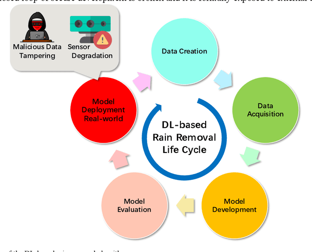
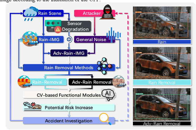
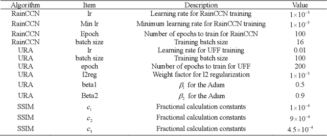
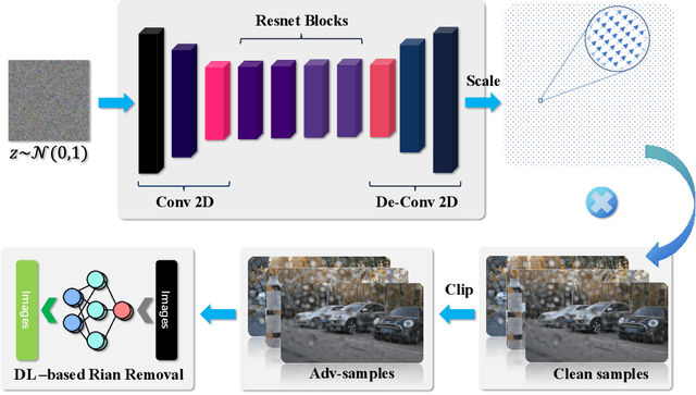
Abstract:The problem of robustness in adverse weather conditions is considered a significant challenge for computer vision algorithms in the applicants of autonomous driving. Image rain removal algorithms are a general solution to this problem. They find a deep connection between raindrops/rain-streaks and images by mining the hidden features and restoring information about the rain-free environment based on the powerful representation capabilities of neural networks. However, previous research has focused on architecture innovations and has yet to consider the vulnerability issues that already exist in neural networks. This research gap hints at a potential security threat geared toward the intelligent perception of autonomous driving in the rain. In this paper, we propose a universal rain-removal attack (URA) on the vulnerability of image rain-removal algorithms by generating a non-additive spatial perturbation that significantly reduces the similarity and image quality of scene restoration. Notably, this perturbation is difficult to recognise by humans and is also the same for different target images. Thus, URA could be considered a critical tool for the vulnerability detection of image rain-removal algorithms. It also could be developed as a real-world artificial intelligence attack method. Experimental results show that URA can reduce the scene repair capability by 39.5% and the image generation quality by 26.4%, targeting the state-of-the-art (SOTA) single-image rain-removal algorithms currently available.
Autonomous search of an airborne release in urban environments using informed tree planning
Sep 08, 2021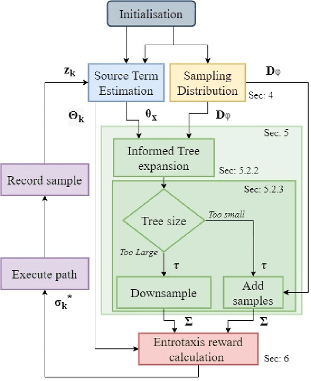
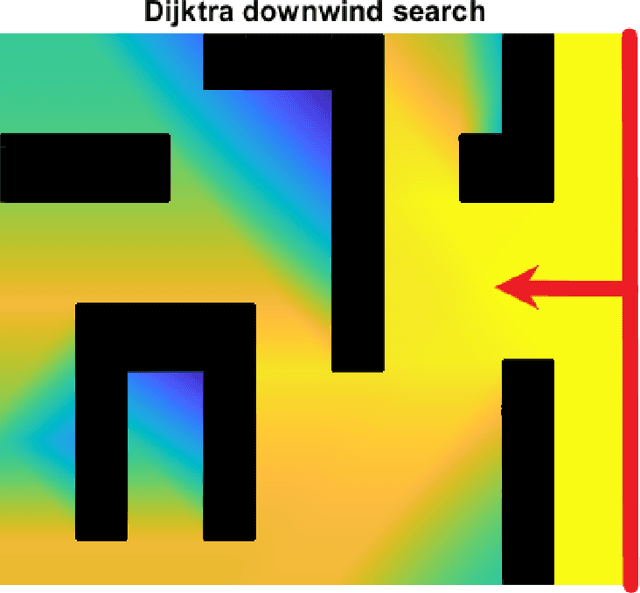
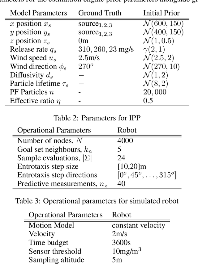

Abstract:The use of autonomous vehicles for chemical source localisation is a key enabling tool for disaster response teams to safely and efficiently deal with chemical emergencies. Whilst much work has been performed on source localisation using autonomous systems, most previous works have assumed an open environment or employed simplistic obstacle avoidance, separate to the estimation procedure. In this paper, we explore the coupling of the path planning task for both source term estimation and obstacle avoidance in a holistic framework. The proposed system intelligently produces potential gas sampling locations based on the current estimation of the wind field and the local map. Then a tree search is performed to generate paths toward the estimated source location that traverse around any obstacles and still allow for exploration of potentially superior sampling locations. The proposed informed tree planning algorithm is then tested against the Entrotaxis technique in a series of high fidelity simulations. The proposed system is found to reduce source position error far more efficiently than Entrotaxis in a feature rich environment, whilst also exhibiting vastly more consistent and robust results.
Dual Control for Exploitation and Exploration (DCEE) in Autonomous Search
Dec 11, 2020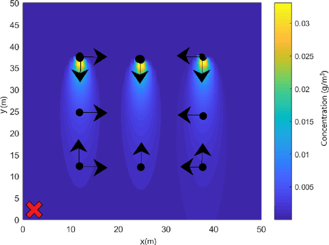
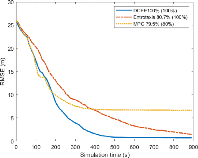
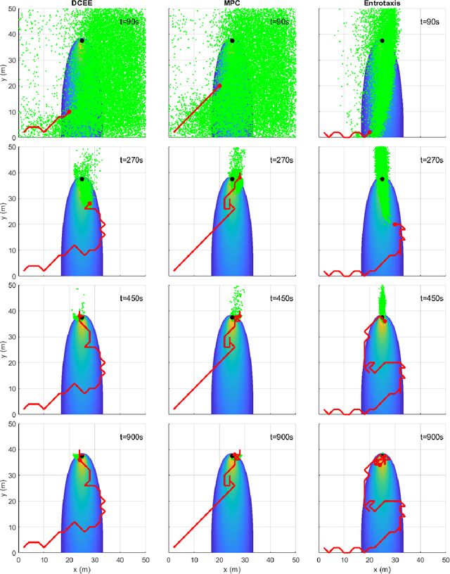
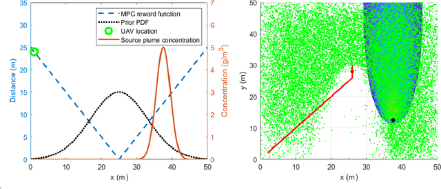
Abstract:This paper proposes an optimal autonomous search framework, namely Dual Control for Exploration and Exploitation (DCEE), for a target at unknown location in an unknown environment. Source localisation is to find sources of atmospheric hazardous material release in a partially unknown environment. This paper proposes a control theoretic approach to this autonomous search problem. To cope with an unknown target location, at each step, the target location is estimated by Bayesian inference. Then a control action is taken to minimise the error between future robot position and the hypothesised future estimation of the target location. The latter is generated by hypothesised measurements at the corresponding future robot positions (due to the control action) with the current estimation of the target location as a prior. It shows that this approach can take into account both the error between the next robot position and the estimate of the target location, and the uncertainty of the estimate. This approach is further extended to the case with not only an unknown source location, but also an unknown local environment (e.g. wind speed and direction). Different from current information theoretic approaches, this new control theoretic approach achieves the optimal trade-off between exploitation and exploration in a unknown environment with an unknown target by driving the robot moving towards estimated target location while reducing its estimation uncertainty. This scheme is implemented using particle filtering on a mobile robot. Simulation and experimental studies demonstrate promising performance of the proposed approach. The relationships between the proposed approach, informative path planning, dual control, and classic model predictive control are discussed and compared.
 Add to Chrome
 Add to Firefox
 Add to Edge