Claire Monteleoni
ARCHES
STIPP: Space-time in situ postprocessing over the French Alps using proper scoring rules
Jan 06, 2026Abstract:We propose Space-time in situ postprocessing (STIPP), a machine learning model that generates spatio-temporally consistent weather forecasts for a network of station locations. Gridded forecasts from classical numerical weather prediction or data-driven models often lack the necessary precision due to unresolved local effects. Typical statistical postprocessing methods correct these biases, but often degrade spatio-temporal correlation structures in doing so. Recent works based on generative modeling successfully improve spatial correlation structures but have to forecast every lead time independently. In contrast, STIPP makes joint spatio-temporal forecasts which have increased accuracy for surface temperature, wind, relative humidity and precipitation when compared to baseline methods. It makes hourly ensemble predictions given only a six-hourly deterministic forecast, blending the boundaries of postprocessing and temporal interpolation. By leveraging a multivariate proper scoring rule for training, STIPP contributes to ongoing work data-driven atmospheric models supervised only with distribution marginals.
SerpentFlow: Generative Unpaired Domain Alignment via Shared-Structure Decomposition
Jan 05, 2026Abstract:Domain alignment refers broadly to learning correspondences between data distributions from distinct domains. In this work, we focus on a setting where domains share underlying structural patterns despite differences in their specific realizations. The task is particularly challenging in the absence of paired observations, which removes direct supervision across domains. We introduce a generative framework, called SerpentFlow (SharEd-structuRe decomPosition for gEnerative domaiN adapTation), for unpaired domain alignment. SerpentFlow decomposes data within a latent space into a shared component common to both domains and a domain-specific one. By isolating the shared structure and replacing the domain-specific component with stochastic noise, we construct synthetic training pairs between shared representations and target-domain samples, thereby enabling the use of conditional generative models that are traditionally restricted to paired settings. We apply this approach to super-resolution tasks, where the shared component naturally corresponds to low-frequency content while high-frequency details capture domain-specific variability. The cutoff frequency separating low- and high-frequency components is determined automatically using a classifier-based criterion, ensuring a data-driven and domain-adaptive decomposition. By generating pseudo-pairs that preserve low-frequency structures while injecting stochastic high-frequency realizations, we learn the conditional distribution of the target domain given the shared representation. We implement SerpentFlow using Flow Matching as the generative pipeline, although the framework is compatible with other conditional generative approaches. Experiments on synthetic images, physical process simulations, and a climate downscaling task demonstrate that the method effectively reconstructs high-frequency structures consistent with underlying low-frequency patterns, supporting shared-structure decomposition as an effective strategy for unpaired domain alignment.
ArchesClimate: Probabilistic Decadal Ensemble Generation With Flow Matching
Sep 19, 2025Abstract:Climate projections have uncertainties related to components of the climate system and their interactions. A typical approach to quantifying these uncertainties is to use climate models to create ensembles of repeated simulations under different initial conditions. Due to the complexity of these simulations, generating such ensembles of projections is computationally expensive. In this work, we present ArchesClimate, a deep learning-based climate model emulator that aims to reduce this cost. ArchesClimate is trained on decadal hindcasts of the IPSL-CM6A-LR climate model at a spatial resolution of approximately 2.5x1.25 degrees. We train a flow matching model following ArchesWeatherGen, which we adapt to predict near-term climate. Once trained, the model generates states at a one-month lead time and can be used to auto-regressively emulate climate model simulations of any length. We show that for up to 10 years, these generations are stable and physically consistent. We also show that for several important climate variables, ArchesClimate generates simulations that are interchangeable with the IPSL model. This work suggests that climate model emulators could significantly reduce the cost of climate model simulations.
Incentivized Lipschitz Bandits
Aug 26, 2025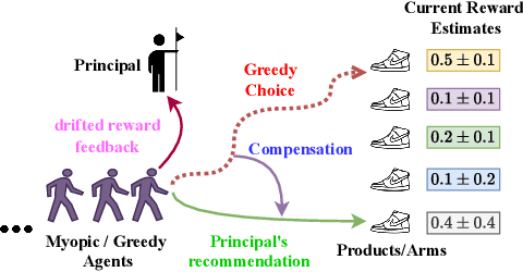
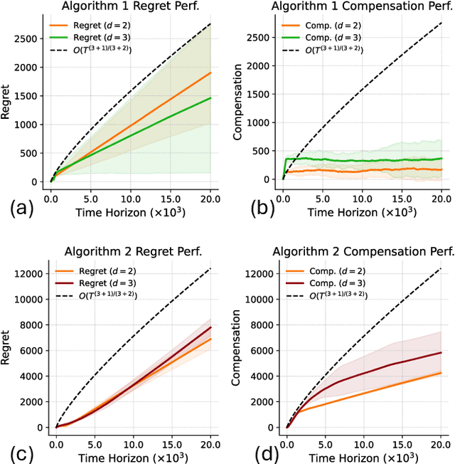
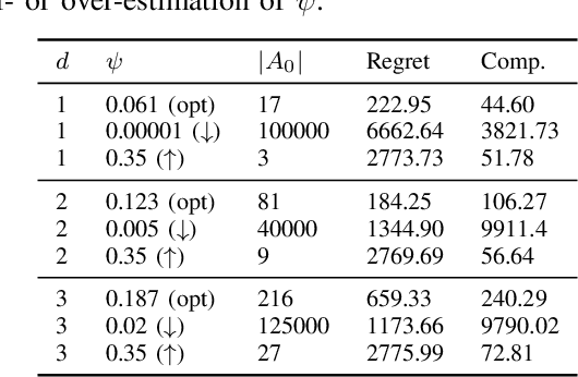
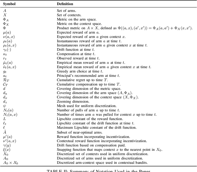
Abstract:We study incentivized exploration in multi-armed bandit (MAB) settings with infinitely many arms modeled as elements in continuous metric spaces. Unlike classical bandit models, we consider scenarios where the decision-maker (principal) incentivizes myopic agents to explore beyond their greedy choices through compensation, but with the complication of reward drift--biased feedback arising due to the incentives. We propose novel incentivized exploration algorithms that discretize the infinite arm space uniformly and demonstrate that these algorithms simultaneously achieve sublinear cumulative regret and sublinear total compensation. Specifically, we derive regret and compensation bounds of $\Tilde{O}(T^{d+1/d+2})$, with $d$ representing the covering dimension of the metric space. Furthermore, we generalize our results to contextual bandits, achieving comparable performance guarantees. We validate our theoretical findings through numerical simulations.
Generating ensembles of spatially-coherent in-situ forecasts using flow matching
Apr 04, 2025Abstract:We propose a machine-learning-based methodology for in-situ weather forecast postprocessing that is both spatially coherent and multivariate. Compared to previous work, our Flow MAtching Postprocessing (FMAP) better represents the correlation structures of the observations distribution, while also improving marginal performance at the stations. FMAP generates forecasts that are not bound to what is already modeled by the underlying gridded prediction and can infer new correlation structures from data. The resulting model can generate an arbitrary number of forecasts from a limited number of numerical simulations, allowing for low-cost forecasting systems. A single training is sufficient to perform postprocessing at multiple lead times, in contrast with other methods which use multiple trained networks at generation time. This work details our methodology, including a spatial attention transformer backbone trained within a flow matching generative modeling framework. FMAP shows promising performance in experiments on the EUPPBench dataset, forecasting surface temperature and wind gust values at station locations in western Europe up to five-day lead times.
Deep Clustering via Probabilistic Ratio-Cut Optimization
Feb 05, 2025Abstract:We propose a novel approach for optimizing the graph ratio-cut by modeling the binary assignments as random variables. We provide an upper bound on the expected ratio-cut, as well as an unbiased estimate of its gradient, to learn the parameters of the assignment variables in an online setting. The clustering resulting from our probabilistic approach (PRCut) outperforms the Rayleigh quotient relaxation of the combinatorial problem, its online learning extensions, and several widely used methods. We demonstrate that the PRCut clustering closely aligns with the similarity measure and can perform as well as a supervised classifier when label-based similarities are provided. This novel approach can leverage out-of-the-box self-supervised representations to achieve competitive performance and serve as an evaluation method for the quality of these representations.
* Proceedings of the 28th International Conference on Artificial Intelligence and Statistics (AISTATS) 2025, Mai Khao, Thailand. PMLR: Volume 258
Where Did Your Model Learn That? Label-free Influence for Self-supervised Learning
Dec 22, 2024Abstract:Self-supervised learning (SSL) has revolutionized learning from large-scale unlabeled datasets, yet the intrinsic relationship between pretraining data and the learned representations remains poorly understood. Traditional supervised learning benefits from gradient-based data attribution tools like influence functions that measure the contribution of an individual data point to model predictions. However, existing definitions of influence rely on labels, making them unsuitable for SSL settings. We address this gap by introducing Influence-SSL, a novel and label-free approach for defining influence functions tailored to SSL. Our method harnesses the stability of learned representations against data augmentations to identify training examples that help explain model predictions. We provide both theoretical foundations and empirical evidence to show the utility of Influence-SSL in analyzing pre-trained SSL models. Our analysis reveals notable differences in how SSL models respond to influential data compared to supervised models. Finally, we validate the effectiveness of Influence-SSL through applications in duplicate detection, outlier identification and fairness analysis. Code is available at: \url{https://github.com/cryptonymous9/Influence-SSL}.
ArchesWeather & ArchesWeatherGen: a deterministic and generative model for efficient ML weather forecasting
Dec 17, 2024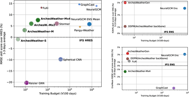
Abstract:Weather forecasting plays a vital role in today's society, from agriculture and logistics to predicting the output of renewable energies, and preparing for extreme weather events. Deep learning weather forecasting models trained with the next state prediction objective on ERA5 have shown great success compared to numerical global circulation models. However, for a wide range of applications, being able to provide representative samples from the distribution of possible future weather states is critical. In this paper, we propose a methodology to leverage deterministic weather models in the design of probabilistic weather models, leading to improved performance and reduced computing costs. We first introduce \textbf{ArchesWeather}, a transformer-based deterministic model that improves upon Pangu-Weather by removing overrestrictive inductive priors. We then design a probabilistic weather model called \textbf{ArchesWeatherGen} based on flow matching, a modern variant of diffusion models, that is trained to project ArchesWeather's predictions to the distribution of ERA5 weather states. ArchesWeatherGen is a true stochastic emulator of ERA5 and surpasses IFS ENS and NeuralGCM on all WeatherBench headline variables (except for NeuralGCM's geopotential). Our work also aims to democratize the use of deterministic and generative machine learning models in weather forecasting research, with academic computing resources. All models are trained at 1.5{\deg} resolution, with a training budget of $\sim$9 V100 days for ArchesWeather and $\sim$45 V100 days for ArchesWeatherGen. For inference, ArchesWeatherGen generates 15-day weather trajectories at a rate of 1 minute per ensemble member on a A100 GPU card. To make our work fully reproducible, our code and models are open source, including the complete pipeline for data preparation, training, and evaluation, at https://github.com/INRIA/geoarches .
Mixing Natural and Synthetic Images for Robust Self-Supervised Representations
Jun 18, 2024


Abstract:This paper introduces DiffMix, a new self-supervised learning (SSL) pre-training framework that combines real and synthetic images. Unlike traditional SSL methods that predominantly use real images, DiffMix uses a variant of Stable Diffusion to replace an augmented instance of a real image, facilitating the learning of cross real-synthetic image representations. The key insight is that while SSL methods trained solely on synthetic images underperform compared to those trained on real images, a blended training approach using both real and synthetic images leads to more robust and adaptable representations. Experiments demonstrate that DiffMix enhances the SSL methods SimCLR, BarlowTwins, and DINO, across various robustness datasets and domain transfer tasks. DiffMix boosts SimCLR's accuracy on ImageNet-1K by 4.56\%. These results challenge the notion that high-quality real images are crucial for SSL pre-training by showing that lower quality synthetic images can also produce strong representations. DiffMix also reduces the need for image augmentations in SSL, offering new optimization strategies.
ArchesWeather: An efficient AI weather forecasting model at 1.5° resolution
May 23, 2024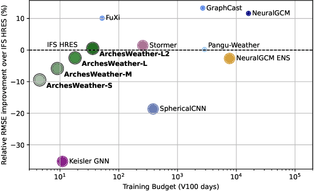
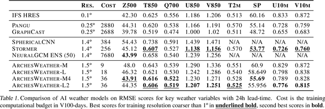
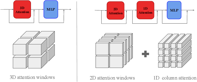
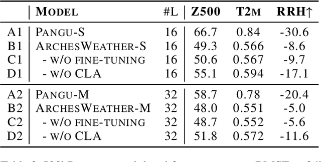
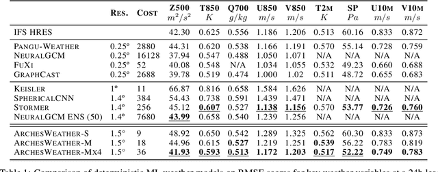
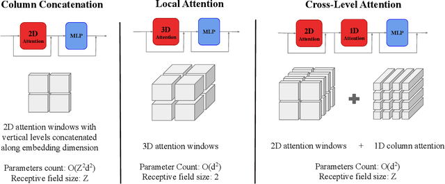
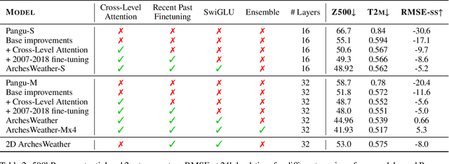
Abstract:One of the guiding principles for designing AI-based weather forecasting systems is to embed physical constraints as inductive priors in the neural network architecture. A popular prior is locality, where the atmospheric data is processed with local neural interactions, like 3D convolutions or 3D local attention windows as in Pangu-Weather. On the other hand, some works have shown great success in weather forecasting without this locality principle, at the cost of a much higher parameter count. In this paper, we show that the 3D local processing in Pangu-Weather is computationally sub-optimal. We design ArchesWeather, a transformer model that combines 2D attention with a column-wise attention-based feature interaction module, and demonstrate that this design improves forecasting skill. ArchesWeather is trained at 1.5{\deg} resolution and 24h lead time, with a training budget of a few GPU-days and a lower inference cost than competing methods. An ensemble of two of our best models shows competitive RMSE scores with the IFS HRES and outperforms the 1.4{\deg} 50-members NeuralGCM ensemble for one day ahead forecasting. Code and models will be made publicly available at https://github.com/gcouairon/ArchesWeather.
 Add to Chrome
 Add to Firefox
 Add to Edge