Aneesh Subramanian
Building Machine Learning Challenges for Anomaly Detection in Science
Mar 03, 2025


Abstract:Scientific discoveries are often made by finding a pattern or object that was not predicted by the known rules of science. Oftentimes, these anomalous events or objects that do not conform to the norms are an indication that the rules of science governing the data are incomplete, and something new needs to be present to explain these unexpected outliers. The challenge of finding anomalies can be confounding since it requires codifying a complete knowledge of the known scientific behaviors and then projecting these known behaviors on the data to look for deviations. When utilizing machine learning, this presents a particular challenge since we require that the model not only understands scientific data perfectly but also recognizes when the data is inconsistent and out of the scope of its trained behavior. In this paper, we present three datasets aimed at developing machine learning-based anomaly detection for disparate scientific domains covering astrophysics, genomics, and polar science. We present the different datasets along with a scheme to make machine learning challenges around the three datasets findable, accessible, interoperable, and reusable (FAIR). Furthermore, we present an approach that generalizes to future machine learning challenges, enabling the possibility of large, more compute-intensive challenges that can ultimately lead to scientific discovery.
Correlation to Causation: A Causal Deep Learning Framework for Arctic Sea Ice Prediction
Mar 03, 2025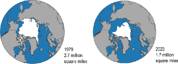
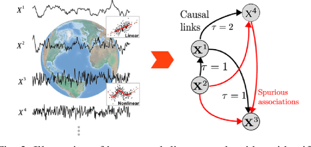

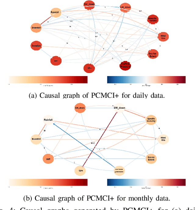
Abstract:Traditional machine learning and deep learning techniques rely on correlation-based learning, often failing to distinguish spurious associations from true causal relationships, which limits robustness, interpretability, and generalizability. To address these challenges, we propose a causality-driven deep learning framework that integrates Multivariate Granger Causality (MVGC) and PCMCI+ causal discovery algorithms with a hybrid deep learning architecture. Using 43 years (1979-2021) of daily and monthly Arctic Sea Ice Extent (SIE) and ocean-atmospheric datasets, our approach identifies causally significant factors, prioritizes features with direct influence, reduces feature overhead, and improves computational efficiency. Experiments demonstrate that integrating causal features enhances the deep learning model's predictive accuracy and interpretability across multiple lead times. Beyond SIE prediction, the proposed framework offers a scalable solution for dynamic, high-dimensional systems, advancing both theoretical understanding and practical applications in predictive modeling.
Towards Kriging-informed Conditional Diffusion for Regional Sea-Level Data Downscaling
Oct 21, 2024


Abstract:Given coarser-resolution projections from global climate models or satellite data, the downscaling problem aims to estimate finer-resolution regional climate data, capturing fine-scale spatial patterns and variability. Downscaling is any method to derive high-resolution data from low-resolution variables, often to provide more detailed and local predictions and analyses. This problem is societally crucial for effective adaptation, mitigation, and resilience against significant risks from climate change. The challenge arises from spatial heterogeneity and the need to recover finer-scale features while ensuring model generalization. Most downscaling methods \cite{Li2020} fail to capture the spatial dependencies at finer scales and underperform on real-world climate datasets, such as sea-level rise. We propose a novel Kriging-informed Conditional Diffusion Probabilistic Model (Ki-CDPM) to capture spatial variability while preserving fine-scale features. Experimental results on climate data show that our proposed method is more accurate than state-of-the-art downscaling techniques.
Time Series Classification of Supraglacial Lakes Evolution over Greenland Ice Sheet
Oct 08, 2024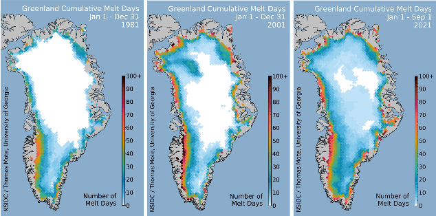
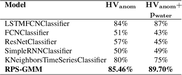
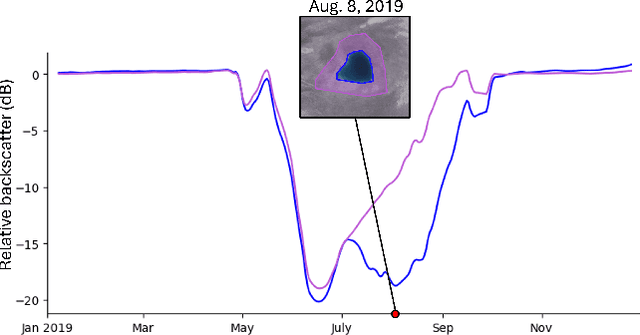

Abstract:The Greenland Ice Sheet (GrIS) has emerged as a significant contributor to global sea level rise, primarily due to increased meltwater runoff. Supraglacial lakes, which form on the ice sheet surface during the summer months, can impact ice sheet dynamics and mass loss; thus, better understanding these lakes' seasonal evolution and dynamics is an important task. This study presents a computationally efficient time series classification approach that uses Gaussian Mixture Models (GMMs) of the Reconstructed Phase Spaces (RPSs) to identify supraglacial lakes based on their seasonal evolution: 1) those that refreeze at the end of the melt season, 2) those that drain during the melt season, and 3) those that become buried, remaining liquid insulated a few meters beneath the surface. Our approach uses time series data from the Sentinel-1 and Sentinel-2 satellites, which utilize microwave and visible radiation, respectively. Evaluated on a GrIS-wide dataset, the RPS-GMM model, trained on a single representative sample per class, achieves 85.46% accuracy with Sentinel-1 data alone and 89.70% with combined Sentinel-1 and Sentinel-2 data. This performance significantly surpasses existing machine learning and deep learning models which require a large training data. The results demonstrate the robustness of the RPS-GMM model in capturing the complex temporal dynamics of supraglacial lakes with minimal training data.
Reducing Uncertainty in Sea-level Rise Prediction: A Spatial-variability-aware Approach
Oct 19, 2023


Abstract:Given multi-model ensemble climate projections, the goal is to accurately and reliably predict future sea-level rise while lowering the uncertainty. This problem is important because sea-level rise affects millions of people in coastal communities and beyond due to climate change's impacts on polar ice sheets and the ocean. This problem is challenging due to spatial variability and unknowns such as possible tipping points (e.g., collapse of Greenland or West Antarctic ice-shelf), climate feedback loops (e.g., clouds, permafrost thawing), future policy decisions, and human actions. Most existing climate modeling approaches use the same set of weights globally, during either regression or deep learning to combine different climate projections. Such approaches are inadequate when different regions require different weighting schemes for accurate and reliable sea-level rise predictions. This paper proposes a zonal regression model which addresses spatial variability and model inter-dependency. Experimental results show more reliable predictions using the weights learned via this approach on a regional scale.
STint: Self-supervised Temporal Interpolation for Geospatial Data
Aug 31, 2023

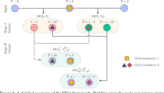
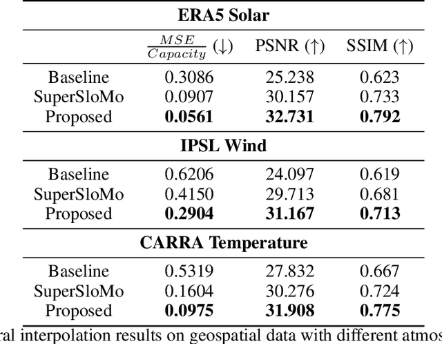
Abstract:Supervised and unsupervised techniques have demonstrated the potential for temporal interpolation of video data. Nevertheless, most prevailing temporal interpolation techniques hinge on optical flow, which encodes the motion of pixels between video frames. On the other hand, geospatial data exhibits lower temporal resolution while encompassing a spectrum of movements and deformations that challenge several assumptions inherent to optical flow. In this work, we propose an unsupervised temporal interpolation technique, which does not rely on ground truth data or require any motion information like optical flow, thus offering a promising alternative for better generalization across geospatial domains. Specifically, we introduce a self-supervised technique of dual cycle consistency. Our proposed technique incorporates multiple cycle consistency losses, which result from interpolating two frames between consecutive input frames through a series of stages. This dual cycle consistent constraint causes the model to produce intermediate frames in a self-supervised manner. To the best of our knowledge, this is the first attempt at unsupervised temporal interpolation without the explicit use of optical flow. Our experimental evaluations across diverse geospatial datasets show that STint significantly outperforms existing state-of-the-art methods for unsupervised temporal interpolation.
 Add to Chrome
 Add to Firefox
 Add to Edge