Trenton Tabor
Carnegie Mellon University
Software Engineering for Robotics: Future Research Directions; Report from the 2023 Workshop on Software Engineering for Robotics
Jan 22, 2024Abstract:Robots are experiencing a revolution as they permeate many aspects of our daily lives, from performing house maintenance to infrastructure inspection, from efficiently warehousing goods to autonomous vehicles, and more. This technical progress and its impact are astounding. This revolution, however, is outstripping the capabilities of existing software development processes, techniques, and tools, which largely have remained unchanged for decades. These capabilities are ill-suited to handling the challenges unique to robotics software such as dealing with a wide diversity of domains, heterogeneous hardware, programmed and learned components, complex physical environments captured and modeled with uncertainty, emergent behaviors that include human interactions, and scalability demands that span across multiple dimensions. Looking ahead to the need to develop software for robots that are ever more ubiquitous, autonomous, and reliant on complex adaptive components, hardware, and data, motivated an NSF-sponsored community workshop on the subject of Software Engineering for Robotics, held in Detroit, Michigan in October 2023. The goal of the workshop was to bring together thought leaders across robotics and software engineering to coalesce a community, and identify key problems in the area of SE for robotics that that community should aim to solve over the next 5 years. This report serves to summarize the motivation, activities, and findings of that workshop, in particular by articulating the challenges unique to robot software, and identifying a vision for fruitful near-term research directions to tackle them.
UGV-UAV Object Geolocation in Unstructured Environments
Jan 14, 2022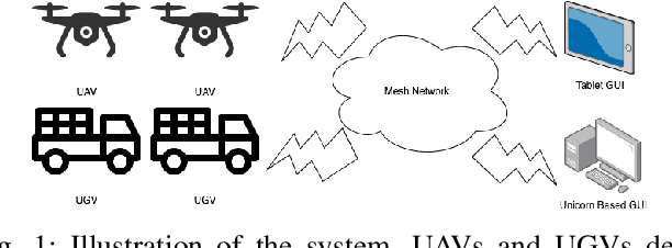
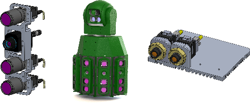
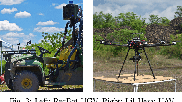
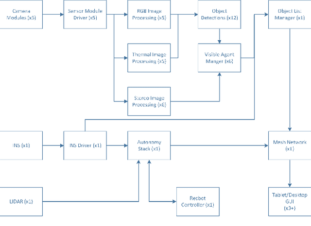
Abstract:A robotic system of multiple unmanned ground vehicles (UGVs) and unmanned aerial vehicles (UAVs) has the potential for advancing autonomous object geolocation performance. Much research has focused on algorithmic improvements on individual components, such as navigation, motion planning, and perception. In this paper, we present a UGV-UAV object detection and geolocation system, which performs perception, navigation, and planning autonomously in real scale in unstructured environment. We designed novel sensor pods equipped with multispectral (visible, near-infrared, thermal), high resolution (181.6 Mega Pixels), stereo (near-infrared pair), wide field of view (192 degree HFOV) array. We developed a novel on-board software-hardware architecture to process the high volume sensor data in real-time, and we built a custom AI subsystem composed of detection, tracking, navigation, and planning for autonomous objects geolocation in real-time. This research is the first real scale demonstration of such high speed data processing capability. Our novel modular sensor pod can boost relevant computer vision and machine learning research. Our novel hardware-software architecture is a solid foundation for system-level and component-level research. Our system is validated through data-driven offline tests as well as a series of field tests in unstructured environments. We present quantitative results as well as discussions on key robotic system level challenges which manifest when we build and test the system. This system is the first step toward a UGV-UAV cooperative reconnaissance system in the future.
SBEVNet: End-to-End Deep Stereo Layout Estimation
May 25, 2021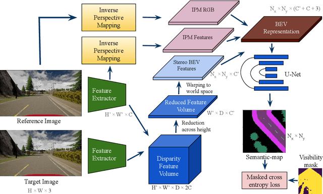
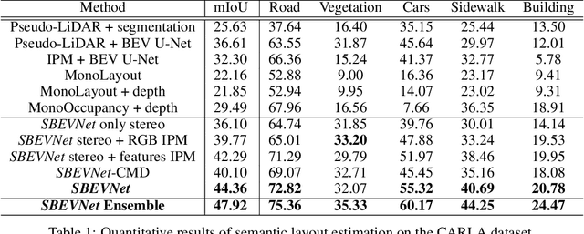
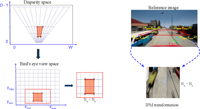
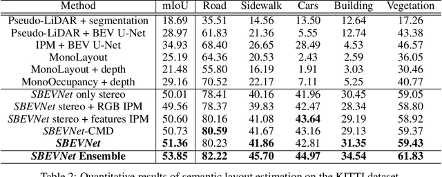
Abstract:Accurate layout estimation is crucial for planning and navigation in robotics applications, such as self-driving. In this paper, we introduce the Stereo Bird's Eye ViewNetwork (SBEVNet), a novel supervised end-to-end framework for estimation of bird's eye view layout from a pair of stereo images. Although our network reuses some of the building blocks from the state-of-the-art deep learning networks for disparity estimation, we show that explicit depth estimation is neither sufficient nor necessary. Instead, the learning of a good internal bird's eye view feature representation is effective for layout estimation. Specifically, we first generate a disparity feature volume using the features of the stereo images and then project it to the bird's eye view coordinates. This gives us coarse-grained information about the scene structure. We also apply inverse perspective mapping (IPM) to map the input images and their features to the bird's eye view. This gives us fine-grained texture information. Concatenating IPM features with the projected feature volume creates a rich bird's eye view representation which is useful for spatial reasoning. We use this representation to estimate the BEV semantic map. Additionally, we show that using the IPM features as a supervisory signal for stereo features can give an improvement in performance. We demonstrate our approach on two datasets:the KITTI dataset and a synthetically generated dataset from the CARLA simulator. For both of these datasets, we establish state-of-the-art performance compared to baseline techniques.
Comparing Apples and Oranges: Off-Road Pedestrian Detection on the NREC Agricultural Person-Detection Dataset
Oct 26, 2017

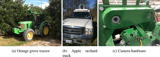

Abstract:Person detection from vehicles has made rapid progress recently with the advent of multiple highquality datasets of urban and highway driving, yet no large-scale benchmark is available for the same problem in off-road or agricultural environments. Here we present the NREC Agricultural Person-Detection Dataset to spur research in these environments. It consists of labeled stereo video of people in orange and apple orchards taken from two perception platforms (a tractor and a pickup truck), along with vehicle position data from RTK GPS. We define a benchmark on part of the dataset that combines a total of 76k labeled person images and 19k sampled person-free images. The dataset highlights several key challenges of the domain, including varying environment, substantial occlusion by vegetation, people in motion and in non-standard poses, and people seen from a variety of distances; meta-data are included to allow targeted evaluation of each of these effects. Finally, we present baseline detection performance results for three leading approaches from urban pedestrian detection and our own convolutional neural network approach that benefits from the incorporation of additional image context. We show that the success of existing approaches on urban data does not transfer directly to this domain.
 Add to Chrome
 Add to Firefox
 Add to Edge