Stefan Auer
A Deep Dive into OpenStreetMap Research Since its Inception (2008-2024): Contributors, Topics, and Future Trends
Jan 14, 2026Abstract:OpenStreetMap (OSM) has transitioned from a pioneering volunteered geographic information (VGI) project into a global, multi-disciplinary research nexus. This study presents a bibliometric and systematic analysis of the OSM research landscape, examining its development trajectory and key driving forces. By evaluating 1,926 publications from the Web of Science (WoS) Core Collection and 782 State of the Map (SotM) presentations up to June 2024, we quantify publication growth, collaboration patterns, and thematic evolution. Results demonstrate simultaneous consolidation and diversification within the field. While a stable core of contributors continues to anchor OSM research, themes have shifted from initial concerns over data production and quality toward advanced analytical and applied uses. Comparative analysis of OSM-related research in WoS and SotM reveals distinct but complementary agendas between scholars and the OSM community. Building on these findings, we identify six emerging research directions and discuss how evolving partnerships among academia, the OSM community, and industry are poised to shape the future of OSM research. This study establishes a structured reference for understanding the state of OSM studies and offers strategic pathways for navigating its future trajectory.The data and code are available at https://github.com/ya0-sun/OSMbib.
TUM2TWIN: Introducing the Large-Scale Multimodal Urban Digital Twin Benchmark Dataset
May 13, 2025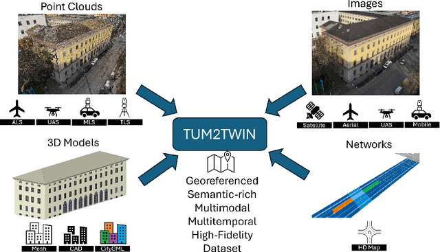

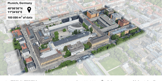
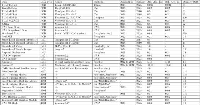
Abstract:Urban Digital Twins (UDTs) have become essential for managing cities and integrating complex, heterogeneous data from diverse sources. Creating UDTs involves challenges at multiple process stages, including acquiring accurate 3D source data, reconstructing high-fidelity 3D models, maintaining models' updates, and ensuring seamless interoperability to downstream tasks. Current datasets are usually limited to one part of the processing chain, hampering comprehensive UDTs validation. To address these challenges, we introduce the first comprehensive multimodal Urban Digital Twin benchmark dataset: TUM2TWIN. This dataset includes georeferenced, semantically aligned 3D models and networks along with various terrestrial, mobile, aerial, and satellite observations boasting 32 data subsets over roughly 100,000 $m^2$ and currently 767 GB of data. By ensuring georeferenced indoor-outdoor acquisition, high accuracy, and multimodal data integration, the benchmark supports robust analysis of sensors and the development of advanced reconstruction methods. Additionally, we explore downstream tasks demonstrating the potential of TUM2TWIN, including novel view synthesis of NeRF and Gaussian Splatting, solar potential analysis, point cloud semantic segmentation, and LoD3 building reconstruction. We are convinced this contribution lays a foundation for overcoming current limitations in UDT creation, fostering new research directions and practical solutions for smarter, data-driven urban environments. The project is available under: https://tum2t.win
Retrieval of sun-induced plant fluorescence in the O$_2$-A absorption band from DESIS imagery
Nov 12, 2024Abstract:We provide the first method allowing to retrieve spaceborne SIF maps at 30 m ground resolution with a strong correlation ($r^2=0.6$) to high-quality airborne estimates of sun-induced fluorescence (SIF). SIF estimates can provide explanatory information for many tasks related to agricultural management and physiological studies. While SIF products from airborne platforms are accurate and spatially well resolved, the data acquisition of such products remains science-oriented and limited to temporally constrained campaigns. Spaceborne SIF products on the other hand are available globally with often sufficient revisit times. However, the spatial resolution of spaceborne SIF products is too small for agricultural applications. In view of ESA's upcoming FLEX mission we develop a method for SIF retrieval in the O$_2$-A band of hyperspectral DESIS imagery to provide first insights for spaceborne SIF retrieval at high spatial resolution. To this end, we train a simulation-based self-supervised network with a novel perturbation based regularizer and test performance improvements under additional supervised regularization of atmospheric variable prediction. In a validation study with corresponding HyPlant derived SIF estimates at 740 nm we find that our model reaches a mean absolute difference of 0.78 mW / nm / sr / m$^2$.
Towards Large-scale Building Attribute Mapping using Crowdsourced Images: Scene Text Recognition on Flickr and Problems to be Solved
Sep 14, 2023
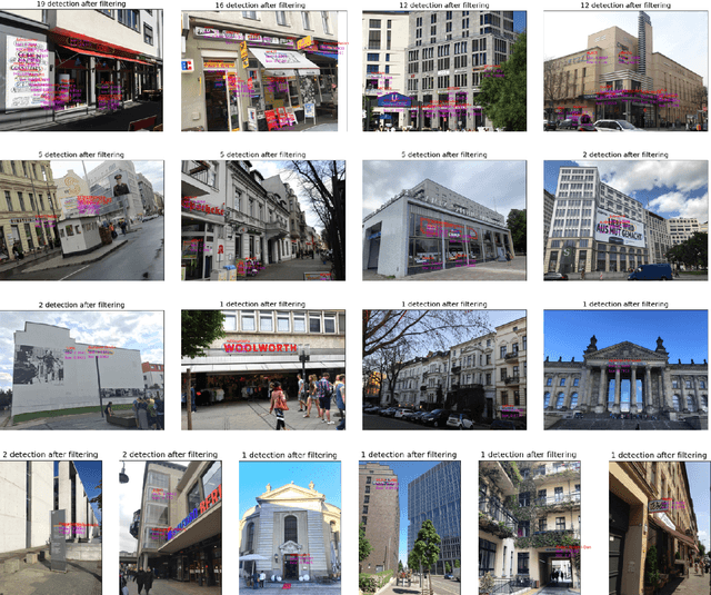
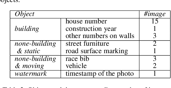

Abstract:Crowdsourced platforms provide huge amounts of street-view images that contain valuable building information. This work addresses the challenges in applying Scene Text Recognition (STR) in crowdsourced street-view images for building attribute mapping. We use Flickr images, particularly examining texts on building facades. A Berlin Flickr dataset is created, and pre-trained STR models are used for text detection and recognition. Manual checking on a subset of STR-recognized images demonstrates high accuracy. We examined the correlation between STR results and building functions, and analysed instances where texts were recognized on residential buildings but not on commercial ones. Further investigation revealed significant challenges associated with this task, including small text regions in street-view images, the absence of ground truth labels, and mismatches in buildings in Flickr images and building footprints in OpenStreetMap (OSM). To develop city-wide mapping beyond urban hotspot locations, we suggest differentiating the scenarios where STR proves effective while developing appropriate algorithms or bringing in additional data for handling other cases. Furthermore, interdisciplinary collaboration should be undertaken to understand the motivation behind building photography and labeling. The STR-on-Flickr results are publicly available at https://github.com/ya0-sun/STR-Berlin.
Drones4Good: Supporting Disaster Relief Through Remote Sensing and AI
Aug 09, 2023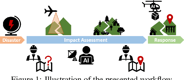


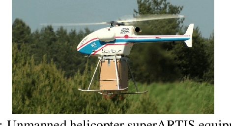
Abstract:In order to respond effectively in the aftermath of a disaster, emergency services and relief organizations rely on timely and accurate information about the affected areas. Remote sensing has the potential to significantly reduce the time and effort required to collect such information by enabling a rapid survey of large areas. To achieve this, the main challenge is the automatic extraction of relevant information from remotely sensed data. In this work, we show how the combination of drone-based data with deep learning methods enables automated and large-scale situation assessment. In addition, we demonstrate the integration of onboard image processing techniques for the deployment of autonomous drone-based aid delivery. The results show the feasibility of a rapid and large-scale image analysis in the field, and that onboard image processing can increase the safety of drone-based aid deliveries.
Generative Adversarial Networks for Synthesizing InSAR Patches
Aug 03, 2020


Abstract:Generative Adversarial Networks (GANs) have been employed with certain success for image translation tasks between optical and real-valued SAR intensity imagery. Applications include aiding interpretability of SAR scenes with their optical counterparts by artificial patch generation and automatic SAR-optical scene matching. The synthesis of artificial complex-valued InSAR image stacks asks for, besides good perceptual quality, more stringent quality metrics like phase noise and phase coherence. This paper provides a signal processing model of generative CNN structures, describes effects influencing those quality metrics and presents a mapping scheme of complex-valued data to given CNN structures based on popular Deep Learning frameworks.
 Add to Chrome
 Add to Firefox
 Add to Edge