Ozgur Ozdemir
Fusion of Cellular ISAC and Passive RF Sensing for UAV Detection and Tracking
Dec 16, 2025Abstract:The rapid growth of unmanned aerial vehicles (UAVs) in civilian and critical-infrastructure airspace has created a need for reliable detection and tracking systems that operate under diverse environmental and sensing conditions. This paper presents a UAV detection and tracking system that fuses measurements from a network of passive Keysight N6841A RF sensors and a Ku-band Fortem TrueView R20 radar operating in the FR3 spectrum (16.3 GHz) as an ISAC proxy. Real-world experiments at the NSF AERPAW testbed demonstrate that radar and RF sensing provide complementary strengths under varying geometric, range, and line-of-sight conditions. A Kalman filter using a constant-velocity motion model integrates the asynchronous 2D RF and 3D radar observations, suppressing large standalone errors, improving accuracy over individual modalities, and increasing tracking coverage without degrading performance. These results demonstrate the effectiveness of multi-modal, ISAC-oriented sensing for robust UAV tracking in outdoor environments.
Reliability of Wi-Fi, LTE, and 5G-Based UAV RC Links in ISM Bands: Uplink Interference Asymmetry Analysis and HARQ Design
Jul 27, 2025Abstract:Command and control of uncrewed aerial vehicles (UAVs) is often realized through air-to-ground (A2G) remote control (RC) links that operate in ISM bands. While wireless fidelity (Wi-Fi) technology is commonly used for UAV RC links, ISM-based long-term evolution (LTE) and fifth-generation (5G) technologies have also been recently considered for the same purpose. A major problem for UAV RC links in the ISM bands is that other types of interference sources, such as legacy Wi-Fi and Bluetooth transmissions, may degrade the link quality. Such interference problems are a higher concern for the UAV in the air than the RC unit on the ground due to the UAV being in line-of-sight (LoS) with a larger number of interference sources. To obtain empirical evidence of the asymmetric interference conditions in downlink (DL) and uplink (UL), we first conducted a measurement campaign using a helikite platform in urban and rural areas at NC State University. The results from this measurement campaign show that the aggregate interference can be up to 16.66 dB at higher altitudes up to 170 m, compared with the interference observed at a ground receiver. As a result of this asymmetric UL interference, lost hybrid automatic repeat request (HARQ) indicators (ACK/NACK) in the UL may degrade the DL throughput. To investigate this, we study various HARQ mechanisms, including HARQ Type-I with no combining, HARQ Type-I with chase combining, HARQ Type-III with incremental redundancy, and burst transmission with chase combining. To evaluate the impact of asymmetric UL interference on throughput performance, we consider three steps of evaluation process: 1) standalone physical DL shared channel (PDSCH) throughput evaluation with perfect ACK/NACK assumption; 2) standalone physical UL control channel (PUCCH) decoding reliability evaluation; and 3) PDSCH DL throughput evaluation with asymmetric UL ACK/NACK transmission.
Collection: Datasets from AFAR Challenge
May 11, 2025


Abstract:This paper presents a comprehensive real-world and Digital Twin (DT) dataset collected as part of the Find A Rover (AFAR) Challenge, organized by the NSF Aerial Experimentation and Research Platform for Advanced Wireless (AERPAW) testbed and hosted at the Lake Wheeler Field in Raleigh, North Carolina. The AFAR Challenge was a competition involving five finalist university teams, focused on promoting innovation in UAV-assisted radio frequency (RF) source localization. Participating teams were tasked with designing UAV flight trajectories and localization algorithms to detect the position of a hidden unmanned ground vehicle (UGV), also referred to as a rover, emitting wireless probe signals generated by GNU Radio. The competition was structured to evaluate solutions in a DT environment first, followed by deployment and testing in AERPAW's outdoor wireless testbed. For each team, the UGV was placed at three different positions, resulting in a total of 30 datasets, 15 collected in a DT simulation environment and 15 in a physical outdoor testbed. Each dataset contains time-synchronized measurements of received signal strength (RSS), received signal quality (RSQ), GPS coordinates, UAV velocity, and UAV orientation (roll, pitch, and yaw). Data is organized into structured folders by team, environment (DT and real-world), and UGV location. The dataset supports research in UAV-assisted RF source localization, air-to-ground (A2G) wireless propagation modeling, trajectory optimization, signal prediction, autonomous navigation, and DT validation. With approximately 300k time-synchronized samples collected from real-world experiments, the dataset provides a substantial foundation for training and evaluating deep learning (DL) models. Overall, the AFAR dataset serves as a valuable resource for advancing robust, real-world solutions in UAV-enabled wireless communications and sensing systems.
A UAV-assisted Wireless Localization Challenge on AERPAW
Jul 16, 2024


Abstract:As wireless researchers are tasked to enable wireless communication as infrastructure in more dynamic aerial settings, there is a growing need for large-scale experimental platforms that provide realistic, reproducible, and reliable experimental validation. To bridge the research-to-implementation gap, the Aerial Experimentation and Research Platform for Advanced Wireless (AERPAW) offers open-source tools, reference experiments, and hardware to facilitate and evaluate the development of wireless research in controlled digital twin environments and live testbed flights. The inaugural AERPAW Challenge, "Find a Rover," was issued to spark collaborative efforts and test the platform's capabilities. The task involved localizing a narrowband wireless signal, with teams given ten minutes to find the "rover" within a twenty-acre area. By engaging in this exercise, researchers can validate the platform's value as a tool for innovation in wireless communications research within aerial robotics. This paper recounts the methods and experiences of the top three teams in automating and rapidly locating a wireless signal by automating and controlling an aerial drone in a realistic testbed scenario.
A Survey on Detection, Classification, and Tracking of Aerial Threats using Radar and Communications Systems
Feb 08, 2024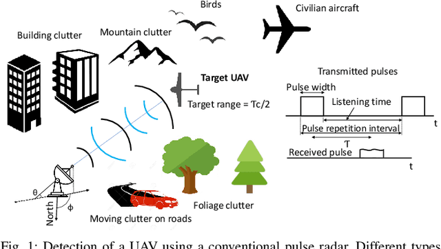
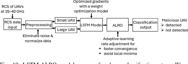
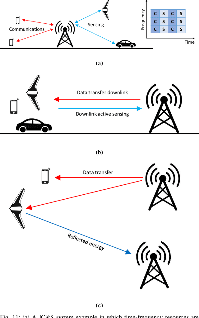
Abstract:The use of unmanned aerial vehicles (UAVs) for a variety of commercial, civilian, and defense applications has increased many folds in recent years. While UAVs are expected to transform future air operations, there are instances where they can be used for malicious purposes. In this context, the detection, classification, and tracking (DCT) of UAVs (DCT-U) for safety and surveillance of national air space is a challenging task when compared to DCT of manned aerial vehicles. In this survey, we discuss the threats and challenges from malicious UAVs and we subsequently study three radio frequency (RF)-based systems for DCT-U. These RF-based systems include radars, communication systems, and RF analyzers. Radar systems are further divided into conventional and modern radar systems, while communication systems can be used for joint communications and sensing (JC&S) in active mode and act as a source of illumination to passive radars for DCT-U. The limitations of the three RF-based systems are also provided. The survey briefly discusses non-RF systems for DCT-U and their limitations. Future directions based on the lessons learned are provided at the end of the survey.
Kriging-Based 3-D Spectrum Awareness for Radio Dynamic Zones Using Aerial Spectrum Sensors
Jul 12, 2023


Abstract:Radio dynamic zones (RDZs) are geographical areas within which dedicated spectrum resources are monitored and controlled to enable the development and testing of new spectrum technologies. Real-time spectrum awareness within an RDZ is critical for preventing interference with nearby incumbent users of the spectrum. In this paper, we consider a 3D RDZ scenario and propose to use unmanned aerial vehicles (UAVs) equipped with spectrum sensors to create and maintain a 3D radio map of received signal power from different sources within the RDZ. In particular, we introduce a 3D Kriging interpolation technique that uses realistic 3D correlation models of the signal power extracted from extensive measurements carried out at the NSF AERPAW platform. Using C-Band signal measurements by a UAV at altitudes between 30 m-110 m, we first develop realistic propagation models on air-to-ground path loss, shadowing, spatial correlation, and semi-variogram, while taking into account the knowledge of antenna radiation patterns and ground reflection. Subsequently, we generate a 3D radio map of a signal source within the RDZ using the Kriging interpolation and evaluate its sensitivity to the number of measurements used and their spatial distribution. Our results show that the proposed 3D Kriging interpolation technique provides significantly better radio maps when compared with an approach that assumes perfect knowledge of path loss.
Propagation Measurements and Coverage Analysis for mmWave and Sub-THz Frequency Bands with Transparent Reflectors
Jun 25, 2023Abstract:The emerging 5G and future 6G technologies are envisioned to provide higher bandwidths and coverage using millimeter wave (mmWave) and sub-Terahertz (THz) frequency bands. The growing demand for higher data rates using these bands can be addressed by overcoming high path loss, especially for non-line-of-sight (NLOS) scenarios. In this work, we investigate the use of passive transparent reflectors to improve signal coverage in an NLOS indoor scenario. Measurements are conducted to characterize the maximum reflectivity property of the transparent reflector using channel sounder equipment from NI. Flat and curved reflectors, each with a size of 16 inches by 16 inches, are used to study coverage improvements with different reflector shapes and orientations. The measurement results using passive metallic reflectors are also compared with the ray-tracing-based simulations, to further corroborate our inferences. The analysis reveals that the transparent reflector outperforms the metal reflector and increases the radio propagation coverage in all three frequencies of interest: 28~GHz, 39~GHz, and 120~GHz. Using transparent reflectors, there is an increase in peak received power that is greater than 5~dB for certain scenarios compared to metallic reflectors when used in flat mode, and greater than 3~dB when used in curved (convex) mode.
LTE I/Q Data Set for UAV Propagation Modeling, Communication, and Navigation Research
Mar 03, 2023Abstract:Recently, unmanned aerial vehicles (UAVs) have been receiving significant attention due to their wide range of potential application areas. To support UAV use cases with beyond visual line of sight (BVLOS) and autonomous flights, cellular networks can serve as ground connectivity points, and they can provide remote control and payload communication for UAV links. However, there are limited data sets to study the coverage of cellular technologies for UAV flights at different altitudes and develop machine learning (ML) techniques for improving UAV communication and navigation. In this article, we present raw LTE I/Q sample data sets from physical field experiments in the Lake Wheeler farm area of the NSF AERPAW experimentation platform. We fly a UAV that carries a software-defined radio (SDR) at altitudes ranging from 30~m to 110~m and collect raw I/Q samples from an SDR-based LTE base station on the ground operating at 3.51 GHz. We adopt a standard metadata format for reproducing the results from the collected data sets. The post-processing of raw I/Q samples using MATLAB's 4G LTE toolbox is described and various representative results are provided. In the end, we discuss the possible ways that our provided data set, post-processing sample code, and sample experiment code for collecting I/Q measurements and vehicle control can be used by other ML researchers in the future.
SDR-Based 5G NR C-Band I/Q Monitoring and Surveillance in Urban Area Using a Helikite
Mar 03, 2023Abstract:In this paper, we report experimental results in collectting and processing 5G NR I/Q samples in the 3.7~GHz C-band by using software-defined radio (SDR)-mounted helikite. We use MATLAB's 5G toolbox to post-process the collected data, to obtain the synchronization signal block (SSB) from the I/Q samples and then go through the cell search, synchronization procedures, and reference signal received power (RSRP) and reference signal received quality (RSRQ) calculation. We plot these performance metrics for various physical cell identities as a function of the helikite's altitude. Furthermore, building on our experience with the collected and post-processed data, we discuss potential vulnerabilities of 5G NR systems to surveillance, jamming attacks, and post quantum era attacks.
Spectrum Monitoring and Analysis in Urban and Rural Environments at Different Altitudes
Jan 06, 2023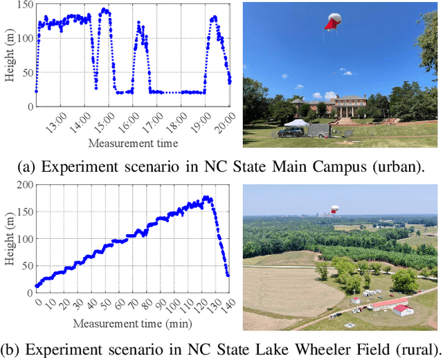
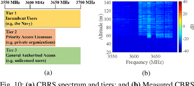
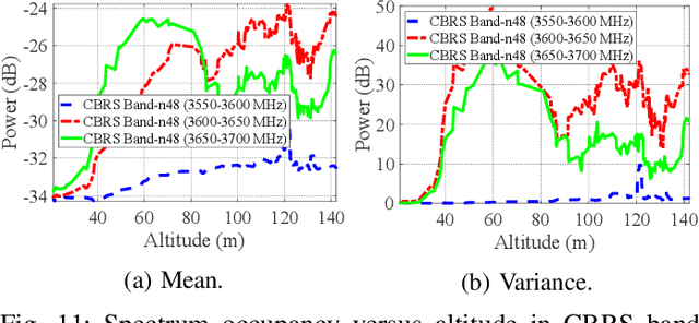
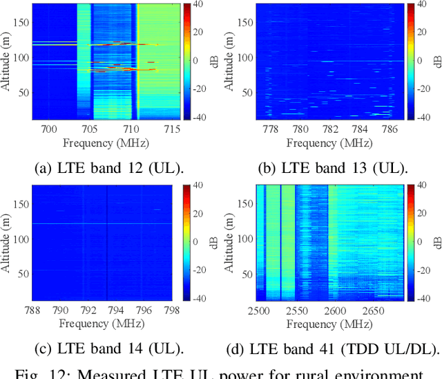
Abstract:Due to the scarcity of spectrum resources, the emergence of new technologies and ever-increasing number of wireless devices operating in the radio frequency spectrum lead to data congestion and interference. In this work, we study the effect of altitude on sub-6 GHz spectrum measurement results obtained at a Helikite flying over two distinct scenarios; i.e., urban and rural environments. Specifically, we aim at investigating the spectrum occupancy of various long-term evolution (LTE), $5^{\text{th}}$ generation (5G) and citizens broadband radio service (CBRS) bands utilized in the United States for both uplink and downlink at altitudes up to 180 meters. Our results reveal that generally the mean value of the measured power increases as the altitude increases where the line-of-sight links with nearby base stations is more available. SigMF-compliant spectrum measurement datasets used in this paper covering all the bands between 100~MHz to 6~GHz are also provided.
 Add to Chrome
 Add to Firefox
 Add to Edge