Ismail Guvenc
North Carolina State University
TransfoREM: Transformer aided 3D Radio Environment Mapping
Jan 23, 2026Abstract:Providing reliable cellular connectivity to Unmanned Aerial Vehicles (UAV) is a key challenge, as existing terrestrial networks are deployed mainly for ground-level coverage. The cellular network coverage may be available for a limited range from the antenna side lobes, with poor connectivity further exacerbated by UAV flight dynamics. In this work, we propose TransfoREM, a 3D Radio Environment Map (REM) generation method that combines deterministic channel models and real-world data to map terrestrial network coverage at higher altitudes. At the core of our solution is a transformer model that translates radio propagation mapping into a sequence prediction task to construct REMs. Our results demonstrate that TransfoREM offers improved interpolation capability on real-world data compared against conventional Kriging and other machine learning (ML) techniques. Furthermore, TransfoREM is designed for holistic integration into cellular networks at the base station (BS) level, where it can build REMs, which can then be leveraged for enhanced resource allocation, interference management, and spatial spectrum utilization.
Fusion of Cellular ISAC and Passive RF Sensing for UAV Detection and Tracking
Dec 16, 2025Abstract:The rapid growth of unmanned aerial vehicles (UAVs) in civilian and critical-infrastructure airspace has created a need for reliable detection and tracking systems that operate under diverse environmental and sensing conditions. This paper presents a UAV detection and tracking system that fuses measurements from a network of passive Keysight N6841A RF sensors and a Ku-band Fortem TrueView R20 radar operating in the FR3 spectrum (16.3 GHz) as an ISAC proxy. Real-world experiments at the NSF AERPAW testbed demonstrate that radar and RF sensing provide complementary strengths under varying geometric, range, and line-of-sight conditions. A Kalman filter using a constant-velocity motion model integrates the asynchronous 2D RF and 3D radar observations, suppressing large standalone errors, improving accuracy over individual modalities, and increasing tracking coverage without degrading performance. These results demonstrate the effectiveness of multi-modal, ISAC-oriented sensing for robust UAV tracking in outdoor environments.
Reliability of Wi-Fi, LTE, and 5G-Based UAV RC Links in ISM Bands: Uplink Interference Asymmetry Analysis and HARQ Design
Jul 27, 2025Abstract:Command and control of uncrewed aerial vehicles (UAVs) is often realized through air-to-ground (A2G) remote control (RC) links that operate in ISM bands. While wireless fidelity (Wi-Fi) technology is commonly used for UAV RC links, ISM-based long-term evolution (LTE) and fifth-generation (5G) technologies have also been recently considered for the same purpose. A major problem for UAV RC links in the ISM bands is that other types of interference sources, such as legacy Wi-Fi and Bluetooth transmissions, may degrade the link quality. Such interference problems are a higher concern for the UAV in the air than the RC unit on the ground due to the UAV being in line-of-sight (LoS) with a larger number of interference sources. To obtain empirical evidence of the asymmetric interference conditions in downlink (DL) and uplink (UL), we first conducted a measurement campaign using a helikite platform in urban and rural areas at NC State University. The results from this measurement campaign show that the aggregate interference can be up to 16.66 dB at higher altitudes up to 170 m, compared with the interference observed at a ground receiver. As a result of this asymmetric UL interference, lost hybrid automatic repeat request (HARQ) indicators (ACK/NACK) in the UL may degrade the DL throughput. To investigate this, we study various HARQ mechanisms, including HARQ Type-I with no combining, HARQ Type-I with chase combining, HARQ Type-III with incremental redundancy, and burst transmission with chase combining. To evaluate the impact of asymmetric UL interference on throughput performance, we consider three steps of evaluation process: 1) standalone physical DL shared channel (PDSCH) throughput evaluation with perfect ACK/NACK assumption; 2) standalone physical UL control channel (PUCCH) decoding reliability evaluation; and 3) PDSCH DL throughput evaluation with asymmetric UL ACK/NACK transmission.
Collection: Datasets from AFAR Challenge
May 11, 2025


Abstract:This paper presents a comprehensive real-world and Digital Twin (DT) dataset collected as part of the Find A Rover (AFAR) Challenge, organized by the NSF Aerial Experimentation and Research Platform for Advanced Wireless (AERPAW) testbed and hosted at the Lake Wheeler Field in Raleigh, North Carolina. The AFAR Challenge was a competition involving five finalist university teams, focused on promoting innovation in UAV-assisted radio frequency (RF) source localization. Participating teams were tasked with designing UAV flight trajectories and localization algorithms to detect the position of a hidden unmanned ground vehicle (UGV), also referred to as a rover, emitting wireless probe signals generated by GNU Radio. The competition was structured to evaluate solutions in a DT environment first, followed by deployment and testing in AERPAW's outdoor wireless testbed. For each team, the UGV was placed at three different positions, resulting in a total of 30 datasets, 15 collected in a DT simulation environment and 15 in a physical outdoor testbed. Each dataset contains time-synchronized measurements of received signal strength (RSS), received signal quality (RSQ), GPS coordinates, UAV velocity, and UAV orientation (roll, pitch, and yaw). Data is organized into structured folders by team, environment (DT and real-world), and UGV location. The dataset supports research in UAV-assisted RF source localization, air-to-ground (A2G) wireless propagation modeling, trajectory optimization, signal prediction, autonomous navigation, and DT validation. With approximately 300k time-synchronized samples collected from real-world experiments, the dataset provides a substantial foundation for training and evaluating deep learning (DL) models. Overall, the AFAR dataset serves as a valuable resource for advancing robust, real-world solutions in UAV-enabled wireless communications and sensing systems.
Predicting Lifespan of Ground-to-Air Multipath Components in mmWave UAV Channels
Mar 12, 2025Abstract:In mobile ground-to-air (GA) propagation channels, the birth and death of multipath components (MPCs) are frequently observed, and the wide-sense stationary uncorrelated scattering (WSSUS) assumption does not always hold. Several methods exist for tracking the birth and death of MPCs, however, to the best of knowledge of authors, there is no existing literature that addresses the prediction of the lifespan of the MPCs in nonWSSUS GA propagation channels. In this work, we consider the GA channel as non-WSSUS and individual MPCs across receiver positions are represented as time series based on the Euclidean distance between channel parameters of the MPCs. These time series representations, referred to as path bins, are analyzed using a semi-Markov chain model. The channel parameter variations and dependencies between path bins are used to predict the lifespan of path bins using weighted sum method, machine learning classifiers, and deep neural networks. For comparison, the birth and death of path bins are also modeled using a Poisson distribution and a Markov chain. Simulation results demonstrate that deep neural networks offer highly accurate predictions for the lifespan (including death) of MPC path bins in the considered GA propagation scenario.
* Accepted for Proc. IEEE WCNC Conference 2025, Italy
UAV-Assisted Coverage Hole Detection Using Reinforcement Learning in Urban Cellular Networks
Mar 09, 2025Abstract:Deployment of cellular networks in urban areas requires addressing various challenges. For example, high-rise buildings with varying geometrical shapes and heights contribute to signal attenuation, reflection, diffraction, and scattering effects. This creates a high possibility of coverage holes (CHs) within the proximity of the buildings. Detecting these CHs is critical for network operators to ensure quality of service, as customers in such areas experience weak or no signal reception. To address this challenge, we propose an approach using an autonomous vehicle, such as an unmanned aerial vehicle (UAV), to detect CHs, for minimizing drive test efforts and reducing human labor. The UAV leverages reinforcement learning (RL) to find CHs using stored local building maps, its current location, and measured signal strengths. As the UAV moves, it dynamically updates its knowledge of the signal environment and its direction to a nearby CH while avoiding collisions with buildings. We created a wide range of testing scenarios using building maps from OpenStreetMap and signal strength data generated by NVIDIA Sionna raytracing simulations. The results demonstrate that the RL-based approach performs better than non-machine learning, geometry-based methods in detecting CHs in urban areas. Additionally, even with a limited number of UAV measurements, the method achieves performance close to theoretical upper bounds that assume complete knowledge of all signal strengths.
Transforming Indoor Localization: Advanced Transformer Architecture for NLOS Dominated Wireless Environments with Distributed Sensors
Jan 14, 2025Abstract:Indoor localization in challenging non-line-of-sight (NLOS) environments often leads to mediocre accuracy with traditional approaches. Deep learning (DL) has been applied to tackle these challenges; however, many DL approaches overlook computational complexity, especially for floating-point operations (FLOPs), making them unsuitable for resource-limited devices. Transformer-based models have achieved remarkable success in natural language processing (NLP) and computer vision (CV) tasks, motivating their use in wireless applications. However, their use in indoor localization remains nascent, and directly applying Transformers for indoor localization can be both computationally intensive and exhibit limitations in accuracy. To address these challenges, in this work, we introduce a novel tokenization approach, referred to as Sensor Snapshot Tokenization (SST), which preserves variable-specific representations of power delay profile (PDP) and enhances attention mechanisms by effectively capturing multi-variate correlation. Complementing this, we propose a lightweight Swish-Gated Linear Unit-based Transformer (L-SwiGLU Transformer) model, designed to reduce computational complexity without compromising localization accuracy. Together, these contributions mitigate the computational burden and dependency on large datasets, making Transformer models more efficient and suitable for resource-constrained scenarios. The proposed tokenization method enables the Vanilla Transformer to achieve a 90th percentile positioning error of 0.388 m in a highly NLOS indoor factory, surpassing conventional tokenization methods. The L-SwiGLU ViT further reduces the error to 0.355 m, achieving an 8.51% improvement. Additionally, the proposed model outperforms a 14.1 times larger model with a 46.13% improvement, underscoring its computational efficiency.
Altitude-Dependent Cellular Spectrum Occupancy: from Measurements to Stochastic Geometry Models
Nov 09, 2024Abstract:The growing demand for aerial connectivity with unmanned aerial vehicles (UAVs) across diverse settings, ranging from urban to rural scenarios, requires developing a better understanding of spectrum occupancy at aerial corridors. In particular, understanding the altitude-dependent behavior of spectrum occupancy in cellular networks, which could be used in the future for enabling beyond visual line of sight (BVLOS) UAV connectivity, is critical. While there are existing models for characterizing altitude-dependent interference in the literature, they are not validated with data and need to be compared with real-world measurements. To address these gaps, in this paper, we conduct cellular spectrum occupancy measurements at various sub-6 GHz bands for altitudes up to 300 meters, in both urban and rural environments. To model the spectrum occupancy measurements, we introduce two different approaches: a theoretical model utilizing stochastic geometry with altitude-dependent factors (SOSGAD), and a ray-tracing model tailored to site-specific line of sight (LOS) and non-LOS scenarios. We analyze the asymptotic behavior of the SOSGAD model as the UAV altitude increases. Through comparative analysis, we assess the effectiveness of the SOSGAD and ray-tracing models for characterizing actual spectrum occupancy as a function of altitude. Our results show that the proposed SOSGAD model can be tuned to closely characterize the real-world spectrum occupancy behavior as the UAV altitude increases.
Energy-Efficient Sleep Mode Optimization of 5G mmWave Networks Using Deep Contextual MAB
May 15, 2024Abstract:Millimeter-wave (mmWave) networks, integral to 5G communication, offer a vast spectrum that addresses the issue of spectrum scarcity and enhances peak rate and capacity. However, their dense deployment, necessary to counteract propagation losses, leads to high power consumption. An effective strategy to reduce this energy consumption in mobile networks is the sleep mode optimization (SMO) of base stations (BSs). In this paper, we propose a novel SMO approach for mmWave BSs in a 3D urban environment. This approach, which incorporates a neural network (NN) based contextual multi-armed bandit (C-MAB) with an epsilon decay algorithm, accommodates the dynamic and diverse traffic of user equipment (UE) by clustering the UEs in their respective tracking areas (TAs). Our strategy includes beamforming, which helps reduce energy consumption from the UE side, while SMO minimizes energy use from the BS perspective. We extended our investigation to include Random, Epsilon Greedy, Upper Confidence Bound (UCB), and Load Based sleep mode (SM) strategies. We compared the performance of our proposed C-MAB based SM algorithm with those of All On and other alternative approaches. Simulation results show that our proposed method outperforms all other SM strategies in terms of the $10^{th}$ percentile of user rate and average throughput while demonstrating comparable average throughput to the All On approach. Importantly, it outperforms all approaches in terms of energy efficiency (EE).
A Survey on Detection, Classification, and Tracking of Aerial Threats using Radar and Communications Systems
Feb 08, 2024


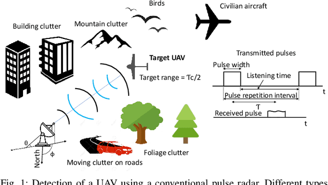
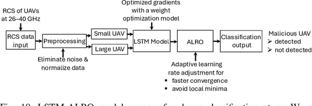
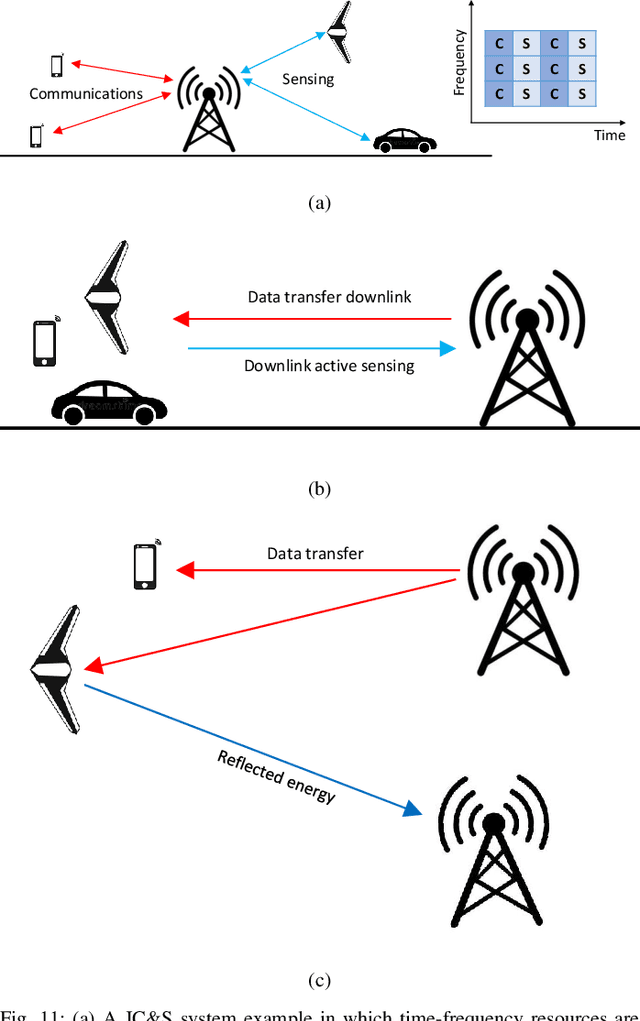
Abstract:The use of unmanned aerial vehicles (UAVs) for a variety of commercial, civilian, and defense applications has increased many folds in recent years. While UAVs are expected to transform future air operations, there are instances where they can be used for malicious purposes. In this context, the detection, classification, and tracking (DCT) of UAVs (DCT-U) for safety and surveillance of national air space is a challenging task when compared to DCT of manned aerial vehicles. In this survey, we discuss the threats and challenges from malicious UAVs and we subsequently study three radio frequency (RF)-based systems for DCT-U. These RF-based systems include radars, communication systems, and RF analyzers. Radar systems are further divided into conventional and modern radar systems, while communication systems can be used for joint communications and sensing (JC&S) in active mode and act as a source of illumination to passive radars for DCT-U. The limitations of the three RF-based systems are also provided. The survey briefly discusses non-RF systems for DCT-U and their limitations. Future directions based on the lessons learned are provided at the end of the survey.
 Add to Chrome
 Add to Firefox
 Add to Edge