Mihail L. Sichitiu
TransfoREM: Transformer aided 3D Radio Environment Mapping
Jan 23, 2026Abstract:Providing reliable cellular connectivity to Unmanned Aerial Vehicles (UAV) is a key challenge, as existing terrestrial networks are deployed mainly for ground-level coverage. The cellular network coverage may be available for a limited range from the antenna side lobes, with poor connectivity further exacerbated by UAV flight dynamics. In this work, we propose TransfoREM, a 3D Radio Environment Map (REM) generation method that combines deterministic channel models and real-world data to map terrestrial network coverage at higher altitudes. At the core of our solution is a transformer model that translates radio propagation mapping into a sequence prediction task to construct REMs. Our results demonstrate that TransfoREM offers improved interpolation capability on real-world data compared against conventional Kriging and other machine learning (ML) techniques. Furthermore, TransfoREM is designed for holistic integration into cellular networks at the base station (BS) level, where it can build REMs, which can then be leveraged for enhanced resource allocation, interference management, and spatial spectrum utilization.
Collection: Datasets from AFAR Challenge
May 11, 2025


Abstract:This paper presents a comprehensive real-world and Digital Twin (DT) dataset collected as part of the Find A Rover (AFAR) Challenge, organized by the NSF Aerial Experimentation and Research Platform for Advanced Wireless (AERPAW) testbed and hosted at the Lake Wheeler Field in Raleigh, North Carolina. The AFAR Challenge was a competition involving five finalist university teams, focused on promoting innovation in UAV-assisted radio frequency (RF) source localization. Participating teams were tasked with designing UAV flight trajectories and localization algorithms to detect the position of a hidden unmanned ground vehicle (UGV), also referred to as a rover, emitting wireless probe signals generated by GNU Radio. The competition was structured to evaluate solutions in a DT environment first, followed by deployment and testing in AERPAW's outdoor wireless testbed. For each team, the UGV was placed at three different positions, resulting in a total of 30 datasets, 15 collected in a DT simulation environment and 15 in a physical outdoor testbed. Each dataset contains time-synchronized measurements of received signal strength (RSS), received signal quality (RSQ), GPS coordinates, UAV velocity, and UAV orientation (roll, pitch, and yaw). Data is organized into structured folders by team, environment (DT and real-world), and UGV location. The dataset supports research in UAV-assisted RF source localization, air-to-ground (A2G) wireless propagation modeling, trajectory optimization, signal prediction, autonomous navigation, and DT validation. With approximately 300k time-synchronized samples collected from real-world experiments, the dataset provides a substantial foundation for training and evaluating deep learning (DL) models. Overall, the AFAR dataset serves as a valuable resource for advancing robust, real-world solutions in UAV-enabled wireless communications and sensing systems.
Digital Twins for Supporting AI Research with Autonomous Vehicle Networks
Apr 01, 2024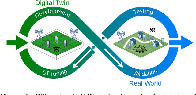
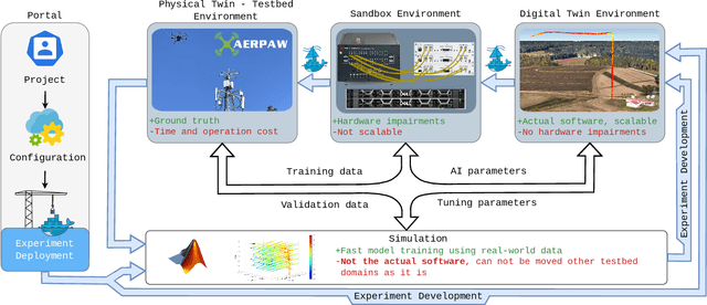
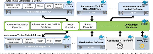
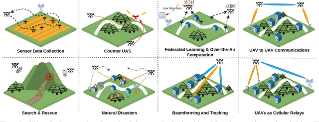
Abstract:Digital twins (DTs), which are virtual environments that simulate, predict, and optimize the performance of their physical counterparts, are envisioned to be essential technologies for advancing next-generation wireless networks. While DTs have been studied extensively for wireless networks, their use in conjunction with autonomous vehicles with programmable mobility remains relatively under-explored. In this paper, we study DTs used as a development environment to design, deploy, and test artificial intelligence (AI) techniques that use real-time observations, e.g. radio key performance indicators, for vehicle trajectory and network optimization decisions in an autonomous vehicle networks (AVN). We first compare and contrast the use of simulation, digital twin (software in the loop (SITL)), sandbox (hardware-in-the-loop (HITL)), and physical testbed environments for their suitability in developing and testing AI algorithms for AVNs. We then review various representative use cases of DTs for AVN scenarios. Finally, we provide an example from the NSF AERPAW platform where a DT is used to develop and test AI-aided solutions for autonomous unmanned aerial vehicles for localizing a signal source based solely on link quality measurements. Our results in the physical testbed show that SITL DTs, when supplemented with data from real-world (RW) measurements and simulations, can serve as an ideal environment for developing and testing innovative AI solutions for AVNs.
Kriging-Based 3-D Spectrum Awareness for Radio Dynamic Zones Using Aerial Spectrum Sensors
Jul 12, 2023


Abstract:Radio dynamic zones (RDZs) are geographical areas within which dedicated spectrum resources are monitored and controlled to enable the development and testing of new spectrum technologies. Real-time spectrum awareness within an RDZ is critical for preventing interference with nearby incumbent users of the spectrum. In this paper, we consider a 3D RDZ scenario and propose to use unmanned aerial vehicles (UAVs) equipped with spectrum sensors to create and maintain a 3D radio map of received signal power from different sources within the RDZ. In particular, we introduce a 3D Kriging interpolation technique that uses realistic 3D correlation models of the signal power extracted from extensive measurements carried out at the NSF AERPAW platform. Using C-Band signal measurements by a UAV at altitudes between 30 m-110 m, we first develop realistic propagation models on air-to-ground path loss, shadowing, spatial correlation, and semi-variogram, while taking into account the knowledge of antenna radiation patterns and ground reflection. Subsequently, we generate a 3D radio map of a signal source within the RDZ using the Kriging interpolation and evaluate its sensitivity to the number of measurements used and their spatial distribution. Our results show that the proposed 3D Kriging interpolation technique provides significantly better radio maps when compared with an approach that assumes perfect knowledge of path loss.
SDR-Based 5G NR C-Band I/Q Monitoring and Surveillance in Urban Area Using a Helikite
Mar 03, 2023Abstract:In this paper, we report experimental results in collectting and processing 5G NR I/Q samples in the 3.7~GHz C-band by using software-defined radio (SDR)-mounted helikite. We use MATLAB's 5G toolbox to post-process the collected data, to obtain the synchronization signal block (SSB) from the I/Q samples and then go through the cell search, synchronization procedures, and reference signal received power (RSRP) and reference signal received quality (RSRQ) calculation. We plot these performance metrics for various physical cell identities as a function of the helikite's altitude. Furthermore, building on our experience with the collected and post-processed data, we discuss potential vulnerabilities of 5G NR systems to surveillance, jamming attacks, and post quantum era attacks.
LTE I/Q Data Set for UAV Propagation Modeling, Communication, and Navigation Research
Mar 03, 2023Abstract:Recently, unmanned aerial vehicles (UAVs) have been receiving significant attention due to their wide range of potential application areas. To support UAV use cases with beyond visual line of sight (BVLOS) and autonomous flights, cellular networks can serve as ground connectivity points, and they can provide remote control and payload communication for UAV links. However, there are limited data sets to study the coverage of cellular technologies for UAV flights at different altitudes and develop machine learning (ML) techniques for improving UAV communication and navigation. In this article, we present raw LTE I/Q sample data sets from physical field experiments in the Lake Wheeler farm area of the NSF AERPAW experimentation platform. We fly a UAV that carries a software-defined radio (SDR) at altitudes ranging from 30~m to 110~m and collect raw I/Q samples from an SDR-based LTE base station on the ground operating at 3.51 GHz. We adopt a standard metadata format for reproducing the results from the collected data sets. The post-processing of raw I/Q samples using MATLAB's 4G LTE toolbox is described and various representative results are provided. In the end, we discuss the possible ways that our provided data set, post-processing sample code, and sample experiment code for collecting I/Q measurements and vehicle control can be used by other ML researchers in the future.
A Millimeter-Wave Software-Defined Radio for Wireless Experimentation
Feb 16, 2023
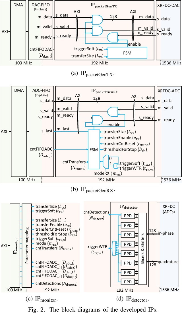
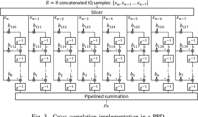
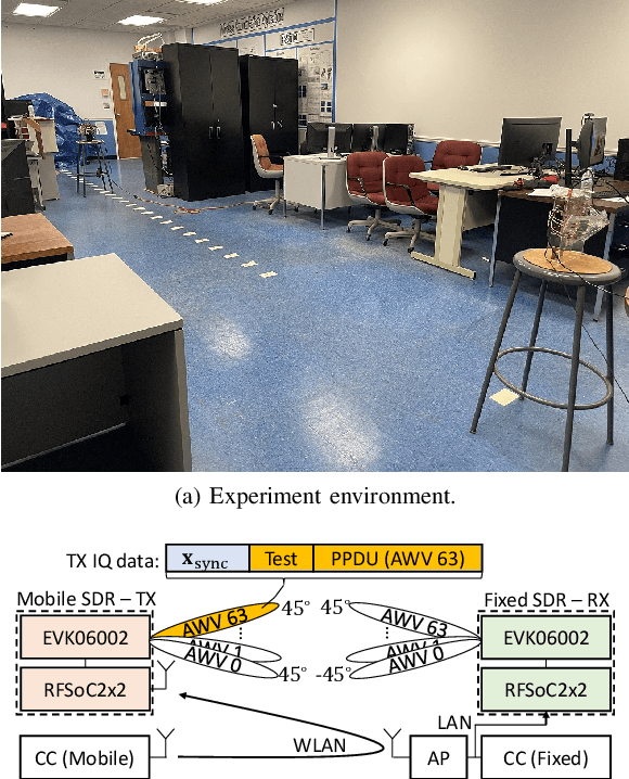
Abstract:In this study, we propose a low-cost and portable millimeter-wave software-defined radio (SDR) for wireless experimentation in the 60 GHz band. The proposed SDR uses Xilinx RFSoC2x2 and Sivers EVK06002 homodyne transceiver and provides a TCP/IP-based interface for companion computer (CC)-based baseband signal processing. To address the large difference between the processing speed of the CC and the sample rate of analog-to-digital converters, we propose a method, called waveform-triggered reception (WTR), where a hard-coded block detects a special trigger waveform to acquire a pre-determined number of IQ samples upon the detection. We also introduce a buffer mechanism to support discontinuous transmissions. By utilizing the WTR along with discontinuous transmissions, we conduct a beam sweeping experiment, where we evaluate 4096 beam pairs rapidly without compromising the flexibility of the CC-based processing. We also generate a dataset that allows one to calculate physical layer parameters such as signal-to-noise ratio and channel frequency response for a given pair of transmit and receive beam indices.
Distributed Robust Geocast Multicast Routing for Inter-Vehicle Communication
Mar 31, 2022


Abstract:Numerous protocols for geocast have been proposed in literature. It has been shown that explicit route setup approaches perform poorly with VANETs due to limited route lifetime and frequent network fragmentation. The broadcast based approaches have considerable redundancy and add significantly to the overhead of the protocol. A completely distributed and robust geocast approach is presented in this paper, that is resilient to frequent topology changes and network fragmentation. A distance-based backoff algorithm is used to reduce the number of hops and a novel mechanism to reduce redundant broadcasts is introduced. The performance of the proposed protocol is evaluated for various scenarios and compared with simple flooding and a protocol based on explicit route setup.
* 12 pages
Out-of-Zone Signal Leakage Sensing in Radio Dynamic Zones
Nov 18, 2021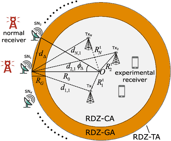

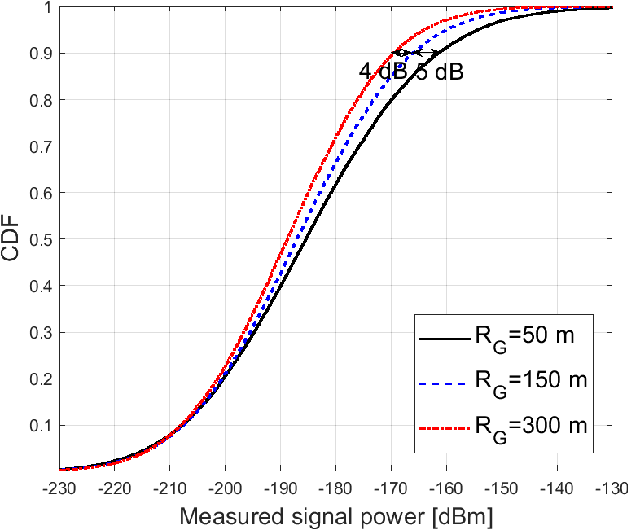
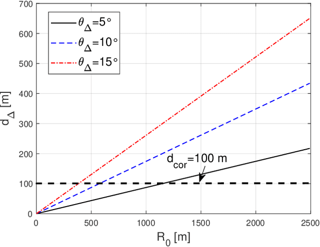
Abstract:Radio dynamic zones (RDZs) are geographically bounded areas where novel advanced wireless technologies can be developed, tested, and improved, without the concern of interfering to other incumbent radio technologies nearby the RDZ. In order to operate an RDZ, use of a real-time spectrum monitoring system carries critical importance. Such a monitoring system should detect out-of-zone (OoZ) signal leakage outside of the RDZ, and if the interference to nearby receivers is intolerable, the monitoring system should be capable of mitigating such interference. This can e.g. be achieved by stopping operations inside the RDZ or switching to other bands for RDZ operation. In this paper, we introduce a spectrum monitoring concept for OoZ signal leakage detection at RDZs, where sensor nodes (SNs) are installed at the boundary of an RDZ and monitor the power leakage from multiple transmitters within the RDZ. We propose a prediction algorithm that estimates the received interference at OoZ geographical locations outside of the RDZ, using the measurements obtained at sparsely located SNs at the RDZ boundary. Using computer simulations, we evaluate the performance of the proposed algorithm and study its sensitivity to SN deployment density.
Experimental Study of Outdoor UAV Localization and Tracking using Passive RF Sensing
Sep 03, 2021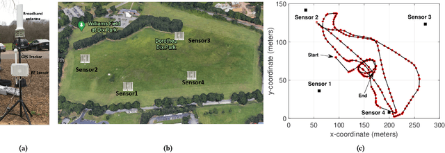

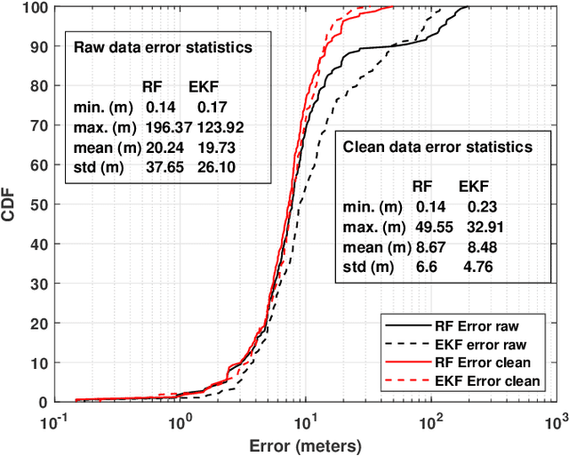

Abstract:Extensive use of unmanned aerial vehicles (UAVs) is expected to raise privacy and security concerns among individuals and communities. In this context, the detection and localization of UAVs will be critical for maintaining safe and secure airspace in the future. In this work, Keysight N6854A radio frequency (RF) sensors are used to detect and locate a UAV by passively monitoring the signals emitted from the UAV. First, the Keysight sensor detects the UAV by comparing the received RF signature with various other UAVs' RF signatures in the Keysight database using an envelope detection algorithm. Afterward, time difference of arrival (TDoA) based localization is performed by a central controller using the sensor data, and the drone is localized with some error. To mitigate the localization error, implementation of an extended Kalman filter~(EKF) is proposed in this study. The performance of the proposed approach is evaluated on a realistic experimental dataset. EKF requires basic assumptions on the type of motion throughout the trajectory, i.e., the movement of the object is assumed to fit some motion model~(MM) such as constant velocity (CV), constant acceleration (CA), and constant turn (CT). In the experiments, an arbitrary trajectory is followed, therefore it is not feasible to fit the whole trajectory into a single MM. Consequently, the trajectory is segmented into sub-parts and a different MM is assumed in each segment while building the EKF model. Simulation results demonstrate an improvement in error statistics when EKF is used if the MM assumption aligns with the real motion.
 Add to Chrome
 Add to Firefox
 Add to Edge