Mohamad Qadri
Acoustic Neural 3D Reconstruction Under Pose Drift
Mar 11, 2025Abstract:We consider the problem of optimizing neural implicit surfaces for 3D reconstruction using acoustic images collected with drifting sensor poses. The accuracy of current state-of-the-art 3D acoustic modeling algorithms is highly dependent on accurate pose estimation; small errors in sensor pose can lead to severe reconstruction artifacts. In this paper, we propose an algorithm that jointly optimizes the neural scene representation and sonar poses. Our algorithm does so by parameterizing the 6DoF poses as learnable parameters and backpropagating gradients through the neural renderer and implicit representation. We validated our algorithm on both real and simulated datasets. It produces high-fidelity 3D reconstructions even under significant pose drift.
Your Learned Constraint is Secretly a Backward Reachable Tube
Jan 26, 2025Abstract:Inverse Constraint Learning (ICL) is the problem of inferring constraints from safe (i.e., constraint-satisfying) demonstrations. The hope is that these inferred constraints can then be used downstream to search for safe policies for new tasks and, potentially, under different dynamics. Our paper explores the question of what mathematical entity ICL recovers. Somewhat surprisingly, we show that both in theory and in practice, ICL recovers the set of states where failure is inevitable, rather than the set of states where failure has already happened. In the language of safe control, this means we recover a backwards reachable tube (BRT) rather than a failure set. In contrast to the failure set, the BRT depends on the dynamics of the data collection system. We discuss the implications of the dynamics-conditionedness of the recovered constraint on both the sample-efficiency of policy search and the transferability of learned constraints.
Z-Splat: Z-Axis Gaussian Splatting for Camera-Sonar Fusion
Apr 06, 2024


Abstract:Differentiable 3D-Gaussian splatting (GS) is emerging as a prominent technique in computer vision and graphics for reconstructing 3D scenes. GS represents a scene as a set of 3D Gaussians with varying opacities and employs a computationally efficient splatting operation along with analytical derivatives to compute the 3D Gaussian parameters given scene images captured from various viewpoints. Unfortunately, capturing surround view ($360^{\circ}$ viewpoint) images is impossible or impractical in many real-world imaging scenarios, including underwater imaging, rooms inside a building, and autonomous navigation. In these restricted baseline imaging scenarios, the GS algorithm suffers from a well-known 'missing cone' problem, which results in poor reconstruction along the depth axis. In this manuscript, we demonstrate that using transient data (from sonars) allows us to address the missing cone problem by sampling high-frequency data along the depth axis. We extend the Gaussian splatting algorithms for two commonly used sonars and propose fusion algorithms that simultaneously utilize RGB camera data and sonar data. Through simulations, emulations, and hardware experiments across various imaging scenarios, we show that the proposed fusion algorithms lead to significantly better novel view synthesis (5 dB improvement in PSNR) and 3D geometry reconstruction (60% lower Chamfer distance).
AONeuS: A Neural Rendering Framework for Acoustic-Optical Sensor Fusion
Feb 05, 2024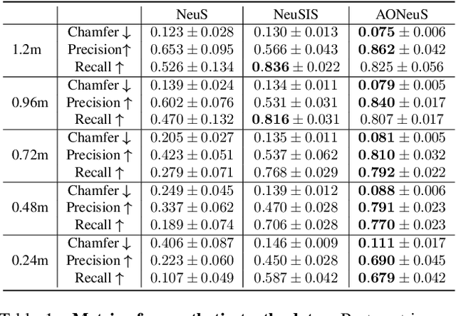

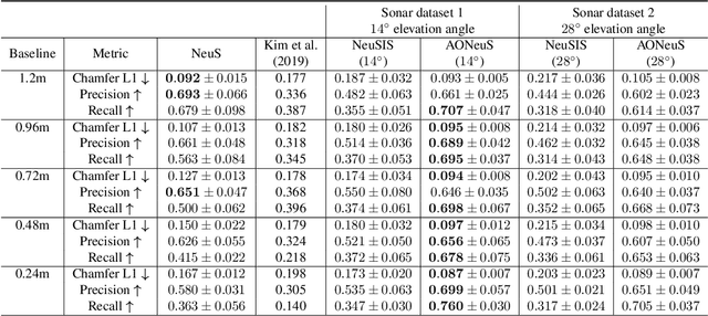

Abstract:Underwater perception and 3D surface reconstruction are challenging problems with broad applications in construction, security, marine archaeology, and environmental monitoring. Treacherous operating conditions, fragile surroundings, and limited navigation control often dictate that submersibles restrict their range of motion and, thus, the baseline over which they can capture measurements. In the context of 3D scene reconstruction, it is well-known that smaller baselines make reconstruction more challenging. Our work develops a physics-based multimodal acoustic-optical neural surface reconstruction framework (AONeuS) capable of effectively integrating high-resolution RGB measurements with low-resolution depth-resolved imaging sonar measurements. By fusing these complementary modalities, our framework can reconstruct accurate high-resolution 3D surfaces from measurements captured over heavily-restricted baselines. Through extensive simulations and in-lab experiments, we demonstrate that AONeuS dramatically outperforms recent RGB-only and sonar-only inverse-differentiable-rendering--based surface reconstruction methods. A website visualizing the results of our paper is located at this address: https://aoneus.github.io/
Toward Semantic Scene Understanding for Fine-Grained 3D Modeling of Plants
Dec 28, 2023Abstract:Agricultural robotics is an active research area due to global population growth and expectations of food and labor shortages. Robots can potentially help with tasks such as pruning, harvesting, phenotyping, and plant modeling. However, agricultural automation is hampered by the difficulty in creating high resolution 3D semantic maps in the field that would allow for safe manipulation and navigation. In this paper, we build toward solutions for this issue and showcase how the use of semantics and environmental priors can help in constructing accurate 3D maps for the target application of sorghum. Specifically, we 1) use sorghum seeds as semantic landmarks to build a visual Simultaneous Localization and Mapping (SLAM) system that enables us to map 78\\% of a sorghum range on average, compared to 38% with ORB-SLAM2; and 2) use seeds as semantic features to improve 3D reconstruction of a full sorghum panicle from images taken by a robotic in-hand camera.
Learning Covariances for Estimation with Constrained Bilevel Optimization
Sep 18, 2023Abstract:We consider the problem of learning error covariance matrices for robotic state estimation. The convergence of a state estimator to the correct belief over the robot state is dependent on the proper tuning of noise models. During inference, these models are used to weigh different blocks of the Jacobian and error vector resulting from linearization and hence, additionally affect the stability and convergence of the non-linear system. We propose a gradient-based method to estimate well-conditioned covariance matrices by formulating the learning process as a constrained bilevel optimization problem over factor graphs. We evaluate our method against baselines across a range of simulated and real-world tasks and demonstrate that our technique converges to model estimates that lead to better solutions as evidenced by the improved tracking accuracy on unseen test trajectories.
Learning Observation Models with Incremental Non-Differentiable Graph Optimizers in the Loop for Robotics State Estimation
Sep 05, 2023Abstract:We consider the problem of learning observation models for robot state estimation with incremental non-differentiable optimizers in the loop. Convergence to the correct belief over the robot state is heavily dependent on a proper tuning of observation models which serve as input to the optimizer. We propose a gradient-based learning method which converges much quicker to model estimates that lead to solutions of much better quality compared to an existing state-of-the-art method as measured by the tracking accuracy over unseen robot test trajectories.
Autonomous Apple Fruitlet Sizing and Growth Rate Tracking using Computer Vision
Dec 03, 2022Abstract:Measuring growth rates of apple fruitlets is important because it allows apple growers to determine when to apply chemical thinners to their crops to optimize yield. The current practice of obtaining growth rates involves using calipers to record sizes of fruitlets across multiple days. Due to the number of fruitlets needed to be sized, this method is laborious, time-consuming, and prone to human error. In this paper, we present a computer vision approach to measure the sizes and growth rates of apple fruitlets. With images collected by a hand-held stereo camera, our system detects, segments, and fits ellipses to fruitlets to measure their diameters. To measure growth rates, we utilize an Attentional Graph Neural Network to associate fruitlets across different days. We provide quantitative results on data collected in an apple orchard, and demonstrate that our system is able to predict abscise rates within 3% of the current method with a 7 times improvement in speed, while requiring significantly less manual effort. Moreover, we provide results on images captured by a robotic system in the field, and discuss the next steps to make the process fully autonomous.
Conditional GANs for Sonar Image Filtering with Applications to Underwater Occupancy Mapping
Sep 23, 2022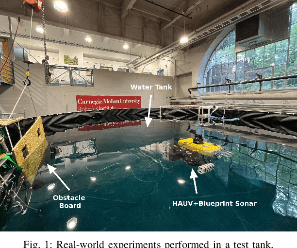
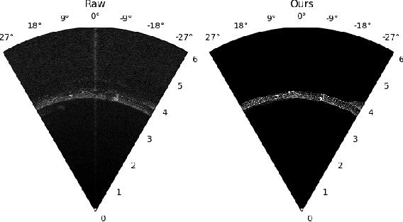
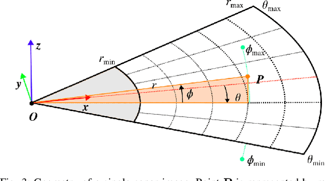
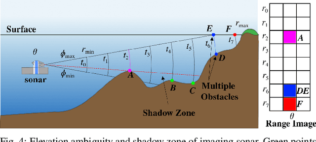
Abstract:Underwater robots typically rely on acoustic sensors like sonar to perceive their surroundings. However, these sensors are often inundated with multiple sources and types of noise, which makes using raw data for any meaningful inference with features, objects, or boundary returns very difficult. While several conventional methods of dealing with noise exist, their success rates are unsatisfactory. This paper presents a novel application of conditional Generative Adversarial Networks (cGANs) to train a model to produce noise-free sonar images, outperforming several conventional filtering methods. Estimating free space is crucial for autonomous robots performing active exploration and mapping. Thus, we apply our approach to the task of underwater occupancy mapping and show superior free and occupied space inference when compared to conventional methods.
Neural Implicit Surface Reconstruction using Imaging Sonar
Sep 17, 2022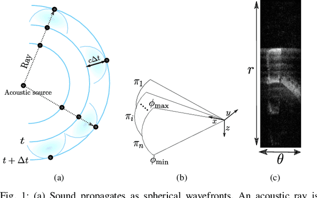
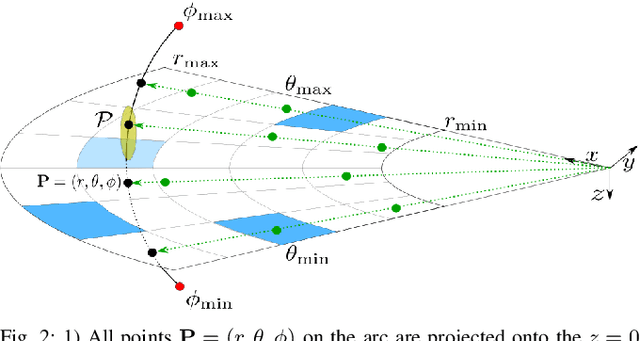
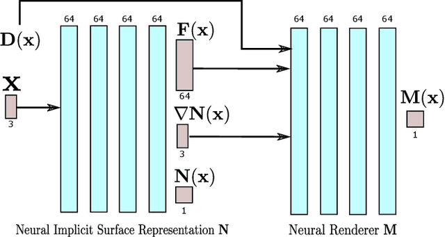
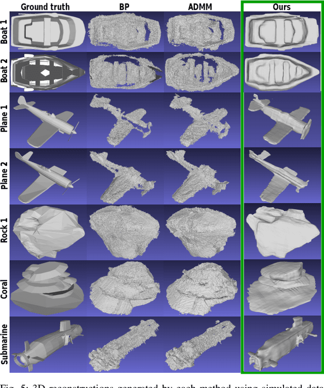
Abstract:We present a technique for dense 3D reconstruction of objects using an imaging sonar, also known as forward-looking sonar (FLS). Compared to previous methods that model the scene geometry as point clouds or volumetric grids, we represent the geometry as a neural implicit function. Additionally, given such a representation, we use a differentiable volumetric renderer that models the propagation of acoustic waves to synthesize imaging sonar measurements. We perform experiments on real and synthetic datasets and show that our algorithm reconstructs high-fidelity surface geometry from multi-view FLS images at much higher quality than was possible with previous techniques and without suffering from their associated memory overhead.
 Add to Chrome
 Add to Firefox
 Add to Edge