Hengwei Zhao
HOpenCls: Training Hyperspectral Image Open-Set Classifiers in Their Living Environments
Feb 21, 2025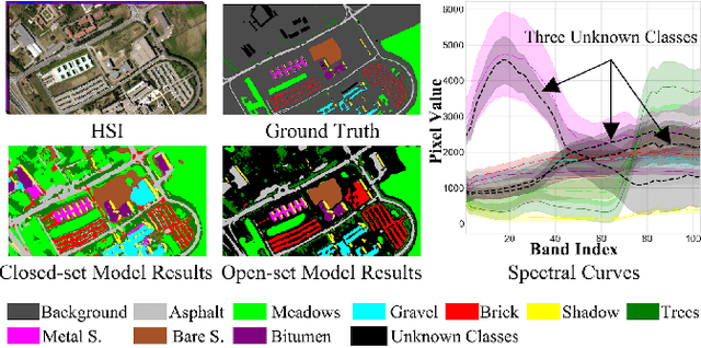
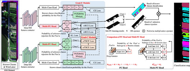
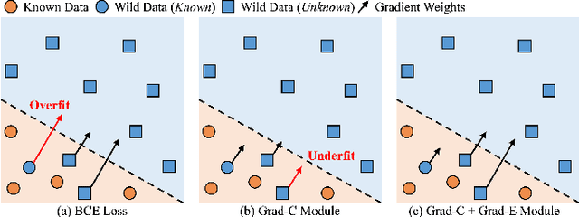

Abstract:Hyperspectral image (HSI) open-set classification is critical for HSI classification models deployed in real-world environments, where classifiers must simultaneously classify known classes and reject unknown classes. Recent methods utilize auxiliary unknown classes data to improve classification performance. However, the auxiliary unknown classes data is strongly assumed to be completely separable from known classes and requires labor-intensive annotation. To address this limitation, this paper proposes a novel framework, HOpenCls, to leverage the unlabeled wild data-that is the mixture of known and unknown classes. Such wild data is abundant and can be collected freely during deploying classifiers in their living environments. The key insight is reformulating the open-set HSI classification with unlabeled wild data as a positive-unlabeled (PU) learning problem. Specifically, the multi-label strategy is introduced to bridge the PU learning and open-set HSI classification, and then the proposed gradient contraction and gradient expansion module to make this PU learning problem tractable from the observation of abnormal gradient weights associated with wild data. Extensive experiment results demonstrate that incorporating wild data has the potential to significantly enhance open-set HSI classification in complex real-world scenarios.
AnomalyCD: A benchmark for Earth anomaly change detection with high-resolution and time-series observations
Sep 09, 2024


Abstract:Various Earth anomalies have destroyed the stable, balanced state, resulting in fatalities and serious destruction of property. With the advantages of large-scale and precise observation, high-resolution remote sensing images have been widely used for anomaly monitoring and localization. Powered by the deep representation, the existing methods have achieved remarkable advances, primarily in classification and change detection techniques. However, labeled samples are difficult to acquire due to the low probability of anomaly occurrence, and the trained models are limited to fixed anomaly categories, which hinders the application for anomalies with few samples or unknown anomalies. In this paper, to tackle this problem, we propose the anomaly change detection (AnomalyCD) technique, which accepts time-series observations and learns to identify anomalous changes by learning from the historical normal change pattern. Compared to the existing techniques, AnomalyCD processes an unfixed number of time steps and can localize the various anomalies in a unified manner, without human supervision. To benchmark AnomalyCD, we constructed a high-resolution dataset with time-series images dedicated to various Earth anomalies (the AnomalyCDD dataset). AnomalyCDD contains high-resolution (from 0.15 to 2.39 m/pixel), time-series (from 3 to 7 time steps), and large-scale images (1927.93 km2 in total) collected globally Furthermore, we developed a zero-shot baseline model (AnomalyCDM), which implements the AnomalyCD technique by extracting a general representation from the segment anything model (SAM) and conducting temporal comparison to distinguish the anomalous changes from normal changes. AnomalyCDM is designed as a two-stage workflow to enhance the efficiency, and has the ability to process the unseen images directly, without retraining for each scene.
A Unified Remote Sensing Anomaly Detector Across Modalities and Scenes via Deviation Relationship Learning
Oct 11, 2023


Abstract:Remote sensing anomaly detector can find the objects deviating from the background as potential targets. Given the diversity in earth anomaly types, a unified anomaly detector across modalities and scenes should be cost-effective and flexible to new earth observation sources and anomaly types. However, the current anomaly detectors are limited to a single modality and single scene, since they aim to learn the varying background distribution. Motivated by the universal anomaly deviation pattern, in that anomalies exhibit deviations from their local context, we exploit this characteristic to build a unified anomaly detector. Firstly, we reformulate the anomaly detection task as an undirected bilayer graph based on the deviation relationship, where the anomaly score is modeled as the conditional probability, given the pattern of the background and normal objects. The learning objective is then expressed as a conditional probability ranking problem. Furthermore, we design an instantiation of the reformulation in the data, architecture, and optimization aspects. Simulated spectral and spatial anomalies drive the instantiated architecture. The model is optimized directly for the conditional probability ranking. The proposed model was validated in five modalities including the hyperspectral, visible light, synthetic aperture radar (SAR), infrared and low light to show its unified detection ability.
Class Prior-Free Positive-Unlabeled Learning with Taylor Variational Loss for Hyperspectral Remote Sensing Imagery
Aug 29, 2023


Abstract:Positive-unlabeled learning (PU learning) in hyperspectral remote sensing imagery (HSI) is aimed at learning a binary classifier from positive and unlabeled data, which has broad prospects in various earth vision applications. However, when PU learning meets limited labeled HSI, the unlabeled data may dominate the optimization process, which makes the neural networks overfit the unlabeled data. In this paper, a Taylor variational loss is proposed for HSI PU learning, which reduces the weight of the gradient of the unlabeled data by Taylor series expansion to enable the network to find a balance between overfitting and underfitting. In addition, the self-calibrated optimization strategy is designed to stabilize the training process. Experiments on 7 benchmark datasets (21 tasks in total) validate the effectiveness of the proposed method. Code is at: https://github.com/Hengwei-Zhao96/T-HOneCls.
One-Step Detection Paradigm for Hyperspectral Anomaly Detection via Spectral Deviation Relationship Learning
Mar 22, 2023


Abstract:Hyperspectral anomaly detection (HAD) involves identifying the targets that deviate spectrally from their surroundings, without prior knowledge. Recently, deep learning based methods have become the mainstream HAD methods, due to their powerful spatial-spectral feature extraction ability. However, the current deep detection models are optimized to complete a proxy task (two-step paradigm), such as background reconstruction or generation, rather than achieving anomaly detection directly. This leads to suboptimal results and poor transferability, which means that the deep model is trained and tested on the same image. In this paper, an unsupervised transferred direct detection (TDD) model is proposed, which is optimized directly for the anomaly detection task (one-step paradigm) and has transferability. Specially, the TDD model is optimized to identify the spectral deviation relationship according to the anomaly definition. Compared to learning the specific background distribution as most models do, the spectral deviation relationship is universal for different images and guarantees the model transferability. To train the TDD model in an unsupervised manner, an anomaly sample simulation strategy is proposed to generate numerous pairs of anomaly samples. Furthermore, a global self-attention module and a local self-attention module are designed to help the model focus on the "spectrally deviating" relationship. The TDD model was validated on four public HAD datasets. The results show that the proposed TDD model can successfully overcome the limitation of traditional model training and testing on a single image, and the model has a powerful detection ability and excellent transferability.
Anomaly Segmentation for High-Resolution Remote Sensing Images Based on Pixel Descriptors
Jan 31, 2023


Abstract:Anomaly segmentation in high spatial resolution (HSR) remote sensing imagery is aimed at segmenting anomaly patterns of the earth deviating from normal patterns, which plays an important role in various Earth vision applications. However, it is a challenging task due to the complex distribution and the irregular shapes of objects, and the lack of abnormal samples. To tackle these problems, an anomaly segmentation model based on pixel descriptors (ASD) is proposed for anomaly segmentation in HSR imagery. Specifically, deep one-class classification is introduced for anomaly segmentation in the feature space with discriminative pixel descriptors. The ASD model incorporates the data argument for generating virtual ab-normal samples, which can force the pixel descriptors to be compact for normal data and meanwhile to be diverse to avoid the model collapse problems when only positive samples participated in the training. In addition, the ASD introduced a multi-level and multi-scale feature extraction strategy for learning the low-level and semantic information to make the pixel descriptors feature-rich. The proposed ASD model was validated using four HSR datasets and compared with the recent state-of-the-art models, showing its potential value in Earth vision applications.
Learning One-Class Hyperspectral Classifier from Positive and Unlabeled Data for Low Proportion Target
Oct 27, 2022


Abstract:Hyperspectral imagery (HSI) one-class classification is aimed at identifying a single target class from the HSI by using only positive labels, which can significantly reduce the requirements for annotation. However, HSI one-class classification is far more challenging than HSI multi-class classification, due the lack of negative labels and the low target proportion, which are issues that have rarely been considered in the previous HSI classification studies. In this paper, a weakly supervised HSI one-class classifier, namely HOneCls is proposed to solve the problem of under-fitting of the positive class occurs in the HSI data with low target proportion, where a risk estimator -- the One-Class Risk Estimator -- is particularly introduced to make the full convolutional neural network (FCN) with the ability of one class classification. The experimental results obtained on challenging hyperspectral classification datasets, which includes 20 kinds of ground objects with very similar spectra, demonstrate the efficiency and feasibility of the proposed One-Class Risk Estimator. Compared with the state-of-the-art one-class classifiers, the F1-score is improved significantly in the HSI data with low target proportion.
The Outcome of the 2022 Landslide4Sense Competition: Advanced Landslide Detection from Multi-Source Satellite Imagery
Sep 12, 2022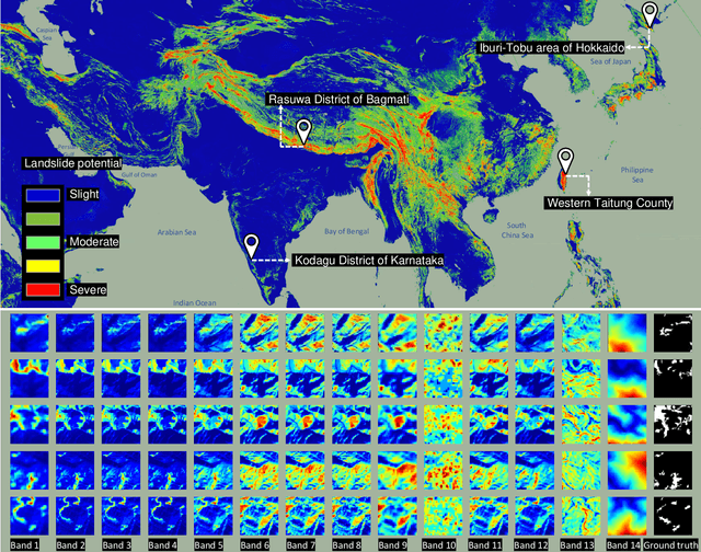
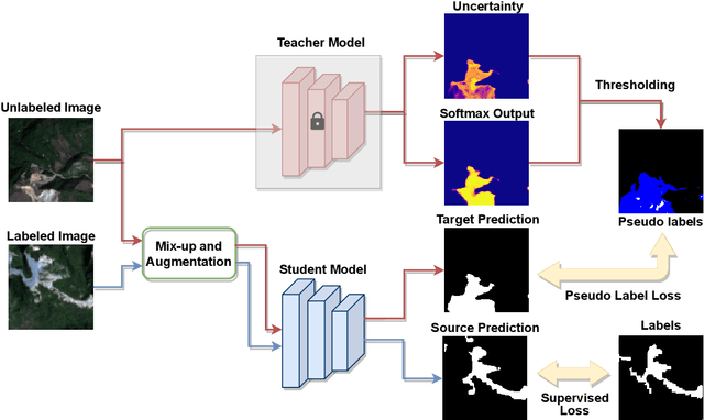
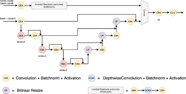
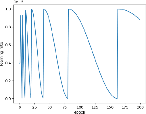
Abstract:The scientific outcomes of the 2022 Landslide4Sense (L4S) competition organized by the Institute of Advanced Research in Artificial Intelligence (IARAI) are presented here. The objective of the competition is to automatically detect landslides based on large-scale multiple sources of satellite imagery collected globally. The 2022 L4S aims to foster interdisciplinary research on recent developments in deep learning (DL) models for the semantic segmentation task using satellite imagery. In the past few years, DL-based models have achieved performance that meets expectations on image interpretation, due to the development of convolutional neural networks (CNNs). The main objective of this article is to present the details and the best-performing algorithms featured in this competition. The winning solutions are elaborated with state-of-the-art models like the Swin Transformer, SegFormer, and U-Net. Advanced machine learning techniques and strategies such as hard example mining, self-training, and mix-up data augmentation are also considered. Moreover, we describe the L4S benchmark data set in order to facilitate further comparisons, and report the results of the accuracy assessment online. The data is accessible on \textit{Future Development Leaderboard} for future evaluation at \url{https://www.iarai.ac.at/landslide4sense/challenge/}, and researchers are invited to submit more prediction results, evaluate the accuracy of their methods, compare them with those of other users, and, ideally, improve the landslide detection results reported in this article.
 Add to Chrome
 Add to Firefox
 Add to Edge