Yanfei Zhong
EarthVL: A Progressive Earth Vision-Language Understanding and Generation Framework
Jan 06, 2026Abstract:Earth vision has achieved milestones in geospatial object recognition but lacks exploration in object-relational reasoning, limiting comprehensive scene understanding. To address this, a progressive Earth vision-language understanding and generation framework is proposed, including a multi-task dataset (EarthVLSet) and a semantic-guided network (EarthVLNet). Focusing on city planning applications, EarthVLSet includes 10.9k sub-meter resolution remote sensing images, land-cover masks, and 761.5k textual pairs involving both multiple-choice and open-ended visual question answering (VQA) tasks. In an object-centric way, EarthVLNet is proposed to progressively achieve semantic segmentation, relational reasoning, and comprehensive understanding. The first stage involves land-cover segmentation to generate object semantics for VQA guidance. Guided by pixel-wise semantics, the object awareness based large language model (LLM) performs relational reasoning and knowledge summarization to generate the required answers. As for optimization, the numerical difference loss is proposed to dynamically add difference penalties, addressing the various objects' statistics. Three benchmarks, including semantic segmentation, multiple-choice, and open-ended VQA demonstrated the superiorities of EarthVLNet, yielding three future directions: 1) segmentation features consistently enhance VQA performance even in cross-dataset scenarios; 2) multiple-choice tasks show greater sensitivity to the vision encoder than to the language decoder; and 3) open-ended tasks necessitate advanced vision encoders and language decoders for an optimal performance. We believe this dataset and method will provide a beneficial benchmark that connects ''image-mask-text'', advancing geographical applications for Earth vision.
DynamicVL: Benchmarking Multimodal Large Language Models for Dynamic City Understanding
May 27, 2025Abstract:Multimodal large language models have demonstrated remarkable capabilities in visual understanding, but their application to long-term Earth observation analysis remains limited, primarily focusing on single-temporal or bi-temporal imagery. To address this gap, we introduce DVL-Suite, a comprehensive framework for analyzing long-term urban dynamics through remote sensing imagery. Our suite comprises 15,063 high-resolution (1.0m) multi-temporal images spanning 42 megacities in the U.S. from 2005 to 2023, organized into two components: DVL-Bench and DVL-Instruct. The DVL-Bench includes seven urban understanding tasks, from fundamental change detection (pixel-level) to quantitative analyses (regional-level) and comprehensive urban narratives (scene-level), capturing diverse urban dynamics including expansion/transformation patterns, disaster assessment, and environmental challenges. We evaluate 17 state-of-the-art multimodal large language models and reveal their limitations in long-term temporal understanding and quantitative analysis. These challenges motivate the creation of DVL-Instruct, a specialized instruction-tuning dataset designed to enhance models' capabilities in multi-temporal Earth observation. Building upon this dataset, we develop DVLChat, a baseline model capable of both image-level question-answering and pixel-level segmentation, facilitating a comprehensive understanding of city dynamics through language interactions.
HyperFree: A Channel-adaptive and Tuning-free Foundation Model for Hyperspectral Remote Sensing Imagery
Mar 27, 2025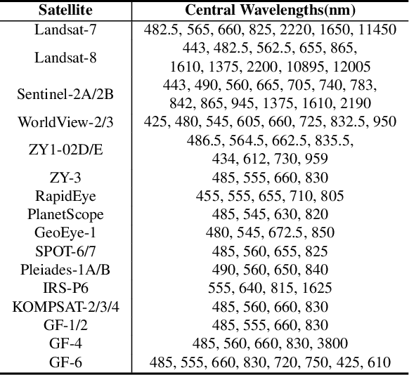

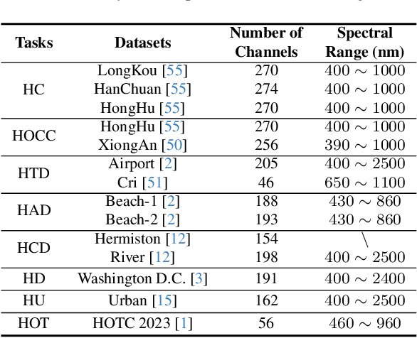
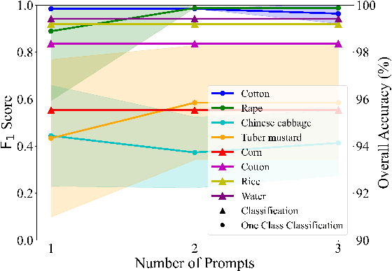
Abstract:Advanced interpretation of hyperspectral remote sensing images benefits many precise Earth observation tasks. Recently, visual foundation models have promoted the remote sensing interpretation but concentrating on RGB and multispectral images. Due to the varied hyperspectral channels,existing foundation models would face image-by-image tuning situation, imposing great pressure on hardware and time resources. In this paper, we propose a tuning-free hyperspectral foundation model called HyperFree, by adapting the existing visual prompt engineering. To process varied channel numbers, we design a learned weight dictionary covering full-spectrum from $0.4 \sim 2.5 \, \mu\text{m}$, supporting to build the embedding layer dynamically. To make the prompt design more tractable, HyperFree can generate multiple semantic-aware masks for one prompt by treating feature distance as semantic-similarity. After pre-training HyperFree on constructed large-scale high-resolution hyperspectral images, HyperFree (1 prompt) has shown comparable results with specialized models (5 shots) on 5 tasks and 11 datasets.Code and dataset are accessible at https://rsidea.whu.edu.cn/hyperfree.htm.
HOpenCls: Training Hyperspectral Image Open-Set Classifiers in Their Living Environments
Feb 21, 2025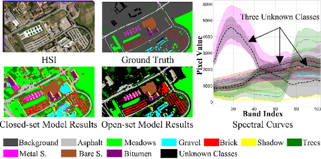
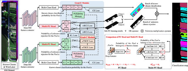
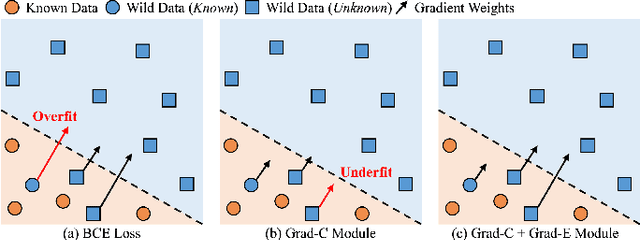

Abstract:Hyperspectral image (HSI) open-set classification is critical for HSI classification models deployed in real-world environments, where classifiers must simultaneously classify known classes and reject unknown classes. Recent methods utilize auxiliary unknown classes data to improve classification performance. However, the auxiliary unknown classes data is strongly assumed to be completely separable from known classes and requires labor-intensive annotation. To address this limitation, this paper proposes a novel framework, HOpenCls, to leverage the unlabeled wild data-that is the mixture of known and unknown classes. Such wild data is abundant and can be collected freely during deploying classifiers in their living environments. The key insight is reformulating the open-set HSI classification with unlabeled wild data as a positive-unlabeled (PU) learning problem. Specifically, the multi-label strategy is introduced to bridge the PU learning and open-set HSI classification, and then the proposed gradient contraction and gradient expansion module to make this PU learning problem tractable from the observation of abnormal gradient weights associated with wild data. Extensive experiment results demonstrate that incorporating wild data has the potential to significantly enhance open-set HSI classification in complex real-world scenarios.
Reverse Refinement Network for Narrow Rural Road Detection in High-Resolution Satellite Imagery
Oct 14, 2024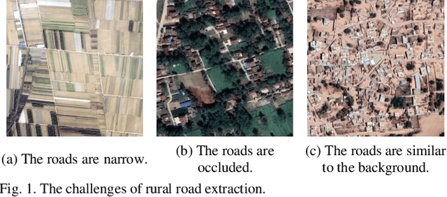
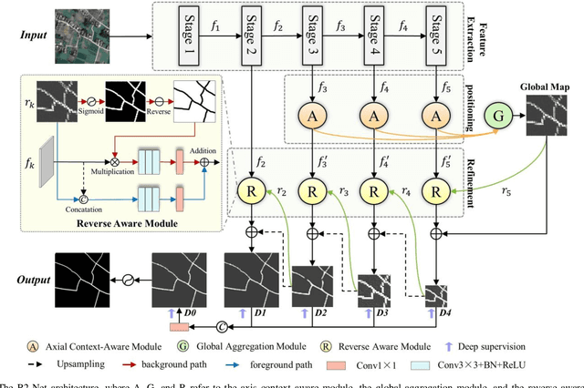
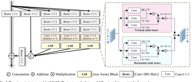
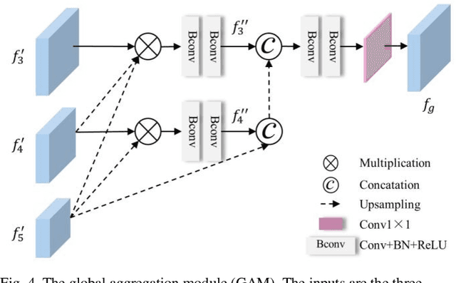
Abstract:The automated extraction of rural roads is pivotal for rural development and transportation planning, serving as a cornerstone for socio-economic progress. Current research primarily focuses on road extraction in urban areas. However, rural roads present unique challenges due to their narrow and irregular nature, posing significant difficulties for road extraction. In this article, a reverse refinement network (R2-Net) is proposed to extract narrow rural roads, enhancing their connectivity and distinctiveness from the background. Specifically, to preserve the fine details of roads within high-resolution feature maps, R2-Net utilizes an axis context aware module (ACAM) to capture the long-distance spatial context information in various layers. Subsequently, the multi-level features are aggregated through a global aggregation module (GAM). Moreover, in the decoder stage, R2-Net employs a reverse-aware module (RAM) to direct the attention of the network to the complex background, thus amplifying its separability. In experiments, we compare R2-Net with several state-of-the-art methods using the DeepGlobe road extraction dataset and the WHU-RuR+ global large-scale rural road dataset. R2-Net achieved superior performance and especially excelled in accurately detecting narrow roads. Furthermore, we explored the applicability of R2-Net for large-scale rural road mapping. The results show that the proposed R2-Net has significant performance advantages for large-scale rural road mapping applications.
AnomalyCD: A benchmark for Earth anomaly change detection with high-resolution and time-series observations
Sep 09, 2024


Abstract:Various Earth anomalies have destroyed the stable, balanced state, resulting in fatalities and serious destruction of property. With the advantages of large-scale and precise observation, high-resolution remote sensing images have been widely used for anomaly monitoring and localization. Powered by the deep representation, the existing methods have achieved remarkable advances, primarily in classification and change detection techniques. However, labeled samples are difficult to acquire due to the low probability of anomaly occurrence, and the trained models are limited to fixed anomaly categories, which hinders the application for anomalies with few samples or unknown anomalies. In this paper, to tackle this problem, we propose the anomaly change detection (AnomalyCD) technique, which accepts time-series observations and learns to identify anomalous changes by learning from the historical normal change pattern. Compared to the existing techniques, AnomalyCD processes an unfixed number of time steps and can localize the various anomalies in a unified manner, without human supervision. To benchmark AnomalyCD, we constructed a high-resolution dataset with time-series images dedicated to various Earth anomalies (the AnomalyCDD dataset). AnomalyCDD contains high-resolution (from 0.15 to 2.39 m/pixel), time-series (from 3 to 7 time steps), and large-scale images (1927.93 km2 in total) collected globally Furthermore, we developed a zero-shot baseline model (AnomalyCDM), which implements the AnomalyCD technique by extracting a general representation from the segment anything model (SAM) and conducting temporal comparison to distinguish the anomalous changes from normal changes. AnomalyCDM is designed as a two-stage workflow to enhance the efficiency, and has the ability to process the unseen images directly, without retraining for each scene.
Changen2: Multi-Temporal Remote Sensing Generative Change Foundation Model
Jun 26, 2024


Abstract:Our understanding of the temporal dynamics of the Earth's surface has been advanced by deep vision models, which often require lots of labeled multi-temporal images for training. However, collecting, preprocessing, and annotating multi-temporal remote sensing images at scale is non-trivial since it is expensive and knowledge-intensive. In this paper, we present change data generators based on generative models, which are cheap and automatic, alleviating these data problems. Our main idea is to simulate a stochastic change process over time. We describe the stochastic change process as a probabilistic graphical model (GPCM), which factorizes the complex simulation problem into two more tractable sub-problems, i.e., change event simulation and semantic change synthesis. To solve these two problems, we present Changen2, a GPCM with a resolution-scalable diffusion transformer which can generate time series of images and their semantic and change labels from labeled or unlabeled single-temporal images. Changen2 is a generative change foundation model that can be trained at scale via self-supervision, and can produce change supervisory signals from unlabeled single-temporal images. Unlike existing foundation models, Changen2 synthesizes change data to train task-specific foundation models for change detection. The resulting model possesses inherent zero-shot change detection capabilities and excellent transferability. Experiments suggest Changen2 has superior spatiotemporal scalability, e.g., Changen2 model trained on 256$^2$ pixel single-temporal images can yield time series of any length and resolutions of 1,024$^2$ pixels. Changen2 pre-trained models exhibit superior zero-shot performance (narrowing the performance gap to 3% on LEVIR-CD and approximately 10% on both S2Looking and SECOND, compared to fully supervised counterparts) and transferability across multiple types of change tasks.
Single-Temporal Supervised Learning for Universal Remote Sensing Change Detection
Jun 22, 2024Abstract:Bitemporal supervised learning paradigm always dominates remote sensing change detection using numerous labeled bitemporal image pairs, especially for high spatial resolution (HSR) remote sensing imagery. However, it is very expensive and labor-intensive to label change regions in large-scale bitemporal HSR remote sensing image pairs. In this paper, we propose single-temporal supervised learning (STAR) for universal remote sensing change detection from a new perspective of exploiting changes between unpaired images as supervisory signals. STAR enables us to train a high-accuracy change detector only using unpaired labeled images and can generalize to real-world bitemporal image pairs. To demonstrate the flexibility and scalability of STAR, we design a simple yet unified change detector, termed ChangeStar2, capable of addressing binary change detection, object change detection, and semantic change detection in one architecture. ChangeStar2 achieves state-of-the-art performances on eight public remote sensing change detection datasets, covering above two supervised settings, multiple change types, multiple scenarios. The code is available at https://github.com/Z-Zheng/pytorch-change-models.
Segment Any Change
Feb 02, 2024Abstract:Visual foundation models have achieved remarkable results in zero-shot image classification and segmentation, but zero-shot change detection remains an open problem. In this paper, we propose the segment any change models (AnyChange), a new type of change detection model that supports zero-shot prediction and generalization on unseen change types and data distributions. AnyChange is built on the segment anything model (SAM) via our training-free adaptation method, bitemporal latent matching. By revealing and exploiting intra-image and inter-image semantic similarities in SAM's latent space, bitemporal latent matching endows SAM with zero-shot change detection capabilities in a training-free way. We also propose a point query mechanism to enable AnyChange's zero-shot object-centric change detection capability. We perform extensive experiments to confirm the effectiveness of AnyChange for zero-shot change detection. AnyChange sets a new record on the SECOND benchmark for unsupervised change detection, exceeding the previous SOTA by up to 4.4% F$_1$ score, and achieving comparable accuracy with negligible manual annotations (1 pixel per image) for supervised change detection.
MapChange: Enhancing Semantic Change Detection with Temporal-Invariant Historical Maps Based on Deep Triplet Network
Jan 21, 2024


Abstract:Semantic Change Detection (SCD) is recognized as both a crucial and challenging task in the field of image analysis. Traditional methods for SCD have predominantly relied on the comparison of image pairs. However, this approach is significantly hindered by substantial imaging differences, which arise due to variations in shooting times, atmospheric conditions, and angles. Such discrepancies lead to two primary issues: the under-detection of minor yet significant changes, and the generation of false alarms due to temporal variances. These factors often result in unchanged objects appearing markedly different in multi-temporal images. In response to these challenges, the MapChange framework has been developed. This framework introduces a novel paradigm that synergizes temporal-invariant historical map data with contemporary high-resolution images. By employing this combination, the temporal variance inherent in conventional image pair comparisons is effectively mitigated. The efficacy of the MapChange framework has been empirically validated through comprehensive testing on two public datasets. These tests have demonstrated the framework's marked superiority over existing state-of-the-art SCD methods.
 Add to Chrome
 Add to Firefox
 Add to Edge