Heng Fang
Earth Embeddings as Products: Taxonomy, Ecosystem, and Standardized Access
Jan 19, 2026Abstract:Geospatial Foundation Models (GFMs) provide powerful representations, but high compute costs hinder their widespread use. Pre-computed embedding data products offer a practical "frozen" alternative, yet they currently exist in a fragmented ecosystem of incompatible formats and resolutions. This lack of standardization creates an engineering bottleneck that prevents meaningful model comparison and reproducibility. We formalize this landscape through a three-layer taxonomy: Data, Tools, and Value. We survey existing products to identify interoperability barriers. To bridge this gap, we extend TorchGeo with a unified API that standardizes the loading and querying of diverse embedding products. By treating embeddings as first-class geospatial datasets, we decouple downstream analysis from model-specific engineering, providing a roadmap for more transparent and accessible Earth observation workflows.
Leveraging Satellite Image Time Series for Accurate Extreme Event Detection
Jun 13, 2025Abstract:Climate change is leading to an increase in extreme weather events, causing significant environmental damage and loss of life. Early detection of such events is essential for improving disaster response. In this work, we propose SITS-Extreme, a novel framework that leverages satellite image time series to detect extreme events by incorporating multiple pre-disaster observations. This approach effectively filters out irrelevant changes while isolating disaster-relevant signals, enabling more accurate detection. Extensive experiments on both real-world and synthetic datasets validate the effectiveness of SITS-Extreme, demonstrating substantial improvements over widely used strong bi-temporal baselines. Additionally, we examine the impact of incorporating more timesteps, analyze the contribution of key components in our framework, and evaluate its performance across different disaster types, offering valuable insights into its scalability and applicability for large-scale disaster monitoring.
LineArt: A Knowledge-guided Training-free High-quality Appearance Transfer for Design Drawing with Diffusion Model
Dec 16, 2024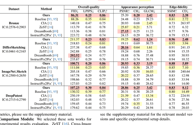
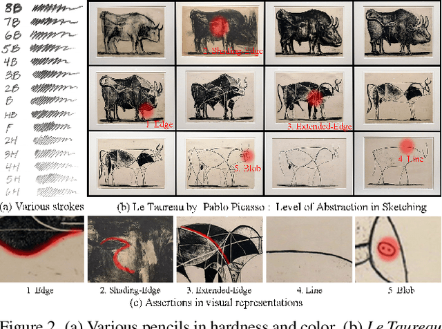

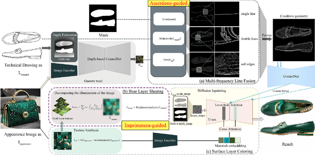
Abstract:Image rendering from line drawings is vital in design and image generation technologies reduce costs, yet professional line drawings demand preserving complex details. Text prompts struggle with accuracy, and image translation struggles with consistency and fine-grained control. We present LineArt, a framework that transfers complex appearance onto detailed design drawings, facilitating design and artistic creation. It generates high-fidelity appearance while preserving structural accuracy by simulating hierarchical visual cognition and integrating human artistic experience to guide the diffusion process. LineArt overcomes the limitations of current methods in terms of difficulty in fine-grained control and style degradation in design drawings. It requires no precise 3D modeling, physical property specs, or network training, making it more convenient for design tasks. LineArt consists of two stages: a multi-frequency lines fusion module to supplement the input design drawing with detailed structural information and a two-part painting process for Base Layer Shaping and Surface Layer Coloring. We also present a new design drawing dataset ProLines for evaluation. The experiments show that LineArt performs better in accuracy, realism, and material precision compared to SOTAs.
PANGAEA: A Global and Inclusive Benchmark for Geospatial Foundation Models
Dec 05, 2024Abstract:Geospatial Foundation Models (GFMs) have emerged as powerful tools for extracting representations from Earth observation data, but their evaluation remains inconsistent and narrow. Existing works often evaluate on suboptimal downstream datasets and tasks, that are often too easy or too narrow, limiting the usefulness of the evaluations to assess the real-world applicability of GFMs. Additionally, there is a distinct lack of diversity in current evaluation protocols, which fail to account for the multiplicity of image resolutions, sensor types, and temporalities, which further complicates the assessment of GFM performance. In particular, most existing benchmarks are geographically biased towards North America and Europe, questioning the global applicability of GFMs. To overcome these challenges, we introduce PANGAEA, a standardized evaluation protocol that covers a diverse set of datasets, tasks, resolutions, sensor modalities, and temporalities. It establishes a robust and widely applicable benchmark for GFMs. We evaluate the most popular GFMs openly available on this benchmark and analyze their performance across several domains. In particular, we compare these models to supervised baselines (e.g. UNet and vanilla ViT), and assess their effectiveness when faced with limited labeled data. Our findings highlight the limitations of GFMs, under different scenarios, showing that they do not consistently outperform supervised models. PANGAEA is designed to be highly extensible, allowing for the seamless inclusion of new datasets, models, and tasks in future research. By releasing the evaluation code and benchmark, we aim to enable other researchers to replicate our experiments and build upon our work, fostering a more principled evaluation protocol for large pre-trained geospatial models. The code is available at https://github.com/VMarsocci/pangaea-bench.
SAM-MIL: A Spatial Contextual Aware Multiple Instance Learning Approach for Whole Slide Image Classification
Jul 25, 2024
Abstract:Multiple Instance Learning (MIL) represents the predominant framework in Whole Slide Image (WSI) classification, covering aspects such as sub-typing, diagnosis, and beyond. Current MIL models predominantly rely on instance-level features derived from pretrained models such as ResNet. These models segment each WSI into independent patches and extract features from these local patches, leading to a significant loss of global spatial context and restricting the model's focus to merely local features. To address this issue, we propose a novel MIL framework, named SAM-MIL, that emphasizes spatial contextual awareness and explicitly incorporates spatial context by extracting comprehensive, image-level information. The Segment Anything Model (SAM) represents a pioneering visual segmentation foundational model that can capture segmentation features without the need for additional fine-tuning, rendering it an outstanding tool for extracting spatial context directly from raw WSIs. Our approach includes the design of group feature extraction based on spatial context and a SAM-Guided Group Masking strategy to mitigate class imbalance issues. We implement a dynamic mask ratio for different segmentation categories and supplement these with representative group features of categories. Moreover, SAM-MIL divides instances to generate additional pseudo-bags, thereby augmenting the training set, and introduces consistency of spatial context across pseudo-bags to further enhance the model's performance. Experimental results on the CAMELYON-16 and TCGA Lung Cancer datasets demonstrate that our proposed SAM-MIL model outperforms existing mainstream methods in WSIs classification. Our open-source implementation code is is available at https://github.com/FangHeng/SAM-MIL.
Continuous Urban Change Detection from Satellite Image Time Series with Temporal Feature Refinement and Multi-Task Integration
Jun 25, 2024
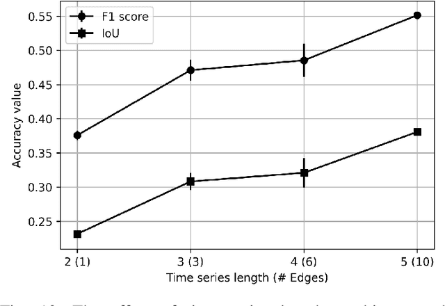
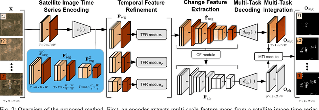

Abstract:Urbanization advances at unprecedented rates, resulting in negative effects on the environment and human well-being. Remote sensing has the potential to mitigate these effects by supporting sustainable development strategies with accurate information on urban growth. Deep learning-based methods have achieved promising urban change detection results from optical satellite image pairs using convolutional neural networks (ConvNets), transformers, and a multi-task learning setup. However, transformers have not been leveraged for urban change detection with multi-temporal data, i.e., >2 images, and multi-task learning methods lack integration approaches that combine change and segmentation outputs. To fill this research gap, we propose a continuous urban change detection method that identifies changes in each consecutive image pair of a satellite image time series. Specifically, we propose a temporal feature refinement (TFR) module that utilizes self-attention to improve ConvNet-based multi-temporal building representations. Furthermore, we propose a multi-task integration (MTI) module that utilizes Markov networks to find an optimal building map time series based on segmentation and dense change outputs. The proposed method effectively identifies urban changes based on high-resolution satellite image time series acquired by the PlanetScope constellation (F1 score 0.551) and Gaofen-2 (F1 score 0.440). Moreover, our experiments on two challenging datasets demonstrate the effectiveness of the proposed method compared to bi-temporal and multi-temporal urban change detection and segmentation methods.
FilterPrompt: Guiding Image Transfer in Diffusion Models
Apr 20, 2024Abstract:In controllable generation tasks, flexibly manipulating the generated images to attain a desired appearance or structure based on a single input image cue remains a critical and longstanding challenge. Achieving this requires the effective decoupling of key attributes within the input image data, aiming to get representations accurately. Previous research has predominantly concentrated on disentangling image attributes within feature space. However, the complex distribution present in real-world data often makes the application of such decoupling algorithms to other datasets challenging. Moreover, the granularity of control over feature encoding frequently fails to meet specific task requirements. Upon scrutinizing the characteristics of various generative models, we have observed that the input sensitivity and dynamic evolution properties of the diffusion model can be effectively fused with the explicit decomposition operation in pixel space. This integration enables the image processing operations performed in pixel space for a specific feature distribution of the input image, and can achieve the desired control effect in the generated results. Therefore, we propose FilterPrompt, an approach to enhance the model control effect. It can be universally applied to any diffusion model, allowing users to adjust the representation of specific image features in accordance with task requirements, thereby facilitating more precise and controllable generation outcomes. In particular, our designed experiments demonstrate that the FilterPrompt optimizes feature correlation, mitigates content conflicts during the generation process, and enhances the model's control capability.
DeFlow: Decoder of Scene Flow Network in Autonomous Driving
Jan 29, 2024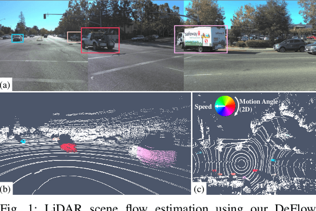
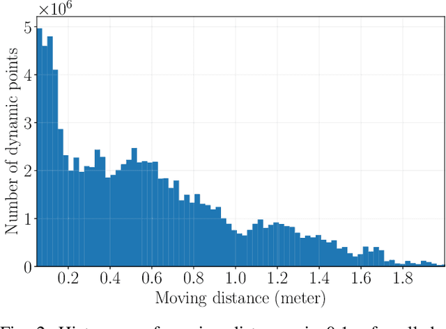

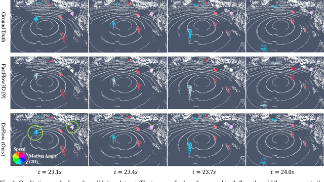
Abstract:Scene flow estimation determines a scene's 3D motion field, by predicting the motion of points in the scene, especially for aiding tasks in autonomous driving. Many networks with large-scale point clouds as input use voxelization to create a pseudo-image for real-time running. However, the voxelization process often results in the loss of point-specific features. This gives rise to a challenge in recovering those features for scene flow tasks. Our paper introduces DeFlow which enables a transition from voxel-based features to point features using Gated Recurrent Unit (GRU) refinement. To further enhance scene flow estimation performance, we formulate a novel loss function that accounts for the data imbalance between static and dynamic points. Evaluations on the Argoverse 2 scene flow task reveal that DeFlow achieves state-of-the-art results on large-scale point cloud data, demonstrating that our network has better performance and efficiency compared to others. The code is open-sourced at https://github.com/KTH-RPL/deflow.
Brain Surface Reconstruction from MRI Images Based on Segmentation Networks Applying Signed Distance Maps
Apr 09, 2021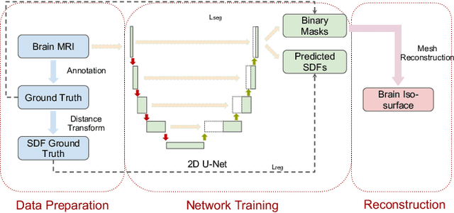

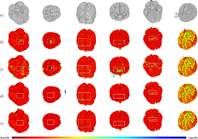
Abstract:Whole-brain surface extraction is an essential topic in medical imaging systems as it provides neurosurgeons with a broader view of surgical planning and abnormality detection. To solve the problem confronted in current deep learning skull stripping methods lacking prior shape information, we propose a new network architecture that incorporates knowledge of signed distance fields and introduce an additional Laplacian loss to ensure that the prediction results retain shape information. We validated our newly proposed method by conducting experiments on our brain magnetic resonance imaging dataset (111 patients). The evaluation results demonstrate that our approach achieves comparable dice scores and also reduces the Hausdorff distance and average symmetric surface distance, thus producing more stable and smooth brain isosurfaces.
 Add to Chrome
 Add to Firefox
 Add to Edge