 Add to Chrome
 Add to Firefox
 Add to Edge
Low-Rank Adaptation of Geospatial Foundation Models for Wildfire Mapping Using Sentinel-2 Data
May 06, 2026Wildfire burned-area mapping is essential for damage assessment, emissions modeling, and understanding fire-climate interactions across diverse ecological regions. Recent geospatial foundation models provide strong general-purpose representations for satellite imagery, yet there is still no clear understanding of how to efficiently adapt these models for downstream Earth observation tasks, particularly under geographic and temporal domain shift. This study evaluates three state-of-the-art Geospatial Foundation Models (GFMs) - Terramind, DINOv3, and Prithvi-v2 - for burned-area mapping across the United States and Canada using Sentinel-2 data. Leveraging 3,820 wildfire events from 2017-2023, we conduct spatial and temporal generalization tests across diverse biomes. We systematically compare full fine-tuning, decoder-only fine-tuning, and Low-Rank Adaptation (LoRA) for adapting each model. Across all experiments, LoRA provides the strongest cross-domain generalization while updating less than 1% of parameters, demonstrating a favorable trade-off between accuracy and efficiency. Prithvi-v2 with LoRA achieves the highest overall accuracy and the largest improvement compared to full fine-tuning. These findings indicate that geospatial foundation models, when adapted using lightweight parameter-efficient methods such as LoRA, offer a robust and scalable solution for large-scale burned-area mapping. Code is available at https://github.com/alishibli97/wildfire-lora-gfm.
GeoHeight-Bench: Towards Height-Aware Multimodal Reasoning in Remote Sensing
Mar 26, 2026Current Large Multimodal Models (LMMs) in Earth Observation typically neglect the critical "vertical" dimension, limiting their reasoning capabilities in complex remote sensing geometries and disaster scenarios where physical spatial structures often outweigh planar visual textures. To bridge this gap, we introduce a comprehensive evaluation framework dedicated to height-aware remote sensing understanding. First, to overcome the severe scarcity of annotated data, we develop a scalable, VLM-driven data generation pipeline utilizing systematic prompt engineering and metadata extraction. This pipeline constructs two complementary benchmarks: GeoHeight-Bench for relative height analysis, and a more challenging GeoHeight-Bench+ for holistic, terrain-aware reasoning. Furthermore, to validate the necessity of height perception, we propose GeoHeightChat, the first height-aware remote sensing LMM baseline. Serving as a strong proof of concept, our baseline demonstrates that synergizing visual semantics with implicitly injected height geometric features effectively mitigates the "vertical blind spot", successfully unlocking a new paradigm of interactive height reasoning in existing optical models.
TS-SatFire: A Multi-Task Satellite Image Time-Series Dataset for Wildfire Detection and Prediction
Dec 16, 2024


Wildfire monitoring and prediction are essential for understanding wildfire behaviour. With extensive Earth observation data, these tasks can be integrated and enhanced through multi-task deep learning models. We present a comprehensive multi-temporal remote sensing dataset for active fire detection, daily wildfire monitoring, and next-day wildfire prediction. Covering wildfire events in the contiguous U.S. from January 2017 to October 2021, the dataset includes 3552 surface reflectance images and auxiliary data such as weather, topography, land cover, and fuel information, totalling 71 GB. The lifecycle of each wildfire is documented, with labels for active fires (AF) and burned areas (BA), supported by manual quality assurance of AF and BA test labels. The dataset supports three tasks: a) active fire detection, b) daily burned area mapping, and c) wildfire progression prediction. Detection tasks use pixel-wise classification of multi-spectral, multi-temporal images, while prediction tasks integrate satellite and auxiliary data to model fire dynamics. This dataset and its benchmarks provide a foundation for advancing wildfire research using deep learning.
RADARSAT Constellation Mission Compact Polarisation SAR Data for Burned Area Mapping with Deep Learning
Dec 16, 2024Monitoring wildfires has become increasingly critical due to the sharp rise in wildfire incidents in recent years. Optical satellites like Sentinel-2 and Landsat are extensively utilized for mapping burned areas. However, the effectiveness of optical sensors is compromised by clouds and smoke, which obstruct the detection of burned areas. Thus, satellites equipped with Synthetic Aperture Radar (SAR), such as dual-polarization Sentinel-1 and quad-polarization RADARSAT-1/-2 C-band SAR, which can penetrate clouds and smoke, are investigated for mapping burned areas. However, there is limited research on using compact polarisation (compact-pol) C-band RADARSAT Constellation Mission (RCM) SAR data for this purpose. This study aims to investigate the capacity of compact polarisation RCM data for burned area mapping through deep learning. Compact-pol m-chi decomposition and Compact-pol Radar Vegetation Index (CpRVI) are derived from the RCM Multi-look Complex product. A deep-learning-based processing pipeline incorporating ConvNet-based and Transformer-based models is applied for burned area mapping, with three different input settings: using only log-ratio dual-polarization intensity images images, using only compact-pol decomposition plus CpRVI, and using all three data sources. The results demonstrate that compact-pol m-chi decomposition and CpRVI images significantly complement log-ratio images for burned area mapping. The best-performing Transformer-based model, UNETR, trained with log-ratio, m-chi decomposition, and CpRVI data, achieved an F1 Score of 0.718 and an IoU Score of 0.565, showing a notable improvement compared to the same model trained using only log-ratio images.
PANGAEA: A Global and Inclusive Benchmark for Geospatial Foundation Models
Dec 05, 2024Geospatial Foundation Models (GFMs) have emerged as powerful tools for extracting representations from Earth observation data, but their evaluation remains inconsistent and narrow. Existing works often evaluate on suboptimal downstream datasets and tasks, that are often too easy or too narrow, limiting the usefulness of the evaluations to assess the real-world applicability of GFMs. Additionally, there is a distinct lack of diversity in current evaluation protocols, which fail to account for the multiplicity of image resolutions, sensor types, and temporalities, which further complicates the assessment of GFM performance. In particular, most existing benchmarks are geographically biased towards North America and Europe, questioning the global applicability of GFMs. To overcome these challenges, we introduce PANGAEA, a standardized evaluation protocol that covers a diverse set of datasets, tasks, resolutions, sensor modalities, and temporalities. It establishes a robust and widely applicable benchmark for GFMs. We evaluate the most popular GFMs openly available on this benchmark and analyze their performance across several domains. In particular, we compare these models to supervised baselines (e.g. UNet and vanilla ViT), and assess their effectiveness when faced with limited labeled data. Our findings highlight the limitations of GFMs, under different scenarios, showing that they do not consistently outperform supervised models. PANGAEA is designed to be highly extensible, allowing for the seamless inclusion of new datasets, models, and tasks in future research. By releasing the evaluation code and benchmark, we aim to enable other researchers to replicate our experiments and build upon our work, fostering a more principled evaluation protocol for large pre-trained geospatial models. The code is available at https://github.com/VMarsocci/pangaea-bench.
Continuous Urban Change Detection from Satellite Image Time Series with Temporal Feature Refinement and Multi-Task Integration
Jun 25, 2024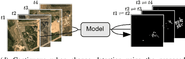
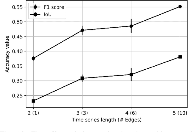
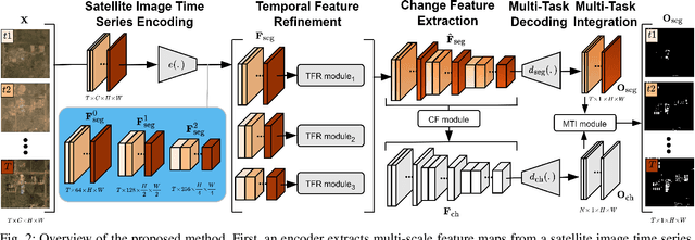
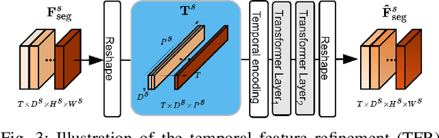
Urbanization advances at unprecedented rates, resulting in negative effects on the environment and human well-being. Remote sensing has the potential to mitigate these effects by supporting sustainable development strategies with accurate information on urban growth. Deep learning-based methods have achieved promising urban change detection results from optical satellite image pairs using convolutional neural networks (ConvNets), transformers, and a multi-task learning setup. However, transformers have not been leveraged for urban change detection with multi-temporal data, i.e., >2 images, and multi-task learning methods lack integration approaches that combine change and segmentation outputs. To fill this research gap, we propose a continuous urban change detection method that identifies changes in each consecutive image pair of a satellite image time series. Specifically, we propose a temporal feature refinement (TFR) module that utilizes self-attention to improve ConvNet-based multi-temporal building representations. Furthermore, we propose a multi-task integration (MTI) module that utilizes Markov networks to find an optimal building map time series based on segmentation and dense change outputs. The proposed method effectively identifies urban changes based on high-resolution satellite image time series acquired by the PlanetScope constellation (F1 score 0.551) and Gaofen-2 (F1 score 0.440). Moreover, our experiments on two challenging datasets demonstrate the effectiveness of the proposed method compared to bi-temporal and multi-temporal urban change detection and segmentation methods.
A CNN regression model to estimate buildings height maps using Sentinel-1 SAR and Sentinel-2 MSI time series
Jul 03, 2023Accurate estimation of building heights is essential for urban planning, infrastructure management, and environmental analysis. In this study, we propose a supervised Multimodal Building Height Regression Network (MBHR-Net) for estimating building heights at 10m spatial resolution using Sentinel-1 (S1) and Sentinel-2 (S2) satellite time series. S1 provides Synthetic Aperture Radar (SAR) data that offers valuable information on building structures, while S2 provides multispectral data that is sensitive to different land cover types, vegetation phenology, and building shadows. Our MBHR-Net aims to extract meaningful features from the S1 and S2 images to learn complex spatio-temporal relationships between image patterns and building heights. The model is trained and tested in 10 cities in the Netherlands. Root Mean Squared Error (RMSE), Intersection over Union (IOU), and R-squared (R2) score metrics are used to evaluate the performance of the model. The preliminary results (3.73m RMSE, 0.95 IoU, 0.61 R2) demonstrate the effectiveness of our deep learning model in accurately estimating building heights, showcasing its potential for urban planning, environmental impact analysis, and other related applications.
Context-Aware Change Detection With Semi-Supervised Learning
Jun 15, 2023


Change detection using earth observation data plays a vital role in quantifying the impact of disasters in affected areas. While data sources like Sentinel-2 provide rich optical information, they are often hindered by cloud cover, limiting their usage in disaster scenarios. However, leveraging pre-disaster optical data can offer valuable contextual information about the area such as landcover type, vegetation cover, soil types, enabling a better understanding of the disaster's impact. In this study, we develop a model to assess the contribution of pre-disaster Sentinel-2 data in change detection tasks, focusing on disaster-affected areas. The proposed Context-Aware Change Detection Network (CACDN) utilizes a combination of pre-disaster Sentinel-2 data, pre and post-disaster Sentinel-1 data and ancillary Digital Elevation Models (DEM) data. The model is validated on flood and landslide detection and evaluated using three metrics: Area Under the Precision-Recall Curve (AUPRC), Intersection over Union (IoU), and mean IoU. The preliminary results show significant improvement (4\%, AUPRC, 3-7\% IoU, 3-6\% mean IoU) in model's change detection capabilities when incorporated with pre-disaster optical data reflecting the effectiveness of using contextual information for accurate flood and landslide detection.
Multi-Modal Deep Learning for Multi-Temporal Urban Mapping With a Partly Missing Optical Modality
Jun 01, 2023


This paper proposes a novel multi-temporal urban mapping approach using multi-modal satellite data from the Sentinel-1 Synthetic Aperture Radar (SAR) and Sentinel-2 MultiSpectral Instrument (MSI) missions. In particular, it focuses on the problem of a partly missing optical modality due to clouds. The proposed model utilizes two networks to extract features from each modality separately. In addition, a reconstruction network is utilized to approximate the optical features based on the SAR data in case of a missing optical modality. Our experiments on a multi-temporal urban mapping dataset with Sentinel-1 SAR and Sentinel-2 MSI data demonstrate that the proposed method outperforms a multi-modal approach that uses zero values as a replacement for missing optical data, as well as a uni-modal SAR-based approach. Therefore, the proposed method is effective in exploiting multi-modal data, if available, but it also retains its effectiveness in case the optical modality is missing.
Investigating Imbalances Between SAR and Optical Utilization for Multi-Modal Urban Mapping
Apr 11, 2023


Accurate urban maps provide essential information to support sustainable urban development. Recent urban mapping methods use multi-modal deep neural networks to fuse Synthetic Aperture Radar (SAR) and optical data. However, multi-modal networks may rely on just one modality due to the greedy nature of learning. In turn, the imbalanced utilization of modalities can negatively affect the generalization ability of a network. In this paper, we investigate the utilization of SAR and optical data for urban mapping. To that end, a dual-branch network architecture using intermediate fusion modules to share information between the uni-modal branches is utilized. A cut-off mechanism in the fusion modules enables the stopping of information flow between the branches, which is used to estimate the network's dependence on SAR and optical data. While our experiments on the SEN12 Global Urban Mapping dataset show that good performance can be achieved with conventional SAR-optical data fusion (F1 score = 0.682 $\pm$ 0.014), we also observed a clear under-utilization of optical data. Therefore, future work is required to investigate whether a more balanced utilization of SAR and optical data can lead to performance improvements.