Weipeng Guan
SuperEIO: Self-Supervised Event Feature Learning for Event Inertial Odometry
Mar 29, 2025Abstract:Event cameras asynchronously output low-latency event streams, promising for state estimation in high-speed motion and challenging lighting conditions. As opposed to frame-based cameras, the motion-dependent nature of event cameras presents persistent challenges in achieving robust event feature detection and matching. In recent years, learning-based approaches have demonstrated superior robustness over traditional handcrafted methods in feature detection and matching, particularly under aggressive motion and HDR scenarios. In this paper, we propose SuperEIO, a novel framework that leverages the learning-based event-only detection and IMU measurements to achieve event-inertial odometry. Our event-only feature detection employs a convolutional neural network under continuous event streams. Moreover, our system adopts the graph neural network to achieve event descriptor matching for loop closure. The proposed system utilizes TensorRT to accelerate the inference speed of deep networks, which ensures low-latency processing and robust real-time operation on resource-limited platforms. Besides, we evaluate our method extensively on multiple public datasets, demonstrating its superior accuracy and robustness compared to other state-of-the-art event-based methods. We have also open-sourced our pipeline to facilitate research in the field: https://github.com/arclab-hku/SuperEIO.
DEIO: Deep Event Inertial Odometry
Nov 06, 2024Abstract:Event cameras are bio-inspired, motion-activated sensors that demonstrate impressive potential in handling challenging situations, such as motion blur and high-dynamic range. Despite their promise, existing event-based simultaneous localization and mapping (SLAM) approaches exhibit limited performance in real-world applications. On the other hand, state-of-the-art SLAM approaches that incorporate deep neural networks for better robustness and applicability. However, these is a lack of research in fusing learning-based event SLAM methods with IMU, which could be indispensable to push the event-based SLAM to large-scale, low-texture or complex scenarios. In this paper, we propose DEIO, the first monocular deep event-inertial odometry framework that combines learning-based method with traditional nonlinear graph-based optimization. Specifically, we tightly integrate a trainable event-based differentiable bundle adjustment (e-DBA) with the IMU pre-integration in a factor graph which employs keyframe-based sliding window optimization. Numerical Experiments in nine public challenge datasets show that our method can achieve superior performance compared with the image-based and event-based benchmarks. The source code is available at: https://github.com/arclab-hku/DEIO.
LVI-GS: Tightly-coupled LiDAR-Visual-Inertial SLAM using 3D Gaussian Splatting
Nov 05, 2024


Abstract:3D Gaussian Splatting (3DGS) has shown its ability in rapid rendering and high-fidelity mapping. In this paper, we introduce LVI-GS, a tightly-coupled LiDAR-Visual-Inertial mapping framework with 3DGS, which leverages the complementary characteristics of LiDAR and image sensors to capture both geometric structures and visual details of 3D scenes. To this end, the 3D Gaussians are initialized from colourized LiDAR points and optimized using differentiable rendering. In order to achieve high-fidelity mapping, we introduce a pyramid-based training approach to effectively learn multi-level features and incorporate depth loss derived from LiDAR measurements to improve geometric feature perception. Through well-designed strategies for Gaussian-Map expansion, keyframe selection, thread management, and custom CUDA acceleration, our framework achieves real-time photo-realistic mapping. Numerical experiments are performed to evaluate the superior performance of our method compared to state-of-the-art 3D reconstruction systems.
EVI-SAM: Robust, Real-time, Tightly-coupled Event-Visual-Inertial State Estimation and 3D Dense Mapping
Dec 19, 2023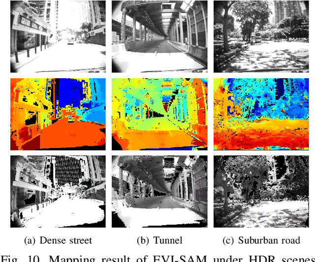
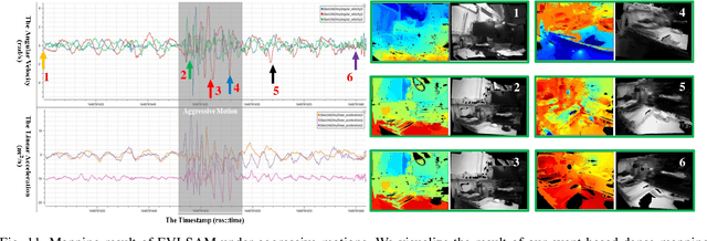
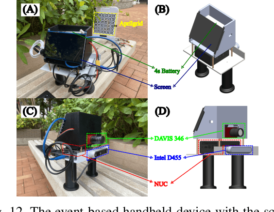
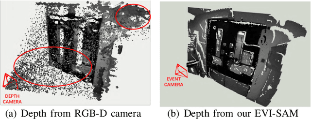
Abstract:Event cameras are bio-inspired, motion-activated sensors that demonstrate substantial potential in handling challenging situations, such as motion blur and high-dynamic range. In this paper, we proposed EVI-SAM to tackle the problem of 6 DoF pose tracking and 3D reconstruction using monocular event camera. A novel event-based hybrid tracking framework is designed to estimate the pose, leveraging the robustness of feature matching and the precision of direct alignment. Specifically, we develop an event-based 2D-2D alignment to construct the photometric constraint, and tightly integrate it with the event-based reprojection constraint. The mapping module recovers the dense and colorful depth of the scene through the image-guided event-based mapping method. Subsequently, the appearance, texture, and surface mesh of the 3D scene can be reconstructed by fusing the dense depth map from multiple viewpoints using truncated signed distance function (TSDF) fusion. To the best of our knowledge, this is the first non-learning work to realize event-based dense mapping. Numerical evaluations are performed on both publicly available and self-collected datasets, which qualitatively and quantitatively demonstrate the superior performance of our method. Our EVI-SAM effectively balances accuracy and robustness while maintaining computational efficiency, showcasing superior pose tracking and dense mapping performance in challenging scenarios. Video Demo: https://youtu.be/Nn40U4e5Si8.
ECMD: An Event-Centric Multisensory Driving Dataset for SLAM
Nov 04, 2023Abstract:Leveraging multiple sensors enhances complex environmental perception and increases resilience to varying luminance conditions and high-speed motion patterns, achieving precise localization and mapping. This paper proposes, ECMD, an event-centric multisensory dataset containing 81 sequences and covering over 200 km of various challenging driving scenarios including high-speed motion, repetitive scenarios, dynamic objects, etc. ECMD provides data from two sets of stereo event cameras with different resolutions (640*480, 346*260), stereo industrial cameras, an infrared camera, a top-installed mechanical LiDAR with two slanted LiDARs, two consumer-level GNSS receivers, and an onboard IMU. Meanwhile, the ground-truth of the vehicle was obtained using a centimeter-level high-accuracy GNSS-RTK/INS navigation system. All sensors are well-calibrated and temporally synchronized at the hardware level, with recording data simultaneously. We additionally evaluate several state-of-the-art SLAM algorithms for benchmarking visual and LiDAR SLAM and identifying their limitations. The dataset is available at https://arclab-hku.github.io/ecmd/.
ESVIO: Event-based Stereo Visual Inertial Odometry
Dec 26, 2022Abstract:Event cameras that asynchronously output low-latency event streams provide great opportunities for state estimation under challenging situations. Despite event-based visual odometry having been extensively studied in recent years, most of them are based on monocular and few research on stereo event vision. In this paper, we present ESVIO, the first event-based stereo visual-inertial odometry, which leverages the complementary advantages of event streams, standard images and inertial measurements. Our proposed pipeline achieves temporal tracking and instantaneous matching between consecutive stereo event streams, thereby obtaining robust state estimation. In addition, the motion compensation method is designed to emphasize the edge of scenes by warping each event to reference moments with IMU and ESVIO back-end. We validate that both ESIO (purely event-based) and ESVIO (event with image-aided) have superior performance compared with other image-based and event-based baseline methods on public and self-collected datasets. Furthermore, we use our pipeline to perform onboard quadrotor flights under low-light environments. A real-world large-scale experiment is also conducted to demonstrate long-term effectiveness. We highlight that this work is a real-time, accurate system that is aimed at robust state estimation under challenging environments.
A geometry method for LED mapping
Oct 28, 2022


Abstract:With inputs from RGB-D camera, industrial camera and wheel odometer, in this letter, we propose a geometry-based detecting method, by which the 3-D modulated LED map can be acquired with the aid of visual odometry algorithm from ORB-SLAM2 system when the decoding result of LED-ID is inaccurate. Subsequently, an enhanced cost function is proposed to optimize the mapping result of LEDs. The average 3-D mapping error (8.5cm) is evaluated with a real-world experiment. This work can be viewed as a preliminary work of visible light positioning systems, offering a way to prevent the labor-intensive manual site surveys of LEDs.
PL-EVIO: Robust Monocular Event-based Visual Inertial Odometry with Point and Line Features
Sep 25, 2022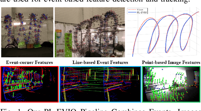

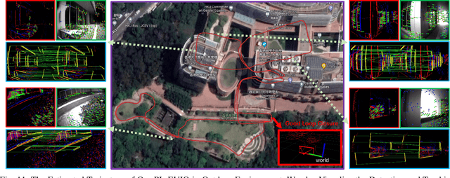
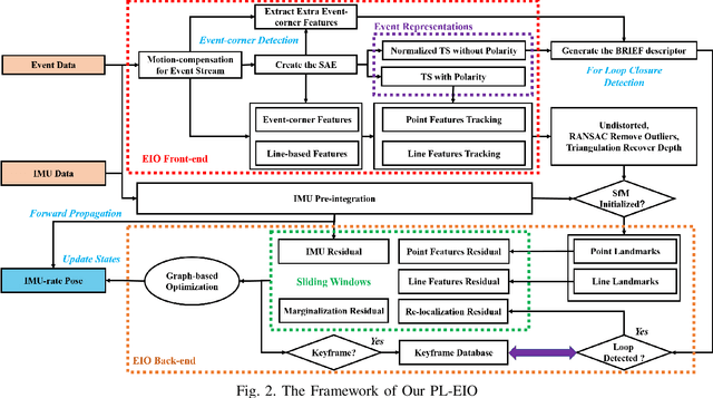
Abstract:Event cameras are motion-activated sensors that capture pixel-level illumination changes instead of the intensity image with a fixed frame rate. Compared with the standard cameras, it can provide reliable visual perception during high-speed motions and in high dynamic range scenarios. However, event cameras output only a little information or even noise when the relative motion between the camera and the scene is limited, such as in a still state. While standard cameras can provide rich perception information in most scenarios, especially in good lighting conditions. These two cameras are exactly complementary. In this paper, we proposed a robust, high-accurate, and real-time optimization-based monocular event-based visual-inertial odometry (VIO) method with event-corner features, line-based event features, and point-based image features. The proposed method offers to leverage the point-based features in the nature scene and line-based features in the human-made scene to provide more additional structure or constraints information through well-design feature management. Experiments in the public benchmark datasets show that our method can achieve superior performance compared with the state-of-the-art image-based or event-based VIO. Finally, we used our method to demonstrate an onboard closed-loop autonomous quadrotor flight and large-scale outdoor experiments. Videos of the evaluations are presented on our project website: https://b23.tv/OE3QM6j
A Cooperative Positioning Flamework for Robot and Smart Phone Based on Visible Light Communication
Aug 25, 2022Abstract:A cooperative positioning flamework of human and robots based on visible light communication (VLC) is proposed. Based on the experiment system, we demonstrated it has high accuracy and real-time performance.
Efficient demodulation scheme for multilevel modulation based optical camera communication
Jan 15, 2022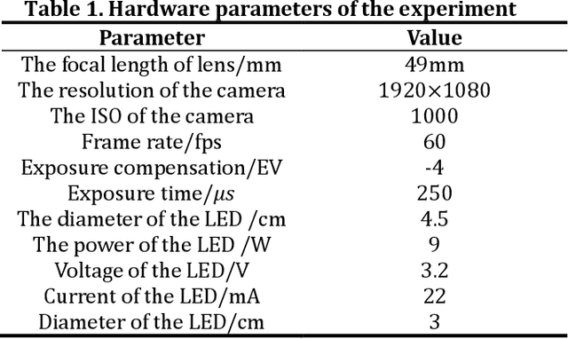
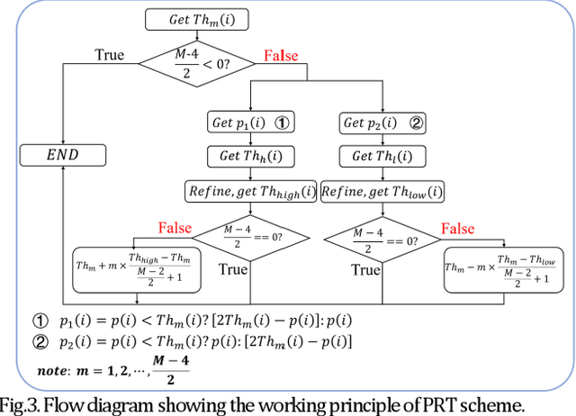
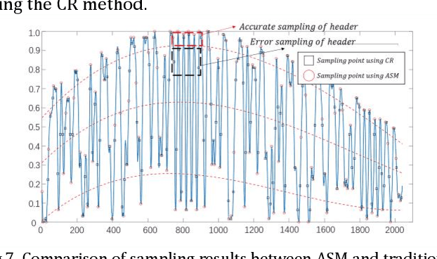
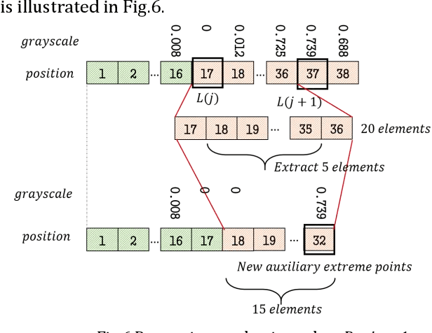
Abstract:We proposed and experimentally demonstrated a new hybrid code structure based on the overlapping of two light sources to produce the effect of multi-voltage amplitudes. And we also proposed an efficient polarity reversal threshold (RRT) algorithm for multilevel based OCC system. Then taking the issue of SPO into account, a novel adaptive sampling method (ASM) is proposed, which can effectively alleviate the problem of SPO and further enhance the performance of multilevel OCC. It is demonstrated that a data rate of 8.4 Kbit/s can be achieved by applying the proposed two algorithms.
 Add to Chrome
 Add to Firefox
 Add to Edge