Mang Tik Chiu
UniSER: A Foundation Model for Unified Soft Effects Removal
Nov 18, 2025Abstract:Digital images are often degraded by soft effects such as lens flare, haze, shadows, and reflections, which reduce aesthetics even though the underlying pixels remain partially visible. The prevailing works address these degradations in isolation, developing highly specialized, specialist models that lack scalability and fail to exploit the shared underlying essences of these restoration problems. While specialist models are limited, recent large-scale pretrained generalist models offer powerful, text-driven image editing capabilities. while recent general-purpose systems (e.g., GPT-4o, Flux Kontext, Nano Banana) require detailed prompts and often fail to achieve robust removal on these fine-grained tasks or preserve identity of the scene. Leveraging the common essence of soft effects, i.e., semi-transparent occlusions, we introduce a foundational versatile model UniSER, capable of addressing diverse degradations caused by soft effects within a single framework. Our methodology centers on curating a massive 3.8M-pair dataset to ensure robustness and generalization, which includes novel, physically-plausible data to fill critical gaps in public benchmarks, and a tailored training pipeline that fine-tunes a Diffusion Transformer to learn robust restoration priors from this diverse data, integrating fine-grained mask and strength controls. This synergistic approach allows UniSER to significantly outperform both specialist and generalist models, achieving robust, high-fidelity restoration in the wild.
Automatic High Resolution Wire Segmentation and Removal
Apr 01, 2023


Abstract:Wires and powerlines are common visual distractions that often undermine the aesthetics of photographs. The manual process of precisely segmenting and removing them is extremely tedious and may take up hours, especially on high-resolution photos where wires may span the entire space. In this paper, we present an automatic wire clean-up system that eases the process of wire segmentation and removal/inpainting to within a few seconds. We observe several unique challenges: wires are thin, lengthy, and sparse. These are rare properties of subjects that common segmentation tasks cannot handle, especially in high-resolution images. We thus propose a two-stage method that leverages both global and local contexts to accurately segment wires in high-resolution images efficiently, and a tile-based inpainting strategy to remove the wires given our predicted segmentation masks. We also introduce the first wire segmentation benchmark dataset, WireSegHR. Finally, we demonstrate quantitatively and qualitatively that our wire clean-up system enables fully automated wire removal with great generalization to various wire appearances.
The 1st Agriculture-Vision Challenge: Methods and Results
Apr 23, 2020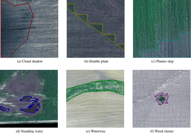
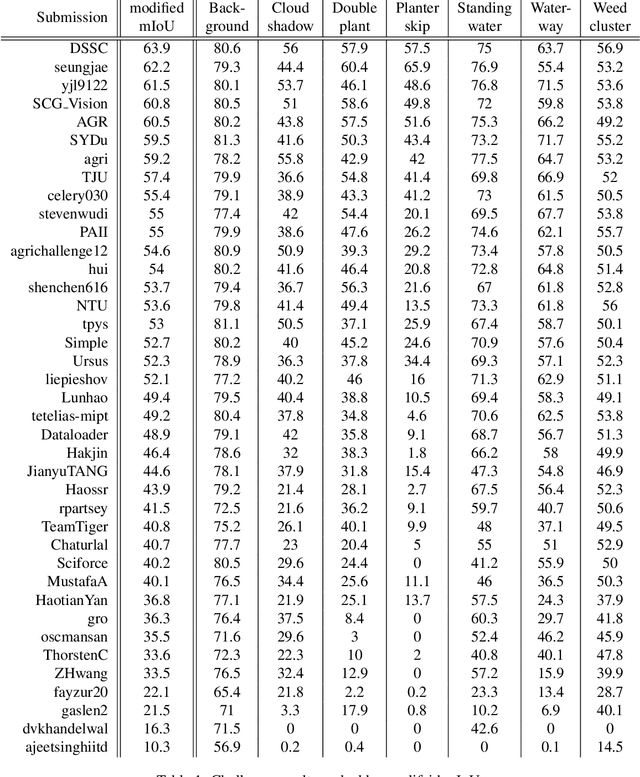
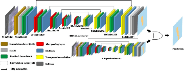

Abstract:The first Agriculture-Vision Challenge aims to encourage research in developing novel and effective algorithms for agricultural pattern recognition from aerial images, especially for the semantic segmentation task associated with our challenge dataset. Around 57 participating teams from various countries compete to achieve state-of-the-art in aerial agriculture semantic segmentation. The Agriculture-Vision Challenge Dataset was employed, which comprises of 21,061 aerial and multi-spectral farmland images. This paper provides a summary of notable methods and results in the challenge. Our submission server and leaderboard will continue to open for researchers that are interested in this challenge dataset and task; the link can be found here.
Deep Affinity Net: Instance Segmentation via Affinity
Mar 15, 2020


Abstract:Most of the modern instance segmentation approaches fall into two categories: region-based approaches in which object bounding boxes are detected first and later used in cropping and segmenting instances; and keypoint-based approaches in which individual instances are represented by a set of keypoints followed by a dense pixel clustering around those keypoints. Despite the maturity of these two paradigms, we would like to report an alternative affinity-based paradigm where instances are segmented based on densely predicted affinities and graph partitioning algorithms. Such affinity-based approaches indicate that high-level graph features other than regions or keypoints can be directly applied in the instance segmentation task. In this work, we propose Deep Affinity Net, an effective affinity-based approach accompanied with a new graph partitioning algorithm Cascade-GAEC. Without bells and whistles, our end-to-end model results in 32.4% AP on Cityscapes val and 27.5% AP on test. It achieves the best single-shot result as well as the fastest running time among all affinity-based models. It also outperforms the region-based method Mask R-CNN.
Agriculture-Vision: A Large Aerial Image Database for Agricultural Pattern Analysis
Jan 05, 2020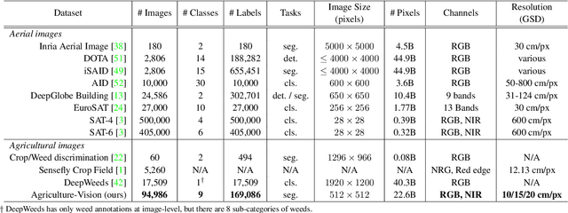


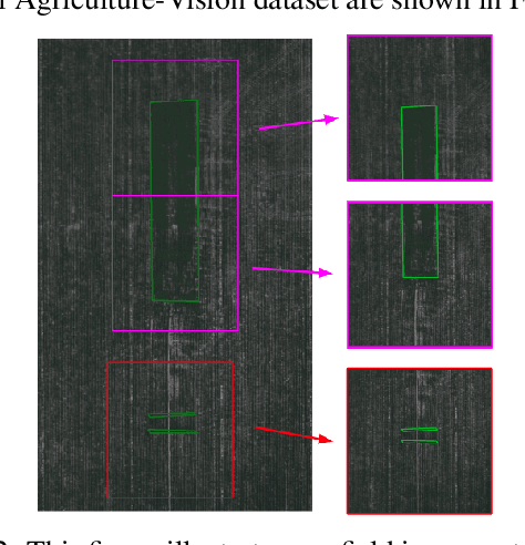
Abstract:The success of deep learning in visual recognition tasks has driven advancements in multiple fields of research. Particularly, increasing attention has been drawn towards its application in agriculture. Nevertheless, while visual pattern recognition on farmlands carries enormous economic values, little progress has been made to merge computer vision and crop sciences due to the lack of suitable agricultural image datasets. Meanwhile, problems in agriculture also pose new challenges in computer vision. For example, semantic segmentation of aerial farmland images requires inference over extremely large-size images with extreme annotation sparsity. These challenges are not present in most of the common object datasets, and we show that they are more challenging than many other aerial image datasets. To encourage research in computer vision for agriculture, we present Agriculture-Vision: a large-scale aerial farmland image dataset for semantic segmentation of agricultural patterns. We collected 94,986 high-quality aerial images from 3,432 farmlands across the US, where each image consists of RGB and Near-infrared (NIR) channels with resolution as high as 10 cm per pixel. We annotate nine types of field anomaly patterns that are most important to farmers. As a pilot study of aerial agricultural semantic segmentation, we perform comprehensive experiments using popular semantic segmentation models; we also propose an effective model designed for aerial agricultural pattern recognition. Our experiments demonstrate several challenges Agriculture-Vision poses to both the computer vision and agriculture communities. Future versions of this dataset will include even more aerial images, anomaly patterns and image channels. More information at https://www.agriculture-vision.com.
LADN: Local Adversarial Disentangling Network for Facial Makeup and De-Makeup
Apr 25, 2019


Abstract:We propose a local adversarial disentangling network (LADN) for facial makeup and de-makeup. Central to our method are multiple and overlapping local adversarial discriminators in a content-style disentangling network for achieving local detail transfer between facial images, with the use of asymmetric loss functions for dramatic makeup styles with high-frequency details. Existing techniques do not demonstrate or fail to transfer high-frequency details in a global adversarial setting, or train a single local discriminator only to ensure image structure consistency and thus work only for relatively simple styles. Unlike others, our proposed local adversarial discriminators can distinguish whether the generated local image details are consistent with the corresponding regions in the given reference image in cross-image style transfer in an unsupervised setting. Incorporating these technical contributions, we achieve not only state-of-the-art results on conventional styles but also novel results involving complex and dramatic styles with high-frequency details covering large areas across multiple facial features. A carefully designed dataset of unpaired before and after makeup images will be released.
 Add to Chrome
 Add to Firefox
 Add to Edge