Gongzhe Li
Rectification Reimagined: A Unified Mamba Model for Image Correction and Rectangling with Prompts
Dec 21, 2025


Abstract:Image correction and rectangling are valuable tasks in practical photography systems such as smartphones. Recent remarkable advancements in deep learning have undeniably brought about substantial performance improvements in these fields. Nevertheless, existing methods mainly rely on task-specific architectures. This significantly restricts their generalization ability and effective application across a wide range of different tasks. In this paper, we introduce the Unified Rectification Framework (UniRect), a comprehensive approach that addresses these practical tasks from a consistent distortion rectification perspective. Our approach incorporates various task-specific inverse problems into a general distortion model by simulating different types of lenses. To handle diverse distortions, UniRect adopts one task-agnostic rectification framework with a dual-component structure: a {Deformation Module}, which utilizes a novel Residual Progressive Thin-Plate Spline (RP-TPS) model to address complex geometric deformations, and a subsequent Restoration Module, which employs Residual Mamba Blocks (RMBs) to counteract the degradation caused by the deformation process and enhance the fidelity of the output image. Moreover, a Sparse Mixture-of-Experts (SMoEs) structure is designed to circumvent heavy task competition in multi-task learning due to varying distortions. Extensive experiments demonstrate that our models have achieved state-of-the-art performance compared with other up-to-date methods.
EGP3D: Edge-guided Geometric Preserving 3D Point Cloud Super-resolution for RGB-D camera
Dec 16, 2024


Abstract:Point clouds or depth images captured by current RGB-D cameras often suffer from low resolution, rendering them insufficient for applications such as 3D reconstruction and robots. Existing point cloud super-resolution (PCSR) methods are either constrained by geometric artifacts or lack attention to edge details. To address these issues, we propose an edge-guided geometric-preserving 3D point cloud super-resolution (EGP3D) method tailored for RGB-D cameras. Our approach innovatively optimizes the point cloud with an edge constraint on a projected 2D space, thereby ensuring high-quality edge preservation in the 3D PCSR task. To tackle geometric optimization challenges in super-resolution point clouds, particularly preserving edge shapes and smoothness, we introduce a multi-faceted loss function that simultaneously optimizes the Chamfer distance, Hausdorff distance, and gradient smoothness. Existing datasets used for point cloud upsampling are predominantly synthetic and inadequately represent real-world scenarios, neglecting noise and stray light effects. To address the scarcity of realistic RGB-D data for PCSR tasks, we built a dataset that captures real-world noise and stray-light effects, offering a more accurate representation of authentic environments. Validated through simulations and real-world experiments, the proposed method exhibited superior performance in preserving edge clarity and geometric details.
NTIRE 2021 Multi-modal Aerial View Object Classification Challenge
Jul 02, 2021


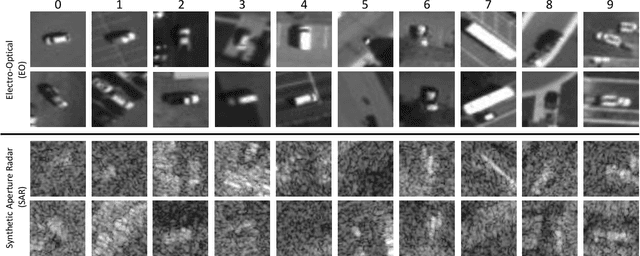
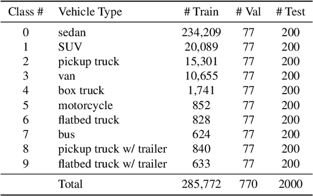
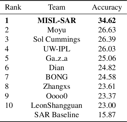
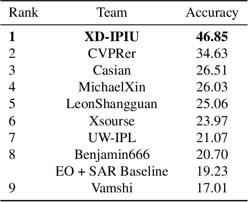
Abstract:In this paper, we introduce the first Challenge on Multi-modal Aerial View Object Classification (MAVOC) in conjunction with the NTIRE 2021 workshop at CVPR. This challenge is composed of two different tracks using EO andSAR imagery. Both EO and SAR sensors possess different advantages and drawbacks. The purpose of this competition is to analyze how to use both sets of sensory information in complementary ways. We discuss the top methods submitted for this competition and evaluate their results on our blind test set. Our challenge results show significant improvement of more than 15% accuracy from our current baselines for each track of the competition
* 10 pages, 1 figure. Conference on Computer Vision and Pattern Recognition
A novel three-stage training strategy for long-tailed classification
Apr 20, 2021

Abstract:The long-tailed distribution datasets poses great challenges for deep learning based classification models on how to handle the class imbalance problem. Existing solutions usually involve class-balacing strategies or transfer learing from head- to tail-classes or use two-stages learning strategy to re-train the classifier. However, the existing methods are difficult to solve the low quality problem when images are obtained by SAR. To address this problem, we establish a novel three-stages training strategy, which has excellent results for processing SAR image datasets with long-tailed distribution. Specifically, we divide training procedure into three stages. The first stage is to use all kinds of images for rough-training, so as to get the rough-training model with rich content. The second stage is to make the rough model learn the feature expression by using the residual dataset with the class 0 removed. The third stage is to fine tune the model using class-balanced datasets with all 10 classes (including the overall model fine tuning and classifier re-optimization). Through this new training strategy, we only use the information of SAR image dataset and the network model with very small parameters to achieve the top 1 accuracy of 22.34 in development phase.
 Add to Chrome
 Add to Firefox
 Add to Edge