Xiaodan Shi
AutoPV: Automatically Design Your Photovoltaic Power Forecasting Model
Aug 01, 2024Abstract:Photovoltaic power forecasting (PVPF) is a critical area in time series forecasting (TSF), enabling the efficient utilization of solar energy. With advancements in machine learning and deep learning, various models have been applied to PVPF tasks. However, constructing an optimal predictive architecture for specific PVPF tasks remains challenging, as it requires cross-domain knowledge and significant labor costs. To address this challenge, we introduce AutoPV, a novel framework for the automated search and construction of PVPF models based on neural architecture search (NAS) technology. We develop a brand new NAS search space that incorporates various data processing techniques from state-of-the-art (SOTA) TSF models and typical PVPF deep learning models. The effectiveness of AutoPV is evaluated on diverse PVPF tasks using a dataset from the Daqing Photovoltaic Station in China. Experimental results demonstrate that AutoPV can complete the predictive architecture construction process in a relatively short time, and the newly constructed architecture is superior to SOTA predefined models. This work bridges the gap in applying NAS to TSF problems, assisting non-experts and industries in automatically designing effective PVPF models.
A Phone-based Distributed Ambient Temperature Measurement System with An Efficient Label-free Automated Training Strategy
Apr 16, 2024


Abstract:Enhancing the energy efficiency of buildings significantly relies on monitoring indoor ambient temperature. The potential limitations of conventional temperature measurement techniques, together with the omnipresence of smartphones, have redirected researchers' attention towards the exploration of phone-based ambient temperature estimation technology. Nevertheless, numerous obstacles remain to be addressed in order to achieve a practical implementation of this technology. This study proposes a distributed phone-based ambient temperature estimation system which enables collaboration between multiple phones to accurately measure the ambient temperature in each small area of an indoor space. Besides, it offers a secure, efficient, and cost-effective training strategy to train a new estimation model for each newly added phone, eliminating the need for manual collection of labeled data. This innovative training strategy can yield a high-performing estimation model for a new phone with just 5 data points, requiring only a few iterations. Meanwhile, by crowdsourcing, our system automatically provides accurate inferred labels for all newly collected data. We also highlight the potential of integrating federated learning into our system to ensure privacy protection at the end of this study. We believe this study has the potential to advance the practical application of phone-based ambient temperature measurement, facilitating energy-saving efforts in buildings.
Multi-spatial Multi-temporal Air Quality Forecasting with Integrated Monitoring and Reanalysis Data
Dec 31, 2023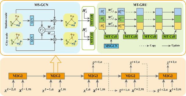

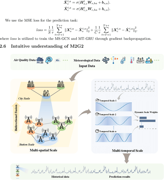
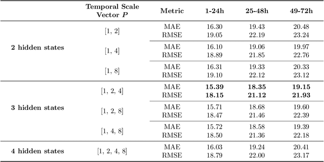
Abstract:Accurate air quality forecasting is crucial for public health, environmental monitoring and protection, and urban planning. However, existing methods fail to effectively utilize multi-scale information, both spatially and temporally. Spatially, there is a lack of integration between individual monitoring stations and city-wide scales. Temporally, the periodic nature of air quality variations is often overlooked or inadequately considered. To address these limitations, we present a novel Multi-spatial Multi-temporal air quality forecasting method based on Graph Convolutional Networks and Gated Recurrent Units (M2G2), bridging the gap in air quality forecasting across spatial and temporal scales. The proposed framework consists of two modules: Multi-scale Spatial GCN (MS-GCN) for spatial information fusion and Multi-scale Temporal GRU(MT-GRU) for temporal information integration. In the spatial dimension, the MS-GCN module employs a bidirectional learnable structure and a residual structure, enabling comprehensive information exchange between individual monitoring stations and the city-scale graph. Regarding the temporal dimension, the MT-GRU module adaptively combines information from different temporal scales through parallel hidden states. Leveraging meteorological indicators and four air quality indicators, we present comprehensive comparative analyses and ablation experiments, showcasing the higher accuracy of M2G2 in comparison to nine currently available advanced approaches across all aspects. The improvements of M2G2 over the second-best method on RMSE of the 24h/48h/72h are as follows: PM2.5: (7.72%, 6.67%, 10.45%); PM10: (6.43%, 5.68%, 7.73%); NO2: (5.07%, 7.76%, 16.60%); O3: (6.46%, 6.86%, 9.79%). Furthermore, we demonstrate the effectiveness of each module of M2G2 by ablation study.
Hybrid Feature Embedding For Automatic Building Outline Extraction
Jul 20, 2023
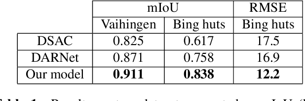


Abstract:Building outline extracted from high-resolution aerial images can be used in various application fields such as change detection and disaster assessment. However, traditional CNN model cannot recognize contours very precisely from original images. In this paper, we proposed a CNN and Transformer based model together with active contour model to deal with this problem. We also designed a triple-branch decoder structure to handle different features generated by encoder. Experiment results show that our model outperforms other baseline model on two datasets, achieving 91.1% mIoU on Vaihingen and 83.8% on Bing huts.
Enhancing Building Semantic Segmentation Accuracy with Super Resolution and Deep Learning: Investigating the Impact of Spatial Resolution on Various Datasets
Jul 09, 2023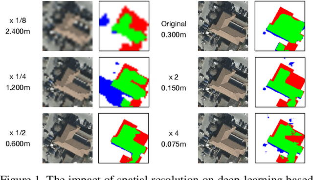
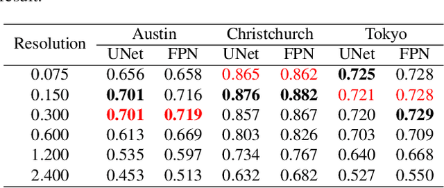
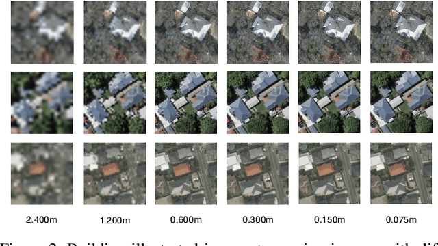
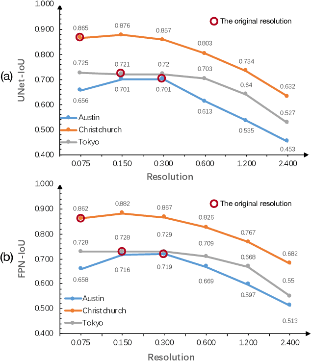
Abstract:The development of remote sensing and deep learning techniques has enabled building semantic segmentation with high accuracy and efficiency. Despite their success in different tasks, the discussions on the impact of spatial resolution on deep learning based building semantic segmentation are quite inadequate, which makes choosing a higher cost-effective data source a big challenge. To address the issue mentioned above, in this study, we create remote sensing images among three study areas into multiple spatial resolutions by super-resolution and down-sampling. After that, two representative deep learning architectures: UNet and FPN, are selected for model training and testing. The experimental results obtained from three cities with two deep learning models indicate that the spatial resolution greatly influences building segmentation results, and with a better cost-effectiveness around 0.3m, which we believe will be an important insight for data selection and preparation.
Real-World Video for Zoom Enhancement based on Spatio-Temporal Coupling
Jun 24, 2023


Abstract:In recent years, single-frame image super-resolution (SR) has become more realistic by considering the zooming effect and using real-world short- and long-focus image pairs. In this paper, we further investigate the feasibility of applying realistic multi-frame clips to enhance zoom quality via spatio-temporal information coupling. Specifically, we first built a real-world video benchmark, VideoRAW, by a synchronized co-axis optical system. The dataset contains paired short-focus raw and long-focus sRGB videos of different dynamic scenes. Based on VideoRAW, we then presented a Spatio-Temporal Coupling Loss, termed as STCL. The proposed STCL is intended for better utilization of information from paired and adjacent frames to align and fuse features both temporally and spatially at the feature level. The outperformed experimental results obtained in different zoom scenarios demonstrate the superiority of integrating real-world video dataset and STCL into existing SR models for zoom quality enhancement, and reveal that the proposed method can serve as an advanced and viable tool for video zoom.
Semantic Segmentation for Urban Planning Maps based on U-Net
Oct 01, 2018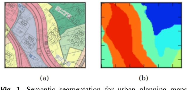
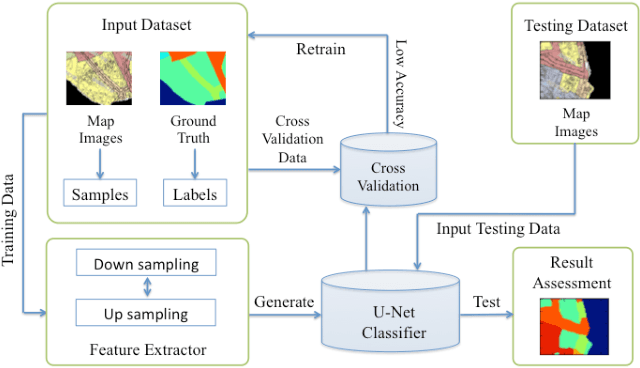
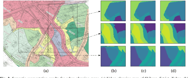
Abstract:The automatic digitizing of paper maps is a significant and challenging task for both academia and industry. As an important procedure of map digitizing, the semantic segmentation section mainly relies on manual visual interpretation with low efficiency. In this study, we select urban planning maps as a representative sample and investigate the feasibility of utilizing U-shape fully convolutional based architecture to perform end-to-end map semantic segmentation. The experimental results obtained from the test area in Shibuya district, Tokyo, demonstrate that our proposed method could achieve a very high Jaccard similarity coefficient of 93.63% and an overall accuracy of 99.36%. For implementation on GPGPU and cuDNN, the required processing time for the whole Shibuya district can be less than three minutes. The results indicate the proposed method can serve as a viable tool for urban planning map semantic segmentation task with high accuracy and efficiency.
 Add to Chrome
 Add to Firefox
 Add to Edge