Shraddha Singh
Fine-tuning of Geospatial Foundation Models for Aboveground Biomass Estimation
Jun 28, 2024


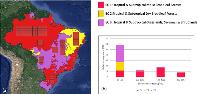
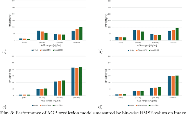
Abstract:Global vegetation structure mapping is critical for understanding the global carbon cycle and maximizing the efficacy of nature-based carbon sequestration initiatives. Moreover, vegetation structure mapping can help reduce the impacts of climate change by, for example, guiding actions to improve water security, increase biodiversity and reduce flood risk. Global satellite measurements provide an important set of observations for monitoring and managing deforestation and degradation of existing forests, natural forest regeneration, reforestation, biodiversity restoration, and the implementation of sustainable agricultural practices. In this paper, we explore the effectiveness of fine-tuning of a geospatial foundation model to estimate above-ground biomass (AGB) using space-borne data collected across different eco-regions in Brazil. The fine-tuned model architecture consisted of a Swin-B transformer as the encoder (i.e., backbone) and a single convolutional layer for the decoder head. All results were compared to a U-Net which was trained as the baseline model Experimental results of this sparse-label prediction task demonstrate that the fine-tuned geospatial foundation model with a frozen encoder has comparable performance to a U-Net trained from scratch. This is despite the fine-tuned model having 13 times less parameters requiring optimization, which saves both time and compute resources. Further, we explore the transfer-learning capabilities of the geospatial foundation models by fine-tuning on satellite imagery with sparse labels from different eco-regions in Brazil.
AI Foundation Models for Weather and Climate: Applications, Design, and Implementation
Sep 20, 2023Abstract:Machine learning and deep learning methods have been widely explored in understanding the chaotic behavior of the atmosphere and furthering weather forecasting. There has been increasing interest from technology companies, government institutions, and meteorological agencies in building digital twins of the Earth. Recent approaches using transformers, physics-informed machine learning, and graph neural networks have demonstrated state-of-the-art performance on relatively narrow spatiotemporal scales and specific tasks. With the recent success of generative artificial intelligence (AI) using pre-trained transformers for language modeling and vision with prompt engineering and fine-tuning, we are now moving towards generalizable AI. In particular, we are witnessing the rise of AI foundation models that can perform competitively on multiple domain-specific downstream tasks. Despite this progress, we are still in the nascent stages of a generalizable AI model for global Earth system models, regional climate models, and mesoscale weather models. Here, we review current state-of-the-art AI approaches, primarily from transformer and operator learning literature in the context of meteorology. We provide our perspective on criteria for success towards a family of foundation models for nowcasting and forecasting weather and climate predictions. We also discuss how such models can perform competitively on downstream tasks such as downscaling (super-resolution), identifying conditions conducive to the occurrence of wildfires, and predicting consequential meteorological phenomena across various spatiotemporal scales such as hurricanes and atmospheric rivers. In particular, we examine current AI methodologies and contend they have matured enough to design and implement a weather foundation model.
 Add to Chrome
 Add to Firefox
 Add to Edge