Samantha T. Arundel
GIScience in the Era of Artificial Intelligence: A Research Agenda Towards Autonomous GIS
Apr 01, 2025Abstract:The advent of generative AI exemplified by large language models (LLMs) opens new ways to represent and compute geographic information and transcend the process of geographic knowledge production, driving geographic information systems (GIS) towards autonomous GIS. Leveraging LLMs as the decision core, autonomous GIS can independently generate and execute geoprocessing workflows to perform spatial analysis. In this vision paper, we elaborate on the concept of autonomous GIS and present a framework that defines its five autonomous goals, five levels of autonomy, five core functions, and three operational scales. We demonstrate how autonomous GIS could perform geospatial data retrieval, spatial analysis, and map making with four proof-of-concept GIS agents. We conclude by identifying critical challenges and future research directions, including fine-tuning and self-growing decision cores, autonomous modeling, and examining the ethical and practical implications of autonomous GIS. By establishing the groundwork for a paradigm shift in GIScience, this paper envisions a future where GIS moves beyond traditional workflows to autonomously reason, derive, innovate, and advance solutions to pressing global challenges.
Segment Anything Model Can Not Segment Anything: Assessing AI Foundation Model's Generalizability in Permafrost Mapping
Jan 16, 2024
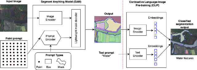

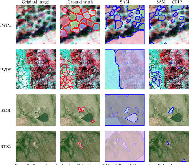
Abstract:This paper assesses trending AI foundation models, especially emerging computer vision foundation models and their performance in natural landscape feature segmentation. While the term foundation model has quickly garnered interest from the geospatial domain, its definition remains vague. Hence, this paper will first introduce AI foundation models and their defining characteristics. Built upon the tremendous success achieved by Large Language Models (LLMs) as the foundation models for language tasks, this paper discusses the challenges of building foundation models for geospatial artificial intelligence (GeoAI) vision tasks. To evaluate the performance of large AI vision models, especially Meta's Segment Anything Model (SAM), we implemented different instance segmentation pipelines that minimize the changes to SAM to leverage its power as a foundation model. A series of prompt strategies was developed to test SAM's performance regarding its theoretical upper bound of predictive accuracy, zero-shot performance, and domain adaptability through fine-tuning. The analysis used two permafrost feature datasets, ice-wedge polygons and retrogressive thaw slumps because (1) these landform features are more challenging to segment than manmade features due to their complicated formation mechanisms, diverse forms, and vague boundaries; (2) their presence and changes are important indicators for Arctic warming and climate change. The results show that although promising, SAM still has room for improvement to support AI-augmented terrain mapping. The spatial and domain generalizability of this finding is further validated using a more general dataset EuroCrop for agricultural field mapping. Finally, we discuss future research directions that strengthen SAM's applicability in challenging geospatial domains.
Assessment of IBM and NASA's geospatial foundation model in flood inundation mapping
Sep 25, 2023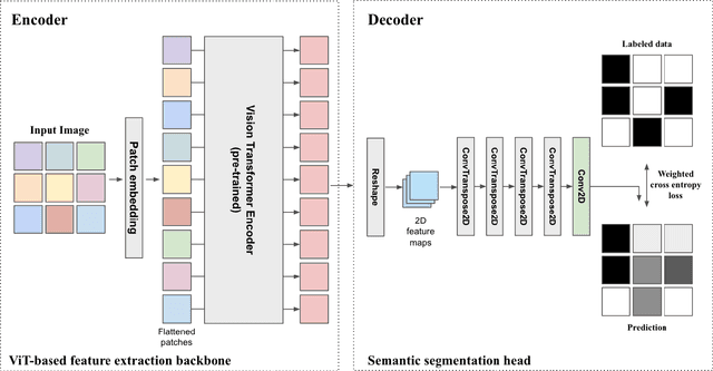
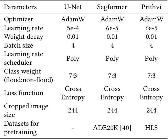
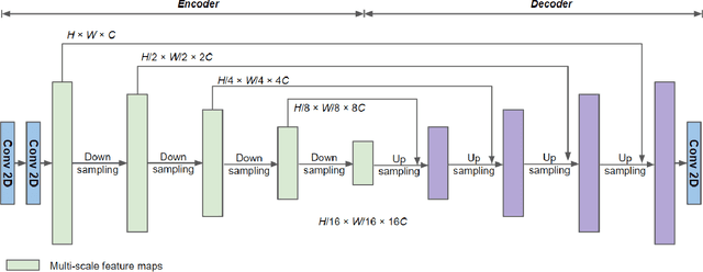

Abstract:Vision foundation models are a new frontier in GeoAI research because of their potential to enable powerful image analysis by learning and extracting important image features from vast amounts of geospatial data. This paper evaluates the performance of the first-of-its-kind geospatial foundation model, IBM-NASA's Prithvi, to support a crucial geospatial analysis task: flood inundation mapping. This model is compared with popular convolutional neural network and vision transformer-based architectures in terms of mapping accuracy for flooded areas. A benchmark dataset, Sen1Floods11, is used in the experiments, and the models' predictability, generalizability, and transferability are evaluated based on both a test dataset and a dataset that is completely unseen by the model. Results show the impressive transferability of the Prithvi model, highlighting its performance advantages in segmenting flooded areas in previously unseen regions. The findings also suggest areas for improvement for the Prithvi model in terms of adopting multi-scale representation learning, developing more end-to-end pipelines for high-level image analysis tasks, and offering more flexibility in terms of input data bands.
Deep Convolutional Neural Networks for Map-Type Classification
May 26, 2018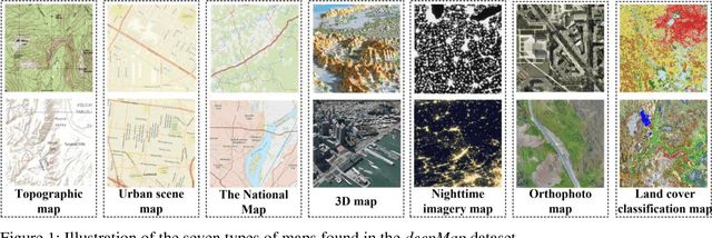
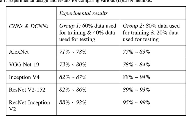

Abstract:Maps are an important medium that enable people to comprehensively understand the configuration of cultural activities and natural elements over different times and places. Although massive maps are available in the digital era, how to effectively and accurately access the required map remains a challenge today. Previous works partially related to map-type classification mainly focused on map comparison and map matching at the local scale. The features derived from local map areas might be insufficient to characterize map content. To facilitate establishing an automatic approach for accessing the needed map, this paper reports our investigation into using deep learning techniques to recognize seven types of map, including topographic map, terrain map, physical map, urban scene map, the National Map, 3D map, nighttime map, orthophoto map, and land cover classification map. Experimental results show that the state-of-the-art deep convolutional neural networks can support automatic map-type classification. Additionally, the classification accuracy varies according to different map-types. We hope our work can contribute to the implementation of deep learning techniques in cartographical community and advance the progress of Geographical Artificial Intelligence (GeoAI).
 Add to Chrome
 Add to Firefox
 Add to Edge