Xiran Zhou
A2CI: A Cloud-based, Service-oriented Geospatial Cyberinfrastructure to Support Atmospheric Research
Mar 15, 2024Abstract:Big earth science data offers the scientific community great opportunities. Many more studies at large-scales, over long-terms and at high resolution can now be conducted using the rich information collected by remote sensing satellites, ground-based sensor networks, and even social media input. However, the hundreds of terabytes of information collected and compiled on an hourly basis by NASA and other government agencies present a significant challenge for atmospheric scientists seeking to improve the understanding of the Earth atmospheric system. These challenges include effective discovery, organization, analysis and visualization of large amounts of data. This paper reports the outcomes of an NSF-funded project that developed a geospatial cyberinfrastructure -- the A2CI (Atmospheric Analysis Cyberinfrastructure) -- to support atmospheric research. We first introduce the service-oriented system framework then describe in detail the implementation of the data discovery module, data management module, data integration module, data analysis and visualization modules following the cloud computing principles-Data-as-a-Service, Software-as-a-Service, Platform-as-a-Service and Infrastructure-as-a-Service. We demonstrate the graphic user interface by performing an analysis between Sea Surface Temperature and the intensity of tropical storms in the North Atlantic and Pacific oceans. We expect this work to contribute to the technical advancement of cyberinfrastructure research as well as to the development of an online, collaborative scientific analysis system for atmospheric science.
CartoMark: a benchmark dataset for map pattern recognition and 1 map content retrieval with machine intelligence
Dec 14, 2023


Abstract:Maps are fundamental medium to visualize and represent the real word in a simple and 16 philosophical way. The emergence of the 3rd wave information has made a proportion of maps are available to be generated ubiquitously, which would significantly enrich the dimensions and perspectives to understand the characteristics of the real world. However, a majority of map dataset have never been discovered, acquired and effectively used, and the map data used in many applications might not be completely fitted for the authentic demands of these applications. This challenge is emerged due to the lack of numerous well-labelled benchmark datasets for implementing the deep learning approaches into identifying complicated map content. Thus, we develop a large-scale benchmark dataset that includes well-labelled dataset for map text annotation recognition, map scene classification, map super-resolution reconstruction, and map style transferring. Furthermore, these well-labelled datasets would facilitate the state-of-the-art machine intelligence technologies to conduct map feature detection, map pattern recognition and map content retrieval. We hope our efforts would be useful for AI-enhanced cartographical applications.
Deep Convolutional Neural Networks for Map-Type Classification
May 26, 2018


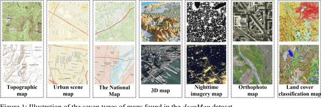
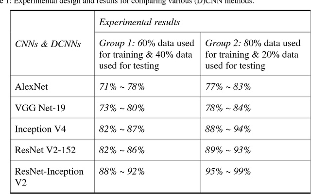
Abstract:Maps are an important medium that enable people to comprehensively understand the configuration of cultural activities and natural elements over different times and places. Although massive maps are available in the digital era, how to effectively and accurately access the required map remains a challenge today. Previous works partially related to map-type classification mainly focused on map comparison and map matching at the local scale. The features derived from local map areas might be insufficient to characterize map content. To facilitate establishing an automatic approach for accessing the needed map, this paper reports our investigation into using deep learning techniques to recognize seven types of map, including topographic map, terrain map, physical map, urban scene map, the National Map, 3D map, nighttime map, orthophoto map, and land cover classification map. Experimental results show that the state-of-the-art deep convolutional neural networks can support automatic map-type classification. Additionally, the classification accuracy varies according to different map-types. We hope our work can contribute to the implementation of deep learning techniques in cartographical community and advance the progress of Geographical Artificial Intelligence (GeoAI).
 Add to Chrome
 Add to Firefox
 Add to Edge