Pierre Bonnet
Compact Hypercube Embeddings for Fast Text-based Wildlife Observation Retrieval
Jan 30, 2026Abstract:Large-scale biodiversity monitoring platforms increasingly rely on multimodal wildlife observations. While recent foundation models enable rich semantic representations across vision, audio, and language, retrieving relevant observations from massive archives remains challenging due to the computational cost of high-dimensional similarity search. In this work, we introduce compact hypercube embeddings for fast text-based wildlife observation retrieval, a framework that enables efficient text-based search over large-scale wildlife image and audio databases using compact binary representations. Building on the cross-view code alignment hashing framework, we extend lightweight hashing beyond a single-modality setup to align natural language descriptions with visual or acoustic observations in a shared Hamming space. Our approach leverages pretrained wildlife foundation models, including BioCLIP and BioLingual, and adapts them efficiently for hashing using parameter-efficient fine-tuning. We evaluate our method on large-scale benchmarks, including iNaturalist2024 for text-to-image retrieval and iNatSounds2024 for text-to-audio retrieval, as well as multiple soundscape datasets to assess robustness under domain shift. Results show that retrieval using discrete hypercube embeddings achieves competitive, and in several cases superior, performance compared to continuous embeddings, while drastically reducing memory and search cost. Moreover, we observe that the hashing objective consistently improves the underlying encoder representations, leading to stronger retrieval and zero-shot generalization. These results demonstrate that binary, language-based retrieval enables scalable and efficient search over large wildlife archives for biodiversity monitoring systems.
GeoPl@ntNet: A Platform for Exploring Essential Biodiversity Variables
Nov 16, 2025Abstract:This paper describes GeoPl@ntNet, an interactive web application designed to make Essential Biodiversity Variables accessible and understandable to everyone through dynamic maps and fact sheets. Its core purpose is to allow users to explore high-resolution AI-generated maps of species distributions, habitat types, and biodiversity indicators across Europe. These maps, developed through a cascading pipeline involving convolutional neural networks and large language models, provide an intuitive yet information-rich interface to better understand biodiversity, with resolutions as precise as 50x50 meters. The website also enables exploration of specific regions, allowing users to select areas of interest on the map (e.g., urban green spaces, protected areas, or riverbanks) to view local species and their coverage. Additionally, GeoPl@ntNet generates comprehensive reports for selected regions, including insights into the number of protected species, invasive species, and endemic species.
Overview of PlantCLEF 2024: multi-species plant identification in vegetation plot images
Sep 19, 2025


Abstract:Plot images are essential for ecological studies, enabling standardized sampling, biodiversity assessment, long-term monitoring and remote, large-scale surveys. Plot images are typically fifty centimetres or one square meter in size, and botanists meticulously identify all the species found there. The integration of AI could significantly improve the efficiency of specialists, helping them to extend the scope and coverage of ecological studies. To evaluate advances in this regard, the PlantCLEF 2024 challenge leverages a new test set of thousands of multi-label images annotated by experts and covering over 800 species. In addition, it provides a large training set of 1.7 million individual plant images as well as state-of-the-art vision transformer models pre-trained on this data. The task is evaluated as a (weakly-labeled) multi-label classification task where the aim is to predict all the plant species present on a high-resolution plot image (using the single-label training data). In this paper, we provide an detailed description of the data, the evaluation methodology, the methods and models employed by the participants and the results achieved.
Mapping biodiversity at very-high resolution in Europe
Apr 07, 2025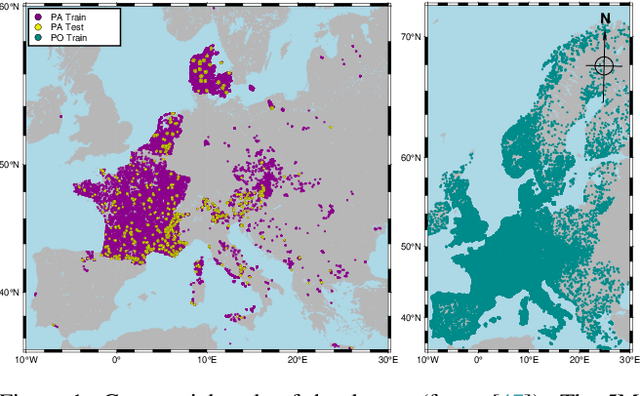


Abstract:This paper describes a cascading multimodal pipeline for high-resolution biodiversity mapping across Europe, integrating species distribution modeling, biodiversity indicators, and habitat classification. The proposed pipeline first predicts species compositions using a deep-SDM, a multimodal model trained on remote sensing, climate time series, and species occurrence data at 50x50m resolution. These predictions are then used to generate biodiversity indicator maps and classify habitats with Pl@ntBERT, a transformer-based LLM designed for species-to-habitat mapping. With this approach, continental-scale species distribution maps, biodiversity indicator maps, and habitat maps are produced, providing fine-grained ecological insights. Unlike traditional methods, this framework enables joint modeling of interspecies dependencies, bias-aware training with heterogeneous presence-absence data, and large-scale inference from multi-source remote sensing inputs.
Applying the maximum entropy principle to multi-species neural networks improves species distribution models
Dec 26, 2024


Abstract:The rapid expansion of citizen science initiatives has led to a significant growth of biodiversity databases, and particularly presence-only (PO) observations. PO data are invaluable for understanding species distributions and their dynamics, but their use in Species Distribution Models (SDM) is curtailed by sampling biases and the lack of information on absences. Poisson point processes are widely used for SDMs, with Maxent being one of the most popular methods. Maxent maximises the entropy of a probability distribution across sites as a function of predefined transformations of environmental variables, called features. In contrast, neural networks and deep learning have emerged as a promising technique for automatic feature extraction from complex input variables. In this paper, we propose DeepMaxent, which harnesses neural networks to automatically learn shared features among species, using the maximum entropy principle. To do so, it employs a normalised Poisson loss where for each species, presence probabilities across sites are modelled by a neural network. We evaluate DeepMaxent on a benchmark dataset known for its spatial sampling biases, using PO data for calibration and presence-absence (PA) data for validation across six regions with different biological groups and environmental covariates. Our results indicate that DeepMaxent improves model performance over Maxent and other state-of-the-art SDMs across regions and taxonomic groups. The method performs particularly well in regions of uneven sampling, demonstrating substantial potential to improve species distribution modelling. The method opens the possibility to learn more robust environmental features predicting jointly many species and scales to arbitrary large numbers of sites without an increased memory demand.
GeoPlant: Spatial Plant Species Prediction Dataset
Aug 25, 2024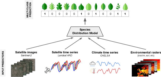
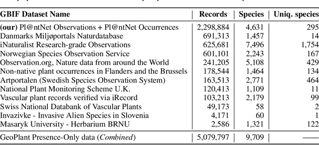
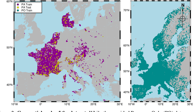

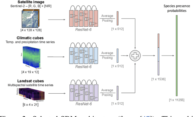
Abstract:The difficulty of monitoring biodiversity at fine scales and over large areas limits ecological knowledge and conservation efforts. To fill this gap, Species Distribution Models (SDMs) predict species across space from spatially explicit features. Yet, they face the challenge of integrating the rich but heterogeneous data made available over the past decade, notably millions of opportunistic species observations and standardized surveys, as well as multi-modal remote sensing data. In light of that, we have designed and developed a new European-scale dataset for SDMs at high spatial resolution (10-50 m), including more than 10k species (i.e., most of the European flora). The dataset comprises 5M heterogeneous Presence-Only records and 90k exhaustive Presence-Absence survey records, all accompanied by diverse environmental rasters (e.g., elevation, human footprint, and soil) that are traditionally used in SDMs. In addition, it provides Sentinel-2 RGB and NIR satellite images with 10 m resolution, a 20-year time-series of climatic variables, and satellite time-series from the Landsat program. In addition to the data, we provide an openly accessible SDM benchmark (hosted on Kaggle), which has already attracted an active community and a set of strong baselines for single predictor/modality and multimodal approaches. All resources, e.g., the dataset, pre-trained models, and baseline methods (in the form of notebooks), are available on Kaggle, allowing one to start with our dataset literally with two mouse clicks.
Cooperative learning of Pl@ntNet's Artificial Intelligence algorithm: how does it work and how can we improve it?
Jun 05, 2024Abstract:Deep learning models for plant species identification rely on large annotated datasets. The PlantNet system enables global data collection by allowing users to upload and annotate plant observations, leading to noisy labels due to diverse user skills. Achieving consensus is crucial for training, but the vast scale of collected data makes traditional label aggregation strategies challenging. Existing methods either retain all observations, resulting in noisy training data or selectively keep those with sufficient votes, discarding valuable information. Additionally, as many species are rarely observed, user expertise can not be evaluated as an inter-user agreement: otherwise, botanical experts would have a lower weight in the AI training step than the average user. Our proposed label aggregation strategy aims to cooperatively train plant identification AI models. This strategy estimates user expertise as a trust score per user based on their ability to identify plant species from crowdsourced data. The trust score is recursively estimated from correctly identified species given the current estimated labels. This interpretable score exploits botanical experts' knowledge and the heterogeneity of users. Subsequently, our strategy removes unreliable observations but retains those with limited trusted annotations, unlike other approaches. We evaluate PlantNet's strategy on a released large subset of the PlantNet database focused on European flora, comprising over 6M observations and 800K users. We demonstrate that estimating users' skills based on the diversity of their expertise enhances labeling performance. Our findings emphasize the synergy of human annotation and data filtering in improving AI performance for a refined dataset. We explore incorporating AI-based votes alongside human input. This can further enhance human-AI interactions to detect unreliable observations.
Modelling Species Distributions with Deep Learning to Predict Plant Extinction Risk and Assess Climate Change Impacts
Jan 10, 2024Abstract:The post-2020 global biodiversity framework needs ambitious, research-based targets. Estimating the accelerated extinction risk due to climate change is critical. The International Union for Conservation of Nature (IUCN) measures the extinction risk of species. Automatic methods have been developed to provide information on the IUCN status of under-assessed taxa. However, these compensatory methods are based on current species characteristics, mainly geographical, which precludes their use in future projections. Here, we evaluate a novel method for classifying the IUCN status of species benefiting from the generalisation power of species distribution models based on deep learning. Our method matches state-of-the-art classification performance while relying on flexible SDM-based features that capture species' environmental preferences. Cross-validation yields average accuracies of 0.61 for status classification and 0.78 for binary classification. Climate change will reshape future species distributions. Under the species-environment equilibrium hypothesis, SDM projections approximate plausible future outcomes. Two extremes of species dispersal capacity are considered: unlimited or null. The projected species distributions are translated into features feeding our IUCN classification method. Finally, trends in threatened species are analysed over time and i) by continent and as a function of average ii) latitude or iii) altitude. The proportion of threatened species is increasing globally, with critical rates in Africa, Asia and South America. Furthermore, the proportion of threatened species is predicted to peak around the two Tropics, at the Equator, in the lowlands and at altitudes of 800-1,500 m.
AI-based Mapping of the Conservation Status of Orchid Assemblages at Global Scale
Jan 09, 2024Abstract:Although increasing threats on biodiversity are now widely recognised, there are no accurate global maps showing whether and where species assemblages are at risk. We hereby assess and map at kilometre resolution the conservation status of the iconic orchid family, and discuss the insights conveyed at multiple scales. We introduce a new Deep Species Distribution Model trained on 1M occurrences of 14K orchid species to predict their assemblages at global scale and at kilometre resolution. We propose two main indicators of the conservation status of the assemblages: (i) the proportion of threatened species, and (ii) the status of the most threatened species in the assemblage. We show and analyze the variation of these indicators at World scale and in relation to currently protected areas in Sumatra island. Global and interactive maps available online show the indicators of conservation status of orchid assemblages, with sharp spatial variations at all scales. The highest level of threat is found at Madagascar and the neighbouring islands. In Sumatra, we found good correspondence of protected areas with our indicators, but supplementing current IUCN assessments with status predictions results in alarming levels of species threat across the island. Recent advances in deep learning enable reliable mapping of the conservation status of species assemblages on a global scale. As an umbrella taxon, orchid family provides a reference for identifying vulnerable ecosystems worldwide, and prioritising conservation actions both at international and local levels.
The GeoLifeCLEF 2020 Dataset
Apr 08, 2020
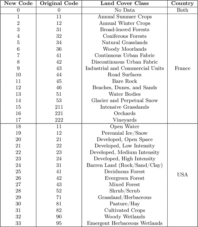
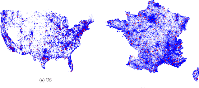
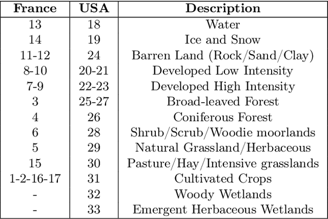
Abstract:Understanding the geographic distribution of species is a key concern in conservation. By pairing species occurrences with environmental features, researchers can model the relationship between an environment and the species which may be found there. To facilitate research in this area, we present the GeoLifeCLEF 2020 dataset, which consists of 1.9 million species observations paired with high-resolution remote sensing imagery, land cover data, and altitude, in addition to traditional low-resolution climate and soil variables. We also discuss the GeoLifeCLEF 2020 competition, which aims to use this dataset to advance the state-of-the-art in location-based species recommendation.
 Add to Chrome
 Add to Firefox
 Add to Edge