Markus Enzweiler
STREAM-VAE: Dual-Path Routing for Slow and Fast Dynamics in Vehicle Telemetry Anomaly Detection
Nov 19, 2025Abstract:Automotive telemetry data exhibits slow drifts and fast spikes, often within the same sequence, making reliable anomaly detection challenging. Standard reconstruction-based methods, including sequence variational autoencoders (VAEs), use a single latent process and therefore mix heterogeneous time scales, which can smooth out spikes or inflate variances and weaken anomaly separation. In this paper, we present STREAM-VAE, a variational autoencoder for anomaly detection in automotive telemetry time-series data. Our model uses a dual-path encoder to separate slow drift and fast spike signal dynamics, and a decoder that represents transient deviations separately from the normal operating pattern. STREAM-VAE is designed for deployment, producing stable anomaly scores across operating modes for both in-vehicle monitors and backend fleet analytics. Experiments on an automotive telemetry dataset and the public SMD benchmark show that explicitly separating drift and spike dynamics improves robustness compared to strong forecasting, attention, graph, and VAE baselines.
Enhancing LLM-based Autonomous Driving with Modular Traffic Light and Sign Recognition
Nov 18, 2025Abstract:Large Language Models (LLMs) are increasingly used for decision-making and planning in autonomous driving, showing promising reasoning capabilities and potential to generalize across diverse traffic situations. However, current LLM-based driving agents lack explicit mechanisms to enforce traffic rules and often struggle to reliably detect small, safety-critical objects such as traffic lights and signs. To address this limitation, we introduce TLS-Assist, a modular redundancy layer that augments LLM-based autonomous driving agents with explicit traffic light and sign recognition. TLS-Assist converts detections into structured natural language messages that are injected into the LLM input, enforcing explicit attention to safety-critical cues. The framework is plug-and-play, model-agnostic, and supports both single-view and multi-view camera setups. We evaluate TLS-Assist in a closed-loop setup on the LangAuto benchmark in CARLA. The results demonstrate relative driving performance improvements of up to 14% over LMDrive and 7% over BEVDriver, while consistently reducing traffic light and sign infractions. We publicly release the code and models on https://github.com/iis-esslingen/TLS-Assist.
GraphPilot: Grounded Scene Graph Conditioning for Language-Based Autonomous Driving
Nov 14, 2025Abstract:Vision-language models have recently emerged as promising planners for autonomous driving, where success hinges on topology-aware reasoning over spatial structure and dynamic interactions from multimodal input. However, existing models are typically trained without supervision that explicitly encodes these relational dependencies, limiting their ability to infer how agents and other traffic entities influence one another from raw sensor data. In this work, we bridge this gap with a novel model-agnostic method that conditions language-based driving models on structured relational context in the form of traffic scene graphs. We serialize scene graphs at various abstraction levels and formats, and incorporate them into the models via structured prompt templates, enabling a systematic analysis of when and how relational supervision is most beneficial. Extensive evaluations on the public LangAuto benchmark show that scene graph conditioning of state-of-the-art approaches yields large and persistent improvement in driving performance. Notably, we observe up to a 15.6\% increase in driving score for LMDrive and 17.5\% for BEVDriver, indicating that models can better internalize and ground relational priors through scene graph-conditioned training, even without requiring scene graph input at test-time. Code, fine-tuned models, and our scene graph dataset are publicly available at https://github.com/iis-esslingen/GraphPilot.
Integration of Visual SLAM into Consumer-Grade Automotive Localization
Nov 10, 2025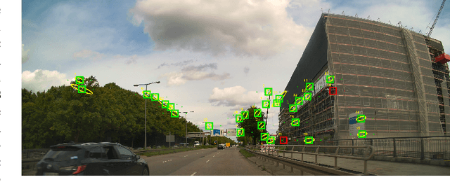


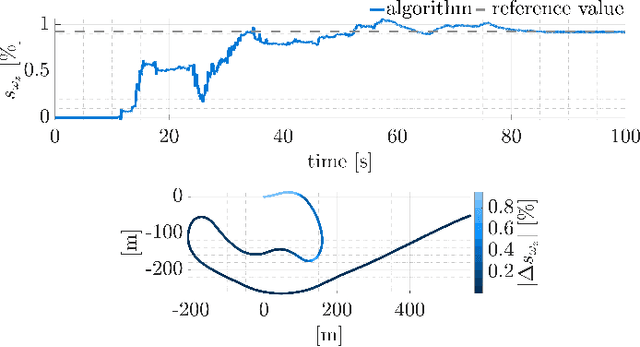
Abstract:Accurate ego-motion estimation in consumer-grade vehicles currently relies on proprioceptive sensors, i.e. wheel odometry and IMUs, whose performance is limited by systematic errors and calibration. While visual-inertial SLAM has become a standard in robotics, its integration into automotive ego-motion estimation remains largely unexplored. This paper investigates how visual SLAM can be integrated into consumer-grade vehicle localization systems to improve performance. We propose a framework that fuses visual SLAM with a lateral vehicle dynamics model to achieve online gyroscope calibration under realistic driving conditions. Experimental results demonstrate that vision-based integration significantly improves gyroscope calibration accuracy and thus enhances overall localization performance, highlighting a promising path toward higher automotive localization accuracy. We provide results on both proprietary and public datasets, showing improved performance and superior localization accuracy on a public benchmark compared to state-of-the-art methods.
Robust Radar SLAM for Vehicle Parking Applications
Sep 10, 2025Abstract:We address ego-motion estimation for automated parking, where centimeter-level accuracy is crucial due to tight spaces and nearby obstacles. Traditional methods using inertial-measurement units and wheel encoders require calibration, making them costly and time-consuming. To overcome this, we propose a radar-based simultaneous localization and mapping (SLAM) approach that leverages the robustness of radar to adverse weather and support for online calibration. Our robocentric formulation fuses feature positions and Doppler velocities for robust data association and filter convergence. Key contributions include a Doppler-augmented radar SLAM method, multi-radar support and an information-based feature-pruning strategy. Experiments demonstrate high-accuracy localization and improved robustness over state-of-the-art methods, meeting the demands of automated parking.
A Systematic Literature Review on Detecting Software Vulnerabilities with Large Language Models
Jul 30, 2025Abstract:The increasing adoption of Large Language Models (LLMs) in software engineering has sparked interest in their use for software vulnerability detection. However, the rapid development of this field has resulted in a fragmented research landscape, with diverse studies that are difficult to compare due to differences in, e.g., system designs and dataset usage. This fragmentation makes it difficult to obtain a clear overview of the state-of-the-art or compare and categorize studies meaningfully. In this work, we present a comprehensive systematic literature review (SLR) of LLM-based software vulnerability detection. We analyze 227 studies published between January 2020 and June 2025, categorizing them by task formulation, input representation, system architecture, and adaptation techniques. Further, we analyze the datasets used, including their characteristics, vulnerability coverage, and diversity. We present a fine-grained taxonomy of vulnerability detection approaches, identify key limitations, and outline actionable future research opportunities. By providing a structured overview of the field, this review improves transparency and serves as a practical guide for researchers and practitioners aiming to conduct more comparable and reproducible research. We publicly release all artifacts and maintain a living repository of LLM-based software vulnerability detection studies.
StixelNExT++: Lightweight Monocular Scene Segmentation and Representation for Collective Perception
Jul 09, 2025Abstract:This paper presents StixelNExT++, a novel approach to scene representation for monocular perception systems. Building on the established Stixel representation, our method infers 3D Stixels and enhances object segmentation by clustering smaller 3D Stixel units. The approach achieves high compression of scene information while remaining adaptable to point cloud and bird's-eye-view representations. Our lightweight neural network, trained on automatically generated LiDAR-based ground truth, achieves real-time performance with computation times as low as 10 ms per frame. Experimental results on the Waymo dataset demonstrate competitive performance within a 30-meter range, highlighting the potential of StixelNExT++ for collective perception in autonomous systems.
Data-Driven Object Tracking: Integrating Modular Neural Networks into a Kalman Framework
Apr 03, 2025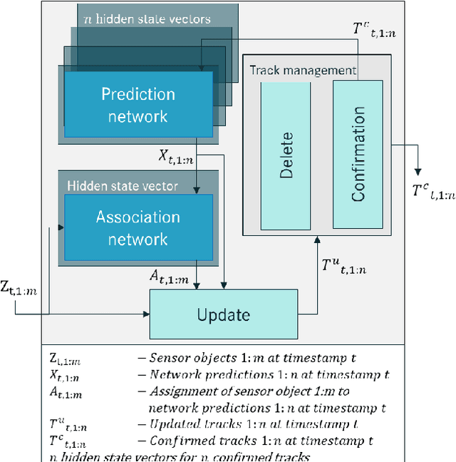
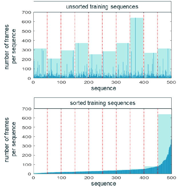
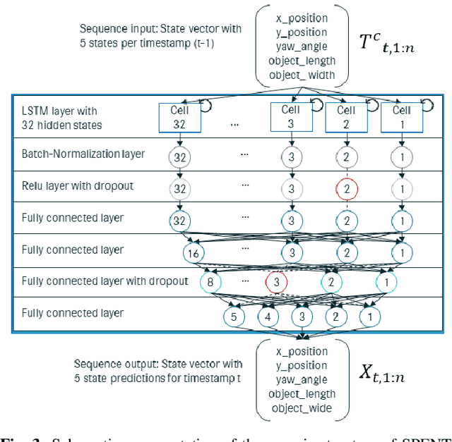
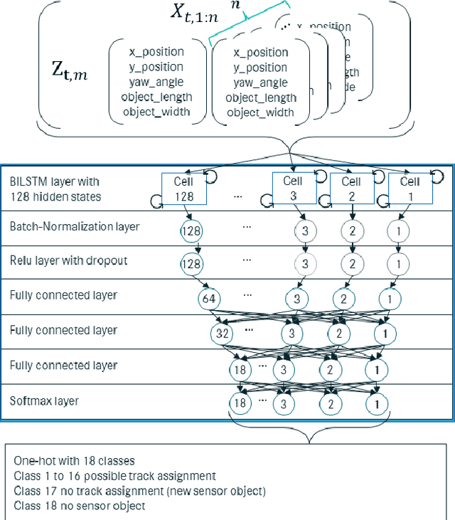
Abstract:This paper presents novel Machine Learning (ML) methodologies for Multi-Object Tracking (MOT), specifically designed to meet the increasing complexity and precision demands of Advanced Driver Assistance Systems (ADAS). We introduce three Neural Network (NN) models that address key challenges in MOT: (i) the Single-Prediction Network (SPENT) for trajectory prediction, (ii) the Single-Association Network (SANT) for mapping individual Sensor Object (SO) to existing tracks, and (iii) the Multi-Association Network (MANTa) for associating multiple SOs to multiple tracks. These models are seamlessly integrated into a traditional Kalman Filter (KF) framework, maintaining the system's modularity by replacing relevant components without disrupting the overall architecture. Importantly, all three networks are designed to be run in a realtime, embedded environment. Each network contains less than 50k trainable parameters. Our evaluation, conducted on the public KITTI tracking dataset, demonstrates significant improvements in tracking performance. SPENT reduces the Root Mean Square Error (RMSE) by 50% compared to a standard KF, while SANT and MANTa achieve up to 95% accuracy in sensor object-to-track assignments. These results underscore the effectiveness of incorporating task-specific NNs into traditional tracking systems, boosting performance and robustness while preserving modularity, maintainability, and interpretability.
NeRF and Gaussian Splatting SLAM in the Wild
Dec 04, 2024Abstract:Navigating outdoor environments with visual Simultaneous Localization and Mapping (SLAM) systems poses significant challenges due to dynamic scenes, lighting variations, and seasonal changes, requiring robust solutions. While traditional SLAM methods struggle with adaptability, deep learning-based approaches and emerging neural radiance fields as well as Gaussian Splatting-based SLAM methods, offer promising alternatives. However, these methods have primarily been evaluated in controlled indoor environments with stable conditions, leaving a gap in understanding their performance in unstructured and variable outdoor settings. This study addresses this gap by evaluating these methods in natural outdoor environments, focusing on camera tracking accuracy, robustness to environmental factors, and computational efficiency, highlighting distinct trade-offs. Extensive evaluations demonstrate that neural SLAM methods achieve superior robustness, particularly under challenging conditions such as low light, but at a high computational cost. At the same time, traditional methods perform the best across seasons but are highly sensitive to variations in lighting conditions. The code of the benchmark is publicly available at https://github.com/iis-esslingen/nerf-3dgs-benchmark.
ROVER: A Multi-Season Dataset for Visual SLAM
Dec 03, 2024Abstract:Robust Simultaneous Localization and Mapping (SLAM) is a crucial enabler for autonomous navigation in natural, unstructured environments such as parks and gardens. However, these environments present unique challenges for SLAM due to frequent seasonal changes, varying light conditions, and dense vegetation. These factors often degrade the performance of visual SLAM algorithms originally developed for structured urban environments. To address this gap, we present ROVER, a comprehensive benchmark dataset tailored for evaluating visual SLAM algorithms under diverse environmental conditions and spatial configurations. We captured the dataset with a robotic platform equipped with monocular, stereo, and RGB-D cameras, as well as inertial sensors. It covers 39 recordings across five outdoor locations, collected through all seasons and various lighting scenarios, i.e., day, dusk, and night with and without external lighting. With this novel dataset, we evaluate several traditional and deep learning-based SLAM methods and study their performance in diverse challenging conditions. The results demonstrate that while stereo-inertial and RGB-D configurations generally perform better under favorable lighting and moderate vegetation, most SLAM systems perform poorly in low-light and high-vegetation scenarios, particularly during summer and autumn. Our analysis highlights the need for improved adaptability in visual SLAM algorithms for outdoor applications, as current systems struggle with dynamic environmental factors affecting scale, feature extraction, and trajectory consistency. This dataset provides a solid foundation for advancing visual SLAM research in real-world, natural environments, fostering the development of more resilient SLAM systems for long-term outdoor localization and mapping. The dataset and the code of the benchmark are available under https://iis-esslingen.github.io/rover.
 Add to Chrome
 Add to Firefox
 Add to Edge