François Pomerleau
SilvaScenes: Tree Segmentation and Species Classification from Under-Canopy Images in Natural Forests
Oct 10, 2025Abstract:Interest in robotics for forest management is growing, but perception in complex, natural environments remains a significant hurdle. Conditions such as heavy occlusion, variable lighting, and dense vegetation pose challenges to automated systems, which are essential for precision forestry, biodiversity monitoring, and the automation of forestry equipment. These tasks rely on advanced perceptual capabilities, such as detection and fine-grained species classification of individual trees. Yet, existing datasets are inadequate to develop such perception systems, as they often focus on urban settings or a limited number of species. To address this, we present SilvaScenes, a new dataset for instance segmentation of tree species from under-canopy images. Collected across five bioclimatic domains in Quebec, Canada, SilvaScenes features 1476 trees from 24 species with annotations from forestry experts. We demonstrate the relevance and challenging nature of our dataset by benchmarking modern deep learning approaches for instance segmentation. Our results show that, while tree segmentation is easy, with a top mean average precision (mAP) of 67.65%, species classification remains a significant challenge with an mAP of only 35.69%. Our dataset and source code will be available at https://github.com/norlab-ulaval/SilvaScenes.
ASAP-MO:Advanced Situational Awareness and Perception for Mission-critical Operations
May 02, 2025Abstract:Deploying robotic missions can be challenging due to the complexity of controlling robots with multiple degrees of freedom, fusing diverse sensory inputs, and managing communication delays and interferences. In nuclear inspection, robots can be crucial in assessing environments where human presence is limited, requiring precise teleoperation and coordination. Teleoperation requires extensive training, as operators must process multiple outputs while ensuring safe interaction with critical assets. These challenges are amplified when operating a fleet of heterogeneous robots across multiple environments, as each robot may have distinct control interfaces, sensory systems, and operational constraints. Efficient coordination in such settings remains an open problem. This paper presents a field report on how we integrated robot fleet capabilities - including mapping, localization, and telecommunication - toward a joint mission. We simulated a nuclear inspection scenario for exposed areas, using lights to represent a radiation source. We deployed two Unmanned Ground Vehicles (UGVs) tasked with mapping indoor and outdoor environments while remotely controlled from a single base station. Despite having distinct operational goals, the robots produced a unified map output, demonstrating the feasibility of coordinated multi-robot missions. Our results highlight key operational challenges and provide insights into improving adaptability and situational awareness in remote robotic deployments.
Toward Teach and Repeat Across Seasonal Deep Snow Accumulation
May 02, 2025Abstract:Teach and repeat is a rapid way to achieve autonomy in challenging terrain and off-road environments. A human operator pilots the vehicles to create a network of paths that are mapped and associated with odometry. Immediately after teaching, the system can drive autonomously within its tracks. This precision lets operators remain confident that the robot will follow a traversable route. However, this operational paradigm has rarely been explored in off-road environments that change significantly through seasonal variation. This paper presents preliminary field trials using lidar and radar implementations of teach and repeat. Using a subset of the data from the upcoming FoMo dataset, we attempted to repeat routes that were 4 days, 44 days, and 113 days old. Lidar teach and repeat demonstrated a stronger ability to localize when the ground points were removed. FMCW radar was often able to localize on older maps, but only with small deviations from the taught path. Additionally, we highlight specific cases where radar localization failed with recent maps due to the high pitch or roll of the vehicle. We highlight lessons learned during the field deployment and highlight areas to improve to achieve reliable teach and repeat with seasonal changes in the environment. Please follow the dataset at https://norlab-ulaval.github.io/FoMo-website for updates and information on the data release.
Under Pressure: Altimeter-Aided ICP for 3D Maps Consistency
Oct 01, 2024Abstract:We propose a novel method to enhance the accuracy of the Iterative Closest Point (ICP) algorithm by integrating altitude constraints from a barometric pressure sensor. While ICP is widely used in mobile robotics for Simultaneous Localization and Mapping ( SLAM ), it is susceptible to drift, especially in underconstrained environments such as vertical shafts. To address this issue, we propose to augment ICP with altimeter measurements, reliably constraining drifts along the gravity vector. To demonstrate the potential of altimetry in SLAM , we offer an analysis of calibration procedures and noise sensitivity of various pressure sensors, improving measurements to centimeter-level accuracy. Leveraging this accuracy, we propose a novel ICP formulation that integrates altitude measurements along the gravity vector, thus simplifying the optimization problem to 3-Degree Of Freedom (DOF). Experimental results from real-world deployments demonstrate that our method reduces vertical drift by 84% and improves overall localization accuracy compared to state-of-the-art methods in non-planar environments.
UAV-Assisted Self-Supervised Terrain Awareness for Off-Road Navigation
Sep 26, 2024


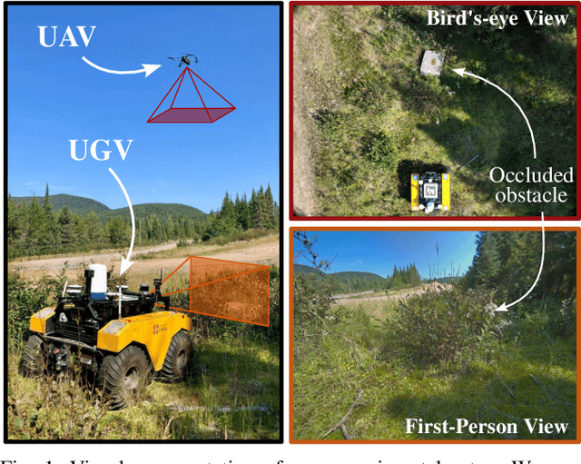
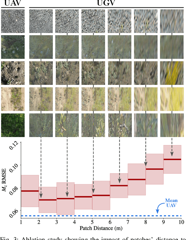
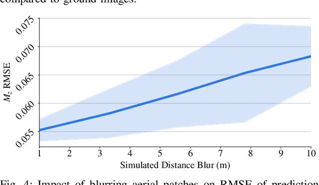
Abstract:Terrain awareness is an essential milestone to enable truly autonomous off-road navigation. Accurately predicting terrain characteristics allows optimizing a vehicle's path against potential hazards. Recent methods use deep neural networks to predict traversability-related terrain properties in a self-supervised manner, relying on proprioception as a training signal. However, onboard cameras are inherently limited by their point-of-view relative to the ground, suffering from occlusions and vanishing pixel density with distance. This paper introduces a novel approach for self-supervised terrain characterization using an aerial perspective from a hovering drone. We capture terrain-aligned images while sampling the environment with a ground vehicle, effectively training a simple predictor for vibrations, bumpiness, and energy consumption. Our dataset includes 2.8 km of off-road data collected in forest environment, comprising 13 484 ground-based images and 12 935 aerial images. Our findings show that drone imagery improves terrain property prediction by 21.37 % on the whole dataset and 37.35 % in high vegetation, compared to ground robot images. We conduct ablation studies to identify the main causes of these performance improvements. We also demonstrate the real-world applicability of our approach by scouting an unseen area with a drone, planning and executing an optimized path on the ground.
Field Report on a Wearable and Versatile Solution for Field Acquisition and Exploration
Apr 30, 2024Abstract:This report presents a wearable plug-and-play platform for data acquisition in the field. The platform, extending a waterproof Pelican Case into a 20 kg backpack offers 5.5 hours of power autonomy, while recording data with two cameras, a lidar, an Inertial Measurement Unit (IMU), and a Global Navigation Satellite System (GNSS) receiver. The system only requires a single operator and is readily controlled with a built-in screen and buttons. Due to its small footprint, it offers greater flexibility than large vehicles typically deployed in off-trail environments. We describe the platform's design, detailing the mechanical parts, electrical components, and software stack. We explain the system's limitations, drawing from its extensive deployment spanning over 20 kilometers of trajectories across various seasons, environments, and weather conditions. We derive valuable lessons learned from these deployments and present several possible applications for the system. The possible use cases consider not only academic research but also insights from consultations with our industrial partners. The mechanical design including all CAD files, as well as the software stack, are publicly available at https://github.com/norlab-ulaval/backpack_workspace.
Comparing Motion Distortion Between Vehicle Field Deployments
Apr 30, 2024Abstract:Recent advances in autonomous driving for uncrewed ground vehicles (UGVs) have spurred significant development, particularly in challenging terrains. This paper introduces a classification system assessing various UGV deployments reported in the literature. Our approach considers motion distortion features that include internal UGV features, such as mass and speed, and external features, such as terrain complexity, which all influence the efficiency of models and navigation systems. We present results that map UGV deployments relative to vehicle kinetic energy and terrain complexity, providing insights into the level of complexity and risk associated with different operational environments. Additionally, we propose a motion distortion metric to assess UGV navigation performance that does not require an explicit quantification of motion distortion features. Using this metric, we conduct a case study to illustrate the impact of motion distortion features on modeling accuracy. This research advocates for creating a comprehensive database containing many different motion distortion features, which would contribute to advancing the understanding of autonomous driving capabilities in rough conditions and provide a validation framework for future developments in UGV navigation systems.
3D Mapping of Glacier Moulins: Challenges and lessons learned
Apr 29, 2024


Abstract:In this paper, we present a field report of the mapping of the Athabasca Glacier, using a custom-made lidar-inertial mapping platform. With the increasing autonomy of robotics, a wider spectrum of applications emerges. Among these, the surveying of environmental areas presents arduous and hazardous challenges for human operators. Leveraging automated platforms for data collection holds the promise of unlocking new applications and a deeper comprehension of the environment. Over the course of a week-long deployment, we collected glacier data using a tailor-made measurement platform and reflected on the inherent challenges associated with such experiments. We focus on the insights gained and the forthcoming challenges that robotics must surmount to effectively map these terrains.
FoMo: A Proposal for a Multi-Season Dataset for Robot Navigation in Forêt Montmorency
Apr 19, 2024Abstract:In this paper, we propose the FoMo (For\^et Montmorency) dataset: a comprehensive, multi-season data collection. Located in the Montmorency Forest, Quebec, Canada, our dataset will capture a rich variety of sensory data over six distinct trajectories totaling 6 kilometers, repeated through different seasons to accumulate 42 kilometers of recorded data. The boreal forest environment increases the diversity of datasets for mobile robot navigation. This proposed dataset will feature a broad array of sensor modalities, including lidar, radar, and a navigation-grade Inertial Measurement Unit (IMU), against the backdrop of challenging boreal forest conditions. Notably, the FoMo dataset will be distinguished by its inclusion of seasonal variations, such as changes in tree canopy and snow depth up to 2 meters, presenting new challenges for robot navigation algorithms. Alongside, we will offer a centimeter-level accurate ground truth, obtained through Post Processed Kinematic (PPK) Global Navigation Satellite System (GNSS) correction, facilitating precise evaluation of odometry and localization algorithms. This work aims to spur advancements in autonomous navigation, enabling the development of robust algorithms capable of handling the dynamic, unstructured environments characteristic of boreal forests. With a public odometry and localization leaderboard and a dedicated software suite, we invite the robotics community to engage with the FoMo dataset by exploring new frontiers in robot navigation under extreme environmental variations. We seek feedback from the community based on this proposal to make the dataset as useful as possible. For further details and supplementary materials, please visit https://norlab-ulaval.github.io/FoMo-website/.
Proprioception Is All You Need: Terrain Classification for Boreal Forests
Mar 25, 2024


Abstract:Recent works in field robotics highlighted the importance of resiliency against different types of terrains. Boreal forests, in particular, are home to many mobility-impeding terrains that should be considered for off-road autonomous navigation. Also, being one of the largest land biomes on Earth, boreal forests are an area where autonomous vehicles are expected to become increasingly common. In this paper, we address this issue by introducing BorealTC, a publicly available dataset for proprioceptive-based terrain classification (TC). Recorded with a Husky A200, our dataset contains 116 min of Inertial Measurement Unit (IMU), motor current, and wheel odometry data, focusing on typical boreal forest terrains, notably snow, ice, and silty loam. Combining our dataset with another dataset from the state-of-the-art, we evaluate both a Convolutional Neural Network (CNN) and the novel state space model (SSM)-based Mamba architecture on a TC task. Interestingly, we show that while CNN outperforms Mamba on each separate dataset, Mamba achieves greater accuracy when trained on a combination of both. In addition, we demonstrate that Mamba's learning capacity is greater than a CNN for increasing amounts of data. We show that the combination of two TC datasets yields a latent space that can be interpreted with the properties of the terrains. We also discuss the implications of merging datasets on classification. Our source code and dataset are publicly available online: https://github.com/norlab-ulaval/BorealTC.
 Add to Chrome
 Add to Firefox
 Add to Edge