 Add to Chrome
 Add to Firefox
 Add to Edge
Invariant Features for Global Crop Type Classification
Sep 04, 2025


Accurately obtaining crop type and its spatial distribution at a global scale is critical for food security, agricultural policy-making, and sustainable development. Remote sensing offers an efficient solution for large-scale crop classification, but the limited availability of reliable ground samples in many regions constrains applicability across geographic areas. To address performance declines under geospatial shifts, this study identifies remote sensing features that are invariant to geographic variation and proposes strategies to enhance cross-regional generalization. We construct CropGlobe, a global crop type dataset with 300,000 pixel-level samples from eight countries across five continents, covering six major food and industrial crops (corn, soybeans, rice, wheat, sugarcane, cotton). With broad geographic coverage, CropGlobe enables a systematic evaluation under cross-country, cross-continent, and cross-hemisphere transfer. We compare the transferability of temporal multi-spectral features (Sentinel-2-based 1D/2D median features and harmonic coefficients) and hyperspectral features (from EMIT). To improve generalization under spectral and phenological shifts, we design CropNet, a lightweight and robust CNN tailored for pixel-level crop classification, coupled with temporal data augmentation (time shift, time scale, and magnitude warping) that simulates realistic cross-regional phenology. Experiments show that 2D median temporal features from Sentinel-2 consistently exhibit the strongest invariance across all transfer scenarios, and augmentation further improves robustness, particularly when training data diversity is limited. Overall, the work identifies more invariant feature representations that enhance geographic transferability and suggests a promising path toward scalable, low-cost crop type applications across globally diverse regions.
Global High Categorical Resolution Land Cover Mapping via Weak Supervision
Jun 02, 2024

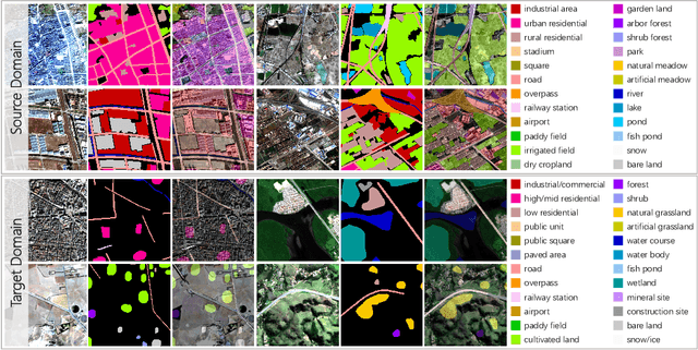
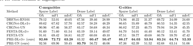
Land cover information is indispensable for advancing the United Nations' sustainable development goals, and land cover mapping under a more detailed category system would significantly contribute to economic livelihood tracking and environmental degradation measurement. However, the substantial difficulty in acquiring fine-grained training data makes the implementation of this task particularly challenging. Here, we propose to combine fully labeled source domain and weakly labeled target domain for weakly supervised domain adaptation (WSDA). This is beneficial as the utilization of sparse and coarse weak labels can considerably alleviate the labor required for precise and detailed land cover annotation. Specifically, we introduce the Prototype-based pseudo-label Rectification and Expansion (PRE) approach, which leverages the prototypes (i.e., the class-wise feature centroids) as the bridge to connect sparse labels and global feature distributions. According to the feature distances to the prototypes, the confidence of pseudo-labels predicted in the unlabeled regions of the target domain is assessed. This confidence is then utilized to guide the dynamic expansion and rectification of pseudo-labels. Based on PRE, we carry out high categorical resolution land cover mapping for 10 cities in different regions around the world, severally using PlanetScope, Gaofen-1, and Sentinel-2 satellite images. In the study areas, we achieve cross-sensor, cross-category, and cross-continent WSDA, with the overall accuracy exceeding 80%. The promising results indicate that PRE is capable of reducing the dependency of land cover classification on high-quality annotations, thereby improving label efficiency. We expect our work to enable global fine-grained land cover mapping, which in turn promote Earth observation to provide more precise and thorough information for environmental monitoring.
Enabling Country-Scale Land Cover Mapping with Meter-Resolution Satellite Imagery
Sep 01, 2022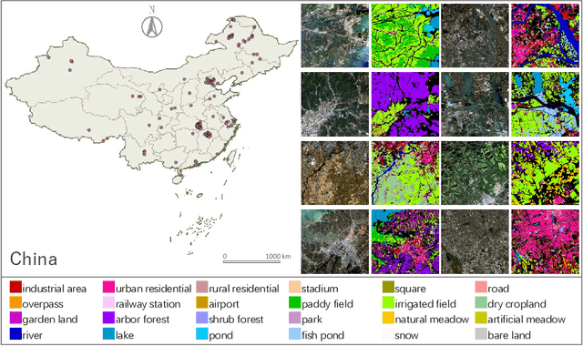
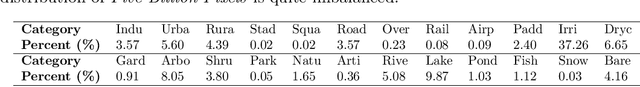
High-resolution satellite images can provide abundant, detailed spatial information for land cover classification, which is particularly important for studying the complicated built environment. However, due to the complex land cover patterns, the costly training sample collections, and the severe distribution shifts of satellite imageries, few studies have applied high-resolution images to land cover mapping in detailed categories at large scale. To fill this gap, we present a large-scale land cover dataset, Five-Billion-Pixels. It contains more than 5 billion labeled pixels of 150 high-resolution Gaofen-2 (4 m) satellite images, annotated in a 24-category system covering artificial-constructed, agricultural, and natural classes. In addition, we propose a deep-learning-based unsupervised domain adaptation approach that can transfer classification models trained on labeled dataset (referred to as the source domain) to unlabeled data (referred to as the target domain) for large-scale land cover mapping. Specifically, we introduce an end-to-end Siamese network employing dynamic pseudo-label assignment and class balancing strategy to perform adaptive domain joint learning. To validate the generalizability of our dataset and the proposed approach across different sensors and different geographical regions, we carry out land cover mapping on five megacities in China and six cities in other five Asian countries severally using: PlanetScope (3 m), Gaofen-1 (8 m), and Sentinel-2 (10 m) satellite images. Over a total study area of 60,000 square kilometers, the experiments show promising results even though the input images are entirely unlabeled. The proposed approach, trained with the Five-Billion-Pixels dataset, enables high-quality and detailed land cover mapping across the whole country of China and some other Asian countries at meter-resolution.
Hidden Path Selection Network for Semantic Segmentation of Remote Sensing Images
Dec 09, 2021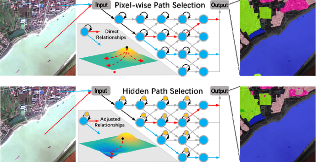
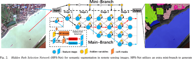
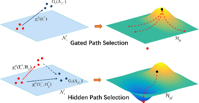
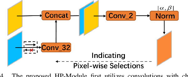
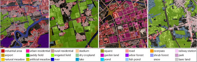
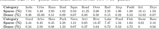
Targeting at depicting land covers with pixel-wise semantic categories, semantic segmentation in remote sensing images needs to portray diverse distributions over vast geographical locations, which is difficult to be achieved by the homogeneous pixel-wise forward paths in the architectures of existing deep models. Although several algorithms have been designed to select pixel-wise adaptive forward paths for natural image analysis, it still lacks theoretical supports on how to obtain optimal selections. In this paper, we provide mathematical analyses in terms of the parameter optimization, which guides us to design a method called Hidden Path Selection Network (HPS-Net). With the help of hidden variables derived from an extra mini-branch, HPS-Net is able to tackle the inherent problem about inaccessible global optimums by adjusting the direct relationships between feature maps and pixel-wise path selections in existing algorithms, which we call hidden path selection. For the better training and evaluation, we further refine and expand the 5-class Gaofen Image Dataset (GID-5) to a new one with 15 land-cover categories, i.e., GID-15. The experimental results on both GID-5 and GID-15 demonstrate that the proposed modules can stably improve the performance of different deep structures, which validates the proposed mathematical analyses.
Learning Transferable Deep Models for Land-Use Classification with High-Resolution Remote Sensing Images
Jul 16, 2018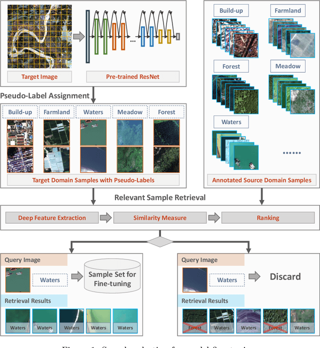
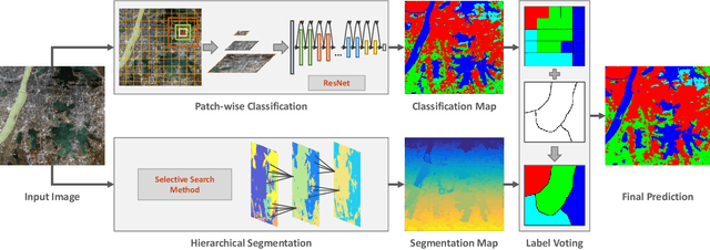
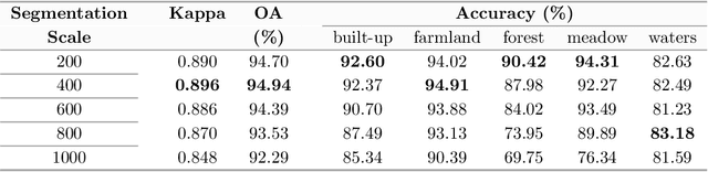
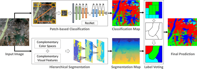
In recent years, large amount of high spatial-resolution remote sensing (HRRS) images are available for land-use mapping. However, due to the complex information brought by the increased spatial resolution and the data disturbances caused by different conditions of image acquisition, it is often difficult to find an efficient method for achieving accurate land-use classification with heterogeneous and high-resolution remote sensing images. In this paper, we propose a scheme to learn transferable deep models for land-use classification with HRRS images. The main idea is to rely on deep neural networks for presenting the semantic information contained in different types of land-uses and propose a pseudo-labeling and sample selection scheme for improving the transferability of deep models. More precisely, a deep Convolutional Neural Networks (CNNs) is first pre-trained with a well-annotated land-use dataset, referred to as the source data. Then, given a target image with no labels, the pre-trained CNN model is utilized to classify the image in a patch-wise manner. The patches with high classification probability are assigned with pseudo-labels and employed as the queries to retrieve related samples from the source data. The pseudo-labels confirmed with the retrieved results are regarded as supervised information for fine-tuning the pre-trained deep model. In order to obtain a pixel-wise land-use classification with the target image, we rely on the fine-tuned CNN and develop a hybrid classification by combining patch-wise classification and hierarchical segmentation. In addition, we create a large-scale land-use dataset containing $150$ Gaofen-2 satellite images for CNN pre-training. Experiments on multi-source HRRS images, including Gaofen-2, Gaofen-1, Jilin-1, Ziyuan-3, and Google Earth images, show encouraging results and demonstrate the efficiency of the proposed scheme.
Exploiting Deep Features for Remote Sensing Image Retrieval: A Systematic Investigation
Jul 15, 2018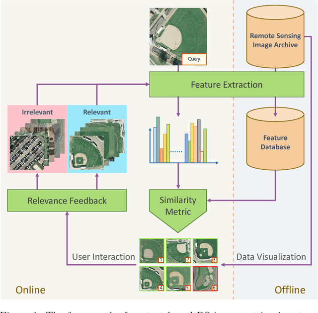
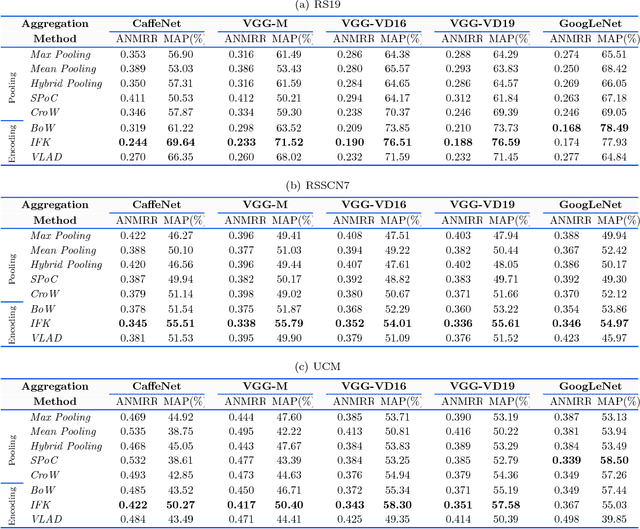
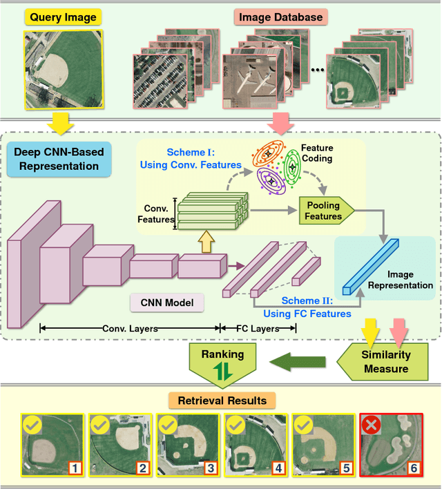
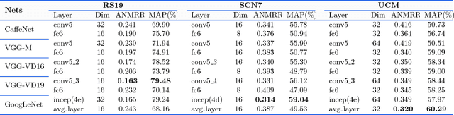
Remote sensing (RS) image retrieval based on visual content is of great significance for geological information mining. Over the past two decades, a large amount of research on this task has been carried out, which mainly focuses on the following three core issues of image retrieval: visual feature, similarity metric and relevance feedback. Along with the advance of these issues, the technology of RS image retrieval has been developed comparatively mature. However, due to the complexity and multiformity of high-resolution remote sensing (HRRS) images, there is still room for improvement in the current methods on HRRS data retrieval. In this paper, we analyze the three key aspects of retrieval and provide a comprehensive review on content-based RS image retrieval methods. Furthermore, for the goal to advance the state-of-the-art in HRRS image retrieval, we focus on the visual feature aspect and delve how to use powerful deep representations in this task. We conduct systematic investigation on evaluating factors that may affect the performance of deep features. By optimizing each factor, we acquire remarkable retrieval results on publicly available HRRS datasets. Finally, we explain the experimental phenomenon in detail and draw instructive conclusions according to our analysis. Our work can serve as a guiding role for the research of content-based RS image retrieval.
Large-scale Land Cover Classification in GaoFen-2 Satellite Imagery
Jun 04, 2018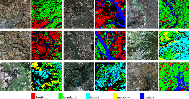
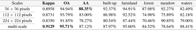

Many significant applications need land cover information of remote sensing images that are acquired from different areas and times, such as change detection and disaster monitoring. However, it is difficult to find a generic land cover classification scheme for different remote sensing images due to the spectral shift caused by diverse acquisition condition. In this paper, we develop a novel land cover classification method that can deal with large-scale data captured from widely distributed areas and different times. Additionally, we establish a large-scale land cover classification dataset consisting of 150 Gaofen-2 imageries as data support for model training and performance evaluation. Our experiments achieve outstanding classification accuracy compared with traditional methods.