Timothy Davis
Planet Labs GmbH, Germany
DynamicEarthNet: Daily Multi-Spectral Satellite Dataset for Semantic Change Segmentation
Mar 23, 2022
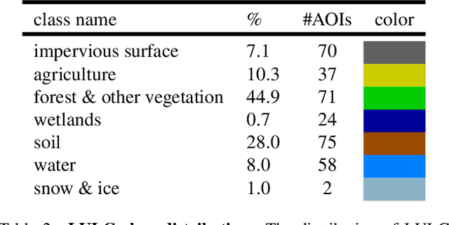
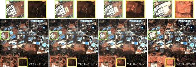

Abstract:Earth observation is a fundamental tool for monitoring the evolution of land use in specific areas of interest. Observing and precisely defining change, in this context, requires both time-series data and pixel-wise segmentations. To that end, we propose the DynamicEarthNet dataset that consists of daily, multi-spectral satellite observations of 75 selected areas of interest distributed over the globe with imagery from Planet Labs. These observations are paired with pixel-wise monthly semantic segmentation labels of 7 land use and land cover (LULC) classes. DynamicEarthNet is the first dataset that provides this unique combination of daily measurements and high-quality labels. In our experiments, we compare several established baselines that either utilize the daily observations as additional training data (semi-supervised learning) or multiple observations at once (spatio-temporal learning) as a point of reference for future research. Finally, we propose a new evaluation metric SCS that addresses the specific challenges associated with time-series semantic change segmentation. The data is available at: https://mediatum.ub.tum.de/1650201.
RapidAI4EO: A Corpus for Higher Spatial and Temporal Reasoning
Oct 05, 2021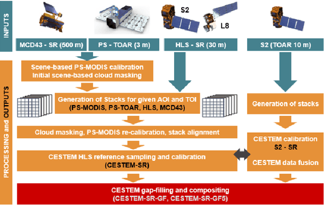


Abstract:Under the sponsorship of the European Union Horizon 2020 program, RapidAI4EO will establish the foundations for the next generation of Copernicus Land Monitoring Service (CLMS) products. The project aims to provide intensified monitoring of Land Use (LU), Land Cover (LC), and LU change at a much higher level of detail and temporal cadence than it is possible today. Focus is on disentangling phenology from structural change and in providing critical training data to drive advancement in the Copernicus community and ecosystem well beyond the lifetime of this project. To this end we are creating the densest spatiotemporal training sets ever by fusing open satellite data with Planet imagery at as many as 500,000 patch locations over Europe and delivering high resolution daily time series at all locations. We plan to open source these datasets for the benefit of the entire remote sensing community.
Mathematics of Digital Hyperspace
Mar 28, 2021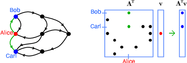
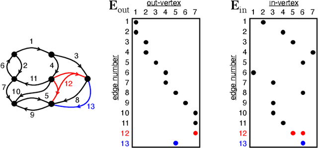
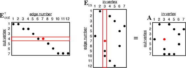

Abstract:Social media, e-commerce, streaming video, e-mail, cloud documents, web pages, traffic flows, and network packets fill vast digital lakes, rivers, and oceans that we each navigate daily. This digital hyperspace is an amorphous flow of data supported by continuous streams that stretch standard concepts of type and dimension. The unstructured data of digital hyperspace can be elegantly represented, traversed, and transformed via the mathematics of hypergraphs, hypersparse matrices, and associative array algebra. This paper explores a novel mathematical concept, the semilink, that combines pairs of semirings to provide the essential operations for graph analytics, database operations, and machine learning. The GraphBLAS standard currently supports hypergraphs, hypersparse matrices, the mathematics required for semilinks, and seamlessly performs graph, network, and matrix operations. With the addition of key based indices (such as pointers to strings) and semilinks, GraphBLAS can become a richer associative array algebra and be a plug-in replacement for spreadsheets, database tables, and data centric operating systems, enhancing the navigation of unstructured data found in digital hyperspace.
 Add to Chrome
 Add to Firefox
 Add to Edge