Giovanni Marchisio
Planet Labs Inc., USA
RapidAI4EO: Mono- and Multi-temporal Deep Learning models for Updating the CORINE Land Cover Product
Oct 26, 2022


Abstract:In the remote sensing community, Land Use Land Cover (LULC) classification with satellite imagery is a main focus of current research activities. Accurate and appropriate LULC classification, however, continues to be a challenging task. In this paper, we evaluate the performance of multi-temporal (monthly time series) compared to mono-temporal (single time step) satellite images for multi-label classification using supervised learning on the RapidAI4EO dataset. As a first step, we trained our CNN model on images at a single time step for multi-label classification, i.e. mono-temporal. We incorporated time-series images using a LSTM model to assess whether or not multi-temporal signals from satellites improves CLC classification. The results demonstrate an improvement of approximately 0.89% in classifying satellite imagery on 15 classes using a multi-temporal approach on monthly time series images compared to the mono-temporal approach. Using features from multi-temporal or mono-temporal images, this work is a step towards an efficient change detection and land monitoring approach.
DynamicEarthNet: Daily Multi-Spectral Satellite Dataset for Semantic Change Segmentation
Mar 23, 2022
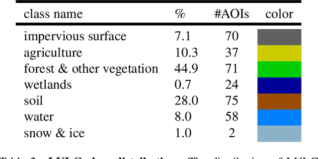
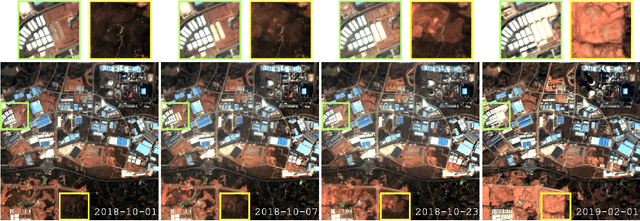

Abstract:Earth observation is a fundamental tool for monitoring the evolution of land use in specific areas of interest. Observing and precisely defining change, in this context, requires both time-series data and pixel-wise segmentations. To that end, we propose the DynamicEarthNet dataset that consists of daily, multi-spectral satellite observations of 75 selected areas of interest distributed over the globe with imagery from Planet Labs. These observations are paired with pixel-wise monthly semantic segmentation labels of 7 land use and land cover (LULC) classes. DynamicEarthNet is the first dataset that provides this unique combination of daily measurements and high-quality labels. In our experiments, we compare several established baselines that either utilize the daily observations as additional training data (semi-supervised learning) or multiple observations at once (spatio-temporal learning) as a point of reference for future research. Finally, we propose a new evaluation metric SCS that addresses the specific challenges associated with time-series semantic change segmentation. The data is available at: https://mediatum.ub.tum.de/1650201.
RapidAI4EO: A Corpus for Higher Spatial and Temporal Reasoning
Oct 05, 2021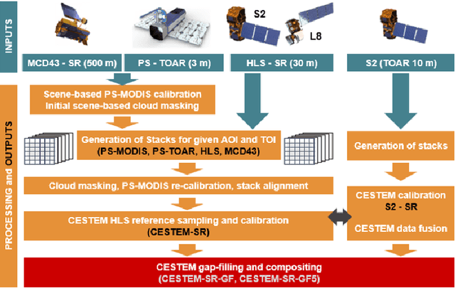


Abstract:Under the sponsorship of the European Union Horizon 2020 program, RapidAI4EO will establish the foundations for the next generation of Copernicus Land Monitoring Service (CLMS) products. The project aims to provide intensified monitoring of Land Use (LU), Land Cover (LC), and LU change at a much higher level of detail and temporal cadence than it is possible today. Focus is on disentangling phenology from structural change and in providing critical training data to drive advancement in the Copernicus community and ecosystem well beyond the lifetime of this project. To this end we are creating the densest spatiotemporal training sets ever by fusing open satellite data with Planet imagery at as many as 500,000 patch locations over Europe and delivering high resolution daily time series at all locations. We plan to open source these datasets for the benefit of the entire remote sensing community.
Super-Resolving Beyond Satellite Hardware Using Realistically Degraded Images
Mar 10, 2021

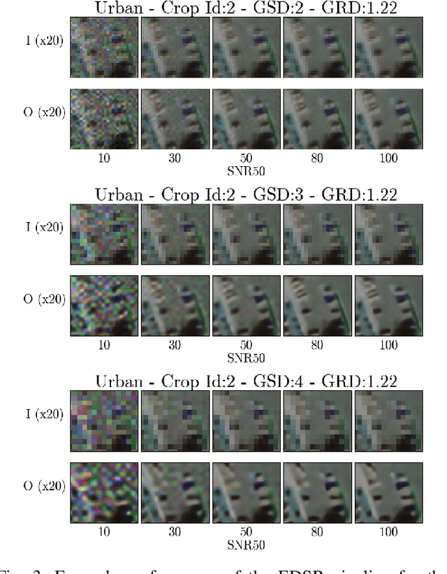
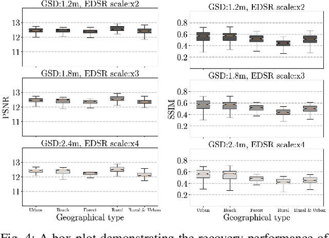
Abstract:Modern deep Super-Resolution (SR) networks have established themselves as valuable techniques in image reconstruction and enhancement. However, these networks are normally trained and tested on benchmark image data that lacks the typical image degrading noise present in real images. In this paper, we test the feasibility of using deep SR in real remote sensing payloads by assessing SR performance in reconstructing realistically degraded satellite images. We demonstrate that a state-of-the-art SR technique called Enhanced Deep Super-Resolution Network (EDSR), without domain specific pre-training, can recover encoded pixel data on images with poor ground sampling distance, provided the ground resolved distance is sufficient. However, this recovery varies amongst selected geographical types. Our results indicate that custom training has potential to further improve reconstruction of overhead imagery, and that new satellite hardware should prioritise optical performance over minimising pixel size as deep SR can overcome a lack of the latter but not the former.
 Add to Chrome
 Add to Firefox
 Add to Edge