Aysim Toker
SATGround: A Spatially-Aware Approach for Visual Grounding in Remote Sensing
Dec 09, 2025Abstract:Vision-language models (VLMs) are emerging as powerful generalist tools for remote sensing, capable of integrating information across diverse tasks and enabling flexible, instruction-based interactions via a chat interface. In this work, we enhance VLM-based visual grounding in satellite imagery by proposing a novel structured localization mechanism. Our approach involves finetuning a pretrained VLM on a diverse set of instruction-following tasks, while interfacing a dedicated grounding module through specialized control tokens for localization. This method facilitates joint reasoning over both language and spatial information, significantly enhancing the model's ability to precisely localize objects in complex satellite scenes. We evaluate our framework on several remote sensing benchmarks, consistently improving the state-of-the-art, including a 24.8% relative improvement over previous methods on visual grounding. Our results highlight the benefits of integrating structured spatial reasoning into VLMs, paving the way for more reliable real-world satellite data analysis.
SatSynth: Augmenting Image-Mask Pairs through Diffusion Models for Aerial Semantic Segmentation
Mar 25, 2024
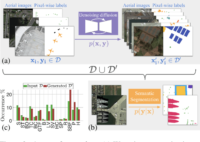

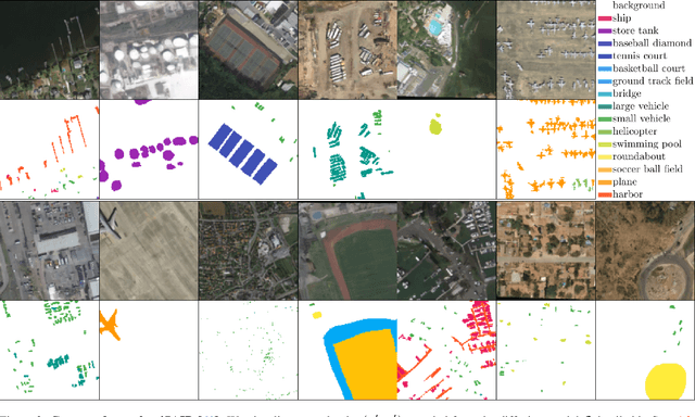
Abstract:In recent years, semantic segmentation has become a pivotal tool in processing and interpreting satellite imagery. Yet, a prevalent limitation of supervised learning techniques remains the need for extensive manual annotations by experts. In this work, we explore the potential of generative image diffusion to address the scarcity of annotated data in earth observation tasks. The main idea is to learn the joint data manifold of images and labels, leveraging recent advancements in denoising diffusion probabilistic models. To the best of our knowledge, we are the first to generate both images and corresponding masks for satellite segmentation. We find that the obtained pairs not only display high quality in fine-scale features but also ensure a wide sampling diversity. Both aspects are crucial for earth observation data, where semantic classes can vary severely in scale and occurrence frequency. We employ the novel data instances for downstream segmentation, as a form of data augmentation. In our experiments, we provide comparisons to prior works based on discriminative diffusion models or GANs. We demonstrate that integrating generated samples yields significant quantitative improvements for satellite semantic segmentation -- both compared to baselines and when training only on the original data.
G-MSM: Unsupervised Multi-Shape Matching with Graph-based Affinity Priors
Dec 06, 2022Abstract:We present G-MSM (Graph-based Multi-Shape Matching), a novel unsupervised learning approach for non-rigid shape correspondence. Rather than treating a collection of input poses as an unordered set of samples, we explicitly model the underlying shape data manifold. To this end, we propose an adaptive multi-shape matching architecture that constructs an affinity graph on a given set of training shapes in a self-supervised manner. The key idea is to combine putative, pairwise correspondences by propagating maps along shortest paths in the underlying shape graph. During training, we enforce cycle-consistency between such optimal paths and the pairwise matches which enables our model to learn topology-aware shape priors. We explore different classes of shape graphs and recover specific settings, like template-based matching (star graph) or learnable ranking/sorting (TSP graph), as special cases in our framework. Finally, we demonstrate state-of-the-art performance on several recent shape correspondence benchmarks, including real-world 3D scan meshes with topological noise and challenging inter-class pairs.
A Unified Framework for Implicit Sinkhorn Differentiation
May 13, 2022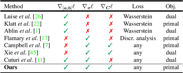


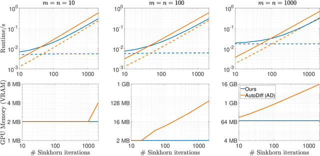
Abstract:The Sinkhorn operator has recently experienced a surge of popularity in computer vision and related fields. One major reason is its ease of integration into deep learning frameworks. To allow for an efficient training of respective neural networks, we propose an algorithm that obtains analytical gradients of a Sinkhorn layer via implicit differentiation. In comparison to prior work, our framework is based on the most general formulation of the Sinkhorn operator. It allows for any type of loss function, while both the target capacities and cost matrices are differentiated jointly. We further construct error bounds of the resulting algorithm for approximate inputs. Finally, we demonstrate that for a number of applications, simply replacing automatic differentiation with our algorithm directly improves the stability and accuracy of the obtained gradients. Moreover, we show that it is computationally more efficient, particularly when resources like GPU memory are scarce.
DynamicEarthNet: Daily Multi-Spectral Satellite Dataset for Semantic Change Segmentation
Mar 23, 2022
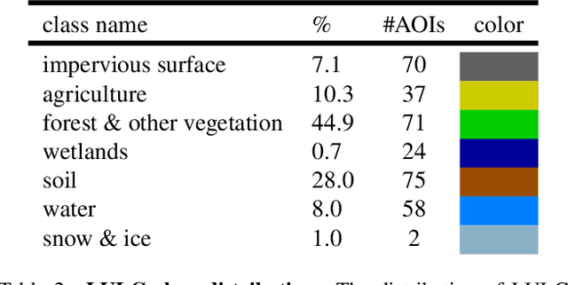
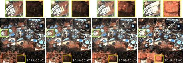

Abstract:Earth observation is a fundamental tool for monitoring the evolution of land use in specific areas of interest. Observing and precisely defining change, in this context, requires both time-series data and pixel-wise segmentations. To that end, we propose the DynamicEarthNet dataset that consists of daily, multi-spectral satellite observations of 75 selected areas of interest distributed over the globe with imagery from Planet Labs. These observations are paired with pixel-wise monthly semantic segmentation labels of 7 land use and land cover (LULC) classes. DynamicEarthNet is the first dataset that provides this unique combination of daily measurements and high-quality labels. In our experiments, we compare several established baselines that either utilize the daily observations as additional training data (semi-supervised learning) or multiple observations at once (spatio-temporal learning) as a point of reference for future research. Finally, we propose a new evaluation metric SCS that addresses the specific challenges associated with time-series semantic change segmentation. The data is available at: https://mediatum.ub.tum.de/1650201.
Spatial Context Awareness for Unsupervised Change Detection in Optical Satellite Images
Oct 05, 2021
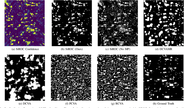
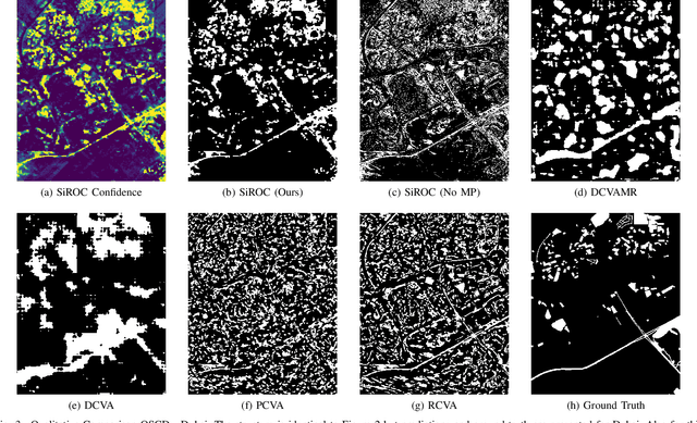
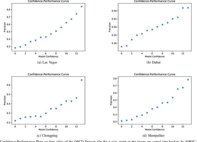
Abstract:Detecting changes on the ground in multitemporal Earth observation data is one of the key problems in remote sensing. In this paper, we introduce Sibling Regression for Optical Change detection (SiROC), an unsupervised method for change detection in optical satellite images with medium and high resolution. SiROC is a spatial context-based method that models a pixel as a linear combination of its distant neighbors. It uses this model to analyze differences in the pixel and its spatial context-based predictions in subsequent time periods for change detection. We combine this spatial context-based change detection with ensembling over mutually exclusive neighborhoods and transitioning from pixel to object-level changes with morphological operations. SiROC achieves competitive performance for change detection with medium-resolution Sentinel-2 and high-resolution Planetscope imagery on four datasets. Besides accurate predictions without the need for training, SiROC also provides a well-calibrated uncertainty of its predictions. This makes the method especially useful in conjunction with deep-learning based methods for applications such as pseudo-labeling.
Coming Down to Earth: Satellite-to-Street View Synthesis for Geo-Localization
Mar 11, 2021
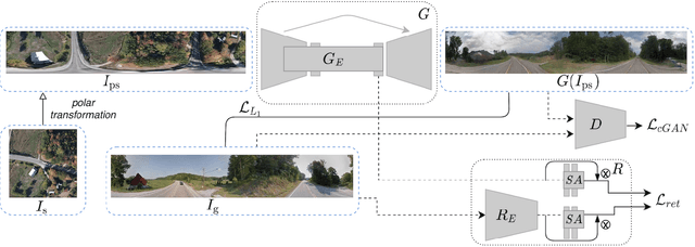

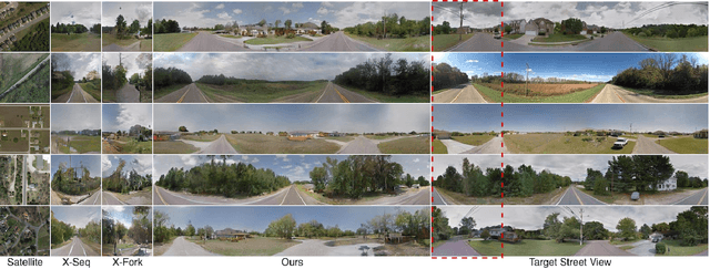
Abstract:The goal of cross-view image based geo-localization is to determine the location of a given street view image by matching it against a collection of geo-tagged satellite images. This task is notoriously challenging due to the drastic viewpoint and appearance differences between the two domains. We show that we can address this discrepancy explicitly by learning to synthesize realistic street views from satellite inputs. Following this observation, we propose a novel multi-task architecture in which image synthesis and retrieval are considered jointly. The rationale behind this is that we can bias our network to learn latent feature representations that are useful for retrieval if we utilize them to generate images across the two input domains. To the best of our knowledge, ours is the first approach that creates realistic street views from satellite images and localizes the corresponding query street-view simultaneously in an end-to-end manner. In our experiments, we obtain state-of-the-art performance on the CVUSA and CVACT benchmarks. Finally, we show compelling qualitative results for satellite-to-street view synthesis.
Deep Shells: Unsupervised Shape Correspondence with Optimal Transport
Oct 28, 2020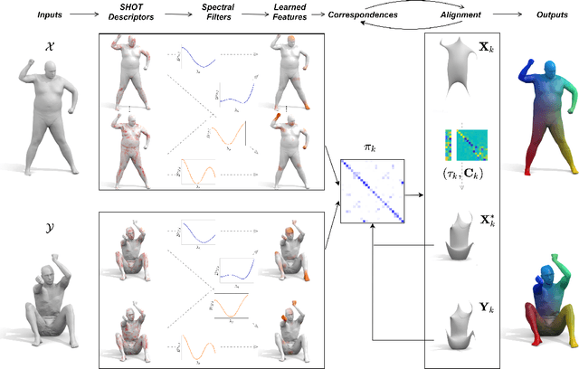
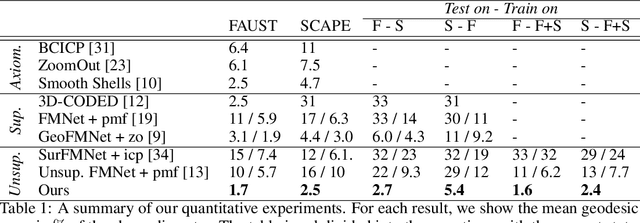
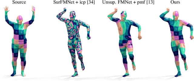

Abstract:We propose a novel unsupervised learning approach to 3D shape correspondence that builds a multiscale matching pipeline into a deep neural network. This approach is based on smooth shells, the current state-of-the-art axiomatic correspondence method, which requires an a priori stochastic search over the space of initial poses. Our goal is to replace this costly preprocessing step by directly learning good initializations from the input surfaces. To that end, we systematically derive a fully differentiable, hierarchical matching pipeline from entropy regularized optimal transport. This allows us to combine it with a local feature extractor based on smooth, truncated spectral convolution filters. Finally, we show that the proposed unsupervised method significantly improves over the state-of-the-art on multiple datasets, even in comparison to the most recent supervised methods. Moreover, we demonstrate compelling generalization results by applying our learned filters to examples that significantly deviate from the training set.
 Add to Chrome
 Add to Firefox
 Add to Edge