Stefano Puliti
Enhancing Tree Species Classification: Insights from YOLOv8 and Explainable AI Applied to TLS Point Cloud Projections
Dec 17, 2025


Abstract:Classifying tree species has been a core research area in forest remote sensing for decades. New sensors and classification approaches like TLS and deep learning achieve state-of-the art accuracy but their decision processes remain unclear. Methods such as Finer-CAM (Class Activation Mapping) can highlight features in TLS projections that contribute to the classification of a target species, yet are uncommon in similar looking contrastive tree species. We propose a novel method linking Finer-CAM explanations to segments of TLS projections representing structural tree features to systemically evaluate which features drive species discrimination. Using TLS data from 2,445 trees across seven European tree species, we trained and validated five YOLOv8 models with cross-validation, reaching a mean accuracy of 96% (SD = 0.24%). Analysis of 630 saliency maps shows the models primarily rely on crown features in TLS projections for species classification. While this result is pronounced in Silver Birch, European Beech, English oak, and Norway spruce, stem features contribute more frequently to the differentiation of European ash, Scots pine, and Douglas fir. Particularly representations of finer branches contribute to the decisions of the models. The models consider those tree species similar to each other which a human expert would also regard as similar. Furthermore, our results highlight the need for an improved understanding of the decision processes of tree species classification models to help reveal data set and model limitations, biases, and to build confidence in model predictions.
Multispectral airborne laser scanning for tree species classification: a benchmark of machine learning and deep learning algorithms
Apr 19, 2025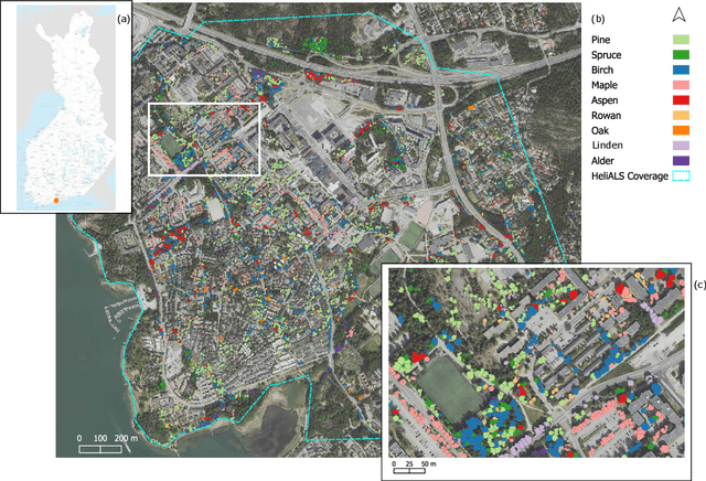
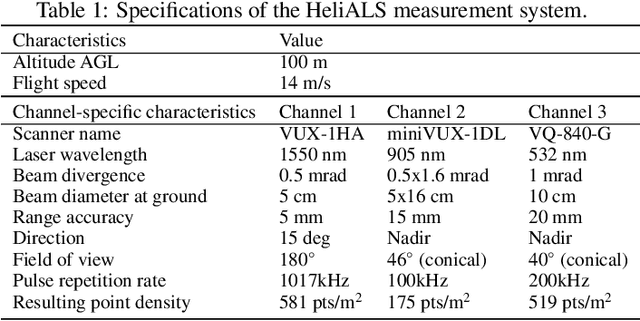
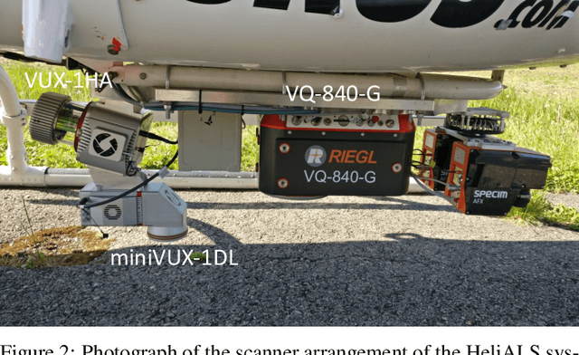
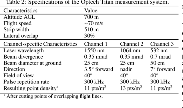
Abstract:Climate-smart and biodiversity-preserving forestry demands precise information on forest resources, extending to the individual tree level. Multispectral airborne laser scanning (ALS) has shown promise in automated point cloud processing and tree segmentation, but challenges remain in identifying rare tree species and leveraging deep learning techniques. This study addresses these gaps by conducting a comprehensive benchmark of machine learning and deep learning methods for tree species classification. For the study, we collected high-density multispectral ALS data (>1000 pts/m$^2$) at three wavelengths using the FGI-developed HeliALS system, complemented by existing Optech Titan data (35 pts/m$^2$), to evaluate the species classification accuracy of various algorithms in a test site located in Southern Finland. Based on 5261 test segments, our findings demonstrate that point-based deep learning methods, particularly a point transformer model, outperformed traditional machine learning and image-based deep learning approaches on high-density multispectral point clouds. For the high-density ALS dataset, a point transformer model provided the best performance reaching an overall (macro-average) accuracy of 87.9% (74.5%) with a training set of 1065 segments and 92.0% (85.1%) with 5000 training segments. The best image-based deep learning method, DetailView, reached an overall (macro-average) accuracy of 84.3% (63.9%), whereas a random forest (RF) classifier achieved an overall (macro-average) accuracy of 83.2% (61.3%). Importantly, the overall classification accuracy of the point transformer model on the HeliALS data increased from 73.0% with no spectral information to 84.7% with single-channel reflectance, and to 87.9% with spectral information of all the three channels.
Benchmarking tree species classification from proximally-sensed laser scanning data: introducing the FOR-species20K dataset
Aug 12, 2024Abstract:Proximally-sensed laser scanning offers significant potential for automated forest data capture, but challenges remain in automatically identifying tree species without additional ground data. Deep learning (DL) shows promise for automation, yet progress is slowed by the lack of large, diverse, openly available labeled datasets of single tree point clouds. This has impacted the robustness of DL models and the ability to establish best practices for species classification. To overcome these challenges, the FOR-species20K benchmark dataset was created, comprising over 20,000 tree point clouds from 33 species, captured using terrestrial (TLS), mobile (MLS), and drone laser scanning (ULS) across various European forests, with some data from other regions. This dataset enables the benchmarking of DL models for tree species classification, including both point cloud-based (PointNet++, MinkNet, MLP-Mixer, DGCNNs) and multi-view image-based methods (SimpleView, DetailView, YOLOv5). 2D image-based models generally performed better (average OA = 0.77) than 3D point cloud-based models (average OA = 0.72), with consistent results across different scanning platforms and sensors. The top model, DetailView, was particularly robust, handling data imbalances well and generalizing effectively across tree sizes. The FOR-species20K dataset, available at https://zenodo.org/records/13255198, is a key resource for developing and benchmarking DL models for tree species classification using laser scanning data, providing a foundation for future advancements in the field.
SegmentAnyTree: A sensor and platform agnostic deep learning model for tree segmentation using laser scanning data
Jan 28, 2024


Abstract:This research advances individual tree crown (ITC) segmentation in lidar data, using a deep learning model applicable to various laser scanning types: airborne (ULS), terrestrial (TLS), and mobile (MLS). It addresses the challenge of transferability across different data characteristics in 3D forest scene analysis. The study evaluates the model's performance based on platform (ULS, MLS) and data density, testing five scenarios with varying input data, including sparse versions, to gauge adaptability and canopy layer efficacy. The model, based on PointGroup architecture, is a 3D CNN with separate heads for semantic and instance segmentation, validated on diverse point cloud datasets. Results show point cloud sparsification enhances performance, aiding sparse data handling and improving detection in dense forests. The model performs well with >50 points per sq. m densities but less so at 10 points per sq. m due to higher omission rates. It outperforms existing methods (e.g., Point2Tree, TLS2trees) in detection, omission, commission rates, and F1 score, setting new benchmarks on LAUTx, Wytham Woods, and TreeLearn datasets. In conclusion, this study shows the feasibility of a sensor-agnostic model for diverse lidar data, surpassing sensor-specific approaches and setting new standards in tree segmentation, particularly in complex forests. This contributes to future ecological modeling and forest management advancements.
Automated forest inventory: analysis of high-density airborne LiDAR point clouds with 3D deep learning
Dec 22, 2023


Abstract:Detailed forest inventories are critical for sustainable and flexible management of forest resources, to conserve various ecosystem services. Modern airborne laser scanners deliver high-density point clouds with great potential for fine-scale forest inventory and analysis, but automatically partitioning those point clouds into meaningful entities like individual trees or tree components remains a challenge. The present study aims to fill this gap and introduces a deep learning framework that is able to perform such a segmentation across diverse forest types and geographic regions. From the segmented data, we then derive relevant biophysical parameters of individual trees as well as stands. The system has been tested on FOR-Instance, a dataset of point clouds that have been acquired in five different countries using surveying drones. The segmentation back-end achieves over 85% F-score for individual trees, respectively over 73% mean IoU across five semantic categories: ground, low vegetation, stems, live branches and dead branches. Building on the segmentation results our pipeline then densely calculates biophysical features of each individual tree (height, crown diameter, crown volume, DBH, and location) and properties per stand (digital terrain model and stand density). Especially crown-related features are in most cases retrieved with high accuracy, whereas the estimates for DBH and location are less reliable, due to the airborne scanning setup.
FOR-instance: a UAV laser scanning benchmark dataset for semantic and instance segmentation of individual trees
Sep 03, 2023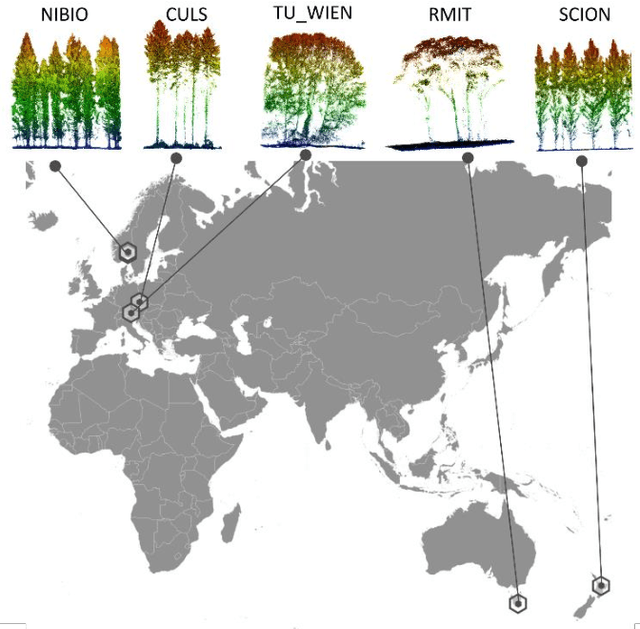

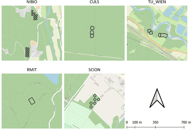

Abstract:The FOR-instance dataset (available at https://doi.org/10.5281/zenodo.8287792) addresses the challenge of accurate individual tree segmentation from laser scanning data, crucial for understanding forest ecosystems and sustainable management. Despite the growing need for detailed tree data, automating segmentation and tracking scientific progress remains difficult. Existing methodologies often overfit small datasets and lack comparability, limiting their applicability. Amid the progress triggered by the emergence of deep learning methodologies, standardized benchmarking assumes paramount importance in these research domains. This data paper introduces a benchmarking dataset for dense airborne laser scanning data, aimed at advancing instance and semantic segmentation techniques and promoting progress in 3D forest scene segmentation. The FOR-instance dataset comprises five curated and ML-ready UAV-based laser scanning data collections from diverse global locations, representing various forest types. The laser scanning data were manually annotated into individual trees (instances) and different semantic classes (e.g. stem, woody branches, live branches, terrain, low vegetation). The dataset is divided into development and test subsets, enabling method advancement and evaluation, with specific guidelines for utilization. It supports instance and semantic segmentation, offering adaptability to deep learning frameworks and diverse segmentation strategies, while the inclusion of diameter at breast height data expands its utility to the measurement of a classic tree variable. In conclusion, the FOR-instance dataset contributes to filling a gap in the 3D forest research, enhancing the development and benchmarking of segmentation algorithms for dense airborne laser scanning data.
Towards accurate instance segmentation in large-scale LiDAR point clouds
Jul 06, 2023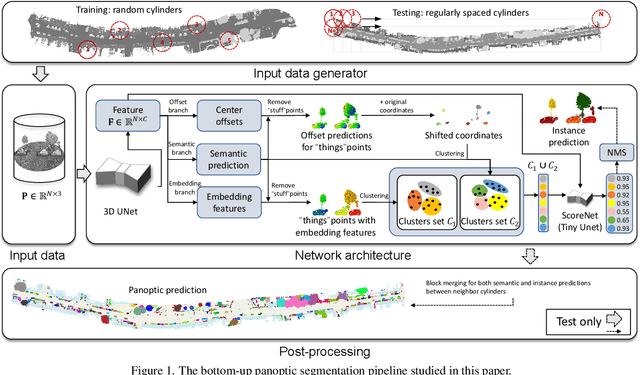
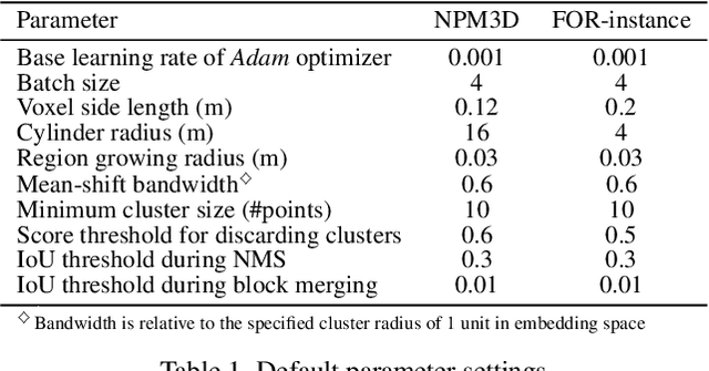
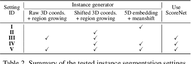

Abstract:Panoptic segmentation is the combination of semantic and instance segmentation: assign the points in a 3D point cloud to semantic categories and partition them into distinct object instances. It has many obvious applications for outdoor scene understanding, from city mapping to forest management. Existing methods struggle to segment nearby instances of the same semantic category, like adjacent pieces of street furniture or neighbouring trees, which limits their usability for inventory- or management-type applications that rely on object instances. This study explores the steps of the panoptic segmentation pipeline concerned with clustering points into object instances, with the goal to alleviate that bottleneck. We find that a carefully designed clustering strategy, which leverages multiple types of learned point embeddings, significantly improves instance segmentation. Experiments on the NPM3D urban mobile mapping dataset and the FOR-instance forest dataset demonstrate the effectiveness and versatility of the proposed strategy.
Point2Tree(P2T) -- framework for parameter tuning of semantic and instance segmentation used with mobile laser scanning data in coniferous forest
May 04, 2023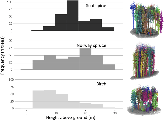


Abstract:This article introduces Point2Tree, a novel framework that incorporates a three-stage process involving semantic segmentation, instance segmentation, optimization analysis of hyperparemeters importance. It introduces a comprehensive and modular approach to processing laser points clouds in Forestry. We tested it on two independent datasets. The first area was located in an actively managed boreal coniferous dominated forest in V{\aa}ler, Norway, 16 circular plots of 400 square meters were selected to cover a range of forest conditions in terms of species composition and stand density. We trained a model based on Pointnet++ architecture which achieves 0.92 F1-score in semantic segmentation. As a second step in our pipeline we used graph-based approach for instance segmentation which reached F1-score approx. 0.6. The optimization allowed to further boost the performance of the pipeline by approx. 4 \% points.
AI applications in forest monitoring need remote sensing benchmark datasets
Dec 20, 2022Abstract:With the rise in high resolution remote sensing technologies there has been an explosion in the amount of data available for forest monitoring, and an accompanying growth in artificial intelligence applications to automatically derive forest properties of interest from these datasets. Many studies use their own data at small spatio-temporal scales, and demonstrate an application of an existing or adapted data science method for a particular task. This approach often involves intensive and time-consuming data collection and processing, but generates results restricted to specific ecosystems and sensor types. There is a lack of widespread acknowledgement of how the types and structures of data used affects performance and accuracy of analysis algorithms. To accelerate progress in the field more efficiently, benchmarking datasets upon which methods can be tested and compared are sorely needed. Here, we discuss how lack of standardisation impacts confidence in estimation of key forest properties, and how considerations of data collection need to be accounted for in assessing method performance. We present pragmatic requirements and considerations for the creation of rigorous, useful benchmarking datasets for forest monitoring applications, and discuss how tools from modern data science can improve use of existing data. We list a set of example large-scale datasets that could contribute to benchmarking, and present a vision for how community-driven, representative benchmarking initiatives could benefit the field.
Country-wide Retrieval of Forest Structure From Optical and SAR Satellite Imagery With Bayesian Deep Learning
Nov 25, 2021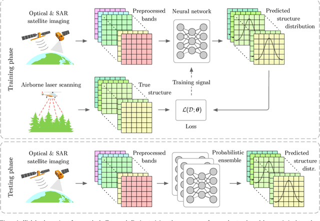
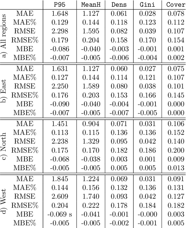
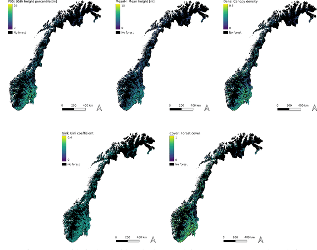
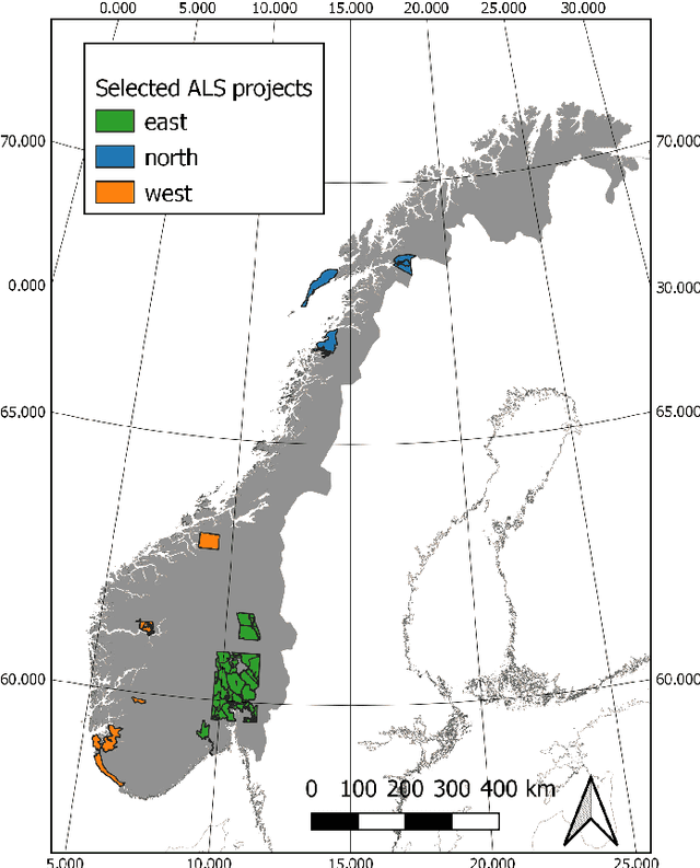
Abstract:Monitoring and managing Earth's forests in an informed manner is an important requirement for addressing challenges like biodiversity loss and climate change. While traditional in situ or aerial campaigns for forest assessments provide accurate data for analysis at regional level, scaling them to entire countries and beyond with high temporal resolution is hardly possible. In this work, we propose a Bayesian deep learning approach to densely estimate forest structure variables at country-scale with 10-meter resolution, using freely available satellite imagery as input. Our method jointly transforms Sentinel-2 optical images and Sentinel-1 synthetic aperture radar images into maps of five different forest structure variables: 95th height percentile, mean height, density, Gini coefficient, and fractional cover. We train and test our model on reference data from 41 airborne laser scanning missions across Norway and demonstrate that it is able to generalize to unseen test regions, achieving normalized mean absolute errors between 11% and 15%, depending on the variable. Our work is also the first to propose a Bayesian deep learning approach so as to predict forest structure variables with well-calibrated uncertainty estimates. These increase the trustworthiness of the model and its suitability for downstream tasks that require reliable confidence estimates, such as informed decision making. We present an extensive set of experiments to validate the accuracy of the predicted maps as well as the quality of the predicted uncertainties. To demonstrate scalability, we provide Norway-wide maps for the five forest structure variables.
 Add to Chrome
 Add to Firefox
 Add to Edge