Kai Yin
DisastQA: A Comprehensive Benchmark for Evaluating Question Answering in Disaster Management
Jan 07, 2026Abstract:Accurate question answering (QA) in disaster management requires reasoning over uncertain and conflicting information, a setting poorly captured by existing benchmarks built on clean evidence. We introduce DisastQA, a large-scale benchmark of 3,000 rigorously verified questions (2,000 multiple-choice and 1,000 open-ended) spanning eight disaster types. The benchmark is constructed via a human-LLM collaboration pipeline with stratified sampling to ensure balanced coverage. Models are evaluated under varying evidence conditions, from closed-book to noisy evidence integration, enabling separation of internal knowledge from reasoning under imperfect information. For open-ended QA, we propose a human-verified keypoint-based evaluation protocol emphasizing factual completeness over verbosity. Experiments with 20 models reveal substantial divergences from general-purpose leaderboards such as MMLU-Pro. While recent open-weight models approach proprietary systems in clean settings, performance degrades sharply under realistic noise, exposing critical reliability gaps for disaster response. All code, data, and evaluation resources are available at https://github.com/TamuChen18/DisastQA_open.
FloodSQL-Bench: A Retrieval-Augmented Benchmark for Geospatially-Grounded Text-to-SQL
Dec 12, 2025Abstract:Existing Text-to-SQL benchmarks primarily focus on single-table queries or limited joins in general-purpose domains, and thus fail to reflect the complexity of domain-specific, multi-table and geospatial reasoning, To address this limitation, we introduce FLOODSQL-BENCH, a geospatially grounded benchmark for the flood management domain that integrates heterogeneous datasets through key-based, spatial, and hybrid joins. The benchmark captures realistic flood-related information needs by combining social, infrastructural, and hazard data layers. We systematically evaluate recent large language models with the same retrieval-augmented generation settings and measure their performance across difficulty tiers. By providing a unified, open benchmark grounded in real-world disaster management data, FLOODSQL-BENCH establishes a practical testbed for advancing Text-to-SQL research in high-stakes application domains.
DisastIR: A Comprehensive Information Retrieval Benchmark for Disaster Management
May 20, 2025Abstract:Effective disaster management requires timely access to accurate and contextually relevant information. Existing Information Retrieval (IR) benchmarks, however, focus primarily on general or specialized domains, such as medicine or finance, neglecting the unique linguistic complexity and diverse information needs encountered in disaster management scenarios. To bridge this gap, we introduce DisastIR, the first comprehensive IR evaluation benchmark specifically tailored for disaster management. DisastIR comprises 9,600 diverse user queries and more than 1.3 million labeled query-passage pairs, covering 48 distinct retrieval tasks derived from six search intents and eight general disaster categories that include 301 specific event types. Our evaluations of 30 state-of-the-art retrieval models demonstrate significant performance variances across tasks, with no single model excelling universally. Furthermore, comparative analyses reveal significant performance gaps between general-domain and disaster management-specific tasks, highlighting the necessity of disaster management-specific benchmarks for guiding IR model selection to support effective decision-making in disaster management scenarios. All source codes and DisastIR are available at https://github.com/KaiYin97/Disaster_IR.
CrisisSense-LLM: Instruction Fine-Tuned Large Language Model for Multi-label Social Media Text Classification in Disaster Informatics
Jun 16, 2024


Abstract:In the field of crisis/disaster informatics, social media is increasingly being used for improving situational awareness to inform response and relief efforts. Efficient and accurate text classification tools have been a focal area of investigation in crisis informatics. However, current methods mostly rely on single-label text classification models, which fails to capture different insights embedded in dynamic and multifaceted disaster-related social media data. This study introduces a novel approach to disaster text classification by enhancing a pre-trained Large Language Model (LLM) through instruction fine-tuning targeted for multi-label classification of disaster-related tweets. Our methodology involves creating a comprehensive instruction dataset from disaster-related tweets, which is then used to fine-tune an open-source LLM, thereby embedding it with disaster-specific knowledge. This fine-tuned model can classify multiple aspects of disaster-related information simultaneously, such as the type of event, informativeness, and involvement of human aid, significantly improving the utility of social media data for situational awareness in disasters. The results demonstrate that this approach enhances the categorization of critical information from social media posts, thereby facilitating a more effective deployment for situational awareness during emergencies. This research paves the way for more advanced, adaptable, and robust disaster management tools, leveraging the capabilities of LLMs to improve real-time situational awareness and response strategies in disaster scenarios.
FloodDamageCast: Building Flood Damage Nowcasting with Machine Learning and Data Augmentation
May 23, 2024


Abstract:Near-real time estimation of damage to buildings and infrastructure, referred to as damage nowcasting in this study, is crucial for empowering emergency responders to make informed decisions regarding evacuation orders and infrastructure repair priorities during disaster response and recovery. Here, we introduce FloodDamageCast, a machine learning framework tailored for property flood damage nowcasting. The framework leverages heterogeneous data to predict residential flood damage at a resolution of 500 meters by 500 meters within Harris County, Texas, during the 2017 Hurricane Harvey. To deal with data imbalance, FloodDamageCast incorporates a generative adversarial networks-based data augmentation coupled with an efficient machine learning model. The results demonstrate the model's ability to identify high-damage spatial areas that would be overlooked by baseline models. Insights gleaned from flood damage nowcasting can assist emergency responders to more efficiently identify repair needs, allocate resources, and streamline on-the-ground inspections, thereby saving both time and effort.
Boundary-Aware Value Function Generation for Safe Stochastic Motion Planning
Mar 22, 2024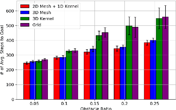
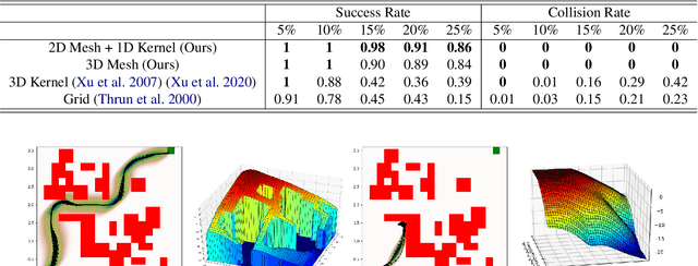

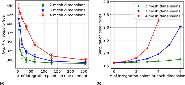
Abstract:Navigation safety is critical for many autonomous systems such as self-driving vehicles in an urban environment. It requires an explicit consideration of boundary constraints that describe the borders of any infeasible, non-navigable, or unsafe regions. We propose a principled boundary-aware safe stochastic planning framework with promising results. Our method generates a value function that can strictly distinguish the state values between free (safe) and non-navigable (boundary) spaces in the continuous state, naturally leading to a safe boundary-aware policy. At the core of our solution lies a seamless integration of finite elements and kernel-based functions, where the finite elements allow us to characterize safety-critical states' borders accurately, and the kernel-based function speeds up computation for the non-safety-critical states. The proposed method was evaluated through extensive simulations and demonstrated safe navigation behaviors in mobile navigation tasks. Additionally, we demonstrate that our approach can maneuver safely and efficiently in cluttered real-world environments using a ground vehicle with strong external disturbances, such as navigating on a slippery floor and against external human intervention.
Rethinking Urban Flood Risk Assessment By Adapting Health Domain Perspective
Mar 06, 2024Abstract:Inspired by ideas from health risk assessment, this paper presents a new perspective for flood risk assessment. The proposed perspective focuses on three pillars for examining flood risk: (1) inherent susceptibility, (2) mitigation strategies, and (3) external stressors. These pillars collectively encompass the physical and environmental characteristics of urban areas, the effectiveness of human-intervention measures, and the influence of uncontrollable external factors, offering a fresh point of view for decoding flood risks. For each pillar, we delineate its individual contributions to flood risk and illustrate their interactive and overall impact. The three-pillars model embodies a shift in focus from the quest to precisely model and quantify flood risk to evaluating pathways to high flood risk. The shift in perspective is intended to alleviate the quest for quantifying and predicting flood risk at fine resolutions as a panacea for enhanced flood risk management. The decomposition of flood risk pathways into the three intertwined pillars (i.e., inherent factors, mitigation factors, and external factors) enables evaluation of changes in factors within each pillar enhance and exacerbate flood risk, creating a platform from which to inform plans, decisions, and actions. Building on this foundation, we argue that a flood risk pathway analysis approach, which examines the individual and collective impacts of inherent factors, mitigation strategies, and external stressors, is essential for a nuanced evaluation of flood risk. Accordingly, the proposed perspective could complement the existing frameworks and approaches for flood risk assessment.
Deep Learning-driven Community Resilience Rating based on Intertwined Socio-Technical Systems Features
Nov 03, 2023
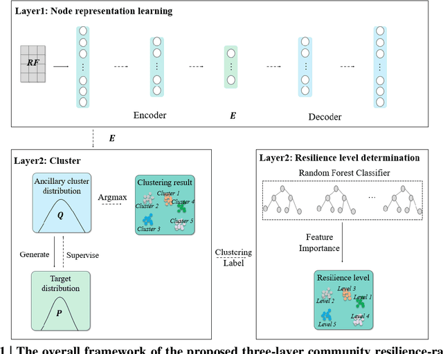


Abstract:Community resilience is a complex and muti-faceted phenomenon that emerges from complex and nonlinear interactions among different socio-technical systems and their resilience properties. However, present studies on community resilience focus primarily on vulnerability assessment and utilize index-based approaches, with limited ability to capture heterogeneous features within community socio-technical systems and their nonlinear interactions in shaping robustness, redundancy, and resourcefulness components of resilience. To address this gap, this paper presents an integrated three-layer deep learning model for community resilience rating (called Resili-Net). Twelve measurable resilience features are specified and computed within community socio-technical systems (i.e., facilities, infrastructures, and society) related to three resilience components of robustness, redundancy, and resourcefulness. Using publicly accessible data from multiple metropolitan statistical areas in the United States, Resili-Net characterizes the resilience levels of spatial areas into five distinct levels. The interpretability of the model outcomes enables feature analysis for specifying the determinants of resilience in areas within each resilience level, allowing for the identification of specific resilience enhancement strategies. Changes in community resilience profiles under urban development patterns are further examined by changing the value of related socio-technical systems features. Accordingly, the outcomes provide novel perspectives for community resilience assessment by harnessing machine intelligence and heterogeneous urban big data.
Unsupervised Graph Deep Learning Reveals Emergent Flood Risk Profile of Urban Areas
Oct 02, 2023Abstract:Urban flood risk emerges from complex and nonlinear interactions among multiple features related to flood hazard, flood exposure, and social and physical vulnerabilities, along with the complex spatial flood dependence relationships. Existing approaches for characterizing urban flood risk, however, are primarily based on flood plain maps, focusing on a limited number of features, primarily hazard and exposure features, without consideration of feature interactions or the dependence relationships among spatial areas. To address this gap, this study presents an integrated urban flood-risk rating model based on a novel unsupervised graph deep learning model (called FloodRisk-Net). FloodRisk-Net is capable of capturing spatial dependence among areas and complex and nonlinear interactions among flood hazards and urban features for specifying emergent flood risk. Using data from multiple metropolitan statistical areas (MSAs) in the United States, the model characterizes their flood risk into six distinct city-specific levels. The model is interpretable and enables feature analysis of areas within each flood-risk level, allowing for the identification of the three archetypes shaping the highest flood risk within each MSA. Flood risk is found to be spatially distributed in a hierarchical structure within each MSA, where the core city disproportionately bears the highest flood risk. Multiple cities are found to have high overall flood-risk levels and low spatial inequality, indicating limited options for balancing urban development and flood-risk reduction. Relevant flood-risk reduction strategies are discussed considering ways that the highest flood risk and uneven spatial distribution of flood risk are formed.
Causal Inference for De-biasing Motion Estimation from Robotic Observational Data
Oct 17, 2022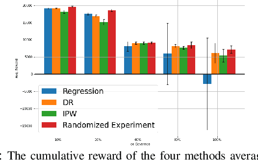

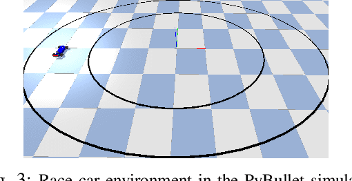
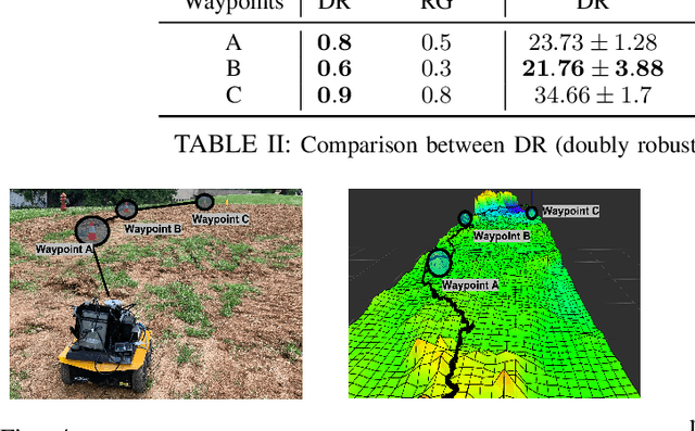
Abstract:Robot data collected in complex real-world scenarios are often biased due to safety concerns, human preferences, and mission or platform constraints. Consequently, robot learning from such observational data poses great challenges for accurate parameter estimation. We propose a principled causal inference framework for robots to learn the parameters of a stochastic motion model using observational data. Specifically, we leverage the de-biasing functionality of the potential-outcome causal inference framework, the Inverse Propensity Weighting (IPW), and the Doubly Robust (DR) methods, to obtain a better parameter estimation of the robot's stochastic motion model. The IPW is a re-weighting approach to ensure unbiased estimation, and the DR approach further combines any two estimators to strengthen the unbiased result even if one of these estimators is biased. We then develop an approximate policy iteration algorithm using the bias-eliminated estimated state transition function. We validate our framework using both simulation and real-world experiments, and the results have revealed that the proposed causal inference-based navigation and control framework can correctly and efficiently learn the parameters from biased observational data.
 Add to Chrome
 Add to Firefox
 Add to Edge