Zhewei Liu
DisastIR: A Comprehensive Information Retrieval Benchmark for Disaster Management
May 20, 2025Abstract:Effective disaster management requires timely access to accurate and contextually relevant information. Existing Information Retrieval (IR) benchmarks, however, focus primarily on general or specialized domains, such as medicine or finance, neglecting the unique linguistic complexity and diverse information needs encountered in disaster management scenarios. To bridge this gap, we introduce DisastIR, the first comprehensive IR evaluation benchmark specifically tailored for disaster management. DisastIR comprises 9,600 diverse user queries and more than 1.3 million labeled query-passage pairs, covering 48 distinct retrieval tasks derived from six search intents and eight general disaster categories that include 301 specific event types. Our evaluations of 30 state-of-the-art retrieval models demonstrate significant performance variances across tasks, with no single model excelling universally. Furthermore, comparative analyses reveal significant performance gaps between general-domain and disaster management-specific tasks, highlighting the necessity of disaster management-specific benchmarks for guiding IR model selection to support effective decision-making in disaster management scenarios. All source codes and DisastIR are available at https://github.com/KaiYin97/Disaster_IR.
Rethinking Urban Flood Risk Assessment By Adapting Health Domain Perspective
Mar 06, 2024Abstract:Inspired by ideas from health risk assessment, this paper presents a new perspective for flood risk assessment. The proposed perspective focuses on three pillars for examining flood risk: (1) inherent susceptibility, (2) mitigation strategies, and (3) external stressors. These pillars collectively encompass the physical and environmental characteristics of urban areas, the effectiveness of human-intervention measures, and the influence of uncontrollable external factors, offering a fresh point of view for decoding flood risks. For each pillar, we delineate its individual contributions to flood risk and illustrate their interactive and overall impact. The three-pillars model embodies a shift in focus from the quest to precisely model and quantify flood risk to evaluating pathways to high flood risk. The shift in perspective is intended to alleviate the quest for quantifying and predicting flood risk at fine resolutions as a panacea for enhanced flood risk management. The decomposition of flood risk pathways into the three intertwined pillars (i.e., inherent factors, mitigation factors, and external factors) enables evaluation of changes in factors within each pillar enhance and exacerbate flood risk, creating a platform from which to inform plans, decisions, and actions. Building on this foundation, we argue that a flood risk pathway analysis approach, which examines the individual and collective impacts of inherent factors, mitigation strategies, and external stressors, is essential for a nuanced evaluation of flood risk. Accordingly, the proposed perspective could complement the existing frameworks and approaches for flood risk assessment.
ML4EJ: Decoding the Role of Urban Features in Shaping Environmental Injustice Using Interpretable Machine Learning
Oct 03, 2023


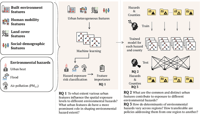
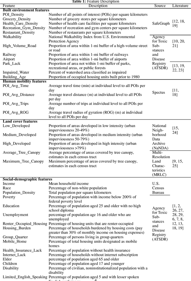
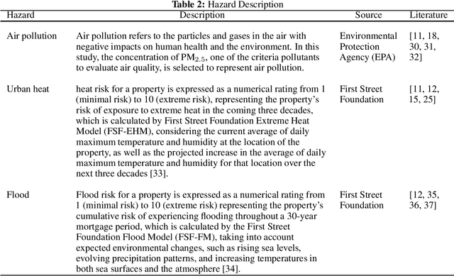
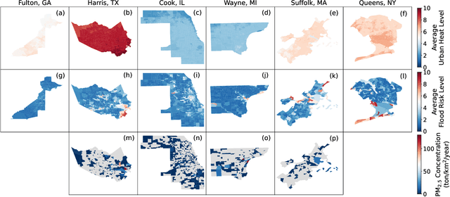
Abstract:Understanding the key factors shaping environmental hazard exposures and their associated environmental injustice issues is vital for formulating equitable policy measures. Traditional perspectives on environmental injustice have primarily focused on the socioeconomic dimensions, often overlooking the influence of heterogeneous urban characteristics. This limited view may obstruct a comprehensive understanding of the complex nature of environmental justice and its relationship with urban design features. To address this gap, this study creates an interpretable machine learning model to examine the effects of various urban features and their non-linear interactions to the exposure disparities of three primary hazards: air pollution, urban heat, and flooding. The analysis trains and tests models with data from six metropolitan counties in the United States using Random Forest and XGBoost. The performance is used to measure the extent to which variations of urban features shape disparities in environmental hazard levels. In addition, the analysis of feature importance reveals features related to social-demographic characteristics as the most prominent urban features that shape hazard extent. Features related to infrastructure distribution and land cover are relatively important for urban heat and air pollution exposure respectively. Moreover, we evaluate the models' transferability across different regions and hazards. The results highlight limited transferability, underscoring the intricate differences among hazards and regions and the way in which urban features shape hazard exposures. The insights gleaned from this study offer fresh perspectives on the relationship among urban features and their interplay with environmental hazard exposure disparities, informing the development of more integrated urban design policies to enhance social equity and environmental injustice issues.
FairMobi-Net: A Fairness-aware Deep Learning Model for Urban Mobility Flow Generation
Jul 20, 2023


Abstract:Generating realistic human flows across regions is essential for our understanding of urban structures and population activity patterns, enabling important applications in the fields of urban planning and management. However, a notable shortcoming of most existing mobility generation methodologies is neglect of prediction fairness, which can result in underestimation of mobility flows across regions with vulnerable population groups, potentially resulting in inequitable resource distribution and infrastructure development. To overcome this limitation, our study presents a novel, fairness-aware deep learning model, FairMobi-Net, for inter-region human flow prediction. The FairMobi-Net model uniquely incorporates fairness loss into the loss function and employs a hybrid approach, merging binary classification and numerical regression techniques for human flow prediction. We validate the FairMobi-Net model using comprehensive human mobility datasets from four U.S. cities, predicting human flow at the census-tract level. Our findings reveal that the FairMobi-Net model outperforms state-of-the-art models (such as the DeepGravity model) in producing more accurate and equitable human flow predictions across a variety of region pairs, regardless of regional income differences. The model maintains a high degree of accuracy consistently across diverse regions, addressing the previous fairness concern. Further analysis of feature importance elucidates the impact of physical distances and road network structures on human flows across regions. With fairness as its touchstone, the model and results provide researchers and practitioners across the fields of urban sciences, transportation engineering, and computing with an effective tool for accurate generation of human mobility flows across regions.
 Add to Chrome
 Add to Firefox
 Add to Edge