 Add to Chrome
 Add to Firefox
 Add to Edge
A Survey of Large Language Model-Powered Spatial Intelligence Across Scales: Advances in Embodied Agents, Smart Cities, and Earth Science
Apr 14, 2025Over the past year, the development of large language models (LLMs) has brought spatial intelligence into focus, with much attention on vision-based embodied intelligence. However, spatial intelligence spans a broader range of disciplines and scales, from navigation and urban planning to remote sensing and earth science. What are the differences and connections between spatial intelligence across these fields? In this paper, we first review human spatial cognition and its implications for spatial intelligence in LLMs. We then examine spatial memory, knowledge representations, and abstract reasoning in LLMs, highlighting their roles and connections. Finally, we analyze spatial intelligence across scales -- from embodied to urban and global levels -- following a framework that progresses from spatial memory and understanding to spatial reasoning and intelligence. Through this survey, we aim to provide insights into interdisciplinary spatial intelligence research and inspire future studies.
CityLight: A Universal Model Towards Real-world City-scale Traffic Signal Control Coordination
Jun 04, 2024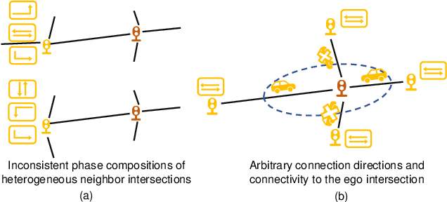
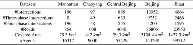
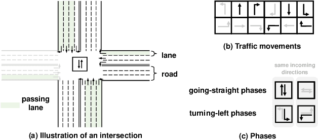
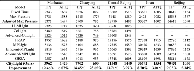
Traffic signal control (TSC) is a promising low-cost measure to enhance transportation efficiency without affecting existing road infrastructure. While various reinforcement learning-based TSC methods have been proposed and experimentally outperform conventional rule-based methods, none of them has been deployed in the real world. An essential gap lies in the oversimplification of the scenarios in terms of intersection heterogeneity and road network intricacy. To make TSC applicable in urban traffic management, we target TSC coordination in city-scale high-authenticity road networks, aiming to solve the three unique and important challenges: city-level scalability, heterogeneity of real-world intersections, and effective coordination among intricate neighbor connections. Since optimizing multiple agents in a parameter-sharing paradigm can boost the training efficiency and help achieve scalability, we propose our method, CityLight, based on the well-acknowledged optimization framework, parameter-sharing MAPPO. To ensure the unified policy network can learn to fit large-scale heterogeneous intersections and tackle the intricate between-neighbor coordination, CityLight proposes a universal representation module that consists of two key designs: heterogeneous intersection alignment and neighborhood impact alignment for coordination. To further boost coordination, CityLight adopts neighborhood-integrated rewards to transition from achieving local optimal to global optimal. Extensive experiments on datasets with hundreds to tens of thousands of real-world intersections and authentic traffic demands validate the surprising effectiveness and generalizability of CityLight, with an overall performance gain of 11.66% and a 22.59% improvement in transfer scenarios in terms of throughput.
Estimating On-road Transportation Carbon Emissions from Open Data of Road Network and Origin-destination Flow Data
Feb 07, 2024Accounting for over 20% of the total carbon emissions, the precise estimation of on-road transportation carbon emissions is crucial for carbon emission monitoring and efficient mitigation policy formulation. However, existing estimation methods typically depend on hard-to-collect individual statistics of vehicle miles traveled to calculate emissions, thereby suffering from high data collection difficulty. To relieve this issue by utilizing the strong pattern recognition of artificial intelligence, we incorporate two sources of open data representative of the transportation demand and capacity factors, the origin-destination (OD) flow data and the road network data, to build a hierarchical heterogeneous graph learning method for on-road carbon emission estimation (HENCE). Specifically, a hierarchical graph consisting of the road network level, community level, and region level is constructed to model the multi-scale road network-based connectivity and travel connection between spatial areas. Heterogeneous graphs consisting of OD links and spatial links are further built at both the community level and region level to capture the intrinsic interactions between travel demand and road network accessibility. Extensive experiments on two large-scale real-world datasets demonstrate HENCE's effectiveness and superiority with R-squared exceeding 0.75 and outperforming baselines by 9.60% on average, validating its success in pioneering the use of artificial intelligence to empower carbon emission management and sustainability development. The implementation codes are available at this link: https://github.com/tsinghua-fib-lab/HENCE.