Jialin Zhu
A Step to Decouple Optimization in 3DGS
Jan 26, 2026Abstract:3D Gaussian Splatting (3DGS) has emerged as a powerful technique for real-time novel view synthesis. As an explicit representation optimized through gradient propagation among primitives, optimization widely accepted in deep neural networks (DNNs) is actually adopted in 3DGS, such as synchronous weight updating and Adam with the adaptive gradient. However, considering the physical significance and specific design in 3DGS, there are two overlooked details in the optimization of 3DGS: (i) update step coupling, which induces optimizer state rescaling and costly attribute updates outside the viewpoints, and (ii) gradient coupling in the moment, which may lead to under- or over-effective regularization. Nevertheless, such a complex coupling is under-explored. After revisiting the optimization of 3DGS, we take a step to decouple it and recompose the process into: Sparse Adam, Re-State Regularization and Decoupled Attribute Regularization. Taking a large number of experiments under the 3DGS and 3DGS-MCMC frameworks, our work provides a deeper understanding of these components. Finally, based on the empirical analysis, we re-design the optimization and propose AdamW-GS by re-coupling the beneficial components, under which better optimization efficiency and representation effectiveness are achieved simultaneously.
CoNRec: Context-Discerning Negative Recommendation with LLMs
Jan 22, 2026Abstract:Understanding what users like is relatively straightforward; understanding what users dislike, however, remains a challenging and underexplored problem. Research into users' negative preferences has gained increasing importance in modern recommendation systems. Numerous platforms have introduced explicit negative feedback mechanisms and leverage such signals to refine their recommendation models. Beyond traditional business metrics, user experience-driven metrics, such as negative feedback rates, have become critical indicators for evaluating system performance. However, most existing approaches primarily use negative feedback as an auxiliary signal to enhance positive recommendations, paying little attention to directly modeling negative interests, which can be highly valuable in offline applications. Moreover, due to the inherent sparsity of negative feedback data, models often suffer from context understanding biases induced by positive feedback dominance. To address these challenges, we propose the first large language model framework for negative feedback modeling with special designed context-discerning modules. We use semantic ID Representation to replace text-based item descriptions and introduce an item-level alignment task that enhances the LLM's understanding of the semantic context behind negative feedback. Furthermore, we design a Progressive GRPO training paradigm that enables the model to dynamically balance the positive and negative behavioral context utilization. Besides, our investigation further reveals a fundamental misalignment between the conventional next-negative-item prediction objective and users' true negative preferences, which is heavily influenced by the system's recommendation order. To mitigate this, we propose a novel reward function and evaluation metric grounded in multi-day future negative feedback and their collaborative signals.
ChoirRec: Semantic User Grouping via LLMs for Conversion Rate Prediction of Low-Activity Users
Oct 10, 2025Abstract:Accurately predicting conversion rates (CVR) for low-activity users remains a fundamental challenge in large-scale e-commerce recommender systems.Existing approaches face three critical limitations: (i) reliance on noisy and unreliable behavioral signals; (ii) insufficient user-level information due to the lack of diverse interaction data; and (iii) a systemic training bias toward high-activity users that overshadows the needs of low-activity users.To address these challenges, we propose ChoirRec, a novel framework that leverages the semantic capabilities of Large Language Models (LLMs) to construct semantic user groups and enhance CVR prediction for low-activity users.With a dual-channel architecture designed for robust cross-user knowledge transfer, ChoirRec comprises three components: (i) a Semantic Group Generation module that utilizes LLMs to form reliable, cross-activity user clusters, thereby filtering out noisy signals; (ii) a Group-aware Hierarchical Representation module that enriches sparse user embeddings with informative group-level priors to mitigate data insufficiency; and (iii) a Group-aware Multi-granularity Modual that employs a dual-channel architecture and adaptive fusion mechanism to ensure effective learning and utilization of group knowledge. We conduct extensive offline and online experiments on Taobao, a leading industrial-scale e-commerce platform.ChoirRec improves GAUC by 1.16\% in offline evaluations, while online A/B testing reveals a 7.24\% increase in order volume, highlighting its substantial practical value in real-world applications.
RecGPT Technical Report
Jul 30, 2025


Abstract:Recommender systems are among the most impactful applications of artificial intelligence, serving as critical infrastructure connecting users, merchants, and platforms. However, most current industrial systems remain heavily reliant on historical co-occurrence patterns and log-fitting objectives, i.e., optimizing for past user interactions without explicitly modeling user intent. This log-fitting approach often leads to overfitting to narrow historical preferences, failing to capture users' evolving and latent interests. As a result, it reinforces filter bubbles and long-tail phenomena, ultimately harming user experience and threatening the sustainability of the whole recommendation ecosystem. To address these challenges, we rethink the overall design paradigm of recommender systems and propose RecGPT, a next-generation framework that places user intent at the center of the recommendation pipeline. By integrating large language models (LLMs) into key stages of user interest mining, item retrieval, and explanation generation, RecGPT transforms log-fitting recommendation into an intent-centric process. To effectively align general-purpose LLMs to the above domain-specific recommendation tasks at scale, RecGPT incorporates a multi-stage training paradigm, which integrates reasoning-enhanced pre-alignment and self-training evolution, guided by a Human-LLM cooperative judge system. Currently, RecGPT has been fully deployed on the Taobao App. Online experiments demonstrate that RecGPT achieves consistent performance gains across stakeholders: users benefit from increased content diversity and satisfaction, merchants and the platform gain greater exposure and conversions. These comprehensive improvement results across all stakeholders validates that LLM-driven, intent-centric design can foster a more sustainable and mutually beneficial recommendation ecosystem.
Learning Extremely High Density Crowds as Active Matters
Mar 15, 2025


Abstract:Video-based high-density crowd analysis and prediction has been a long-standing topic in computer vision. It is notoriously difficult due to, but not limited to, the lack of high-quality data and complex crowd dynamics. Consequently, it has been relatively under studied. In this paper, we propose a new approach that aims to learn from in-the-wild videos, often with low quality where it is difficult to track individuals or count heads. The key novelty is a new physics prior to model crowd dynamics. We model high-density crowds as active matter, a continumm with active particles subject to stochastic forces, named 'crowd material'. Our physics model is combined with neural networks, resulting in a neural stochastic differential equation system which can mimic the complex crowd dynamics. Due to the lack of similar research, we adapt a range of existing methods which are close to ours for comparison. Through exhaustive evaluation, we show our model outperforms existing methods in analyzing and forecasting extremely high-density crowds. Furthermore, since our model is a continuous-time physics model, it can be used for simulation and analysis, providing strong interpretability. This is categorically different from most deep learning methods, which are discrete-time models and black-boxes.
3D Student Splatting and Scooping
Mar 13, 2025


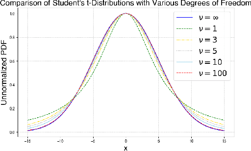
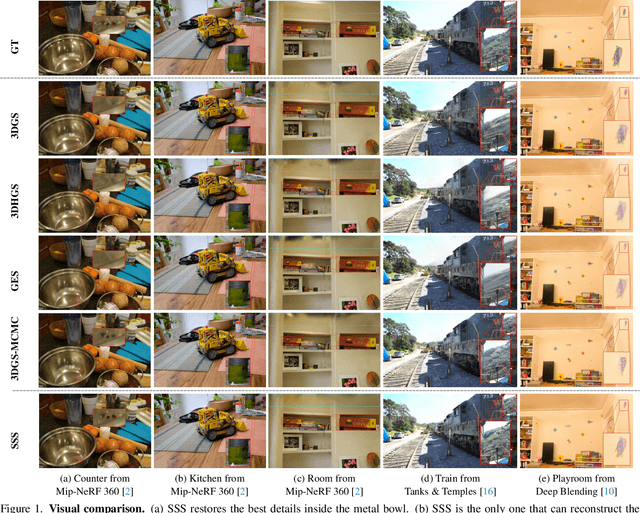
Abstract:Recently, 3D Gaussian Splatting (3DGS) provides a new framework for novel view synthesis, and has spiked a new wave of research in neural rendering and related applications. As 3DGS is becoming a foundational component of many models, any improvement on 3DGS itself can bring huge benefits. To this end, we aim to improve the fundamental paradigm and formulation of 3DGS. We argue that as an unnormalized mixture model, it needs to be neither Gaussians nor splatting. We subsequently propose a new mixture model consisting of flexible Student's t distributions, with both positive (splatting) and negative (scooping) densities. We name our model Student Splatting and Scooping, or SSS. When providing better expressivity, SSS also poses new challenges in learning. Therefore, we also propose a new principled sampling approach for optimization. Through exhaustive evaluation and comparison, across multiple datasets, settings, and metrics, we demonstrate that SSS outperforms existing methods in terms of quality and parameter efficiency, e.g. achieving matching or better quality with similar numbers of components, and obtaining comparable results while reducing the component number by as much as 82%.
Ordered Genetic Algorithm for Entrance Dependent Vehicle Routing Problem in Farms
Feb 26, 2025Abstract:Vehicle Routing Problems (VRP) are widely studied issues that play important roles in many production scenarios. We have noticed that in some practical scenarios of VRP, the size of cities and their entrances can significantly influence the optimization process. To address this, we have constructed the Entrance Dependent VRP (EDVRP) to describe such problems. We provide a mathematical formulation for the EDVRP in farms and propose an Ordered Genetic Algorithm (OGA) to solve it. The effectiveness of OGA is demonstrated through our experiments, which involve a multitude of randomly generated cases. The results indicate that OGA offers certain advantages compared to a random strategy baseline and a genetic algorithm without ordering. Furthermore, the novel operators introduced in this paper have been validated through ablation experiments, proving their effectiveness in enhancing the performance of the algorithm.
Spectrum Sharing between UAV-based Wireless Mesh Networks and Ground Networks
Nov 25, 2023Abstract:The unmanned aerial vehicle (UAV)-based wireless mesh networks can economically provide wireless services for the areas with disasters. However, the capacity of air-to-air communications is limited due to the multi-hop transmissions. In this paper, the spectrum sharing between UAV-based wireless mesh networks and ground networks is studied to improve the capacity of the UAV networks. Considering the distribution of UAVs as a three-dimensional (3D) homogeneous Poisson point process (PPP) within a vertical range, the stochastic geometry is applied to analyze the impact of the height of UAVs, the transmit power of UAVs, the density of UAVs and the vertical range, etc., on the coverage probability of ground network user and UAV network user, respectively. The optimal height of UAVs is numerically achieved in maximizing the capacity of UAV networks with the constraint of the coverage probability of ground network user. This paper provides a basic guideline for the deployment of UAV-based wireless mesh networks.
The Performance Analysis of Spectrum Sharing between UAV enabled Wireless Mesh Networks and Ground Networks
Nov 25, 2023Abstract:Unmanned aerial vehicle (UAV) has the advantages of large coverage and flexibility, which could be applied in disaster management to provide wireless services to the rescuers and victims. When UAVs forms an aerial mesh network, line-of-sight (LoS) air-to-air (A2A) communications have long transmission distance, which extends the coverage of multiple UAVs. However, the capacity of UAV is constrained due to the multiple hop transmissions in aerial mesh networks. In this paper, spectrum sharing between UAV enabled wireless mesh networks and ground networks is studied to improve the capacity of UAV networks. Considering two-dimensional (2D) and three-dimensional (3D) homogeneous Poisson point process (PPP) modeling for the distribution of UAVs within a vertical range {\Delta}h, stochastic geometry is applied to analyze the impact of the height of UAVs, the transmit power of UAVs, the density of UAVs and the vertical range, etc., on the coverage probability of ground network user and UAV network user. Besides, performance improvement of spectrum sharing with directional antenna is verified. With the object function of maximizing the transmission capacity, the optimal altitude of UAVs is obtained. This paper provides a theoretical guideline for the spectrum sharing of UAV enabled wireless mesh networks, which may contribute significant value to the study of spectrum sharing mechanisms for UAV enabled wireless mesh networks.
Seamless Satellite-image Synthesis
Nov 05, 2021


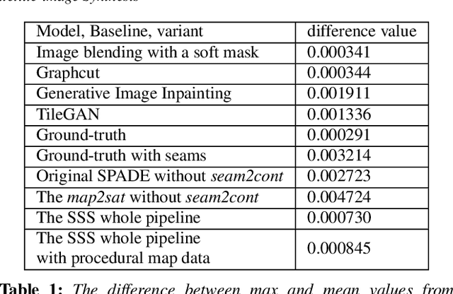
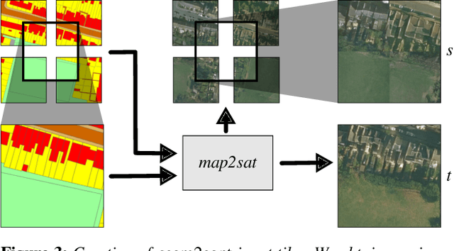
Abstract:We introduce Seamless Satellite-image Synthesis (SSS), a novel neural architecture to create scale-and-space continuous satellite textures from cartographic data. While 2D map data is cheap and easily synthesized, accurate satellite imagery is expensive and often unavailable or out of date. Our approach generates seamless textures over arbitrarily large spatial extents which are consistent through scale-space. To overcome tile size limitations in image-to-image translation approaches, SSS learns to remove seams between tiled images in a semantically meaningful manner. Scale-space continuity is achieved by a hierarchy of networks conditioned on style and cartographic data. Our qualitative and quantitative evaluations show that our system improves over the state-of-the-art in several key areas. We show applications to texturing procedurally generation maps and interactive satellite image manipulation.
 Add to Chrome
 Add to Firefox
 Add to Edge