Zijun Guo
An Evolutionary Game-Theoretic Merging Decision-Making Considering Social Acceptance for Autonomous Driving
Aug 09, 2025Abstract:Highway on-ramp merging is of great challenge for autonomous vehicles (AVs), since they have to proactively interact with surrounding vehicles to enter the main road safely within limited time. However, existing decision-making algorithms fail to adequately address dynamic complexities and social acceptance of AVs, leading to suboptimal or unsafe merging decisions. To address this, we propose an evolutionary game-theoretic (EGT) merging decision-making framework, grounded in the bounded rationality of human drivers, which dynamically balances the benefits of both AVs and main-road vehicles (MVs). We formulate the cut-in decision-making process as an EGT problem with a multi-objective payoff function that reflects human-like driving preferences. By solving the replicator dynamic equation for the evolutionarily stable strategy (ESS), the optimal cut-in timing is derived, balancing efficiency, comfort, and safety for both AVs and MVs. A real-time driving style estimation algorithm is proposed to adjust the game payoff function online by observing the immediate reactions of MVs. Empirical results demonstrate that we improve the efficiency, comfort and safety of both AVs and MVs compared with existing game-theoretic and traditional planning approaches across multi-object metrics.
Spectrum Sharing between UAV-based Wireless Mesh Networks and Ground Networks
Nov 25, 2023Abstract:The unmanned aerial vehicle (UAV)-based wireless mesh networks can economically provide wireless services for the areas with disasters. However, the capacity of air-to-air communications is limited due to the multi-hop transmissions. In this paper, the spectrum sharing between UAV-based wireless mesh networks and ground networks is studied to improve the capacity of the UAV networks. Considering the distribution of UAVs as a three-dimensional (3D) homogeneous Poisson point process (PPP) within a vertical range, the stochastic geometry is applied to analyze the impact of the height of UAVs, the transmit power of UAVs, the density of UAVs and the vertical range, etc., on the coverage probability of ground network user and UAV network user, respectively. The optimal height of UAVs is numerically achieved in maximizing the capacity of UAV networks with the constraint of the coverage probability of ground network user. This paper provides a basic guideline for the deployment of UAV-based wireless mesh networks.
The Performance Analysis of Spectrum Sharing between UAV enabled Wireless Mesh Networks and Ground Networks
Nov 25, 2023Abstract:Unmanned aerial vehicle (UAV) has the advantages of large coverage and flexibility, which could be applied in disaster management to provide wireless services to the rescuers and victims. When UAVs forms an aerial mesh network, line-of-sight (LoS) air-to-air (A2A) communications have long transmission distance, which extends the coverage of multiple UAVs. However, the capacity of UAV is constrained due to the multiple hop transmissions in aerial mesh networks. In this paper, spectrum sharing between UAV enabled wireless mesh networks and ground networks is studied to improve the capacity of UAV networks. Considering two-dimensional (2D) and three-dimensional (3D) homogeneous Poisson point process (PPP) modeling for the distribution of UAVs within a vertical range {\Delta}h, stochastic geometry is applied to analyze the impact of the height of UAVs, the transmit power of UAVs, the density of UAVs and the vertical range, etc., on the coverage probability of ground network user and UAV network user. Besides, performance improvement of spectrum sharing with directional antenna is verified. With the object function of maximizing the transmission capacity, the optimal altitude of UAVs is obtained. This paper provides a theoretical guideline for the spectrum sharing of UAV enabled wireless mesh networks, which may contribute significant value to the study of spectrum sharing mechanisms for UAV enabled wireless mesh networks.
Fast localization and single-pixel imaging of the moving object using time-division multiplexing
Aug 15, 2022


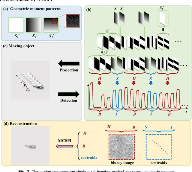
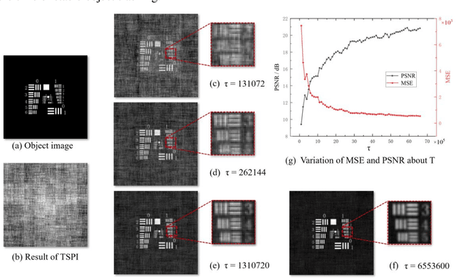
Abstract:When imaging moving objects, single-pixel imaging produces motion blur. This paper proposes a new single-pixel imaging method, which can achieve anti-motion blur imaging of a fast-moving object. The geometric moment patterns and Hadamard patterns are used to alternately encode the position information and the image information of the object with time-division multiplexing. In the reconstruction process, the object position information is extracted independently and combining motion-compensation reconstruction algorithm to decouple the object motion from image information. As a result, the anti-motion blur image and the high frame rate object positions are obtained. Experimental results show that for a moving object with an angular velocity of up to 0.5rad/s relative to the imaging system, the proposed method achieves a localization frequency of 5.55kHz, and gradually reconstructs a clear image of the fast-moving object with a pseudo resolution of 512x512. The method has application prospects in single-pixel imaging of the fast-moving object.
 Add to Chrome
 Add to Firefox
 Add to Edge